Wildfire smoke continues to impact air quality from the Great Lakes region into New England and the Mid-Atlantic today with widespread Air Quality Alerts in effect. Severe thunderstorms are expected across portions of the Ohio Valley and Lower Great Lakes into the Mid-Atlantic and Northeast, this afternoon into the evening. Monsoonal thunderstorms may bring areas of flooding to the Southwest. Read More >
Overview - Atmospheric River - February 3-5, 2024
Heavy Rains and Damaging Winds Impacted the Bay Area and the Central Coast
|
Event Highlights
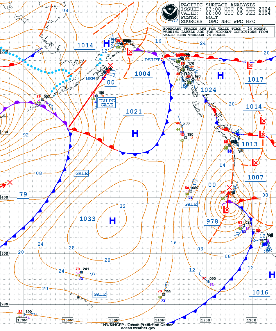
Zonal flow across the Pacific became highly amplified leading to explosive cyclogenesis February 3-5, 2024. Rapidly deepening low pressure systems off the West Coast are not that uncommon during the winter months. In fact, this low pressure system deepened enough in 24 hours to reach "bomb cyclone" status (see below for details). What else sets this low pressure system apart from past bomb cyclones was the southern extent latitude wise it deepened. The last time a low pressure near 980 mb developed off the Bay Area coast was January 2010. As the low pressure system moved eastward it developed characteristics of a "sting jet" on the SW side. Uncertain if a true sting jet developed, but regardless damaging winds impacted the region. These strong winds first materialized along the Big Sur Coast with gusts of 80-90 mph before spreading to the Santa Cruz Mountains next and lastly to the North Bay Mountains. Peak wind observed was 102 mph at a mesonet station in the North Bay Coastal Mountains. These strong winds led to numerous downed trees and widespread power outages. One utility company shared it was one of the top three most damaging, single-day storms on record, only comparable to storms in 1995 and 2008. Overall, more than one million customers lost power at some point during the storm. This event will clearly be remembered for the wind impacts, but it did also rain. The deep low pressure was able to tap into subtropical moisture and aim it at the coast as an Atmospheric River. Intense rainfall quickly overwhelmed some creeks and streams leading to minor flooding. Thankfully, the large rivers were able to accommodate the rain. Bomb Cyclone Stats: Minimum central pressure of cyclone was 978mb (see below). Total pressure drop was 30mb in 33 hours with a maximum pressure drop 22mb in 24 hours (1.3 Bergeron when adjusted for latitude). Verification of the Bomb Cyclone (definition here).
|
Radar Loop showing full scope of Atmospheric River. |
Strong Southerly Winds
As the low pressure off the California coast began to "bomb out" the surface pressure gradient increased rapidly leading to increasing southerly winds. Winds initially increased offshore and then increased over land on February 4, 2024. The strongest land-based winds first impacted the Big Sur before spreading north to the Santa Cruz Mountains/East Bay Hills and finally the North Bay Mountains. Pretty impressive to see winds greater than 90 mph! Needless to say, saturated soils and strong winds led to numerous downed trees with widespread power outages.
 |
 |
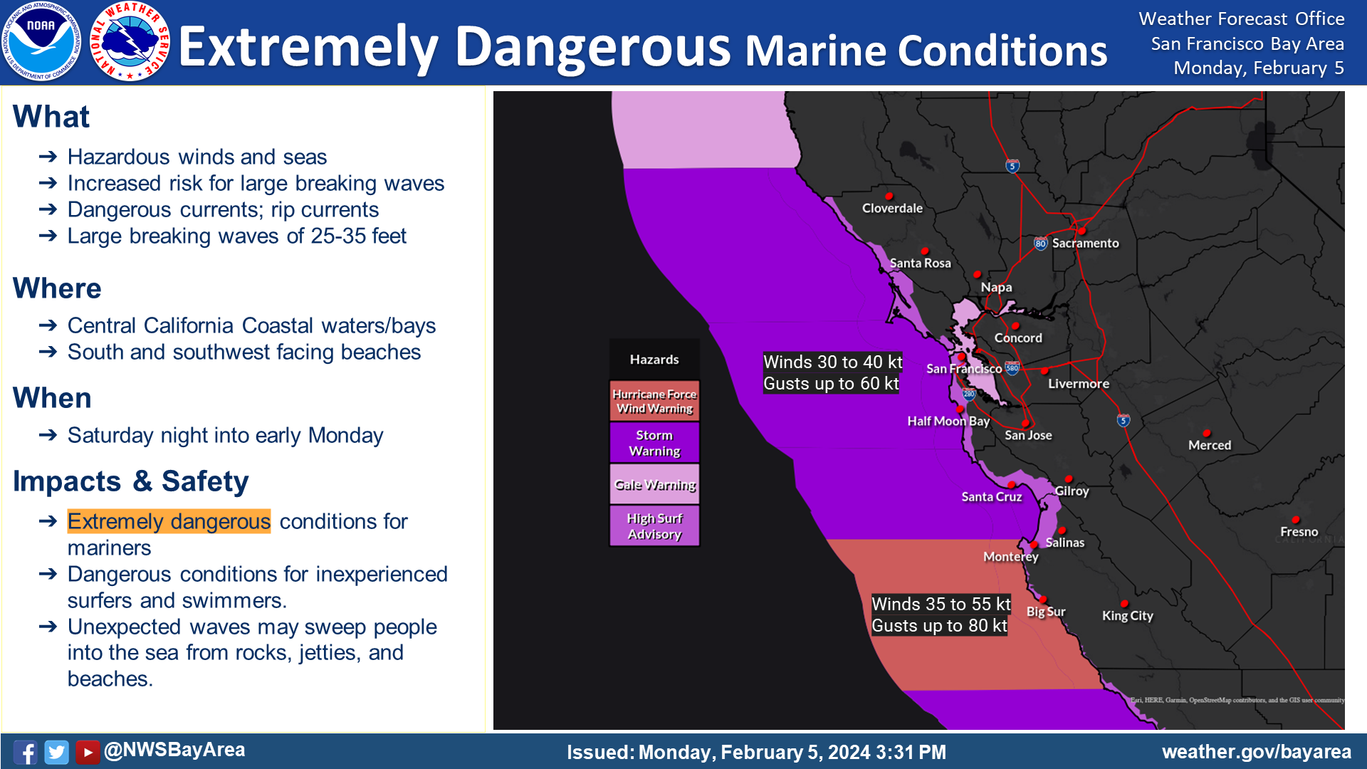 |
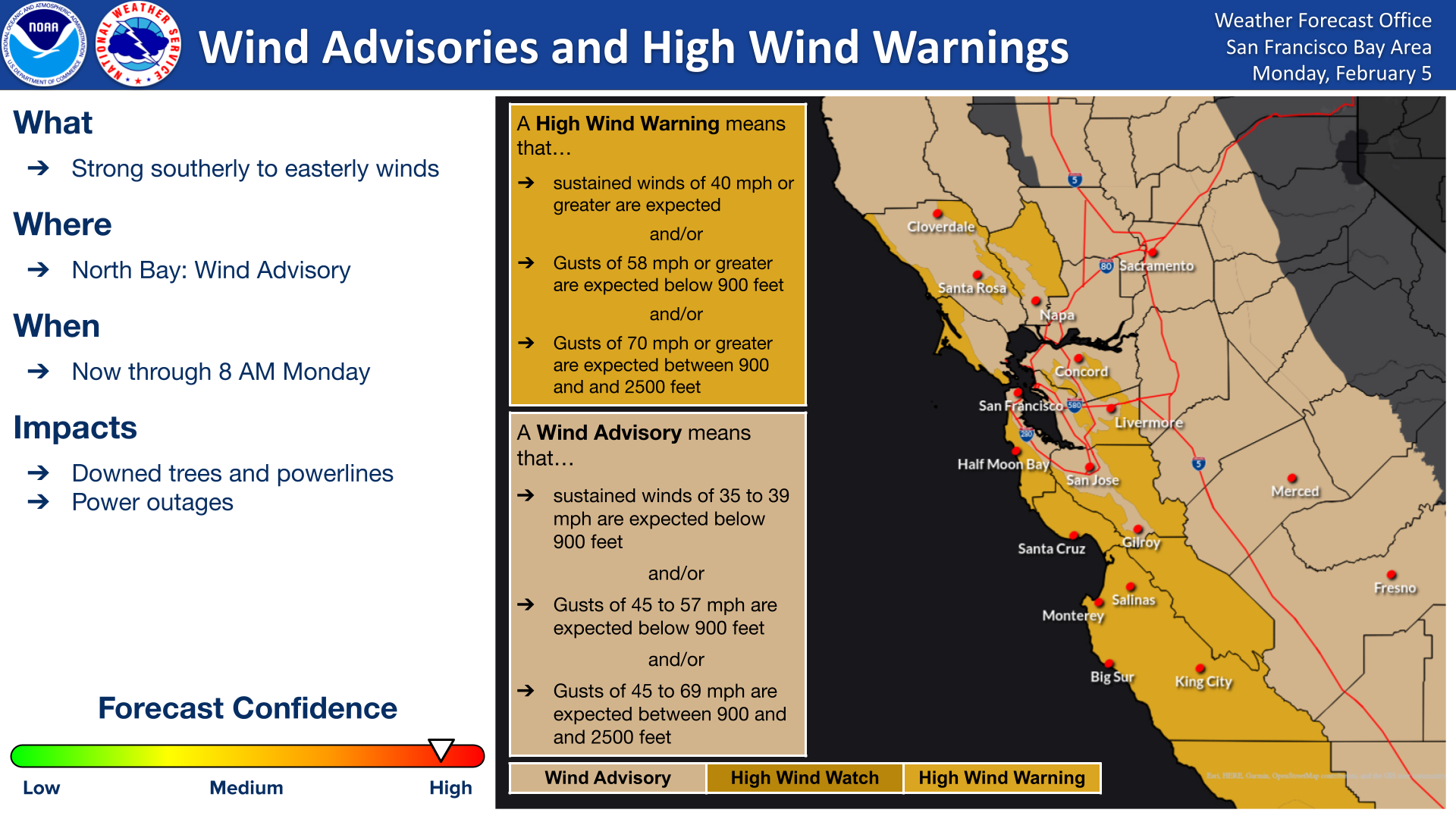
| High Wind Warning and Wind Advisories were issued. | Peak Wind Gust Map. | Strong winds created dangerous conditions on the coastal waters and bays. First Ever Hurricane Force Warning was issued from NWS Bay Area. |
Public Information Statement
National Weather Service San Francisco CA

..TIME...   ...EVENT...      ...CITY LOCATION...     ...LAT.LON...
..DATE...   ....MAG....      ..COUNTY LOCATION..ST.. ...SOURCE....
            ..REMARKS..

0206 AM     Non-Tstm Wnd Dmg SR1/Pacific View Dr     38.55N 123.29W
02/04/2024                   Sonoma             CA   Law Enforcement

            Several trees down and blocking NB and SB
            lanes.

0358 AM     Non-Tstm Wnd Dmg SR1/Timber Cove Rd      38.54N 123.28W
02/04/2024                   Sonoma             CA   Law Enforcement

            Large tree blocking roadway and guard rail.

0630 AM     Non-Tstm Wnd Dmg Boyes Hot Springs       38.31N 122.48W
02/04/2024                   Sonoma             CA   Public

            Tree down onto home, no injuries.

0800 AM     Non-Tstm Wnd Dmg 1 SSE South Santa Rosa  38.39N 122.72W
02/04/2024                   Sonoma             CA   Public

            *** 1 INJ ***
            Redwood tree down on car on Hwy 101, 1 inj,
            freeway blocked.

1207 AM     Non-Tstm Wnd Dmg 3148 Calistoga Rd       38.54N 122.65W
02/05/2024                   Sonoma             CA   Law Enforcement

            Large redwood tree fell and is across entire
            road, road is closed in both directions.

0938 AM     Non-Tstm Wnd Dmg 4 E Scotts Valley       37.06N 121.94W
02/04/2024                   Santa Cruz         CA   Law Enforcement

            Road closure at Soquel San Jose Rd north of
            Olson Rd is closed due to fallen tree
            blocking road. CHP report via Twitter.

1212 PM     Non-Tstm Wnd Dmg 2 S Live Oak            36.96N 121.98W
02/04/2024                   Santa Cruz         CA   Emergency Mngr

            Downed eucalyptus tree fell into residential
            home, resulting in extensive damage to the
            home. No injuries as no one was home at the
            time.

0354 PM     Non-Tstm Wnd Dmg 220 Brackney Rd         37.07N 122.08W
02/04/2024                   Santa Cruz         CA   Law Enforcement

            Transformer down, but not the pole. Negative
            for arcing or sparking.

0509 PM     Non-Tstm Wnd Dmg Quail Hollow Rd/Marion  37.09N 122.07W
02/04/2024                   Santa Cruz         CA   Law Enforcement

            Large redwood tree limbs in roadway into
            intersection, branches blocking all of EB
            lane.

0531 PM     Non-Tstm Wnd Dmg Vine Hill Rd/Thin Edge  37.07N 121.98W
02/04/2024                   Santa Cruz         CA   Law Enforcement

            Several trees and a power line down across
            the roadway.

0651 PM     Non-Tstm Wnd Dmg Freedom Blvd/Titus Ln   36.99N 121.85W
02/04/2024                   Santa Cruz         CA   Law Enforcement

            Power lines down across the roadway.

1105 PM     Non-Tstm Wnd Dmg Valencia Rd/Indian Holl 36.99N 121.88W
02/04/2024                   Santa Cruz         CA   Law Enforcement

            Tree down and 40 feet past the tree are
            wires in the roadway.

0958 PM     Non-Tstm Wnd Dmg US101 S/Blossom Hill Rd 37.26N 121.79W
02/04/2024                   Santa Clara        CA   Law Enforcement

            Sticks and debris within the offramp to 1/4
            into SB 101 slow lane.

1008 PM     Non-Tstm Wnd Dmg NB 85 to NB 87 connecto 37.26N 121.86W
02/04/2024                   Santa Clara        CA   Law Enforcement

            Tree in lane #1.

1041 PM     Non-Tstm Wnd Dmg NB 101 to NB 680 connec 37.34N 121.85W
02/04/2024                   Santa Clara        CA   Law Enforcement

            Tree down.

1101 AM     Non-Tstm Wnd Dmg Moss Beach              37.53N 122.52W
02/04/2024                   San Mateo          CA   Fire Dept/Rescue

            Downed tree blocking Arbor Lane in Moss
            Beach. Report from Cal Fire CZU via Twitter.

0558 PM     Non-Tstm Wnd Dmg US 101 S/Embarcadero Rd 37.46N 122.13W
02/04/2024                   San Mateo          CA   Law Enforcement

            Light pole down blocking #2 exit lane and 45
            foot tree down blocking 1-2 lane, offramp is
            closed.

0235 AM     Non-Tstm Wnd Dmg NB SR29/S Kelly Rd      38.21N 122.26W
02/04/2024                   Napa               CA   Law Enforcement

            Tree blocking entire #2 lane and part of #1
            lane on NB SR29 just north of S Kelly Rd.

0358 AM     Non-Tstm Wnd Dmg SR12 W/N Kelly Rd       38.23N 122.25W
02/04/2024                   Napa               CA   Law Enforcement

            Tree down blocking NB/SB lanes.

1026 PM     Non-Tstm Wnd Dmg 975 Golden Gate Dr      38.28N 122.30W
02/04/2024                   Napa               CA   Law Enforcement

            Power lines down, road closed.

0116 AM     Non-Tstm Wnd Dmg 5910 Garrapatos Rd      36.41N 121.87W
02/04/2024                   Monterey           CA   Law Enforcement

            Power line across single lane dirt road.

0711 AM     Non-Tstm Wnd Dmg 6 S Del Monte Forest    36.50N 121.94W
02/04/2024                   Monterey           CA   Law Enforcement

            Large tree on roadway.

0751 AM     Non-Tstm Wnd Dmg 13 S Big Sur            36.12N 121.63W
02/04/2024                   Monterey           CA   Public

            Large tree down blocking both lanes.

0933 AM     Non-Tstm Wnd Dmg 1 ENE Castroville       36.77N 121.73W
02/04/2024                   Monterey           CA   Law Enforcement

            Power lines down in road, caused fire.

1128 AM     Non-Tstm Wnd Dmg 2 E Del Monte Forest    36.59N 121.92W
02/04/2024                   Monterey           CA   Law Enforcement

            Tree blocking SB lane of SR 68 at Skyline
            Forest Dr. Resulted in vehicle accident.

1145 AM     Non-Tstm Wnd Dmg 6 S Del Monte Forest    36.50N 121.94W
02/04/2024                   Monterey           CA   Law Enforcement

            Multiple trees down on the road, blocking
            both lanes of SR 1.

1212 PM     Non-Tstm Wnd Dmg 2 S Salinas             36.66N 121.64W
02/04/2024                   Monterey           CA   Law Enforcement

            Power lines, trees and slides blocking
            roadway near E Blanco Street.

1244 PM     Non-Tstm Wnd Dmg 1 SE Del Rey Oaks       36.58N 121.82W
02/04/2024                   Monterey           CA   NWS Employee

            Tree damage due to strong winds near Ryan
            Ranch in Monterey. Picture via Twitter shows
            large tree branches have been snapped.

1108 PM     Non-Tstm Wnd Dmg US101 S/SR156 WB        36.80N 121.67W
02/04/2024                   Monterey           CA   Law Enforcement

            Large tree down in the merge lane and slow
            lane, roadway will be cleared in a few
            minutes.

0512 AM     Non-Tstm Wnd Dmg SR1 S/Munras offramp    36.59N 121.90W
02/05/2024                   Monterey           CA   Law Enforcement

            Tree down across the roadway.

1216 AM     Non-Tstm Wnd Dmg I580 W/35th Ave onramp  37.80N 122.21W
02/04/2024                   Alameda            CA   Law Enforcement

            Tree in slow lane.


&&

$$
|
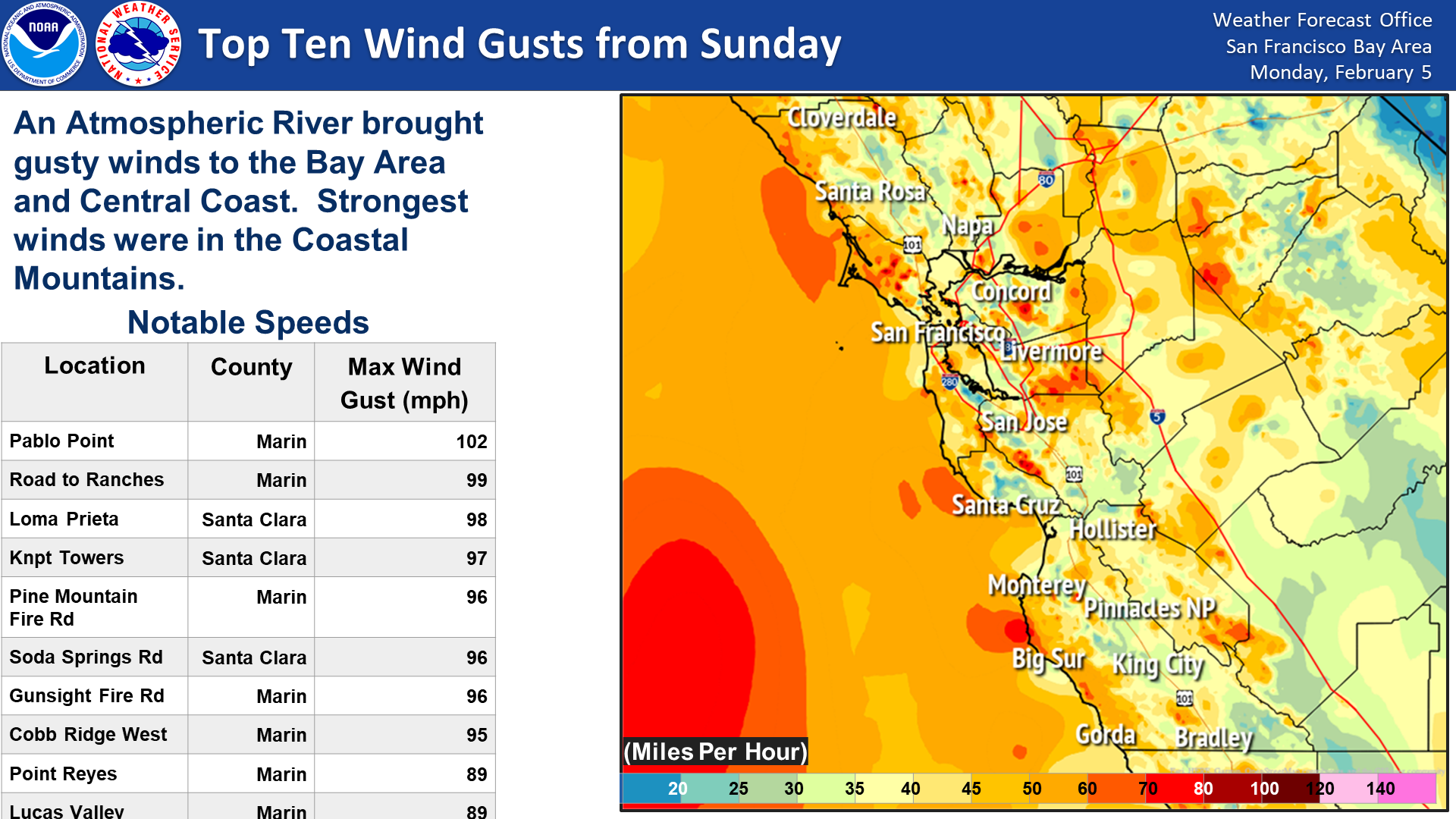
Public Information Statement National Weather Service San Francisco CA 809 PM PST Sun Feb 4 2024 ...HIGHEST WIND REPORTS... Location Speed Time/Date Lat/Lon Pablo Point 102 MPH 0440 PM 02/04 38.09N/122.69W Road To Ranches 99 MPH 0540 PM 02/04 38.06N/122.73W Loma Prieta 98 MPH 0235 PM 02/04 37.14N/121.89W Knpt Towers 97 MPH 0330 PM 02/04 37.11N/121.84W Pine Mountain Fire Road 96 MPH 0250 PM 02/04 37.98N/122.65W Soda Springs Road 96 MPH 0440 PM 02/04 37.17N/121.94W Gunsight Fire Road 96 MPH 0530 PM 02/04 38.02N/122.63W Cobb Ridge West 95 MPH 0610 PM 02/04 38.82N/122.81W Point Reyes 89 MPH 0220 PM 02/04 38.00N/123.01W Lucas Valley 89 MPH 0410 PM 02/04 38.05N/122.60W 12.7 SW Carmel Valley Vill 88 MPH 1020 AM 02/04 36.35N/121.88W Los Gatos Raws 87 MPH 0532 PM 02/04 37.20N/121.95W Atlas Peak RAWS 86 MPH 0729 PM 02/04 38.47N/122.26W Lime Creek Road 85 MPH 0910 AM 02/04 36.11N/121.63W Mt. Umunhum 85 MPH 0320 PM 02/04 37.16N/121.91W Mt Diablo 83 MPH 0430 PM 02/04 37.88N/121.91W Mines Tower 82 MPH 0650 PM 02/04 37.61N/121.62W 4.5 SW Forest Lake (PGE) 81 MPH 0650 PM 02/04 38.76N/122.76W Richardson East 81 MPH 0550 PM 02/04 37.85N/122.50W Mt. Alison 81 MPH 0350 PM 02/04 37.50N/121.87W 4.8 SW Anderson Springs (PGE)80 MPH 0600 PM 02/04 38.73N/122.76W 7.0 E Carmel Valley Vill 80 MPH 0200 PM 02/04 36.53N/121.61W Laureles Grade Road South 79 MPH 0130 PM 02/04 36.51N/121.74W Pittsburg 79 MPH 0500 PM 02/04 37.89N/121.90W 12.4 SW Carmel Valley Vill 79 MPH 1000 AM 02/04 36.38N/121.90W Rose Peak 79 MPH 0528 PM 02/04 37.50N/121.74W King Ridge 78 MPH 0500 PM 02/04 38.60N/123.20W South Black Diamond Way 78 MPH 0630 PM 02/04 37.94N/121.89W Diablo-Blackhawk 78 MPH 0550 PM 02/04 37.84N/121.90W San Francisco Airport 77 MPH 0329 PM 02/04 37.62N/122.37W 17.0 S Carmel Valley Vill 77 MPH 0930 AM 02/04 36.25N/121.79W Sierra Azul 77 MPH 0340 PM 02/04 37.18N/121.92W Francis Drake Hills South 76 MPH 0230 PM 02/04 38.09N/122.92W La Honda 76 MPH 0520 PM 02/04 37.30N/122.17W 16.9 NW Lake Nacimiento (PGE)76 MPH 1020 AM 02/04 35.95N/121.00W Hunter Liggett 76 MPH 0340 PM 02/04 35.95N/121.23W Mines Road North 76 MPH 0640 AM 02/04 37.61N/121.67W Monte Bello Road West 76 MPH 0320 PM 02/04 37.30N/122.12W Lone Tree Towers 75 MPH 0130 PM 02/04 36.93N/121.24W 24.9 SW Greenfield (DRI) 75 MPH 0820 AM 02/04 36.07N/121.56W Highlands Peak Met Station N 75 MPH 0820 AM 02/04 36.05N/121.56W 1.3 W Woodacre (PGE) 75 MPH 0300 PM 02/04 38.00N/122.66W Tomales Bay 75 MPH 0238 PM 02/04 38.18N/122.91W Meyers Grade 74 MPH 0250 PM 02/04 38.51N/123.20W Las Trampas 74 MPH 0528 PM 02/04 37.83N/122.07W Santa Fe Geothermal 74 MPH 0650 PM 02/04 38.79N/122.75W Alcosta Boulevard 74 MPH 0440 PM 02/04 37.75N/121.93W Weller Road 73 MPH 1050 AM 02/04 37.49N/121.86W Sand Haul Road 73 MPH 0240 PM 02/04 38.25N/122.95W Black Mountain 73 MPH 0220 PM 02/04 37.33N/122.18W 8.2 N Healdsburg (PGE) 73 MPH 0430 PM 02/04 38.74N/122.83W Mt Bielawski 73 MPH 0320 PM 02/04 37.22N/122.03W 7.3 N Guerneville (PGE) 73 MPH 0420 PM 02/04 38.61N/123.00W Coleman Valley Road South 73 MPH 0610 PM 02/04 38.37N/123.05W Priest Rock 73 MPH 0330 PM 02/04 37.19N/121.96W Poo107 Loma Chiquita 72 MPH 0330 PM 02/04 37.10N/121.83W Byron Hot Springs 72 MPH 1030 AM 02/04 37.80N/121.64W Hawkeye Raws 72 MPH 0656 PM 02/04 38.74N/122.84W Cummins Peak 72 MPH 0550 PM 02/04 38.03N/122.20W Lake Drive 72 MPH 0520 PM 02/04 37.62N/122.45W Santa Rita 72 MPH 0257 PM 02/04 36.35N/120.60W Duck Cove Road 71 MPH 0530 PM 02/04 38.14N/122.92W Oak Ridge 71 MPH 0333 PM 02/04 38.74N/123.31W Corral De Cielo Road 71 MPH 0220 PM 02/04 36.53N/121.62W Los Gatos 70 MPH 0305 PM 02/04 37.20N/122.07W Big Rock 70 MPH 0533 PM 02/04 38.04N/122.57W Kahler Court 70 MPH 0810 AM 02/04 37.43N/121.81W Contra Costa 70 MPH 1040 AM 02/04 37.92N/121.98W Peninsula 69 MPH 0340 PM 02/04 37.33N/122.21W Kortum Trail 69 MPH 0510 PM 02/04 38.42N/123.10W 2.8 SW San Juan Bautista 69 MPH 0950 AM 02/04 36.83N/121.58W 7.5 W Monte Rio (PGE) 69 MPH 0240 PM 02/04 38.51N/123.14W 5.5 E Fremont (PGE) 69 MPH 0530 PM 02/04 37.55N/121.90W Cerini Road 69 MPH 0420 PM 02/04 38.23N/122.86W Boundary 69 MPH 0400 PM 02/04 37.21N/121.77W Pebble Beach 68 MPH 1130 AM 02/04 36.58N/121.97W Paicines 68 MPH 1250 PM 02/04 36.57N/120.96W 11.8 NW Monte Rio (PGE) 68 MPH 0400 PM 02/04 38.55N/123.20W Fay Hill 68 MPH 0500 PM 02/04 37.86N/122.12W Marshall Petaluma Road 68 MPH 0230 PM 02/04 38.16N/122.88W Black Mountain 67 MPH 0207 PM 02/04 36.38N/120.86W Half Moon Bay 67 MPH 0135 PM 02/04 37.52N/122.50W Mt St Helena 67 MPH 0350 PM 02/04 38.67N/122.63W Snake Road 67 MPH 0510 PM 02/04 38.22N/122.92W Laureles Grade 66 MPH 1200 PM 02/04 36.53N/121.75W Coggins Road 66 MPH 0310 PM 02/04 37.31N/122.26W Reuss Road 66 MPH 0940 AM 02/04 37.66N/121.66W Ridgecrest 66 MPH 0520 PM 02/04 37.92N/122.63W BIG BEAR LAKE 66 MPH 0245 PM 02/04 37.96N/121.66W Calaveras Rd Raws 66 MPH 0618 PM 02/04 37.55N/121.84W 4.0 SW Pleasanton (PGE) 66 MPH 0530 PM 02/04 37.62N/121.92W 8.0 SW Petaluma (PGE) 66 MPH 0500 PM 02/04 38.14N/122.70W Long Ridge 66 MPH 1150 AM 02/04 36.43N/121.74W Panoramic Highway 66 MPH 0510 PM 02/04 37.89N/122.56W Los Vaqueros Raws 66 MPH 1045 AM 02/04 37.79N/121.73W Corte Madera Chnl. 66 MPH 0325 PM 02/04 37.93N/122.47W 25 WSW Montara 65 MPH 0830 AM 02/04 37.33N/122.87W Osprey Drive 65 MPH 0530 PM 02/04 38.30N/123.00W Sage Canyon Road 65 MPH 0600 PM 02/04 38.46N/122.34W Salmon Creek Overlook 65 MPH 0550 PM 02/04 38.35N/123.05W Kincaid Road 65 MPH 0420 PM 02/04 37.41N/121.64W La Honda 65 MPH 0331 PM 02/04 37.29N/122.23W Spring Valley Raws 65 MPH 0518 PM 02/04 37.56N/122.44W 3.4 NE Bolinas (PGE) 65 MPH 0510 PM 02/04 37.95N/122.68W Coleman Valley Road West 65 MPH 0450 PM 02/04 38.39N/123.04W Black Diamond Mine 65 MPH 0720 PM 02/04 37.96N/121.89W Healdsburg Hills South 65 MPH 0540 AM 02/04 38.67N/122.76W Bodega Bay 65 MPH 0232 PM 02/04 38.32N/123.04W 1 SE Brisbane 65 MPH 0332 PM 02/04 37.67N/122.37W San Rafael Idsm 64 MPH 0620 PM 02/04 37.99N/122.53W ONeill Sea Odyssey 64 MPH 0415 PM 02/04 36.96N/122.00W 5.6 E Blackhawk (PGE) 64 MPH 0550 PM 02/04 37.81N/121.81W Lexington Reservoir 64 MPH 0320 PM 02/04 37.20N/121.99W Pride Mountain Vineyard 63 MPH 0450 PM 02/04 38.52N/122.57W 38 W Hearst Castle 63 MPH 0930 AM 02/04 35.70N/121.86W Monterey Airport 63 MPH 0107 PM 02/04 36.58N/121.85W 2.1 W Mill Valley (PGE) 63 MPH 0520 PM 02/04 37.91N/122.58W 7.3 E Livermore (PGE) 63 MPH 0510 PM 02/04 37.69N/121.63W 11.1 NW Monte Rio (PGE) 63 MPH 0520 PM 02/04 38.58N/123.16W Arroya Sausal Road 63 MPH 0400 PM 02/04 38.14N/122.79W Salmon Creek Ranch 63 MPH 0450 PM 02/04 38.35N/123.01W Half Moon Bay Switch 62 MPH 0240 PM 02/04 37.45N/122.43W Holst Road 62 MPH 0430 PM 02/04 38.50N/122.60W Blithedale Summit 62 MPH 0440 PM 02/04 37.93N/122.56W San Francisco 62 MPH 0315 PM 02/04 37.72N/122.45W Oakland 62 MPH 1015 AM 02/04 37.80N/122.22W Sonoma Mountain 62 MPH 0550 PM 02/04 38.34N/122.58W 3.1 NE East Foothills (PGE) 62 MPH 0910 AM 02/04 37.42N/121.78W 6.0 N Gonzales (PGE) 62 MPH 1130 AM 02/04 36.59N/121.43W 3.9 N Forestville (PGE) 62 MPH 0630 PM 02/04 38.54N/122.90W Bfi Office 62 MPH 0300 PM 02/04 37.51N/122.41W Annapolis Road 62 MPH 0520 PM 02/04 38.68N/123.31W Coast Dairies 62 MPH 1209 PM 02/04 37.03N/122.19W Pillar Point Harbor 62 MPH 0239 PM 02/04 37.50N/122.49W Clayton 61 MPH 0525 PM 02/04 37.93N/121.93W Hayward 61 MPH 0942 AM 02/04 37.67N/122.12W Oakland Airport 61 MPH 1039 AM 02/04 37.72N/122.23W 2.7 N Woodacre (PGE) 61 MPH 0440 PM 02/04 38.04N/122.65W El Sereno 61 MPH 0310 PM 02/04 37.21N/122.02W Mt St Helena 61 MPH 1000 AM 02/04 38.67N/122.63W 8.3 N Yountville (PGE) 61 MPH 0610 PM 02/04 38.51N/122.34W 3.1 NE Day Valley (PGE) 61 MPH 0520 PM 02/04 37.07N/121.82W 16.5 SE Gualala (PGE) 61 MPH 0300 PM 02/04 38.62N/123.29W Shadowhawk 61 MPH 0400 PM 02/04 37.86N/122.06W Shadowhawk 61 MPH 0510 PM 02/04 37.85N/122.17W Piercy Ranch Road 61 MPH 1000 AM 02/04 37.24N/121.76W San Leandro Marina 61 MPH 1036 AM 02/04 37.70N/122.19W Crazy Horse 60 MPH 0730 AM 02/04 36.77N/121.58W Last Chance Road 60 MPH 0210 PM 02/04 37.09N/122.26W Lower Chiles Valley Road 60 MPH 0630 PM 02/04 38.52N/122.31W 16 WSW Bodega Bay 60 MPH 0320 PM 02/04 38.23N/123.32W 13 SW Bolinas 60 MPH 0200 PM 02/04 37.75N/122.84W Hastings Raws 60 MPH 0211 PM 02/04 36.39N/121.55W Salinas Airport 60 MPH 0602 AM 02/04 36.67N/121.60W 2.7 SE Kensington (UUNET) 60 MPH 0245 PM 02/04 37.88N/122.25W Novato Fire - Robinhood 60 MPH 0631 PM 02/04 38.11N/122.55W 13.5 NW Monte Rio (PGE) 60 MPH 0520 PM 02/04 38.60N/123.19W Shulte Road 60 MPH 0950 AM 02/04 36.51N/121.83W Sweigert Road 60 MPH 0820 AM 02/04 37.42N/121.84W East Bay Mud 60 MPH 0450 PM 02/04 37.78N/122.09W Alameda Marina 60 MPH 0558 PM 02/04 37.77N/122.29W , 60 MPH 0331 PM 02/04 37.96N/122.48W Pillar Point 59 MPH 0250 PM 02/04 37.51N/122.49W Moraga Bluffs 59 MPH 0510 PM 02/04 37.84N/122.09W Niles Hill 59 MPH 0450 PM 02/04 37.58N/121.99W Altamont Raws 59 MPH 1012 AM 02/04 37.69N/121.61W Pacifica 59 MPH 0158 PM 02/04 37.59N/122.48W Boulder Creek 59 MPH 0225 PM 02/04 37.23N/122.15W San Jose Airport 59 MPH 0404 PM 02/04 37.37N/121.92W 5.5 W Woodside (PGE) 59 MPH 0250 PM 02/04 37.39N/122.35W 5.2 SW Livermore (PGE) 59 MPH 0430 PM 02/04 37.63N/121.81W Santos 59 MPH 0410 PM 02/04 37.66N/121.93W Sweeney Ridge 58 MPH 0630 PM 02/04 37.61N/122.46W San Clemente Road 58 MPH 0130 PM 02/04 36.44N/121.72W 2.8 W Novato (PGE) 58 MPH 0410 PM 02/04 38.09N/122.61W Palo Escrito 58 MPH 1150 AM 02/04 36.41N/121.50W Two Rocks 58 MPH 0330 PM 02/04 38.26N/122.78W Monte Vista 58 MPH 0400 PM 02/04 37.28N/122.11W Candlestick Pt 58 MPH 0407 PM 02/04 37.70N/122.40W Sherman M12 58 MPH 1046 AM 02/04 38.06N/121.79W Fort Ross Sub 57 MPH 0410 PM 02/04 38.54N/123.22W Stewarts Point Highway 1 57 MPH 0440 PM 02/04 38.65N/123.40W Oak Tree Trail 57 MPH 0400 PM 02/04 37.61N/121.89W Woodside 57 MPH 1235 PM 02/04 37.42N/122.33W Mendenhall Springs 57 MPH 0630 AM 02/04 37.60N/121.64W 3.4 W Lagunitas-Forest Knoll 57 MPH 0300 PM 02/04 38.00N/122.75W Briones-Diablo 57 MPH 0220 PM 02/04 37.89N/122.01W Pittsburg Marina 57 MPH 1048 AM 02/04 38.04N/121.89W 6.0 W Inverness (DRI) 57 MPH 1130 AM 02/04 38.09N/122.95W 2.4 SW Santa Cruz (DRI) 57 MPH 0900 AM 02/04 36.95N/122.07W Richmond - Brickyard Cove 57 MPH 0217 PM 02/04 37.90N/122.39W Bodega 56 MPH 0410 PM 02/04 38.35N/122.96W Ben Lomond Mountain (raws) 56 MPH 0350 PM 02/04 37.13N/122.17W Clayton 56 MPH 0535 PM 02/04 37.94N/121.93W Marshall 56 MPH 0255 PM 02/04 38.18N/122.91W 5.8 SE Blackhawk (PGE) 56 MPH 0440 PM 02/04 37.78N/121.82W 10.2 E Yountville (PGE) 56 MPH 0700 PM 02/04 38.45N/122.19W 10.5 NE Hearst Castle (PGE) 56 MPH 1130 AM 02/04 35.81N/121.05W 8.1 W Rumsey (PGE) 56 MPH 0650 PM 02/04 38.84N/122.37W 1.7 S Temelec (PGE) 56 MPH 0730 PM 02/04 38.23N/122.50W 7.8 SW Brooks (PGE) 56 MPH 1240 PM 02/04 38.68N/122.27W 2.8 SE Fairview (PGE) 56 MPH 0140 PM 02/04 37.66N/122.00W Whitehall Lane 56 MPH 0610 PM 02/04 38.47N/122.48W 1.8 W Bodega Bay (DRI) 56 MPH 0240 PM 02/04 38.31N/123.06W Union Pacific Rail Rd Bridge 56 MPH 0406 PM 02/04 38.04N/122.12W Coyote Pt 56 MPH 0720 PM 02/04 37.59N/122.33W Nicasio Valley Road 55 MPH 0320 PM 02/04 38.10N/122.73W Kirby Canyon 55 MPH 0830 AM 02/04 37.18N/121.67W Cloud Lane 55 MPH 0400 PM 02/04 38.20N/122.60W Mt. Tamalpais 55 MPH 0720 AM 02/04 37.93N/122.59W Richmond 55 MPH 0434 PM 02/04 37.91N/122.35W Santa Cruz 55 MPH 0145 PM 02/04 36.95N/122.05W Oakland 55 MPH 0615 PM 02/04 37.82N/122.20W Pacifica 55 MPH 0245 PM 02/04 37.63N/122.49W Hollister Airport 55 MPH 0735 AM 02/04 36.90N/121.42W Santa Rosa 55 MPH 0549 PM 02/04 38.50N/122.82W Watsonville Airport 55 MPH 0441 PM 02/04 36.93N/121.78W Pinnacles Raws 55 MPH 0237 PM 02/04 36.47N/121.15W 4.3 N Lagunitas-Forest Knoll 55 MPH 0250 PM 02/04 38.08N/122.67W 7.4 E Yountville (PGE) 55 MPH 0710 PM 02/04 38.43N/122.24W Mount Hood 55 MPH 0630 PM 02/04 38.49N/122.54W 6.2 NE Greenfield (PGE) 55 MPH 0230 PM 02/04 36.37N/121.15W 8.0 SE Livermore (PGE) 55 MPH 0640 AM 02/04 37.59N/121.69W Black Diamond Raws 55 MPH 0228 AM 02/04 37.95N/121.88W Point Isabel Shoreline 55 MPH 0113 PM 02/04 37.90N/122.32W Loma Chiquita 54 MPH 0730 PM 02/04 37.11N/121.82W Arroyo Hills 54 MPH 0410 PM 02/04 37.60N/121.75W Spring Hill Road 54 MPH 0410 PM 02/04 38.23N/122.74W Pebble Beach 54 MPH 0300 PM 02/04 36.57N/121.97W San Francisco 54 MPH 0540 PM 02/04 37.77N/122.51W Byron 54 MPH 1015 AM 02/04 37.83N/121.62W Byron 54 MPH 1015 AM 02/04 37.83N/121.62W Mount Tamalpais RAWS 54 MPH 0436 PM 02/04 37.93N/122.59W 5.1 NE Larkfield-Wikiup (PGE 54 MPH 0640 PM 02/04 38.56N/122.68W 2.9 N Piedmont (PGE) 54 MPH 1110 AM 02/04 37.87N/122.22W La Gloria Road 54 MPH 0530 AM 02/04 36.55N/121.29W Harry Road 54 MPH 0400 PM 02/04 37.22N/121.80W Valley Ford Road 54 MPH 0500 PM 02/04 38.30N/122.83W Mt. Veeder 54 MPH 0740 PM 02/04 38.38N/122.45W Wilder Hills 54 MPH 0510 PM 02/04 37.85N/122.18W Srfd Newgate Court 54 MPH 0516 PM 02/04 38.49N/122.70W Fishermans Wharf 54 MPH 0325 PM 02/04 37.81N/122.42W Mariners Point 54 MPH 0613 PM 02/04 37.57N/122.28W Baylands Nature Center Palo 54 MPH 0338 PM 02/04 37.46N/122.11W Fulton - Calistoga South 53 MPH 0650 PM 02/04 38.63N/122.59W Guadalupe Mines 53 MPH 0510 PM 02/04 37.21N/121.90W Ano Nuevo 53 MPH 1200 PM 02/04 37.14N/122.32W Burnside Road 53 MPH 0350 PM 02/04 38.38N/122.87W Tomales Shadow 53 MPH 0220 PM 02/04 38.18N/122.83W Pittsburg 53 MPH 0455 PM 02/04 37.99N/121.90W Pise Mountain 53 MPH 0310 PM 02/04 37.48N/122.36W 3.3 SW Martinez (PGE) 53 MPH 0630 PM 02/04 37.96N/122.14W 3.0 S Antioch (PGE) 53 MPH 0620 PM 02/04 37.95N/121.81W 0.7 NE Carmel Valley Vill 53 MPH 0910 AM 02/04 36.49N/121.71W 6.4 SW Middletown (PGE) 53 MPH 1010 AM 02/04 38.67N/122.67W 16.4 NE King City (PGE) 53 MPH 0420 PM 02/04 36.41N/120.96W 2.8 W Saratoga (PGE) 53 MPH 0340 PM 02/04 37.27N/122.07W Pulgas Ridge 53 MPH 0440 PM 02/04 37.51N/122.37W Crocker Ridge 53 MPH 1220 PM 02/04 36.06N/121.27W Jolon Hills 53 MPH 1050 AM 02/04 35.88N/120.96W Old Stage Road 53 MPH 0730 AM 02/04 36.67N/121.53W Mt. Devin Road 53 MPH 0250 PM 02/04 36.50N/121.91W Fowler Road 53 MPH 1050 AM 02/04 37.31N/121.75W Point Potrero 53 MPH 0530 PM 02/04 37.91N/122.36W Sjsu Fts Portable No. 1 53 MPH 0522 PM 02/04 37.33N/121.88W 26.2 SW Greenfield (DRI) 53 MPH 0250 PM 02/04 36.07N/121.60W Whale Point Near Lucia 4nw 53 MPH 0250 PM 02/04 36.07N/121.60W Anita Rock San Francisco 53 MPH 0319 PM 02/04 37.81N/122.45W Rodeo Marina 53 MPH 0438 PM 02/04 38.05N/122.33W Miramontes Point Road 52 MPH 0350 PM 02/04 37.43N/122.42W Old Mount Road 52 MPH 0340 PM 02/04 37.13N/122.02W Fort Ross Road 52 MPH 1220 PM 02/04 38.52N/123.25W White Rock 52 MPH 0100 PM 02/04 36.42N/121.81W Woodside 52 MPH 0330 PM 02/04 37.41N/122.24W San Jose 52 MPH 0628 AM 02/04 37.38N/121.81W Golden Gate Bridge 52 MPH 0600 PM 02/04 37.82N/122.48W Napa County Airport 52 MPH 0419 AM 02/04 38.20N/122.28W Novato Airport 52 MPH 0735 PM 02/04 38.15N/122.55W Livermore Airport 52 MPH 0539 PM 02/04 37.70N/121.82W Oakland N Raws 52 MPH 0633 PM 02/04 37.87N/122.22W 9.5 SE Carmel Valley Vill 52 MPH 1230 PM 02/04 36.39N/121.60W 4.2 NE Corralitos (PGE) 52 MPH 0700 PM 02/04 37.05N/121.76W 20.4 E King City (PGE) 52 MPH 0150 PM 02/04 36.19N/120.76W 9.8 SW Cloverdale (PGE) 52 MPH 0450 PM 02/04 38.67N/123.08W Orchard Hill 52 MPH 0220 PM 02/04 37.38N/122.25W Dimeo Lane 52 MPH 0200 PM 02/04 36.97N/122.10W Hudson Meadow 52 MPH 1030 AM 02/04 36.52N/121.93W Mound Meadows 52 MPH 1115 AM 02/04 36.51N/121.94W Alum Rock Park 52 MPH 0952 AM 02/04 37.40N/121.81W 6.9 SW Rumsey (DRI) 52 MPH 0520 PM 02/04 38.82N/122.33W Pt Blunt Angel Island 52 MPH 0620 PM 02/04 37.85N/122.42W Loop Road 51 MPH 0320 PM 02/04 37.51N/122.34W Calhoun Street 51 MPH 0500 PM 02/04 37.65N/122.05W Lower Pine Mountain 51 MPH 0620 PM 02/04 38.84N/123.01W Rifle Range Road 51 MPH 1040 AM 02/04 37.76N/122.08W Lower Cobb Ridge 51 MPH 0430 PM 02/04 38.81N/122.81W Lovall Valley Road 51 MPH 0620 PM 02/04 38.30N/122.40W Boulder Creek 51 MPH 0305 PM 02/04 37.11N/122.11W Mountain View 51 MPH 0850 AM 02/04 37.41N/122.10W San Francisco 51 MPH 0525 PM 02/04 37.76N/122.44W Palo Alto Airport 51 MPH 0847 AM 02/04 37.47N/122.12W Poverty 51 MPH 0919 AM 02/04 37.44N/121.77W 4.6 N Napa (PGE) 51 MPH 0600 AM 02/04 38.36N/122.28W 3.8 W Boulder Creek (PGE) 51 MPH 0100 PM 02/04 37.14N/122.20W 6.0 S Cloverdale (PGE) 51 MPH 0700 PM 02/04 38.72N/123.05W Lockwood San Lucas Road 51 MPH 1150 AM 02/04 36.02N/121.07W Moss Landing Hills 51 MPH 1050 AM 02/04 36.94N/121.65W Pier One 51 MPH 0424 PM 02/04 37.80N/122.39W Lpf01 Portable 51 MPH 0446 AM 02/04 36.31N/121.57W Parker Flats Cutoff 50 MPH 1240 PM 02/04 36.63N/121.79W Rosita Road 50 MPH 0420 PM 02/04 37.59N/122.50W Quimby Road 50 MPH 1030 AM 02/04 37.35N/121.74W Colma - Sand Hill 50 MPH 0340 PM 02/04 37.68N/122.44W Lonoak 50 MPH 0130 PM 02/04 36.29N/120.94W Lakewood Meadow 50 MPH 0540 PM 02/04 37.93N/122.00W Barnaby Raws 50 MPH 0711 PM 02/04 38.03N/122.70W Campbell 50 MPH 0345 PM 02/04 37.29N/121.97W Oakland Middle Harbor, CA 50 MPH 0630 PM 02/04 37.80N/122.33W 2.6 NW Orinda (PGE) 50 MPH 0250 PM 02/04 37.91N/122.20W 19.1 NE Soledad (PGE) 50 MPH 1110 AM 02/04 36.62N/121.07W 6.7 SW Cadenasso (PGE) 50 MPH 0250 PM 02/04 38.66N/122.23W 3.2 W Lexington Hills (PGE) 50 MPH 0440 PM 02/04 37.17N/122.03W 3.9 SW Portola Valley (PGE) 50 MPH 0310 PM 02/04 37.34N/122.28W Chemise Road 50 MPH 0440 PM 02/04 38.65N/122.96W Fremont Hills 50 MPH 0510 PM 02/04 37.62N/121.97W Garcia Ranch Road 50 MPH 0640 PM 02/04 37.94N/122.17W Mariners Point San Mateo 50 MPH 0543 PM 02/04 37.59N/122.27W Berkeley Marina 50 MPH 0308 PM 02/04 37.86N/122.32W Treasure Island 50 MPH 0343 PM 02/04 37.83N/122.37W Observations are collected from a variety of sources with varying equipment and exposures. We thank all volunteer weather observers for their dedication. Not all data listed are considered official. $$ |
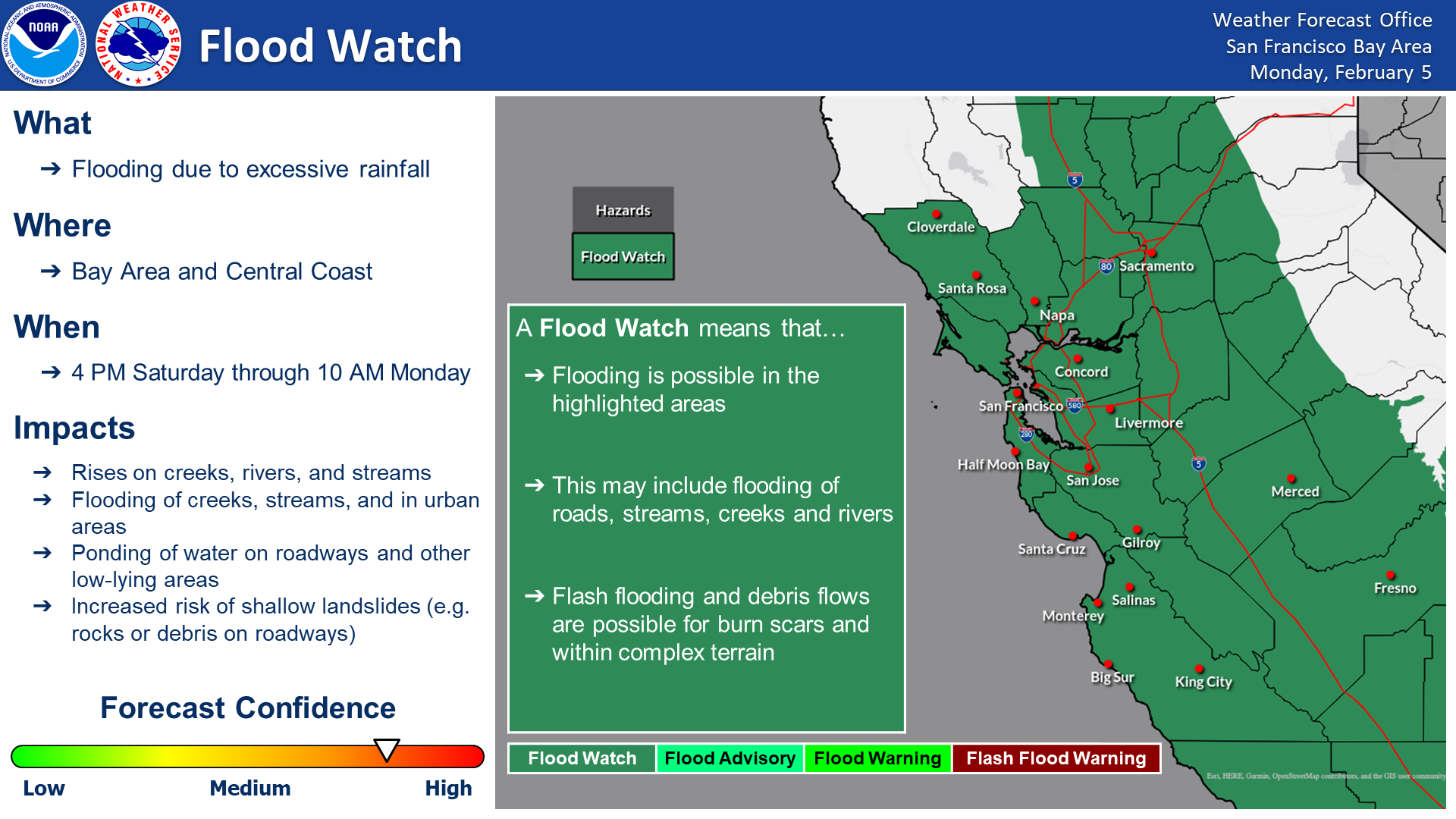
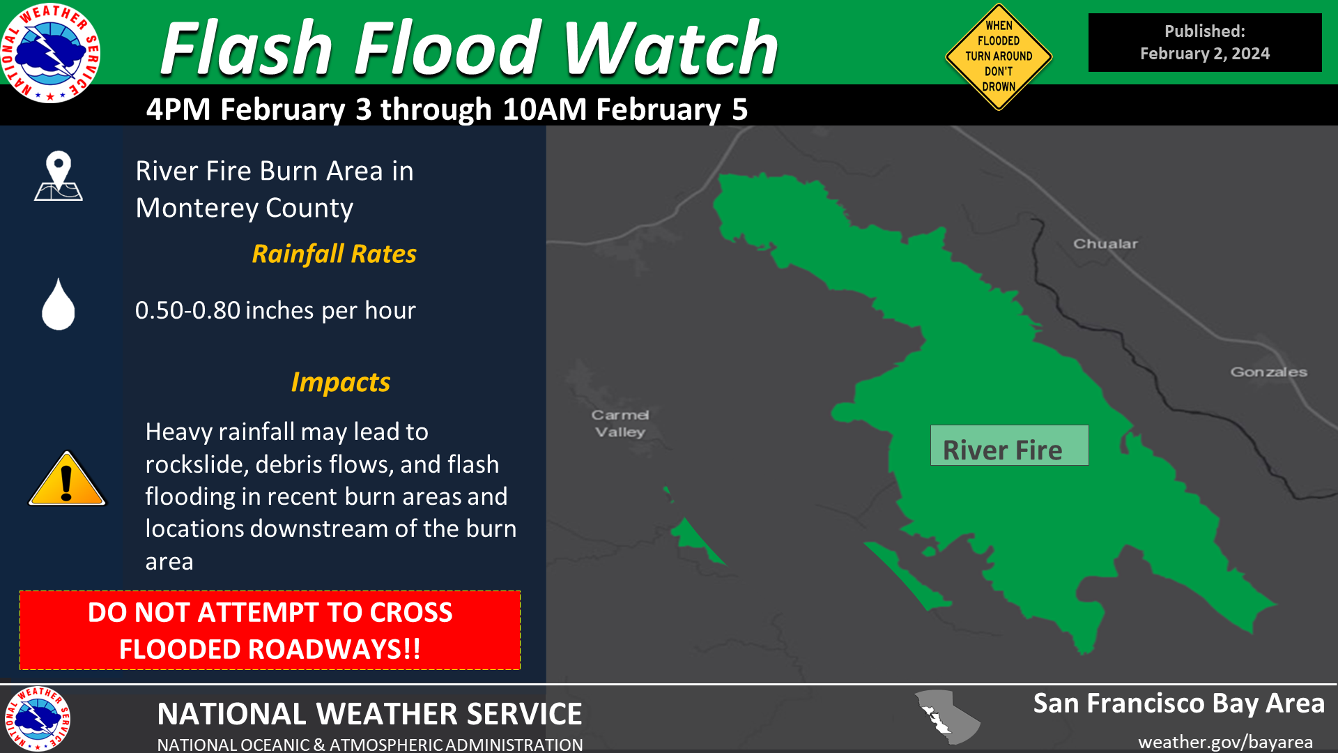
Flooding and Heavy Rain
Ample moisture streaming in from the tropics combined with orographic lifting led to a period of moderate to heavy rainfall. The more intense period of rainfall quickly overwhelmed smaller watersheds leading to flooding of some creeks/stream. Given the saturated soils landslides occurred as well.
 |
 |
 |
|
Weather Prediction Center - Excessive Rainfall Outlook showing a Moderate Risk of flash flooding |
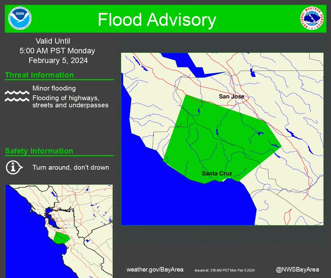
Given already saturated soils a Flood Watch was issued leading up to the event. |
With the possibility of high rainfall rate a Flash Flood Watch was issued for the River Burn Area. |
 |
 |
|
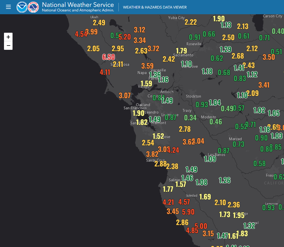
| One of many Flood Advisories issued due to minor flooding. | Rainfall amounts from Feb 3 - Feb 5. |
..TIME...   ...EVENT...      ...CITY LOCATION...     ...LAT.LON...
..DATE...   ....MAG....      ..COUNTY LOCATION..ST.. ...SOURCE....
            ..REMARKS..

0812 PM     Flood            2 SSW Live Oak          36.96N 121.99W
02/04/2024                   PZZ535             CA   Law Enforcement

            Roadway flooding near E Cliff Dr. / 9th Ave,
            expect some closures.

1100 AM     Flood            1 WSW Forestville       38.48N 122.91W
02/04/2024                   Sonoma             CA   Emergency Mngr

            Green Valley Creek at Martinelli Road has
            gone outside its boundaries and causing
            flooding. Per Sonoma Co DEM. Time is
            approximate.

0935 AM     Flood            3 SSW San Jose          37.27N 121.86W
02/04/2024                   Santa Clara        CA   Law Enforcement

            Lane #3 completely flooded along SR 87 NB.

0428 PM     Flood            3 ENE Santa Clara       37.38N 121.91W
02/04/2024                   Santa Clara        CA   Law Enforcement

            Roadway flooding near Junction Ave.

1014 PM     Flood            355 Convention Way      37.50N 122.23W
02/03/2024                   San Mateo          CA   Law Enforcement

            Roadway flooding.

0841 PM     Flood            2 S Colma               37.65N 122.45W
02/04/2024                   San Mateo          CA   Law Enforcement

            Roadway flooding near I280 S/Westborough
            Blvd Ofr.

0941 PM     Flood            I280S/Cesar Chavez St W 37.75N 122.39W
02/03/2024                   San Francisco      CA   Law Enforcement

            6 inches of standing water in slow lane.

0417 PM     Flood            6 SE Hollister          36.79N 121.32W
02/04/2024                   San Benito         CA   Law Enforcement

            Creek is running over into the road near
            Southside Rd/Sr25.

0842 PM     Flood            US 101N/Hartnell Rd     36.63N 121.58W
02/03/2024                   Monterey           CA   Law Enforcement

            101 N from Hartnell Rd to Alisal Rd closed
            due to flooding.

1057 AM     Flood            4 SE Greenfield         36.29N 121.19W
02/04/2024                   Monterey           CA   Law Enforcement

            Flooding in the low section of SB 101 across
            lane #2.

1145 AM     Flood            2 WNW Carmel Valley Vil 36.50N 121.75W
02/04/2024                   Monterey           CA   Law Enforcement

            Live Oak Ln - Roadway under water.

0138 PM     Flood            1 SSW Salinas           36.67N 121.64W
02/04/2024                   Monterey           CA   Law Enforcement

            Lanes closed due to flooding near W Carmel
            Valley road.

0912 PM     Flood            1 E Monterey            36.60N 121.87W
02/04/2024                   Monterey           CA   Law Enforcement

            Roadway flooding under overpass near Fremont
            St.

1201 AM     Flood            53 San Clemente Dr      37.93N 122.51W
02/04/2024                   Marin              CA   Law Enforcement

            Roadway flooding.

0331 AM     Flood            NB 101/Francisco Blvd O 37.96N 122.51W
02/04/2024                   Marin              CA   Law Enforcement

            Large amount of water in the #2 lane.

1119 PM     Flood            2434 Whipple Rd         37.61N 122.06W
02/03/2024                   Alameda            CA   Law Enforcement

            Roadway flooding SB 238 lane #3.

1122 PM     Flood            4999 Gleason Dr         37.72N 121.88W
02/03/2024                   Alameda            CA   Law Enforcement

            Roadway flooding.

1127 PM     Flood            SB 680 to EB 580 connec 37.71N 121.91W
02/03/2024                   Alameda            CA   Law Enforcement

            All lanes starting to flood.

1217 AM     Flood            I238 S/Hesperian Blvd O 37.69N 122.13W
02/04/2024                   Alameda            CA   Law Enforcement

            Slow lane flooded.

0116 AM     Flood            3601 Telegraph Ave      37.83N 122.27W
02/04/2024                   Alameda            CA   Law Enforcement

            Roadway flooding EB 80 just west of hilltop.

0132 AM     Flood            SB 680 to EB 580 connec 37.70N 121.92W
02/04/2024                   Alameda            CA   Law Enforcement

            #2 lane flooded, #1 lane half flooded.

0344 AM     Flood            I880S/High St offramp   37.78N 122.23W
02/04/2024                   Alameda            CA   Law Enforcement

            Flooding across all lanes.

0819 PM     Landslide        1500 Trinity Rd         38.40N 122.48W
02/04/2024                   Sonoma             CA   Law Enforcement

            Rockslide blocking EB lane, several branches
            2 inches in diameter blocking WB lane.

0906 PM     Landslide        SR128/Hogwarts Way      38.83N 123.04W
02/04/2024                   Sonoma             CA   Law Enforcement

            Slide blocking EB lanes.

0623 PM     Landslide        3 NE Santa Rosa         38.48N 122.66W
02/05/2024                   Sonoma             CA   Law Enforcement

            Mud slide blocking one lane of traffic near
            Calistoga Rd and Maria Carrillo High School.

1042 PM     Landslide        SR128/Lower Chiles Vall 38.51N 122.30W
02/04/2024                   Napa               CA   Law Enforcement

            Mudslide partially blocking west side of
            SR128 just west of Lower Chiles Valley Rd by
            a quarter of a mile. Rocks moved out of the
            roadway, there is still mud 1 foot past the
            line of the lane.

1215 AM     Landslide        NB Silverado Trail/Duna 38.58N 122.55W
02/05/2024                   Napa               CA   Law Enforcement

            Large mudslide at NB Silverado Trail just
            south of Dunaweal Lane with a mixture of
            rock, mud, and bushes blocking one lane.

0920 AM     Landslide        4 SE Del Monte Forest   36.54N 121.91W
02/04/2024                   Monterey           CA   Law Enforcement

            Slide in NB lane.

1119 AM     Landslide        3 NW Carmel Valley Vill 36.51N 121.77W
02/04/2024                   Monterey           CA   Law Enforcement

            Tree and slide blocking roadway at Rancho
            Fiesta Rd/Miramonte Rd.

&&

$$
|
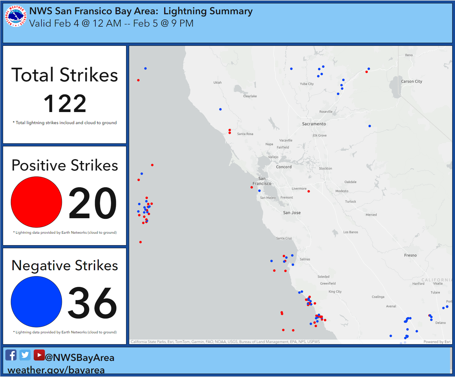
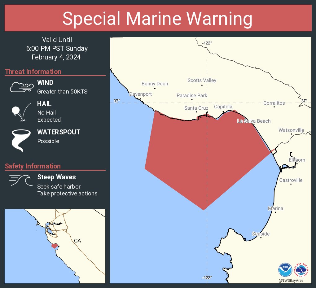
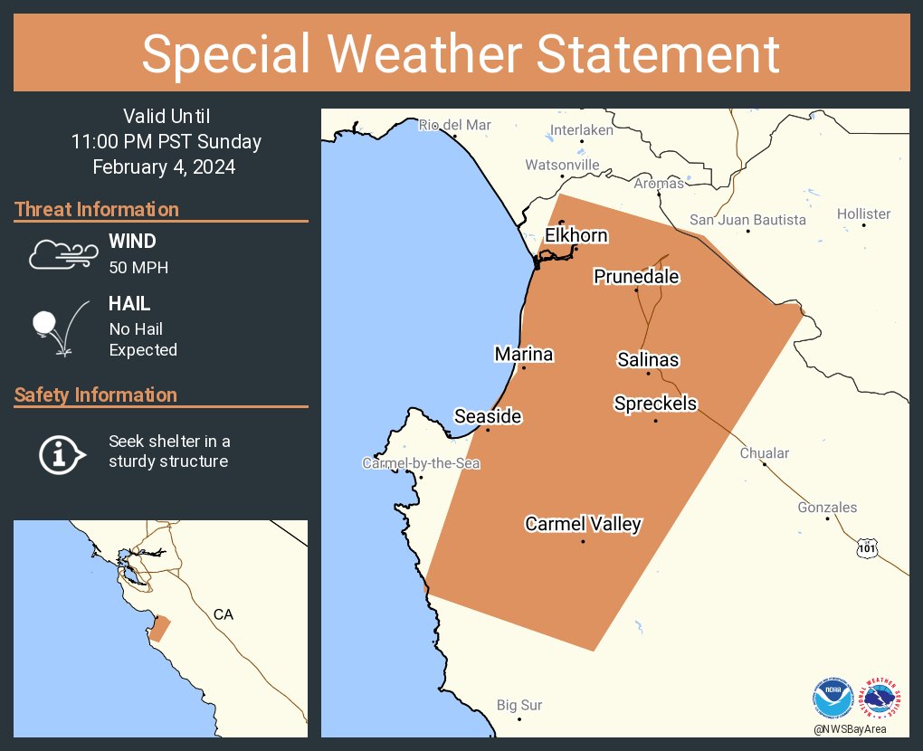
Convective Environment
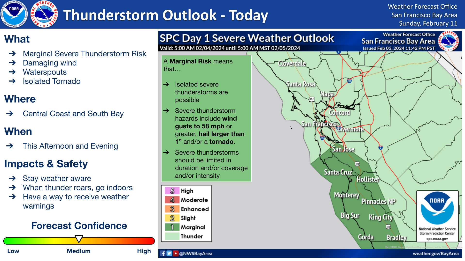
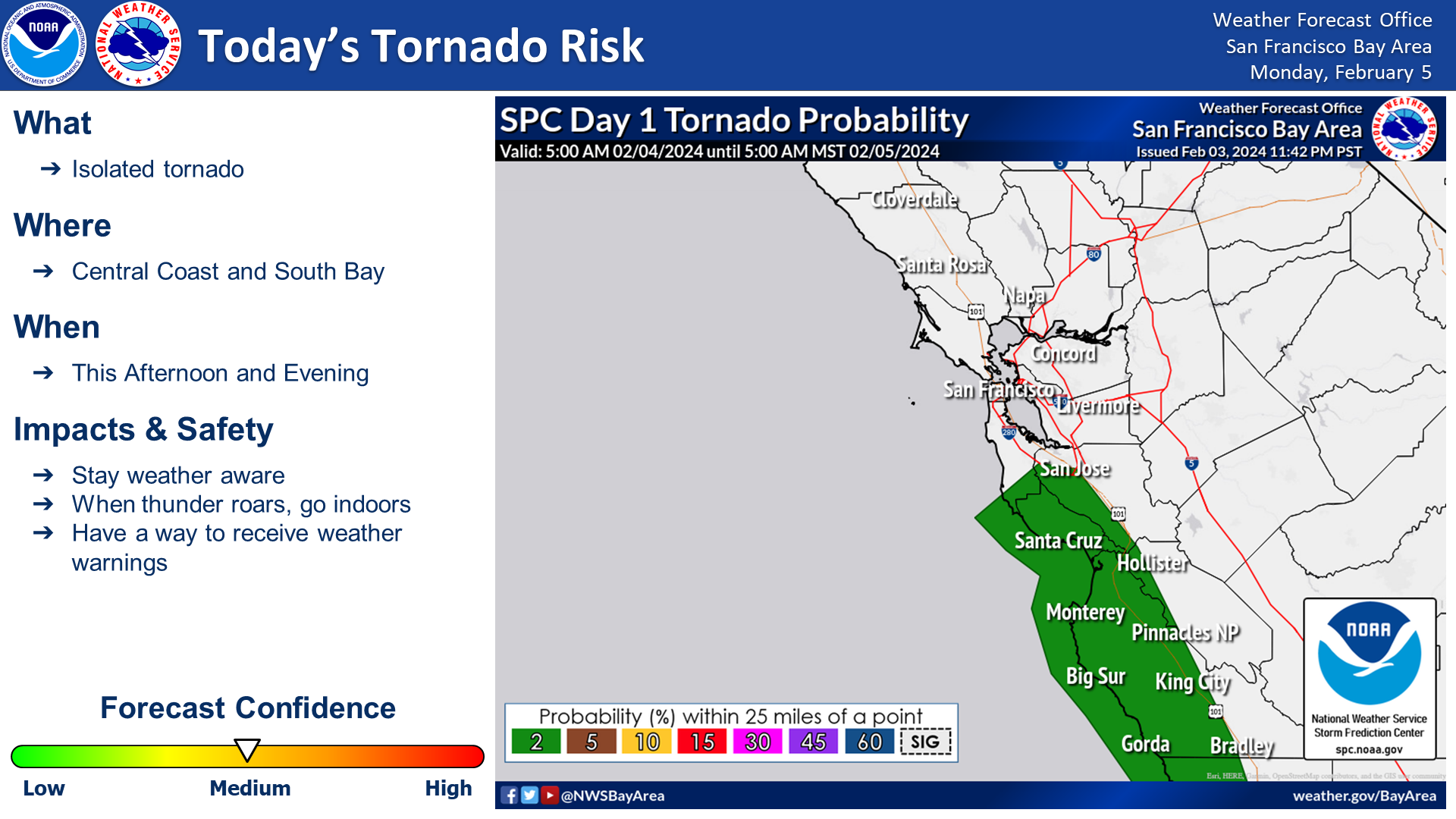
The intense low pressure along the coast combined with cold air aloft set the stage for a rather unstable environment. It's not uncommon for the Bay Area and Central Coast to be included in a general mention for thunderstorms, but for the Storm Prediction Center to include the Central Coast in a Marginal Risk is more rare. In fact, SPC even had a 2% chance for tornadoes. Fortunately, no tornadoes were reported, but funnel clouds and stronger showers were observed.
 |
 |
 |
|
Marginal Risk for Severe Thunderstorms. Doesn't happen very often. |
Rare tornado threat included for portions of the Central Coast. |
Lightning summary map. |
 |
 |
|
|
Intense thunderstorms led to numerous Special Marine Warnings being issued. Some stronger cells showed signs of rotation/possible waterspouts. |
One of many Special Weather Statements highlighting intense convective showers. |
|
 |
Media use of NWS Web News Stories is encouraged! Please acknowledge the NWS as the source of any news information accessed from this site. |
|