Dangerous and extreme heat will remain across portions of the southern U.S. this week. Heavy rainfall may bring significant flash flooding across portions of the Mid-Atlantic and Northeast through the night, and additional flash flooding concerns across New England on Wednesday. Monsoonal thunderstorms will bring a flash flood risk to the Four Corners region, especially in burn scar areas Read More >
Overview - Atmospheric River - November 20-23, 2024
Early Season Atmospheric River Brought Record Breaking Rains and Strong Winds to the Bay Area
|
Event Highlights
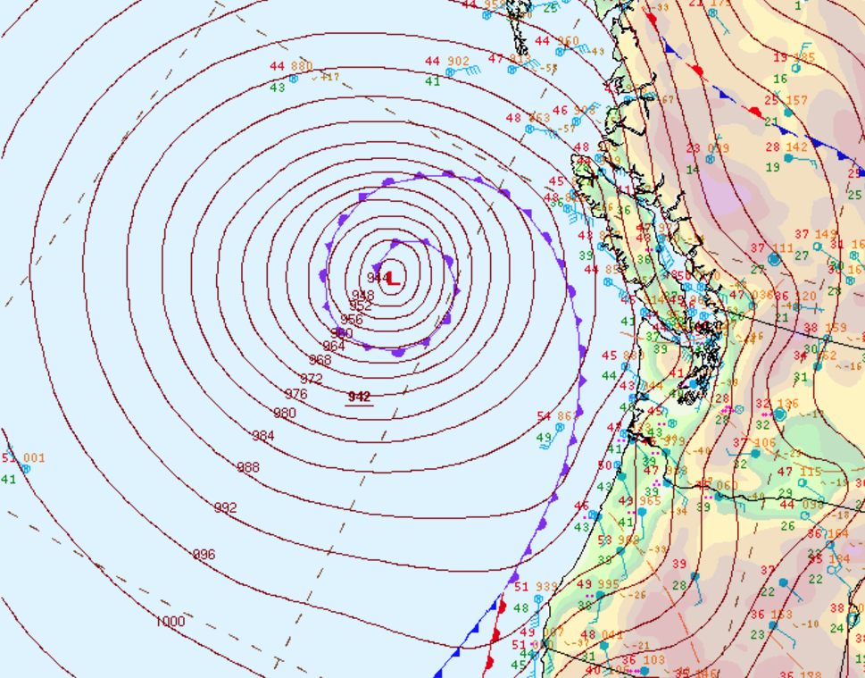
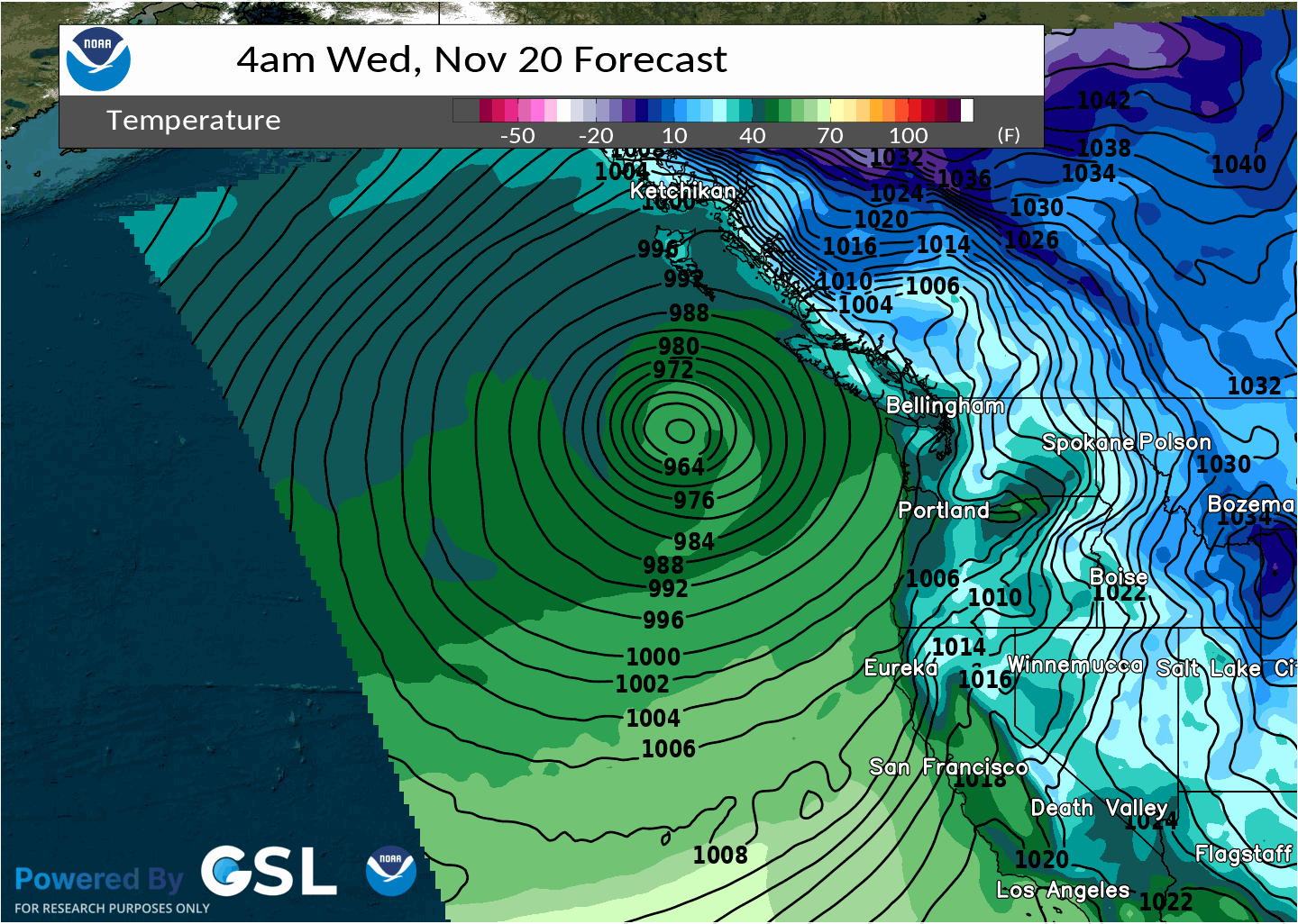
The first major storm to impact Northern California this season brought a meteorological trifecta: a bomb cyclone, an Atmospheric River, and the Fujiwhara Effect. These aren't "buzz weather terms", but real meteorological terminology. View the tabbed sections below to see impacts and other notable items with this event.
Composed by: MMehle
|
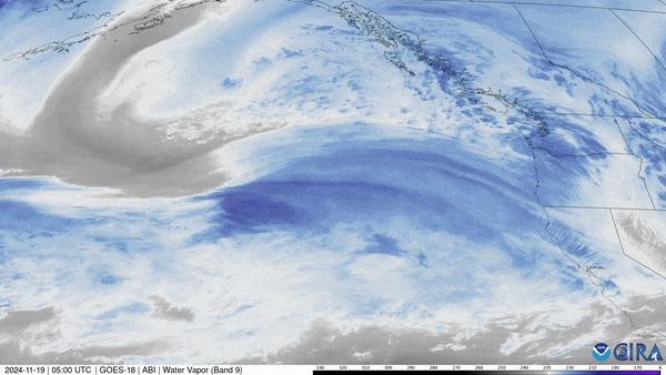
Satellite loop showing Bomb Cyclone off the Pac NW Coast. (Credit CSU/CIRA & NOAA)
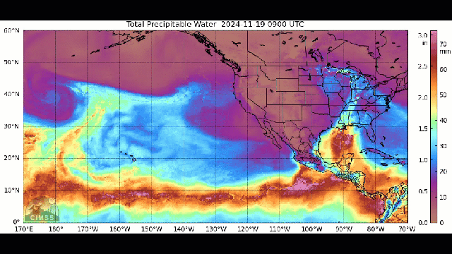
Atmospheric River taking aim at the West Coast. (Credit Wisc SECC)
Computer model simulating the Fujiwhara Effect off the PacNW Coast as two low pressure systems rotate around a central point. |
Radar - Heavy Rain
Rain started to enter the North Bay shortly after midnight on November 20. A few hours later, the heavier rainfall kicked in and continued off and on for the next 72 hours. The most intense rainfall impacted the North Bay through 48 hours and then spread southward impacting San Francisco Bay and the Central Coast. Higher elevations of the coastal North Bay received nearly two feet of rainfall, with most inland areas of the North Bay receiving 5-15 inches of rain. Elsewhere around the Bay Area and Central Coast measured 1-8 inches of rainfall.
 |
| Radar Loop of the entire event. |
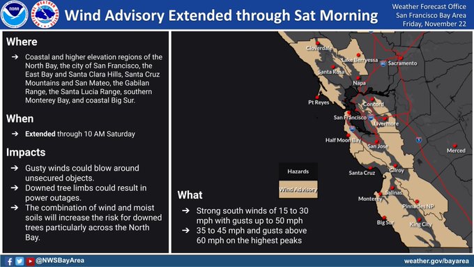
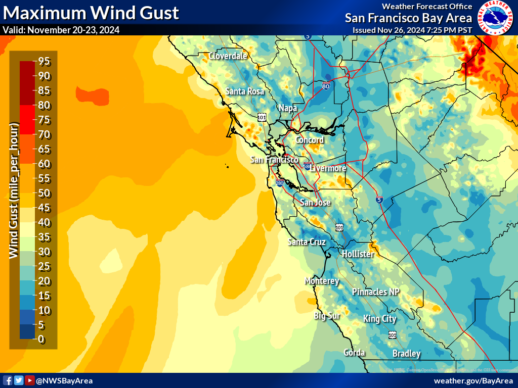
Gusty Southerly Winds
As the potent low pressure deepened over the Northeast Pacific the pressure gradient over land tightened leading to strong and gusty south-southwesterly winds. Winds were at their strongest over the coastal waters, coastline, and higher peaks around the region. The strongest winds peak between 60-80 mph. Needless to say, the strong winds caused some tree damage.
 |
 |
|
Wind Advisory issued for the portions Bay Area and the Central Coast. |
AR peak wind gusts. |
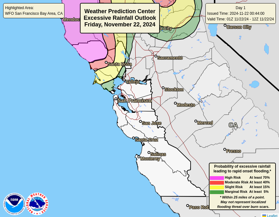
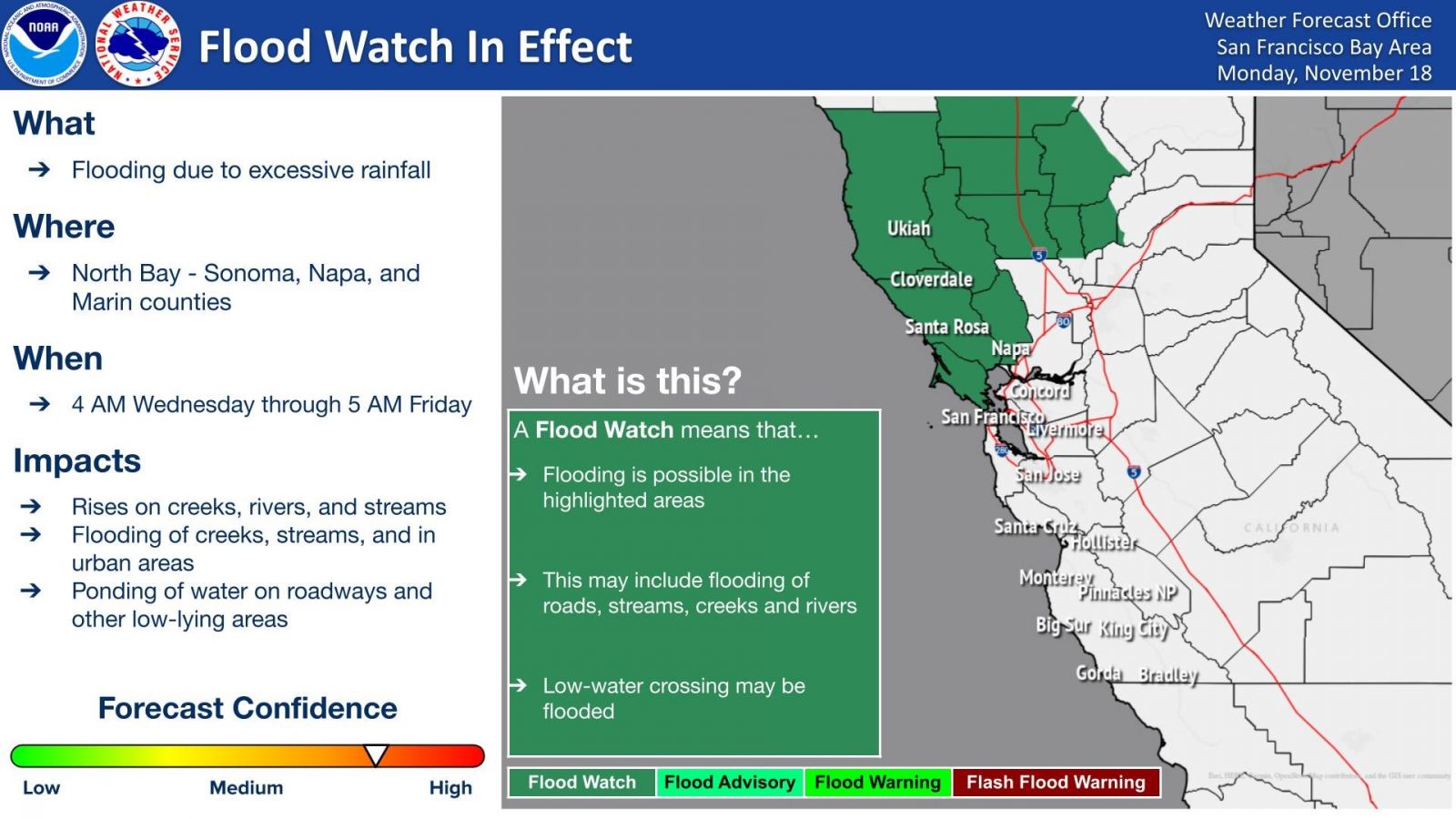
Flooding
Leading up to the event confidence increased that flooding would be more of a concern. As such, a Flood Watch was issued. The Weather Prediction Center also issued numerous Excessive Rainfall Outlooks (EROs) to highlight flooding potential. As the super moisture Atmospheric River began to interact with large scale ascent and topographical features rainfall quickly piled up. Numerous automated sensors reported Heavy Rain. Despite soil moisture content being relatively low prior to the event the soil quickly became overwhelmed leading to flooding, especially the North Bay. Once the smaller creeks and streams were full the larger scale rivers began to fill leading to Flood Warnings for the Russian River. Lastly, rainfall rates were so high at one point urban areas couldn't handle the runoff leading to Flash Flood Warnings. Sadly, one person lost their life to flooded roadways.
 |
 |
| Rare Day 1 Excessive Rainfall Outlook via WPC | Meso-scale Discussion highlighting flooding threat |
 |
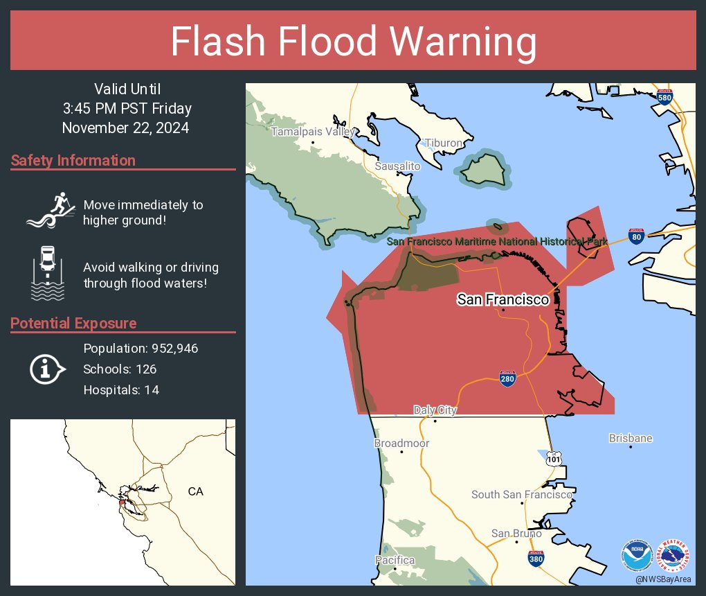 |
| Flood Watch issued for the North Bay | Flash Flood Warning issued for San Francisco |
 |
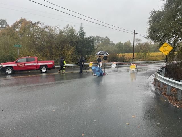 |
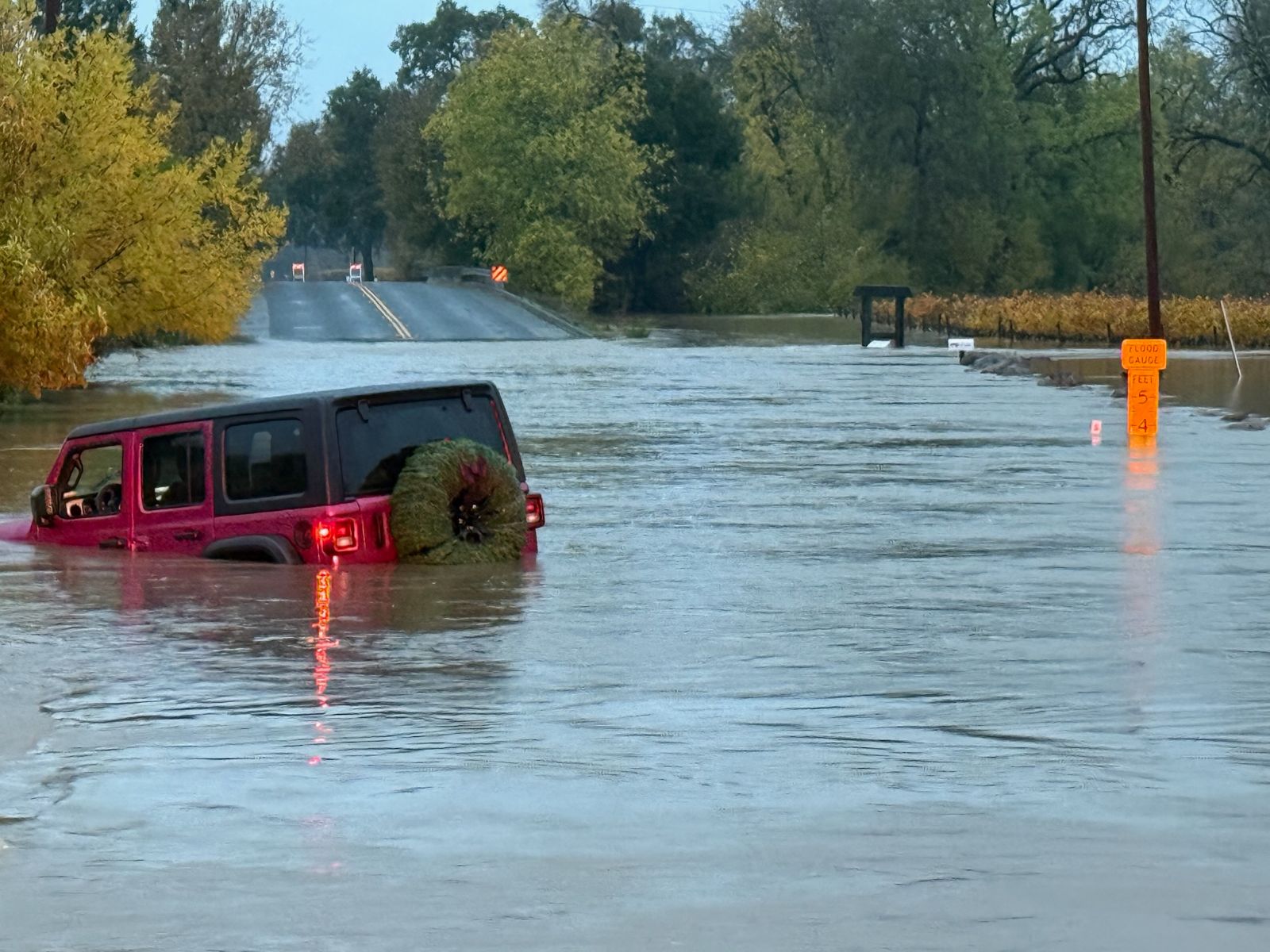
| Flooded Jeep - Photo by Jeff DuVall (Sonoma Cty) | Mark West Creek Road Closure |
Storm reports
Given the very dynamic meteorological event it shouldn't be surprising that damage reports were received, whether it be downed trees, flooded roads, or very strong gusts. Here's a list of reports we received.
Preliminary Local Storm Report...Summary
National Weather Service San Francisco CA
1125 PM PST Sat Nov 23 2024
..TIME... ...EVENT... ...CITY LOCATION... ...LAT.LON...
..DATE... ....MAG.... ..COUNTY LOCATION..ST.. ...SOURCE....
..REMARKS..
0254 PM Non-Tstm Wnd Dmg 36 SW El Granada 37.19N 122.99W
11/22/2024 PZZ575 CA Law Enforcement
Tree branch in right lane at SR 17N and Bear
Creek Road Offramp.
0811 AM Flood 1 W Rohnert Park 38.35N 122.72W
11/20/2024 Sonoma CA Law Enforcement
Roadway Flooding at 6100 Labath Ave.
0828 AM Flood 2 E Healdsburg 38.61N 122.83W
11/20/2024 Sonoma CA Law Enforcement
Mud/Dirt/Rock on Camp Rose Rd / S Fitch
Mountain Rd.
1156 AM Flood 3 NE Forestville 38.51N 122.84W
11/20/2024 Sonoma CA County Official
Roadway flooding - Mark West Station Road
and Starr Road closed due to flooding.
0130 PM Flood 3 SW Windsor 38.51N 122.84W
11/20/2024 Sonoma CA Emergency Mngr
Mark West Station Road now closed.
0148 PM Non-Tstm Wnd Dmg 2 NNW Occidental 38.42N 122.95W
11/20/2024 Sonoma CA Law Enforcement
Tree down blocking roadway at Bohemian
Highway and Hampton Road.
0200 PM Flood South Santa Rosa 38.41N 122.72W
11/20/2024 Sonoma CA Emergency Mngr
minor flooding occurring along Colgan creek
on Ohair Ct and west of Stoney point rd.
https://maps.app.goo.gl/hSBRtaDmhNzaWLDm9.
0200 PM Flood 3 SSE Larkfield-Wikiup 38.48N 122.74W
11/20/2024 Sonoma CA Emergency Mngr
Flooding along piner creek on Industrial Dr
between Airway Dr and Cleveland Ave and
Cleveland Ave is shut down.
https://maps.app.goo.gl/maFZhfEXwDNN31aN9.
0246 PM Landslide 2 ENE Larkfield-Wikiup 38.52N 122.72W
11/20/2024 Sonoma CA Law Enforcement
Landslide blocking west bound lanes at Mark
West Springs Road / Redwood Hill Road.
0316 PM Flood 2 ENE Forestville 38.50N 122.86W
11/20/2024 Sonoma CA County Official
Roadway flooding - Trenton Healdsburg Road
closed between Mark West Station Road and
River Road due to flooding.
0341 PM Non-Tstm Wnd Dmg 2 N Forestville 38.51N 122.89W
11/20/2024 Sonoma CA Law Enforcement
Tree down blocking all lanes near Westside
Road and Wohler Road.
0601 PM Landslide 1 NNE Guerneville 38.52N 122.98W
11/20/2024 Sonoma CA Law Enforcement
Mud/Dirt/Rock blocking west bound lanes near
River Road and Canyon Seven Road.
0835 PM Non-Tstm Wnd Dmg 3 NW Cloverdale 38.83N 123.05W
11/20/2024 Sonoma CA Law Enforcement
Tree approximately 4-6 feet long covering
both EB/WB lanes at SR 128 just west of
Hogwarts.
1235 AM Landslide 4 WSW Calistoga 38.55N 122.65W
11/21/2024 Sonoma CA Law Enforcement
Mud/dirt/rocks blocking roadway on Porter
Creek Rd, per CHP.
1255 AM Flood 1 WNW Rohnert Park 38.35N 122.72W
11/21/2024 Sonoma CA Law Enforcement
Roadway flooding at 6100 Labath Ave.
0108 AM Flood 1 W Rohnert Park 38.35N 122.72W
11/21/2024 Sonoma CA Law Enforcement
Minor roadway flooding near Rohnert Park
Expy and Labath Ave, per CHP.
0739 AM Flood 3 SSW Windsor 38.51N 122.83W
11/21/2024 Sonoma CA County Official
Slusser Road closed due to flooding between
Laughlin Road and River Road.
0742 AM Non-Tstm Wnd Dmg 3 SE Monte Rio 38.44N 122.97W
11/21/2024 Sonoma CA Law Enforcement
Road Closure at 5549 Bohemian Hwy - PG&E HAS
HARD CLOSURE IN PLACE FOR MULTIPLE TREES
DOWN // TILL APPROX 1732.
0752 AM Flood 3 E Forestville 38.49N 122.83W
11/21/2024 Sonoma CA Newspaper
A driver escaped rising flood waters on
Slusser roads in Santa Rosa. Sonoma County
Fire District spokeswoman Karen Hancock told
KTVU that the driver decided to drive
through the deep water at River and Slusser
roads despite flood warnings not to do so.
https://www.ktvu.com/news/driver-escapes-rising-santa-rosa-flooding-water.
0757 AM Landslide 4 NNE Healdsburg 38.67N 122.82W
11/21/2024 Sonoma CA Law Enforcement
SR128 / Alexander Valley Rd- HILLSIDE HAS
COLLAPSED INTO THE NB LANES AND BLKG NB
LANES.
0759 AM Landslide 4 NW Cloverdale 38.84N 123.06W
11/21/2024 Sonoma CA Law Enforcement
ROCK SLIDE BLOCKING EB LANE (33606-37385
Sr128).
0928 AM Flood 2 SW South Santa Rosa 38.39N 122.74W
11/21/2024 Sonoma CA County Official
Todd Road closed due to flooding between Old
Gravenstein Highway and Llano Road.
0951 AM Non-Tstm Wnd Dmg 2 NNE Glen Ellen 38.38N 122.52W
11/21/2024 Sonoma CA County Official
Henno Road Closed due to Downed Powerline.
0957 AM Non-Tstm Wnd Dmg 15 WNW Monte Rio 38.54N 123.28W
11/21/2024 Sonoma CA County Official
Timbercove Road closed due to downed tree.
1022 AM Flood 3 E Santa Rosa 38.45N 122.65W
11/21/2024 Sonoma CA County Official
Spring Lake Regional Park is closed due to
flooding in the area.
1029 AM Flood 3 N Healdsburg 38.65N 122.87W
11/21/2024 Sonoma CA County Official
Lytton Station Road closed between
Healdsburg Avenue and Alexander Valley Road
due to flooding.
1201 PM Flood 2 S Windsor 38.52N 122.80W
11/21/2024 Sonoma CA County Official
Skylane Boulevard closed between Aviation
Boulevard and Kittyhawk Boulevard due to
flooding.
1204 PM Flood 2 NE Forestville 38.50N 122.86W
11/21/2024 Sonoma CA County Official
Eastside Road closed between Trenton
Healdsburg Road and Windsor River Road due
to flooding.
1205 PM Non-Tstm Wnd Dmg 5 NW Monte Rio 38.51N 123.08W
11/21/2024 Sonoma CA County Official
4200 Austin Creek Road closed due to downed
tree.
1207 PM Landslide 3 NE Larkfield-Wikiup 38.55N 122.72W
11/21/2024 Sonoma CA County Official
Road closure at Porter Creek Road and Mark
West Springs Road due to landslide.
1230 PM Flood 3 E Forestville 38.49N 122.83W
11/21/2024 Sonoma CA Public
Roadway flooding-Really bad spot on River at
Slusser ditch overflowing water is pretty
deep in the eastbound lane. Could become a
problem for our crews heading in later in
the day.
1230 PM Flood 3 WSW Larkfield-Wikiup 38.49N 122.80W
11/21/2024 Sonoma CA Emergency Mngr
Roadway Flooding- River Road west of
Laughlin has several overflowing ditches
that at some point may become impassable the
water is out on the road.
1230 PM Flood 1 SW Larkfield-Wikiup 38.50N 122.77W
11/21/2024 Sonoma CA Emergency Mngr
Roadway flooding. Fulton at Spring Hills
Church (north of River Rd) ditches are
flooding over the roadway. It is passable
but getting worse.
1240 PM Flood 4 ENE Graton 38.47N 122.80W
11/21/2024 Sonoma CA County Official
Piner Road closed due to flooding between
Olivet Road and Willowside Road.
0100 PM Flood 1 SSE Windsor 38.53N 122.79W
11/21/2024 Sonoma CA Emergency Mngr
Northbound Shiloh exit in Sonoma County has
been closed by CHP due to water on road, as
reported on the SoCo OA call.
0115 PM Flood 3 NE Larkfield-Wikiup 38.55N 122.72W
11/21/2024 Sonoma CA Fire Dept/Rescue
Mark West Springs Road has a hard closure,
7-10 water rescue events so far per SoCo
Fire.
0121 PM Landslide 7 N Guerneville 38.61N 123.01W
11/21/2024 Sonoma CA County Official
Water district reports 15.71 inches of rain
over the last 48 hours for the Venado rain
gage with mud/landslides impaciting Mill
Creek Rd.
0143 PM Flood 3 ENE Graton 38.46N 122.81W
11/21/2024 Sonoma CA County Official
Willowside Road closed between Guerneville
Road and Piner Road due to Flooding.
0146 PM Flood 3 NW Cloverdale 38.84N 123.05W
11/21/2024 Sonoma CA Law Enforcement
Mud/Dirt/Rock in Roadway at 258 Mm128 W Son
2.60.
0255 PM Flood 2 ENE Forestville 38.49N 122.86W
11/21/2024 Sonoma CA County Official
Trenton Healdsburg Road is closed at River
Road due to flooding.
0307 PM Flood 2 W Rohnert Park 38.35N 122.74W
11/21/2024 Sonoma CA County Official
Rohnert Park Expressway is closed at Stony
Point Road due to flooding.
0613 PM Flood 3 WNW Rohnert Park 38.36N 122.74W
11/21/2024 Sonoma CA Law Enforcement
Sedan stuck in flood waters on Wilfred Ave
at Stony Point Road, being pushed towards
Rohnert Park.
0903 PM Flood 1 NNE Forestville 38.49N 122.88W
11/21/2024 Sonoma CA County Official
Wohler Road is closed between River Road and
Eastside Road due to flooding.
0921 PM Flood 2 E Healdsburg 38.62N 122.83W
11/21/2024 Sonoma CA Law Enforcement
Flooding under Fitch Mountain Road at
Hilltop Road.
0922 PM Flood 1 ESE Larkfield-Wikiup 38.51N 122.73W
11/21/2024 Sonoma CA Law Enforcement
Boulder on Mark West Springs Road at
Quietwater Road, blocking both lanes.
0936 PM Flood 2 ENE Sebastopol 38.41N 122.79W
11/21/2024 Sonoma CA Law Enforcement
Flooding on both sides on Llano Road at
State Route 12.
1030 PM Non-Tstm Wnd Gst 7 NNW Calistoga 38.67N 122.63W
11/21/2024 M60 MPH Sonoma CA Mesonet
Mesonet station PG132 Mt St Helena.
1030 PM Non-Tstm Wnd Gst 11 E Cloverdale 38.82N 122.81W
11/21/2024 M65 MPH Sonoma CA Mesonet
Mesonet station PG125 Cobb Ridge West.
1042 PM Non-Tstm Wnd Gst 2 N Healdsburg 38.65N 122.87W
11/21/2024 E17 MPH Sonoma CA County Official
Lanes on Alexander Valley Road between
Healdsburg Avenue and Buni Road closed due
to a downed tree.
1250 AM Non-Tstm Wnd Gst 11 E Cloverdale 38.82N 122.81W
11/22/2024 M65 MPH Sonoma CA Mesonet
Mesonet station PG125 Cobb Ridge West.
0300 AM Non-Tstm Wnd Gst 7 NNW Calistoga 38.67N 122.63W
11/22/2024 M63 MPH Sonoma CA Mesonet
Mesonet station PG132 Mt St Helena.
0413 AM Flood 3 SSE Sonoma 38.25N 122.44W
11/22/2024 Sonoma CA Law Enforcement
CHP reports 6-8 inches of standing water on
the roadway.
0947 AM Landslide 4 NW Glen Ellen 38.39N 122.59W
11/22/2024 Sonoma CA Law Enforcement
Boulders/rockslide blocking northbound
roadway at Bennett Ridge Road and Bennett
Valley Road.
1105 AM Landslide 3 ESE Rohnert Park 38.34N 122.65W
11/22/2024 Sonoma CA Law Enforcement
Rockslide blocking roadway near Lichau Road
and Roberts Road.
1107 AM Non-Tstm Wnd Dmg 2 NNW Forestville 38.50N 122.90W
11/22/2024 Sonoma CA Law Enforcement
Downed tree and power lines in roadway at
Westside Road and Wohler.
1108 AM Landslide 4 WSW Calistoga 38.55N 122.65W
11/22/2024 Sonoma CA Law Enforcement
Rocks and debris blocking both lanes at
Porter Creek Road and Calistoga Road.
1133 AM Landslide 5 SW Calistoga 38.53N 122.65W
11/22/2024 Sonoma CA Law Enforcement
Rockslide reported in SB lane at 3156
Calistoga Road.
1138 AM Non-Tstm Wnd Dmg 1 ENE Glen Ellen 38.36N 122.53W
11/22/2024 Sonoma CA Law Enforcement
Downed tree and power lines reported at
Arnold Drive and Chauvet Road.
1204 PM Flood Glen Ellen 38.36N 122.53W
11/22/2024 Sonoma CA Law Enforcement
Roadway flooding reported.
1241 PM Landslide 1 NW Larkfield-Wikiup 38.53N 122.76W
11/22/2024 Sonoma CA Law Enforcement
Mudslide blocking roadway.
0151 PM Flood 1 ESE El Verano 38.29N 122.48W
11/22/2024 Sonoma CA Law Enforcement
Roadway flooding reported.
0156 PM Flood 2 ENE Forestville 38.49N 122.86W
11/22/2024 Sonoma CA Law Enforcement
Flooding across both sides of roadway at
Trenton Healdsburg Road and River Road.
0441 PM Flood 2 NE Forestville 38.50N 122.86W
11/22/2024 Sonoma CA Law Enforcement
Roadway flooding report at 5535 Eastside
Road. Vehicle unable to drive out of water.
0442 PM Flood 3 E Forestville 38.48N 122.83W
11/22/2024 Sonoma CA Law Enforcement
Roadway flooding reported between River Road
and Slusser Road.
0513 PM Flood 2 NW Rohnert Park 38.36N 122.72W
11/22/2024 Sonoma CA Law Enforcement
Roadway flooding reported between Wilfred
Ave/Labath Ave Report indicated that
vehicles will get stuck if attempted to
drive through.
0627 PM Flood 3 N Healdsburg 38.66N 122.85W
11/22/2024 Sonoma CA Law Enforcement
Vehicle stuck in 3 feet of water on
Alexander Valley Road at Lytton Station
Road.
0828 PM Flood 4 NE Santa Rosa 38.49N 122.66W
11/22/2024 Sonoma CA Law Enforcement
Slide covering half of Calistoga Road north
of Harville Road.
1025 PM Flood 4 NE Healdsburg 38.67N 122.82W
11/22/2024 Sonoma CA Law Enforcement
Vehicle stuck in floodwaters on Alexander
Valley Road west of the junction with State
Route 128.
1049 PM Flood 5 S Occidental 38.32N 122.93W
11/22/2024 Sonoma CA Law Enforcement
Flooding in the westbound and eastbound
lanes of Highway 1 at Valley Ford Freestone
Road.
0841 PM Flood 3 ENE Boulder Creek 37.16N 122.08W
11/22/2024 Santa Cruz CA Law Enforcement
Rock slide blocking one lane of Bear Creek
Road just east of Hawk Ridge Road.
1121 PM Flood 2 NE Freedom 36.96N 121.76W
11/22/2024 Santa Cruz CA Law Enforcement
Roadway flooding reported at junction of
Green Valley Road and Paulsen Road.
0640 AM Flood 3 SSW Milpitas 37.39N 121.91W
11/20/2024 Santa Clara CA Law Enforcement
Roadway Flooding at 2020 Junction Ave.
0917 AM Flood 2 NNW San Jose 37.34N 121.86W
11/20/2024 Santa Clara CA Law Enforcement
Road Closure at Mclaughlin Ave Onramp of
I-280 for Drainage cleaning FROM 0915-1430
HOURS.
0150 PM Non-Tstm Wnd Dmg 1 NE Campbell 37.30N 121.94W
11/21/2024 Santa Clara CA Law Enforcement
PG&E WILL CLOSE OFR *** 1330-1700 HRS --.
0254 PM Non-Tstm Wnd Dmg 2 NNW Lexington Hills 37.19N 121.99W
11/22/2024 Santa Clara CA Law Enforcement
Corrects previous non-tstm wnd dmg report
from 36 SW El Granada. Tree branch in right
lane at SR 17N and Bear Creek Road Offramp.
0254 PM Non-Tstm Wnd Dmg 2 NNW Lexington Hills 37.19N 121.99W
11/22/2024 Santa Clara CA Law Enforcement
Corrects location of previous non-tstm wnd
dmg report from 36 SW El Granada. Tree
branch in right lane at SR 17N and Bear
Creek Road Offramp.
0840 PM Non-Tstm Wnd Gst 2 ENE Lexington Hills 37.17N 121.94W
11/22/2024 M65 MPH Santa Clara CA Mesonet
Mesonet station PG756 Soda Springs Road.
0900 PM Non-Tstm Wnd Gst 4 E Lexington Hills 37.16N 121.91W
11/22/2024 M58 MPH Santa Clara CA Mesonet
Mesonet station PG608 Mt. Umunhum.
0903 PM Flood Morgan Hill 37.13N 121.63W
11/22/2024 Santa Clara CA Law Enforcement
Vehicles hydroplaning on northbound US
Highway 101 north of Dunne Avenue.
0936 PM Flood 2 SSW Lexington Hills 37.15N 121.98W
11/22/2024 Santa Clara CA Law Enforcement
Standing water in both lanes of northbound
State Route 17 south of Summit Road.
1001 PM Flood 2 NNE Cupertino 37.33N 122.03W
11/22/2024 Santa Clara CA Law Enforcement
Two right lanes of northbound Interstate 280
at De Anza Blvd flooded.
0630 AM Flood 1 ESE Redwood City 37.50N 122.23W
11/20/2024 San Mateo CA Law Enforcement
Roadway Flooding 355 Convention Way.
0630 AM Flood 1 ESE Redwood City 37.50N 122.23W
11/21/2024 San Mateo CA Law Enforcement
Roadway flooding.
0919 AM Flood San Bruno 37.63N 122.43W
11/21/2024 San Mateo CA Law Enforcement
Roadway Flooding at NB 280 JSO SAN BRUNO
AVE. FLOODING ACROSS #1 LN / MULT TCS
ALREADY.
1137 AM Flood 1 SSW Daly City 37.68N 122.47W
11/22/2024 San Mateo CA Law Enforcement
Roadway flooding reported at SB280 and SB 1
intersection with 6 to 8 inches of water
across lanes.
1142 AM Flood Daly City 37.69N 122.47W
11/22/2024 San Mateo CA Law Enforcement
Flooding across all lanes including offramp
at I280N and Westlake Ave Offramp. Mud and
water flooding all lanes.
1240 PM Non-Tstm Wnd Gst 2 N Montara 37.57N 122.49W
11/22/2024 M69 MPH San Mateo CA Mesonet
Mesonet station 620PG North Peak Access
Road.
1250 PM Flood Daly City 37.69N 122.47W
11/22/2024 San Mateo CA Law Enforcement
Over 1 foot of water reported on I-280.
0226 PM Flood 2 NNW Montara 37.57N 122.52W
11/22/2024 San Mateo CA Law Enforcement
Roadway flooding with rocks and mud sliding
off hillside near Devils Slide and Tom
Lantos tunnel.
0237 PM Flood 2 WSW Colma 37.66N 122.48W
11/22/2024 San Mateo CA Law Enforcement
Law enforcement reported roadway flooding at
SR1 under Manor Drive.
0302 PM Flood 1 ENE Millbrae 37.60N 122.38W
11/22/2024 San Mateo CA Law Enforcement
Roadway flooding. 4 to 5 inches reported in
#7 lane.
0303 PM Flood 2 SW Pacifica 37.60N 122.50W
11/22/2024 San Mateo CA Law Enforcement
Roadway flooding reported between Montera
and Pacifica at SR 1 and Linda Mar
Boulevard.
0307 PM Flood 13 WNW Boulder Creek 37.18N 122.37W
11/22/2024 San Mateo CA Law Enforcement
Roadway flooding reported at SR 1 N just
north of Gazos Creek Road.
0326 PM Flood 3 SW Highlands 37.49N 122.39W
11/22/2024 San Mateo CA Law Enforcement
Roadway flooding reported at SR 92 W and
Pilarcitos Creek Road.
0341 PM Flood 1 ENE Millbrae 37.60N 122.38W
11/22/2024 San Mateo CA Law Enforcement
Roadway flooding reported at US 101 S and
Millbrae Avenue offramp. Reporting 1-2 feet
of water in lanes 5 to 6.
0621 PM Flood 1 SSW Daly City 37.67N 122.47W
11/22/2024 San Mateo CA Law Enforcement
Roadway flooding NB 280 to SB 1.
0826 PM Flood 1 SW Colma 37.66N 122.47W
11/22/2024 San Mateo CA Law Enforcement
Vehicle stuck in water in the HOV lane of
the onramp from Hickey Boulevard to
southbound Interstate 280.
0631 AM Flood 1 ENE San Francisco 37.78N 122.41W
11/20/2024 San Francisco CA Law Enforcement
Roadway Flooding at 455 8th St.
0631 AM Flood 1 E San Francisco 37.78N 122.41W
11/21/2024 San Francisco CA Law Enforcement
Roadway Flooding.
0900 AM Flood San Francisco 37.78N 122.42W
11/21/2024 San Francisco CA Emergency Mngr
Per DEM Call at 9 am 6 trees down yesterday,
all small and were sidewalk type trees,
cleared quickly and no injury or damage 12
catchment basins had some local flooding due
to debris (leaves), which were cleared
quickly and no damage was noted.
0957 AM Flood 1 SSE San Francisco 37.77N 122.42W
11/21/2024 San Francisco CA Emergency Mngr
Inflatable flood barrier has been deployed
at 17th and Folsom and will likely be out
through Friday into Saturday morning.
1131 AM Flood 3 NNE Daly City 37.72N 122.45W
11/22/2024 San Francisco CA Law Enforcement
Roadway flooding reported across across 280
onramp near Geneva Ave. Initial estimate of
6 to 7 inches.
1133 AM Flood 3 SSE San Francisco 37.74N 122.40W
11/22/2024 San Francisco CA Law Enforcement
Roadway flooding reported at I280 N and
Cesar Chavez Offramp. 4 to 6 inches in lanes
1 and 2.
0200 PM Flood 3 S San Francisco 37.73N 122.41W
11/22/2024 San Francisco CA Emergency Mngr
Emergency manager reported flooding at
Alemany Boulevard and Crescent Avenue. A
Flash Flood Warning was in effect at the
time.
0200 PM Flood 2 NNW San Francisco 37.81N 122.44W
11/22/2024 San Francisco CA Emergency Mngr
Emergency manager reported flooding at
Marina Green. A Flash Flood Warning was in
effect at the time.
0200 PM Flood 1 SSE San Francisco 37.76N 122.42W
11/22/2024 San Francisco CA Emergency Mngr
Emergency manager reported flooding at
corner of Folsom Street and 17th Street. A
Flash Flood Warning was in effect at this
time.
0212 PM Flood 1 ESE San Francisco 37.77N 122.40W
11/22/2024 San Francisco CA Public
Member of the public sent in photos and a
video on X showing flooding at the
intersection of Alameda St and Henry Adams
St in San Francisco. Photos show a car stuck
in the water and video shows water extending
up first step of a flight of stairs. A Flash
Flood Warning was in effect at the time.
0340 PM Flood 2 N Brisbane 37.72N 122.40W
11/22/2024 San Francisco CA Law Enforcement
Roadway flooding reported at US 101 S and
Paul Ave offramp. One foot rain in lanes 3
to 5.
0354 PM Flood 2 ESE San Francisco 37.76N 122.39W
11/22/2024 San Francisco CA Law Enforcement
Roadway flooding reported at I280 S and
Mariposa St onramp.
0402 PM Flood 2 SSE San Francisco 37.75N 122.40W
11/22/2024 San Francisco CA Law Enforcement
Roadway flooding reported in lanes 2, 3, and
4.
0509 PM Flood 3 SSE San Francisco 37.74N 122.40W
11/22/2024 San Francisco CA Law Enforcement
Roadway flooding reported at NB 280 just
north of Cesar Chavez street offramp.
0521 PM Flood 2 SE San Francisco 37.76N 122.39W
11/22/2024 San Francisco CA Law Enforcement
Roadway flooding with cars stuck in it
reported at NB 280 just south of Mariposa
street offramp.
0649 PM Flood 3 SSW San Francisco 37.73N 122.43W
11/22/2024 San Francisco CA Law Enforcement
Three vehicles stuck in water near I280 S/
Monterey Blvd.
0833 PM Flood 3 SSE San Francisco 37.74N 122.40W
11/22/2024 San Francisco CA Law Enforcement
Vehicle drove through water on the offramp
from Interstate 280 N to Cessar Chavez St
and stopped.
0426 AM Landslide 4 N Calistoga 38.64N 122.59W
11/21/2024 Napa CA Law Enforcement
CHP reports Mud/Dirt/Rock on the roadway
along SR29.
1218 PM Landslide 2 NNW Calistoga 38.61N 122.60W
11/21/2024 Napa CA Law Enforcement
SB 29 X TUBBS LN -- MUDSLIDE -- CT 1097 --
CLRING.
0200 PM Flood 1 SE Calistoga 38.57N 122.56W
11/21/2024 Napa CA Law Enforcement
SR29 X DIAMOND MOUNTAIN RD - 1 FT STANDING
WATER ACROSS ALL LANES - 1039 CT .
0203 PM Flood 1 S Napa 38.29N 122.30W
11/21/2024 Napa CA Law Enforcement
Roadway flooding at 975 Golden Gate Dr.
0210 PM Landslide 2 ESE Calistoga 38.57N 122.56W
11/21/2024 Napa CA Law Enforcement
SR29 X DUNAWEAL - MUDSLIDE - 1039 CT.
0217 PM Non-Tstm Wnd Dmg 1 ESE Calistoga 38.57N 122.57W
11/21/2024 Napa CA Law Enforcement
Roadway Flooding on SR29 at Foothill Blvd
APPROX 1 FT OF WATER IN ALL LNS.
0605 AM Debris Flow 4 N Calistoga 38.64N 122.59W
11/22/2024 Napa CA Law Enforcement
Rock slide.
0728 AM Debris Flow 3 WSW Deer Park 38.52N 122.53W
11/22/2024 Napa CA Law Enforcement
Mud slide 2800-3000 block of Spring Mt. Rd.
1028 AM Debris Flow 4 N Calistoga 38.64N 122.59W
11/22/2024 Napa CA Law Enforcement
Mud/dirt/rock on road.
1118 AM Landslide 4 N Calistoga 38.64N 122.59W
11/22/2024 Napa CA Law Enforcement
Tree down blocking southbound lane with
boulders additionally blocking roadway.
1131 AM Flood 5 NE Glen Ellen 38.41N 122.47W
11/22/2024 Napa CA Law Enforcement
Roadway flooding reported at Wall Road and
Dry Creek Road - report indicates water
rushing across the lanes.
1158 AM Flood 1 S Napa 38.28N 122.30W
11/22/2024 Napa CA Law Enforcement
Roadway flooding reported.
0134 PM Debris Flow 2 ENE Yountville 38.41N 122.33W
11/22/2024 Napa CA Law Enforcement
Mud, dirt and rocks on the road.
0140 PM Debris Flow 5 N Calistoga 38.66N 122.60W
11/22/2024 Napa CA Law Enforcement
Mud, dirt and rocks on Hwy 29 near Robert
Louis Stevenson State Park.
0146 PM Flood 5 N Yountville 38.46N 122.38W
11/22/2024 Napa CA Law Enforcement
Roadway flooding reported.
0227 PM Landslide 3 E Calistoga 38.58N 122.53W
11/22/2024 Napa CA Law Enforcement
Rockslide blocking NB lanes between 4444 and
4461 Silverado Trail. Additional rockslide
partially blocking right hand side just
north of Larkmead.
0412 PM Flood 5 WNW Yountville 38.41N 122.45W
11/22/2024 Napa CA Law Enforcement
Roadway flooding reported at WB Dry Creek
Road and just east of Dry Creek Fork.
Flooding reported in both lanes just before
the bridge.
0433 PM Landslide 1 S Napa 38.28N 122.30W
11/22/2024 Napa CA Law Enforcement
Hard closure in place on Silverado Trail
from Oak Knoll to Yountville Cross due to
multiple rock slides.
0455 PM Flood 1 S Napa 38.28N 122.30W
11/22/2024 Napa CA Law Enforcement
Significant flooding reported between
Shainsky and State route 12 with a hard
closure in place.
0501 PM Landslide 5 N Calistoga 38.65N 122.59W
11/22/2024 Napa CA Law Enforcement
Landslide reported completely blocking
southbound lanes of SR 29 and Old Lawley
Toll. About 6 to 8 feet of debris on right
hand side.
0810 AM Flood 1 NNW Corte Madera 37.93N 122.51W
11/20/2024 Marin CA Law Enforcement
Roadway Flooding at 53 San Clemente Dr.
0458 AM Flood 1 ESE Larkspur 37.94N 122.52W
11/21/2024 Marin CA Law Enforcement
CHP reports Roadway Flooding along US-101.
0500 AM Flood 1 NNW Corte Madera 37.93N 122.51W
11/21/2024 Marin CA Law Enforcement
Roadway flooding at 53 San Clemente Dr.
0800 PM Non-Tstm Wnd Gst 4 NW Lagunitas-Forest K 38.06N 122.73W
11/21/2024 M62 MPH Marin CA Mesonet
Mesonet station 340PG Road To Ranches.
0910 PM Non-Tstm Wnd Gst 2 NW Lucas Valley-Marin 38.05N 122.60W
11/21/2024 M58 MPH Marin CA Mesonet
Mesonet station PG123 Lucas Valley.
1000 PM Non-Tstm Wnd Gst 2 SSW Woodacre 37.98N 122.65W
11/21/2024 M63 MPH Marin CA Mesonet
Mesonet station 522PG Pine Mountain Fire
Road.
0800 AM Non-Tstm Wnd Gst 4 NW Lagunitas-Forest K 38.06N 122.73W
11/22/2024 M74 MPH Marin CA Mesonet
Mesonet station 340PG Road To Ranches.
0840 AM Non-Tstm Wnd Gst 2 SSW Woodacre 37.98N 122.65W
11/22/2024 M69 MPH Marin CA Mesonet
Mesonet station 522PG Pine Mountain Fire
Road.
0920 AM Non-Tstm Wnd Gst 2 NW Lucas Valley-Marin 38.05N 122.60W
11/22/2024 M67 MPH Marin CA Mesonet
Mesonet station PG123 Lucas Valley.
1030 AM Non-Tstm Wnd Gst 1 WSW Woodacre 38.00N 122.66W
11/22/2024 M59 MPH Marin CA Mesonet
Mesonet station PG550 1.3 W Woodacre (PGE).
1030 AM Non-Tstm Wnd Gst 5 N Lagunitas-Forest Kn 38.09N 122.69W
11/22/2024 M64 MPH Marin CA Mesonet
Mesonet station PG133 Pablo Point.
1040 AM Non-Tstm Wnd Gst 1 N Woodacre 38.02N 122.63W
11/22/2024 M65 MPH Marin CA Mesonet
Mesonet station PG995 Gunsight Fire Road.
1247 PM Landslide 9 SE Bodega Bay 38.24N 122.90W
11/22/2024 Marin CA Law Enforcement
Mud, rock and dirt blocking north and south
bound lanes of Highway 1.
0231 PM Flood 1 E Larkspur 37.94N 122.52W
11/22/2024 Marin CA Law Enforcement
Onramp flooded to get onto NB 101 at Sir
Francis Drake at NB 101.
0504 PM Non-Tstm Wnd Dmg 3 SW Tamalpais-Homestea 37.86N 122.58W
11/22/2024 Marin CA Law Enforcement
Downed tree blocking both lanes at Shoreline
Highway and Frank Valley.
1013 PM Flood 1 NE Pacheco 38.00N 122.05W
11/20/2024 Contra Costa CA Law Enforcement
ROADWAY FLOODING. CHP REPORTS MULTIPLE VEHS
ARE HYDROPLANING/ SPINNING OUT.
1115 PM Non-Tstm Wnd Gst 4 SSE Clayton 37.89N 121.90W
11/21/2024 M61 MPH Contra Costa CA Mesonet
Mesonet station AW341 N Peak - Mt Diablo SP.
1127 AM Non-Tstm Wnd Dmg 1 NNW Martinez 38.01N 122.12W
11/22/2024 Contra Costa CA Public
Lawn furniture or trash cans displaced.
Small twigs broken.
1250 PM Non-Tstm Wnd Gst 2 E Clayton 37.94N 121.89W
11/22/2024 M66 MPH Contra Costa CA Mesonet
Mesonet station PG689 South Black Diamond
Way.
1250 PM Non-Tstm Wnd Gst 3 WSW Clayton 37.92N 121.98W
11/22/2024 M63 MPH Contra Costa CA Mesonet
Mesonet station PG914 Contra Costa.
0128 PM Non-Tstm Wnd Gst 3 ESE Moraga Town 37.83N 122.07W
11/22/2024 M59 MPH Contra Costa CA Mesonet
Mesonet station LTRC1 Las Trampas.
0130 PM Non-Tstm Wnd Gst 4 SSE Clayton 37.89N 121.90W
11/22/2024 M68 MPH Contra Costa CA Mesonet
Mesonet station AW341 N Peak - Mt Diablo SP.
0355 PM Flood 1 NW Pacheco 38.00N 122.07W
11/22/2024 Contra Costa CA Law Enforcement
Roadway flooding between Wilbur Onramp and
SB 160. Both lanes flooded approximately 6
inches.
0653 PM Flood 2 SSW El Cerrito 37.90N 122.31W
11/22/2024 Contra Costa CA Law Enforcement
Flooding blocking lanes on Westbound
Interstate 580 at Central Avenue.
1026 AM Flood Orinda 37.88N 122.18W
11/23/2024 Contra Costa CA Law Enforcement
CHP reports water across all 4 lanes on WB
24 at Camino Pablo.
0646 AM Flood 3 ESE Hayward 37.61N 122.06W
11/20/2024 Alameda CA Law Enforcement
Roadway flooding at 2434 Whipple Rd.
0648 AM Flood 1 E Dublin 37.72N 121.88W
11/20/2024 Alameda CA Law Enforcement
Roadway Flooding at 4999 Gleason Dr.
0725 PM Flood 2 W Piedmont 37.82N 122.27W
11/20/2024 Alameda CA Law Enforcement
Roadway flooding in slow lane at NB 880 and
Telegraph Ave.
0725 PM Flood 2 W Piedmont 37.82N 122.27W
11/20/2024 Alameda CA Public
Roadway flooding in the slow lane at NB 880
and telegraph avenue.
0609 AM Flood 2 W Piedmont 37.83N 122.27W
11/21/2024 Alameda CA Law Enforcement
Roadway flooding at 3601 Telegraph Ave.
1201 PM Flood 3 WSW Piedmont 37.80N 122.28W
11/22/2024 Alameda CA Law Enforcement
Roadway flooding reported on I-880 near
Market Street offramp.
1221 PM Flood 1 WSW Piedmont 37.82N 122.25W
11/22/2024 Alameda CA Law Enforcement
Roadway flooding reported. MacArthur onramp
to I-880.
0200 PM Flood 3 E Berkeley 37.87N 122.25W
11/22/2024 Alameda CA Emergency Mngr
Emergency manager reported roadway flooding
in the location of Centennial Drive and
Stadium Rim Way this afternoon.
0204 PM Flood 1 S Berkeley 37.85N 122.30W
11/22/2024 Alameda CA Law Enforcement
Roadway flooding on 180 W and Ashby Avenue
offramp. Water is up to door panel on
vehicles.
0234 PM Flood 3 SSW Berkeley 37.82N 122.32W
11/22/2024 Alameda CA Law Enforcement
Roadway flooding just west of metering light
at I80 W near Bay Bridge Toll Plaza.
0239 PM Flood 3 W Piedmont 37.83N 122.28W
11/22/2024 Alameda CA Law Enforcement
Water blocking lanes 1-2 of WB 580 just east
of SR24.
0241 PM Flood 2 S Berkeley 37.84N 122.30W
11/22/2024 Alameda CA Law Enforcement
Offramp lanes flooding at I80 East and Ashby
Avenue offramp. Unknown how deep it is or
how many lanes are covered.
0400 PM Flood 1 NNW Berkeley 37.88N 122.31W
11/22/2024 Alameda CA Law Enforcement
2nd St between Gilman Street and the
Codornices Creek was flooded during high
tide.
0401 PM Landslide 3 SE Kensington 37.88N 122.24W
11/22/2024 Alameda CA Emergency Mngr
Location approximated - Emergency manager
reported a landslide on the northbound lane
of Grizzly Peak approximately 1 mile south
of Centennial Drive.
0428 PM Flood 3 SE Kensington 37.88N 122.23W
11/22/2024 Alameda CA Local Official
Approximate location. North bound Grizzly
Peak Blvd around 1 mile south of Centennial
Drive is closed due to a landslide.
0428 PM Flood 1 SSE Berkeley 37.85N 122.29W
11/22/2024 Alameda CA Law Enforcement
Berkeley Police advised to avoid area of 7th
St and Ashby Ave due to flooding.
0437 PM Flood 1 SSE Castro Valley 37.69N 122.06W
11/22/2024 Alameda CA Law Enforcement
Roadway flooding reported between EB Castro
Valley Boulevard and Crow Canyon Road.
Approximately 1 to 2 feet of water blocking
both lanes.
0440 PM Flood 1 SSE Berkeley 37.85N 122.29W
11/22/2024 Alameda CA Emergency Mngr
Roadway flooding reported at 7th and Ashby
Avenue. Caused traffic issues and collisions
per Emergency Manager.
0458 PM Flood 3 SSE Berkeley 37.83N 122.29W
11/22/2024 Alameda CA Law Enforcement
Roadway flooding reported at W Macarthur
Boulevard onramp to WB 580. Multiple cars
are stuck in water on the onramp.
0724 PM Flood 3 W Union City 37.61N 122.06W
11/22/2024 Alameda CA Law Enforcement
Roadway Flooding near 2434 Whipple Rd.
blocking both lanes.
0730 PM Non-Tstm Wnd Gst 7 SE Livermore 37.61N 121.67W
11/22/2024 M60 MPH Alameda CA Mesonet
Mesonet station PG687 Mines Road North.
0750 PM Non-Tstm Wnd Gst 10 SE Livermore 37.61N 121.62W
11/22/2024 M73 MPH Alameda CA Mesonet
Mesonet station 139PG Mines Tower.
0959 PM Non-Tstm Wnd Dmg 4 E Union City 37.60N 121.95W
11/22/2024 Alameda CA Law Enforcement
Tree blocking half of the eastbound lane of
State Route 84 at Palomares Road.
1051 PM Flood 2 ENE Oakland 37.78N 122.19W
11/22/2024 Alameda CA Law Enforcement
Vehicle stuck in water blocking the onramp
from MacArthur Blvd to EB I 580.
1021 AM Flood 2 W Piedmont 37.82N 122.26W
11/23/2024 Alameda CA Law Enforcement
CHP reports lanes 3-4 are flooded on I580 E.
1047 AM Flood 2 W Piedmont 37.82N 122.27W
11/23/2024 Alameda CA Law Enforcement
EB 580 at Harrison lanes 3 and 4 flooded.
1235 PM Flood 2 W Piedmont 37.82N 122.27W
11/23/2024 Alameda CA Law Enforcement
Several vehicles stopped to to lanes
flooded.
&&
$$
|
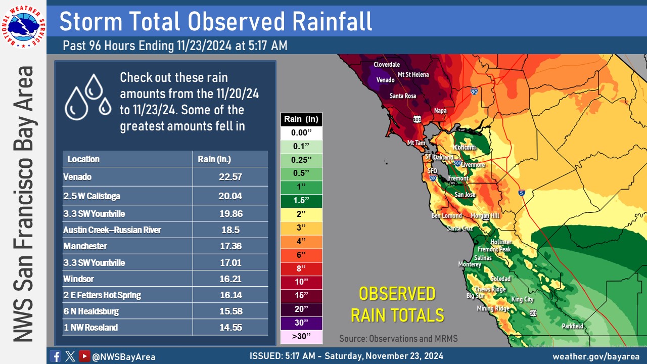
Climate
Needless to say given the prolonged rainfall we'd end up with some interesting climate stats. Rainfall amounts of over 20" in the North Bay. Daily and muli-day records were set for rainfall. Here are some other notable climate facts for Santa Rosa and San Francisco
 |
 |
 |
|
Rainfall amounts for the Bay Area and Central Coast |
WPC Rainfall total highlights the West Coast |
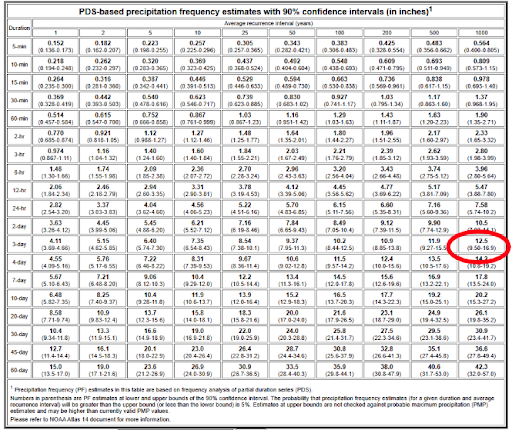
🌧️12.47" over three days qualifies as a 1000 year event at Downtown Santa Rosa. |
Numerous precipitation records were set including an impressive one day rainfall total of nearly 7 inches at Santa Rosa Airport..
RECORD EVENT REPORT NATIONAL WEATHER SERVICE SAN FRANCISCO BAY AREA 1238 AM PST THU NOV 21 2024 ...RECORD DAILY MAXIMUM RAINFALL SET AT SANTA ROSA AIRPORT... A RECORD RAINFALL OF 6.92 INCHES WAS SET AT SANTA ROSA AIRPORT YESTERDAY. THIS BREAKS THE OLD DAILY RECORD OF 1.08 INCHES SET IN 2012 AS WELL AS THE ALL TIME RECORD OF 6.09 INCHES FROM OCTOBER 24, 2021. THE PERIOD OF RECORD AT THE AIRPORT GOES BACK TO JUNE 6, 1998. ALL DATA SHOULD BE CONSIDERED PRELIMINARY. OFFICIAL AND CERTIFIED CLIMATE DATA ARE AVAILABLE FROM THE NATIONAL CENTERS FOR ENVIRONMENTAL INFORMATION: WWW.NCEI.NOAA.GOV. $$ RECORD EVENT REPORT NATIONAL WEATHER SERVICE SAN FRANCISCO BAY AREA 1234 AM PST FRI NOV 22 2024 ...RECORD DAILY MAXIMUM RAINFALL SET AT SANTA ROSA AIRPORT... A RECORD RAINFALL OF 4.93 INCHES WAS SET AT SANTA ROSA AIRPORT YESTERDAY. THIS BREAKS THE OLD RECORD OF 0.93 INCHES SET IN 2001. THE PERIOD OF RECORD AT THE AIRPORT GOES BACK TO JUNE 6, 1998. ALL DATA SHOULD BE CONSIDERED PRELIMINARY. OFFICIAL AND CERTIFIED CLIMATE DATA ARE AVAILABLE FROM THE NATIONAL CENTERS FOR ENVIRONMENTAL INFORMATION: WWW.NCEI.NOAA.GOV. $$ RECORD EVENT REPORT NATIONAL WEATHER SERVICE SAN FRANCISCO BAY AREA 134 AM PST SAT NOV 23 2024 ...RECORD DAILY MAXIMUM RAINFALL SET AT NUMEROUS LOCATIONS FOR NOV 22... LOCATION MAXIMUM PREVIOUS RECORD --------------------------------------------------------------- SANTA ROSA AP 1.96 1.22 IN 2018 SAN RAFAEL 3.57 3.51 IN 1977 SAN FRANCISCO AP 2.55 0.54 IN 1978 SAN FRANCISCO DT 2.97 1.12 IN 1865 OAKLAND MUSEUM 2.46 0.92 IN 2018 LIVERMORE 0.67 0.48 IN 1978 REDWOOD CITY 1.48 0.68 IN 1977 SAN JOSE AP 0.72 0.67 IN 1946 SALINAS AP 0.61 0.57 IN 1965 PLEASE NOTE NOT ALL SATIONS ABOVE ARE LISTED AS OFFICIAL CLIMATE STATIONS DUE TO PERIOD OF RECORD. ALL DATA SHOULD BE CONSIDERED PRELIMINARY. OFFICIAL AND CERTIFIED CLIMATE DATA ARE AVAILABLE FROM THE NATIONAL CENTERS FOR ENVIRONMENTAL INFORMATION: WWW.NCEI.NOAA.GOV. $$ |
 |
Media use of NWS Web News Stories is encouraged! Please acknowledge the NWS as the source of any news information accessed from this site. |
|