Dangerous, record-breaking heat will intensify across most of the central and eastern U.S this week. Heat indices will likely exceed 100 degrees. Severe thunderstorms are forecast from parts of the central High Plains into the Upper Midwest, and across parts of the Northeast. Critical fire weather conditions will continue across portions of the Four Corners and Great Basin. Read More >
Winter Weather February 22 to February 24
A cold core low pressure brought low elevation snow, gusty winds, and thunderstorms to California.
|
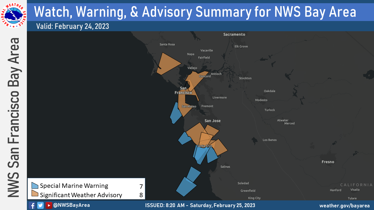
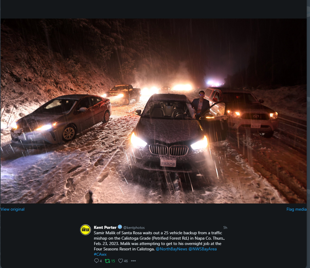
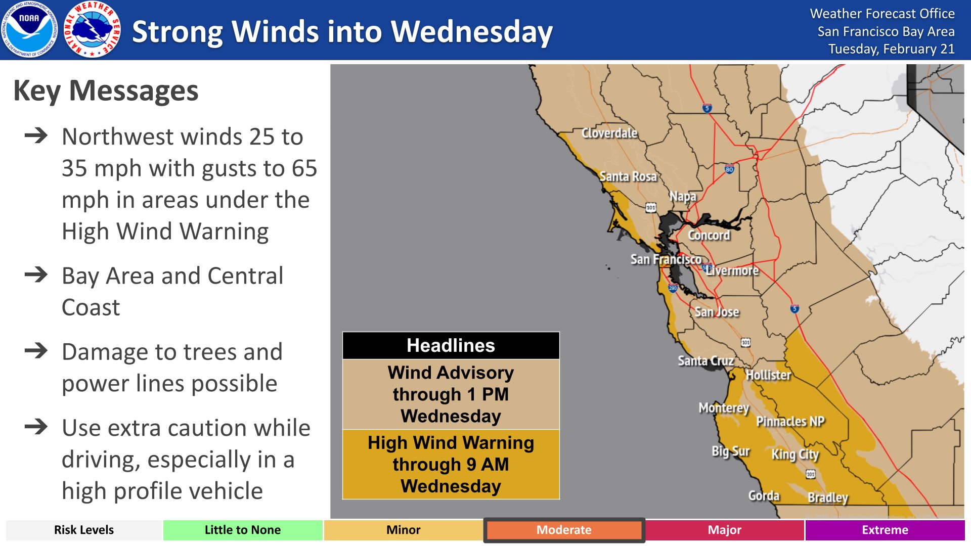
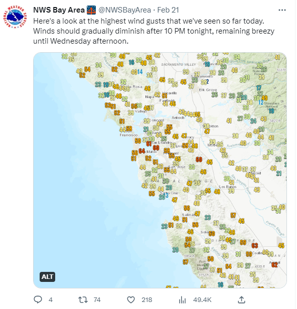
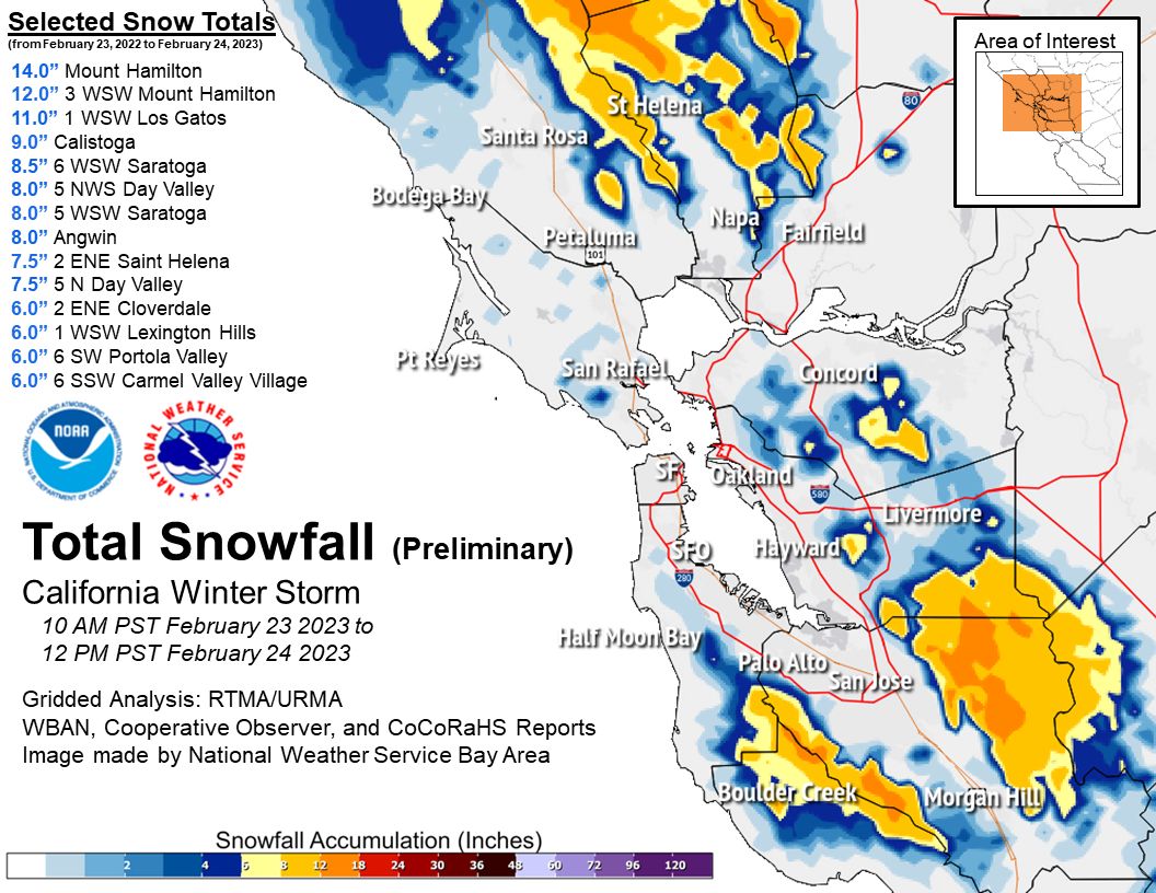
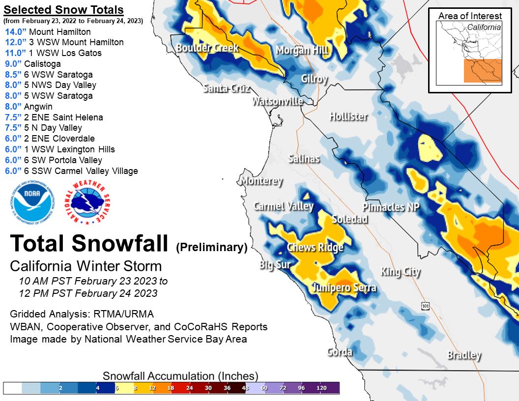
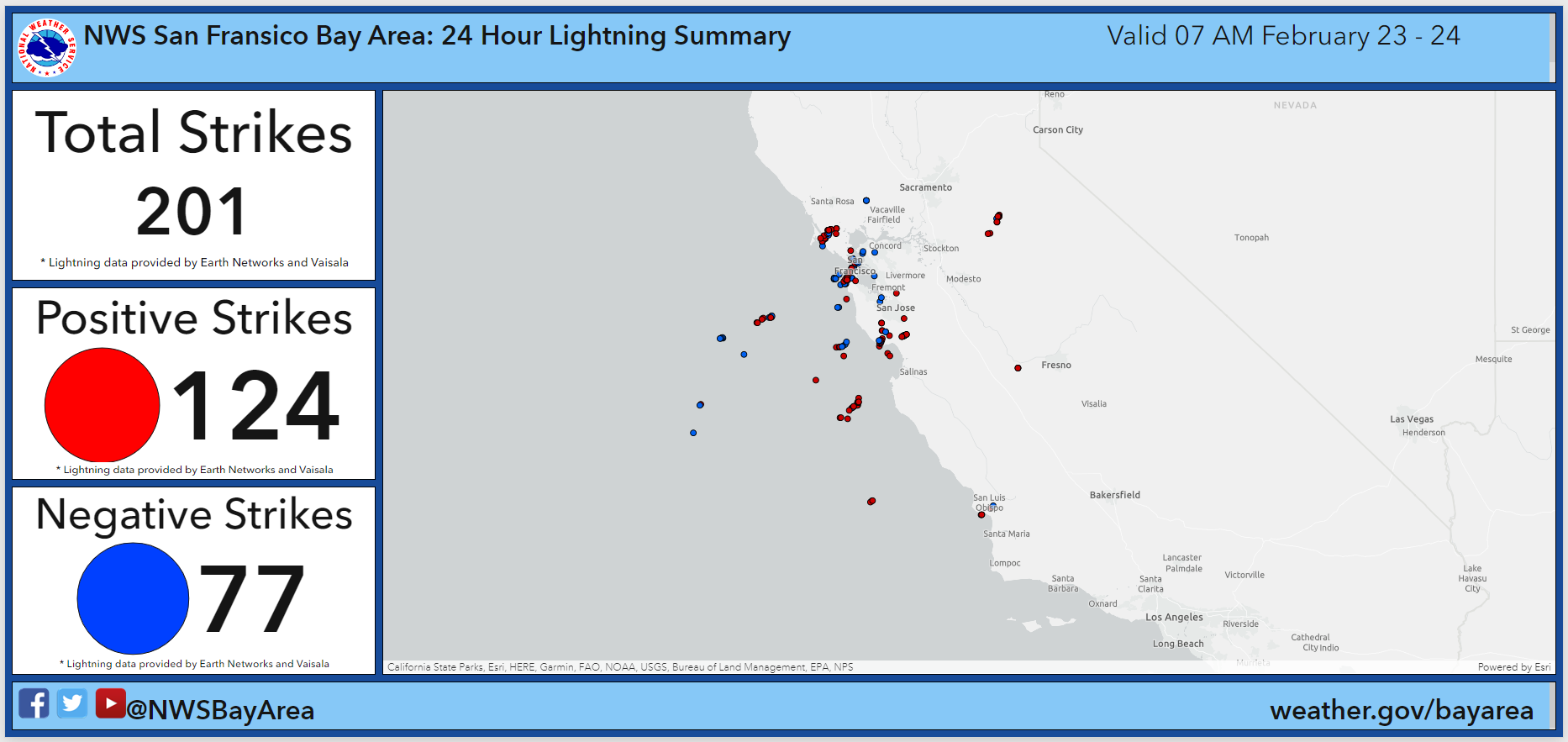
A very deep and cold upper-level low pressure system settled over the Bay Area and Central Coast the last week of February 2023. This unusual storm system brought a wide variety of impactful weather to the region: gusty winds, cold temperatures, low snow levels, and thunderstorms with hail and lightning. A cold front moved through the region on Tuesday, February 21, ushering in the first change to the airmass. Not only did the temperatures drop on Tuesday, but very gusty northwest winds developed behind the front and lasted into Wednesday. Instability also developed behind the front, which led to scattered showers Tuesday and Wednesday. Given the colder airmass some of the showers fell as snow over the higher peaks. The dynamic weather continued through the rest of the week as a very cold and deep cut off upper low moved directly the Bay Area. The upper low brought a re-enforcing shot of colder air and increased instability. The colder aided in lowering snow levels even further and in some areas below 1,000 feet, which is unusual. It’s common for the Bay Area to see snow several times a year over the higher peaks, but anytime it’s below 1,000 feet it’s more unusual and impactful. In this case, impacts were rather notable with Highway 17 near the Summit and Highway 128 near Cloverdale closing due to snow covering the roadway. A few weather spotters in the North Bay near Cloverdale reported snow down to 200-400 foot elevations. Mt Hamilton received over one foot of storm total snow and Los Gatos fell short of a foot at 11 inches of storm total snow. As for the instability, thunderstorms developed February 23-24, bringing brief heavy rain, gusty winds, lightning and enough small hail to cover the ground in places. The graphic below shows that numerous Special Weather Statements and Special Marine Warnings were issued to highlight hazards with developed storms.
Composed by: MMehle
|
|
||
|
|
Damaging Winds
 |
 |
| Wind Hazard Headlines | Peak Wind Observations |
PUBLIC INFORMATION STATEMENT NATIONAL WEATHER SERVICE SAN FRANCISCO CA 541 PM PST FRI FEB 24 2023 ...HIGHEST WIND REPORTS - PAST 24 HOURS - AS OF 530PM ON 2/24/23... LOCATION SPEED TIME/DATE LAT/LON/ELEV (FT.) ...CALIFORNIA... ...ALAMEDA COUNTY... MINES TOWER 66 MPH 1200 AM 02/24 37.61N/121.62W/2923 MT. ALISON 62 MPH 1050 PM 02/23 37.50N/121.87W/2646 ROSE PEAK 61 MPH 1128 PM 02/23 37.50N/121.74W/3060 5.5 E FREMONT (PGE) 54 MPH 1040 PM 02/23 37.55N/121.90W/1138 CALAVERAS RD RAWS 53 MPH 1118 PM 02/23 37.55N/121.84W/1229 4.0 SW PLEASANTON (PGE) 53 MPH 1050 PM 02/23 37.62N/121.92W/2134 WELLER ROAD 52 MPH 1200 AM 02/24 37.49N/121.86W/2461 MINES ROAD NORTH 49 MPH 1130 PM 02/23 37.61N/121.67W/1541 OAKLAND AIRPORT 48 MPH 0950 PM 02/23 37.72N/122.23W/8 SANTOS 47 MPH 0940 PM 02/23 37.66N/121.93W/1473 5.2 SW LIVERMORE (PGE) 44 MPH 1100 PM 02/23 37.63N/121.81W/847 LIVERMORE AIRPORT 43 MPH 1212 AM 02/24 37.70N/121.82W/399 2.9 N PIEDMONT (PGE) 43 MPH 1200 AM 02/24 37.87N/122.22W/1475 ARROYO HILLS 42 MPH 1040 PM 02/23 37.60N/121.75W/1463 NILES HILL 42 MPH 1150 PM 02/23 37.58N/121.99W/530 OAKLAND N RAWS 42 MPH 0633 PM 02/23 37.87N/122.22W/1402 8.0 SE LIVERMORE (PGE) 42 MPH 0940 PM 02/23 37.59N/121.69W/1129 2.8 SE FAIRVIEW (PGE) 42 MPH 1140 PM 02/23 37.66N/122.00W/1495 OAKLAND 41 MPH 1200 AM 02/24 37.85N/122.21W/1131 MENDENHALL SPRINGS 41 MPH 0910 PM 02/23 37.60N/121.64W/1619 OAKLAND MIDDLE HARBOR, CA 40 MPH 1000 PM 02/23 37.80N/122.33W 2.7 SE KENSINGTON (UUNET) 39 MPH 1100 PM 02/23 37.88N/122.25W/888 7.3 E LIVERMORE (PGE) 39 MPH 0800 PM 02/23 37.69N/121.63W/1604 FREMONT HILLS 39 MPH 1100 PM 02/23 37.62N/121.97W/1527 ALTAMONT RAWS 38 MPH 0812 PM 02/23 37.69N/121.61W/1436 OAKLAND 38 MPH 0830 PM 02/23 37.80N/122.22W/226 HAYWARD 38 MPH 1153 PM 02/23 37.67N/122.12W/42 14.2 NE MOUNT HAMILTON (PGE) 38 MPH 0940 PM 02/23 37.54N/121.56W/2240 EAST BAY MUD 38 MPH 0100 AM 02/24 37.78N/122.09W/969 MILL CREEK 37 MPH 1040 PM 02/23 37.52N/121.87W/1554 ALAMEDA, CA 36 MPH 1148 PM 02/23 37.77N/122.30W FREMONT 35 MPH 0626 AM 02/24 37.54N/121.97W/58 DUBLIN CANYON ROAD 35 MPH 1140 PM 02/23 37.69N/121.98W/1035 ALAMEDA MARINA 35 MPH 1133 PM 02/23 37.77N/122.29W/57 CALHOUN STREET 34 MPH 0550 PM 02/23 37.65N/122.05W/446 BLACKSTONE COURT 33 MPH 0910 PM 02/23 37.68N/122.04W/701 OAKLAND 32 MPH 0915 PM 02/23 37.84N/122.21W/931 BERKELEY 31 MPH 0805 PM 02/23 37.86N/122.28W/104 ALAMEDA 31 MPH 0919 PM 02/23 37.78N/122.30W/13 CASTRO VALLEY 31 MPH 1000 PM 02/23 37.69N/122.07W/160 6.6 SE LIVERMORE (PGE) 31 MPH 0940 PM 02/23 37.61N/121.70W/1123 6.0 NE MILPITAS (PGE) 31 MPH 1210 AM 02/24 37.51N/121.83W/899 ROYCE BEACH/TOLL PLAZA 31 MPH 0936 PM 02/23 37.83N/122.32W/15 OAKLAND IDSM 30 MPH 1120 PM 02/23 37.76N/122.22W/9 ...CONTRA COSTA COUNTY... SOUTH BLACK DIAMOND WAY 60 MPH 1230 AM 02/24 37.94N/121.89W/1881 POINT POTRERO 55 MPH 1054 PM 02/23 37.91N/122.36W LAS TRAMPAS 53 MPH 0928 PM 02/23 37.83N/122.07W/1759 FAY HILL 50 MPH 1200 AM 02/24 37.86N/122.12W/861 DIABLO-BLACKHAWK 50 MPH 1220 AM 02/24 37.84N/121.90W/1916 CONTRA COSTA 48 MPH 0110 AM 02/24 37.92N/121.98W/892 MT DIABLO 48 MPH 1220 AM 02/24 37.88N/121.91W/3849 RICHMOND 46 MPH 1019 PM 02/23 37.91N/122.35W/164 SHADOWHAWK 46 MPH 0610 PM 02/23 37.85N/122.17W/771 BLACK DIAMOND MINE 45 MPH 1240 AM 02/24 37.96N/121.89W/975 5.6 E BLACKHAWK (PGE) 43 MPH 1130 PM 02/23 37.81N/121.81W/2490 CUMMINS PEAK 43 MPH 1000 PM 02/23 38.03N/122.20W/817 ALCOSTA BOULEVARD 42 MPH 1200 AM 02/24 37.75N/121.93W/768 CABALLO RANCHERO DRIVE 42 MPH 1220 AM 02/24 37.84N/121.95W/893 BLACK DIAMOND RAWS 42 MPH 0928 PM 02/23 37.95N/121.88W/1600 MORAGA BLUFFS 41 MPH 0940 PM 02/23 37.84N/122.09W/858 SHADOWHAWK 41 MPH 1220 AM 02/24 37.86N/122.06W/800 LOS VAQUEROS RAWS 41 MPH 0645 PM 02/23 37.79N/121.73W/1100 BIG BEAR LAKE 38 MPH 0515 AM 02/24 37.96N/121.66W/22276 WILDER HILLS 38 MPH 1200 AM 02/24 37.85N/122.18W/1345 GARCIA RANCH ROAD 38 MPH 0820 PM 02/23 37.94N/122.17W/1103 LAKEWOOD MEADOW 37 MPH 0110 AM 02/24 37.93N/122.00W/395 WALNUT CREEK 37 MPH 0850 PM 02/23 37.89N/122.04W/295 3.3 SW MARTINEZ (PGE) 37 MPH 0620 PM 02/23 37.96N/122.14W/793 BRIONES-DIABLO 37 MPH 0620 PM 02/23 37.89N/122.01W/743 CONCORD AIRPORT 36 MPH 0936 PM 02/23 38.00N/122.05W/22 PITTSBURG MARINA 36 MPH 0354 AM 02/24 38.04N/121.89W AVILA ROAD 35 MPH 1240 AM 02/24 38.02N/121.99W/444 CLAYTON 34 MPH 1225 AM 02/24 37.94N/121.93W/1512 CLIFFECASTLE COURT 34 MPH 1010 PM 02/23 37.74N/121.99W/1464 7 NNW LIVERMORE 33 MPH 0925 PM 02/23 37.79N/121.79W/1552 2.8 E EL SOBRANTE (PGE) 33 MPH 0820 PM 02/23 37.97N/122.24W/242 3.0 S ANTIOCH (PGE) 33 MPH 1220 AM 02/24 37.95N/121.81W/336 BAILEY ROAD 32 MPH 1220 AM 02/24 38.01N/121.94W/290 BYRON 32 MPH 0255 AM 02/24 37.83N/121.62W/30 2.6 NW ORINDA (PGE) 32 MPH 0940 PM 02/23 37.91N/122.20W/689 HERCULES 31 MPH 1000 PM 02/23 38.03N/122.28W/13 PINOLE 31 MPH 0948 PM 02/23 37.98N/122.26W/284 5.8 SE BLACKHAWK (PGE) 31 MPH 1150 PM 02/23 37.78N/121.82W/827 BLACK DIAMOND MINES 30 MPH 1250 PM 02/24 37.98N/121.86W/710 BYRON HOT SPRINGS 30 MPH 0130 AM 02/24 37.80N/121.64W/408 PITTSBURG MARINA 30 MPH 0415 AM 02/24 38.03N/121.88W/32 ...MARIN COUNTY... RICHARDSON EAST 60 MPH 1040 PM 02/23 37.85N/122.50W/1109 ROAD TO RANCHES 59 MPH 0840 PM 02/23 38.06N/122.73W/857 LUCAS VALLEY 57 MPH 0730 PM 02/23 38.05N/122.60W/1636 PABLO POINT 57 MPH 0840 PM 02/23 38.09N/122.69W/937 GUNSIGHT FIRE ROAD 57 MPH 0830 PM 02/23 38.02N/122.63W/1148 2.0 NE WOODACRE (PGE) 49 MPH 0730 PM 02/23 38.03N/122.62W/1290 DUCK COVE ROAD 48 MPH 0640 PM 02/23 38.14N/122.92W/354 BIG ROCK 44 MPH 0633 PM 02/23 38.04N/122.57W/1500 1.3 W WOODACRE (PGE) 44 MPH 0810 PM 02/23 38.00N/122.66W/1321 PANORAMIC HIGHWAY 44 MPH 0750 PM 02/23 37.89N/122.56W/752 SNAKE ROAD 43 MPH 0840 PM 02/23 38.22N/122.92W/512 SAN RAFAEL IDSM 42 MPH 0800 PM 02/23 37.99N/122.53W/188 POINT BLUNT-ANGEL ISLAND (MT 42 MPH 1100 PM 02/23 37.85N/122.42W/69 2.1 W MILL VALLEY (PGE) 42 MPH 1010 PM 02/23 37.91N/122.58W/1033 BLITHEDALE SUMMIT 41 MPH 0800 PM 02/23 37.93N/122.56W/602 3.6 NW LAGUNITAS-FOREST KNOL 40 MPH 0840 PM 02/23 38.04N/122.74W/401 FRANCIS DRAKE HILLS SOUTH 39 MPH 0810 PM 02/23 38.09N/122.92W/190 3.4 NE BOLINAS (PGE) 39 MPH 0910 PM 02/23 37.95N/122.68W/1623 0.8 NE SAN RAFAEL (PGE) 39 MPH 0730 PM 02/23 37.99N/122.50W/1002 SAND HAUL ROAD 38 MPH 0630 PM 02/23 38.25N/122.95W/306 PT BLUNT ANGEL ISLAND 38 MPH 1007 PM 02/23 37.85N/122.42W/10 LARKSPUR LANDING 38 MPH 0753 PM 02/23 37.94N/122.51W/30 BARNABY RAWS 37 MPH 0911 PM 02/23 38.03N/122.70W/810 CERINI ROAD 37 MPH 0650 PM 02/23 38.23N/122.86W/519 TIBURON 36 MPH 1048 PM 02/23 37.89N/122.46W/534 NOVATO AIRPORT 36 MPH 0735 PM 02/23 38.15N/122.55W/1 6.0 W INVERNESS (DRI) 36 MPH 0650 PM 02/23 38.09N/122.95W/86 SAUSALITO 35 MPH 0750 PM 02/23 37.85N/122.49W/1000 SAN RAFAEL 35 MPH 0900 PM 02/23 37.98N/122.54W/518 2.7 N WOODACRE (PGE) 34 MPH 0730 PM 02/23 38.04N/122.65W/794 NICASIO VALLEY ROAD 33 MPH 0730 PM 02/23 38.10N/122.73W/241 LAGUNITAS 33 MPH 0218 AM 02/24 38.02N/122.71W/925 4.3 N LAGUNITAS-FOREST KNOLL 33 MPH 0700 PM 02/23 38.08N/122.67W/275 MARSHALL PETALUMA ROAD 33 MPH 0640 PM 02/23 38.16N/122.88W/375 3.4 W LAGUNITAS-FOREST KNOLL 32 MPH 0850 PM 02/23 38.00N/122.75W/485 1.7 SW FAIRFAX (PGE) 31 MPH 0810 PM 02/23 37.97N/122.61W/687 6.5 SW PETALUMA (PGE) 31 MPH 0840 PM 02/23 38.16N/122.69W/649 GERICKE ROAD 30 MPH 0640 PM 02/23 38.29N/122.89W/88 POINT REYES STATION 30 MPH 0616 PM 02/23 38.07N/122.81W/75 POINT REYES 30 MPH 0630 PM 02/23 38.08N/122.87W/1328 8.0 SW PETALUMA (PGE) 30 MPH 0840 PM 02/23 38.14N/122.70W/418 WOODACRE RAWS 30 MPH 0251 AM 02/24 37.99N/122.64W/1399 ...MONTEREY COUNTY... HUNTER LIGGETT 53 MPH 0400 AM 02/24 35.95N/121.23W/1828 16.9 NW LAKE NACIMIENTO (PGE 50 MPH 0350 AM 02/24 35.95N/121.00W/2790 6.0 N GONZALES (PGE) 49 MPH 0140 AM 02/24 36.59N/121.43W/944 LYNCH CANYON ROAD 45 MPH 0510 AM 02/24 36.01N/120.85W/959 6.2 NE GREENFIELD (PGE) 45 MPH 0500 AM 02/24 36.37N/121.15W/4404 PINNACLES NATIONAL PARK 45 MPH 0220 AM 02/24 36.45N/121.29W/597 12.4 SW CARMEL VALLEY VILL ( 44 MPH 0210 AM 02/24 36.38N/121.90W/403 CORRAL DE CIELO ROAD 43 MPH 1130 PM 02/23 36.53N/121.62W/3385 24.9 SW GREENFIELD (DRI) 42 MPH 0220 AM 02/24 36.07N/121.56W/2490 17.0 S CARMEL VALLEY VILL (P 42 MPH 1240 AM 02/24 36.25N/121.79W/904 MT. DEVIN ROAD 42 MPH 0300 AM 02/24 36.50N/121.91W/1644 JOLON HILLS 40 MPH 0510 AM 02/24 35.88N/120.96W/1495 SALINAS AIRPORT 39 MPH 0435 AM 02/24 36.67N/121.60W/91 7.0 E CARMEL VALLEY VILL (PG 39 MPH 1130 PM 02/23 36.53N/121.61W/3452 12.7 SW CARMEL VALLEY VILL ( 39 MPH 0100 AM 02/24 36.35N/121.88W/995 CROCKER RIDGE 39 MPH 0640 AM 02/24 36.06N/121.27W/2451 OLD STAGE ROAD 37 MPH 0420 AM 02/24 36.67N/121.53W/1306 26.2 SW GREENFIELD (DRI) 37 MPH 0550 AM 02/24 36.07N/121.60W/620 10.5 NE HEARST CASTLE (PGE) 36 MPH 0330 AM 02/24 35.81N/121.05W/1515 CRAZY HORSE 35 MPH 0120 AM 02/24 36.77N/121.58W/657 LONOAK 35 MPH 0430 AM 02/24 36.29N/120.94W/925 UPPER SADDLEBACK RIDGE 35 MPH 0200 AM 02/24 36.67N/121.52W/1331 MONTEREY AIRPORT 35 MPH 0322 AM 02/24 36.58N/121.85W/196 NACIMIENTO LAKE DRIVE 35 MPH 0450 AM 02/24 35.84N/120.84W/681 HIGHWAY 198 WEST 34 MPH 0400 AM 02/24 36.16N/120.91W/928 LONG RIDGE 34 MPH 0220 AM 02/24 36.43N/121.74W/2003 IVERSON ROAD 33 MPH 0140 AM 02/24 36.55N/121.44W/236 LOCKWOOD SAN LUCAS ROAD 33 MPH 0400 AM 02/24 36.02N/121.07W/1652 JOLON ROAD 33 MPH 0140 AM 02/24 36.11N/121.17W/1305 RESERVATION ROAD 32 MPH 0100 AM 02/24 36.63N/121.70W/83 FORT ROMIE 32 MPH 0220 AM 02/24 36.40N/121.34W/181 SHULTE ROAD 32 MPH 0300 AM 02/24 36.51N/121.83W/1137 MOUND MEADOWS 32 MPH 1215 AM 02/24 36.51N/121.94W/28 STONE CANYON 31 MPH 0740 AM 02/24 36.02N/120.52W/3375 7.8 SE SAN JUAN BAUTISTA (PG 31 MPH 1140 PM 02/23 36.75N/121.47W/2144 INDIAN VALLEY ROAD SOUTH 31 MPH 0500 AM 02/24 35.85N/120.70W/851 CENTRAL AVE 30 MPH 0200 AM 02/24 36.28N/121.22W/403 CRAZY HORSE CANYON 30 MPH 0120 AM 02/24 36.52N/121.37W/730 KING CITY IDSM 30 MPH 0200 AM 02/24 36.22N/121.13W/333 10.1 NE HEARST CASTLE (PGE) 30 MPH 0350 AM 02/24 35.83N/121.10W/1059 15.0 S COALINGA (PGE) 30 MPH 1240 PM 02/24 35.93N/120.37W/3297 ...NAPA COUNTY... ATLAS PEAK RAWS 53 MPH 0629 PM 02/23 38.47N/122.26W/1934 MOUNT HOOD 44 MPH 0720 PM 02/23 38.49N/122.54W/1938 7.8 SW BROOKS (PGE) 38 MPH 0700 PM 02/23 38.68N/122.27W/500 SAGE CANYON ROAD 37 MPH 0820 PM 02/23 38.46N/122.34W/1379 4.6 N NAPA (PGE) 35 MPH 0730 PM 02/23 38.36N/122.28W/96 6.9 N ANGWIN (PGE) 35 MPH 0620 PM 02/23 38.68N/122.45W/1011 8.1 W RUMSEY (PGE) 35 MPH 0630 PM 02/23 38.84N/122.37W/1998 AMERICAN CANYON 34 MPH 0830 PM 02/23 38.16N/122.26W/29 8.3 N YOUNTVILLE (PGE) 34 MPH 0800 PM 02/23 38.51N/122.34W/1481 SOSCOL CREEK ROAD 34 MPH 0730 PM 02/23 38.24N/122.27W/80 NAPA COUNTY AIRPORT 33 MPH 0206 AM 02/24 38.20N/122.28W/23 7.4 E YOUNTVILLE (PGE) 33 MPH 0940 PM 02/23 38.43N/122.24W/1986 4.4 NE YOUNTVILLE (PGE) 32 MPH 0220 AM 02/24 38.43N/122.30W/1515 8.0 NE NAPA (PGE) 32 MPH 0220 AM 02/24 38.38N/122.19W/617 WINE COUNTRY ROAD 32 MPH 1050 PM 02/23 38.33N/122.34W/217 HENRY ROAD 31 MPH 1050 PM 02/23 38.28N/122.36W/250 3.9 S YOUNTVILLE (PGE) 31 MPH 0810 PM 02/23 38.34N/122.39W/693 10.2 E YOUNTVILLE (PGE) 31 MPH 0920 PM 02/23 38.45N/122.19W/819 6.7 E YOUNTVILLE (PGE) 31 MPH 0840 PM 02/23 38.42N/122.25W/1453 MT. VEEDER 31 MPH 0750 PM 02/23 38.38N/122.45W/2475 LOVALL VALLEY ROAD 30 MPH 0730 PM 02/23 38.30N/122.40W/666 ...SAN BENITO COUNTY... BLACK MOUNTAIN 47 MPH 0507 AM 02/24 36.38N/120.86W/3732 LA GLORIA ROAD 39 MPH 0240 AM 02/24 36.55N/121.29W/2524 2.8 SW SAN JUAN BAUTISTA (PG 39 MPH 1020 AM 02/24 36.83N/121.58W/1276 HIGHWAY 25 37 MPH 1240 AM 02/24 36.67N/121.25W/838 PINNACLES RAWS 37 MPH 1237 AM 02/24 36.47N/121.15W/1321 19.1 NE SOLEDAD (PGE) 37 MPH 1000 PM 02/23 36.62N/121.07W/3881 SANTA ANA VALLEY ROAD 34 MPH 0310 AM 02/24 36.86N/121.35W/381 QUIEN SABE ROAD 33 MPH 0250 AM 02/24 36.81N/121.25W/1044 PAICINES 33 MPH 1210 AM 02/24 36.57N/120.96W/7217 VIBORAS ROAD 33 MPH 0450 AM 02/24 36.96N/121.34W/469 PAYNE CREEK ROAD 32 MPH 1140 PM 02/23 36.65N/121.00W/2180 12.3 NE SOLEDAD (PGE) 31 MPH 0230 AM 02/24 36.57N/121.18W/1455 LOWER NEW IDRIA 31 MPH 1110 PM 02/23 36.49N/120.80W/1932 PAICINES ROAD 30 MPH 0110 AM 02/24 36.61N/120.92W/1436 HERNANDEZ ROAD 30 MPH 0130 AM 02/24 36.51N/121.08W/1339 HOLLISTER AIRPORT 30 MPH 0235 AM 02/24 36.90N/121.42W/206 16.4 NE KING CITY (PGE) 30 MPH 0450 AM 02/24 36.41N/120.96W/2152 COTTONWOOD ROAD TOWER 30 MPH 0240 AM 02/24 36.69N/121.20W/1054 ...SAN FRANCISCO COUNTY... SAN FRANCISCO 47 MPH 1030 PM 02/23 37.77N/122.51W/31 PIER ONE 38 MPH 0218 AM 02/24 37.80N/122.39W SAN FRANCISCO 37 MPH 1125 PM 02/23 37.76N/122.44W/347 SAN FRANCISCO 32 MPH 1115 PM 02/23 37.72N/122.45W/423 SAN FRANCISCO 30 MPH 0749 PM 02/23 37.76N/122.45W/574 ...SAN MATEO COUNTY... SPRING VALLEY RAWS 63 MPH 1218 AM 02/24 37.56N/122.44W/1075 HALF MOON BAY 55 MPH 1115 PM 02/23 37.52N/122.50W/49 LAKE DRIVE 53 MPH 1050 PM 02/23 37.62N/122.45W/797 SAN FRANCISCO AIRPORT 49 MPH 1130 PM 02/23 37.62N/122.37W/7 PILLAR POINT 46 MPH 1120 PM 02/23 37.51N/122.49W/61 LA HONDA 44 MPH 1140 PM 02/23 37.30N/122.17W/2398 BFI OFFICE 43 MPH 1130 PM 02/23 37.51N/122.41W/1091 HALF MOON BAY SWITCH 41 MPH 1120 PM 02/23 37.45N/122.43W/96 SWEENEY RIDGE 41 MPH 1150 PM 02/23 37.61N/122.46W/1208 PISE MOUNTAIN 39 MPH 1140 PM 02/23 37.48N/122.36W/1393 PENINSULA 38 MPH 1100 PM 02/23 37.33N/122.21W/2389 PACIFICA 38 MPH 1036 PM 02/23 37.59N/122.48W/452 PACIFICA 37 MPH 0954 PM 02/23 37.63N/122.49W/49 SKYLINE 37 MPH 1030 PM 02/23 37.31N/122.17W/2158 LOOP ROAD 36 MPH 1020 PM 02/23 37.51N/122.34W/497 ANO NUEVO 36 MPH 1200 AM 02/24 37.14N/122.32W/155 5.5 W WOODSIDE (PGE) 36 MPH 1010 PM 02/23 37.39N/122.35W/1295 PACIFICA 34 MPH 1035 PM 02/23 37.63N/122.49W/260 CANDLESTICK PT 34 MPH 0959 PM 02/23 37.70N/122.40W/45 MIRAMONTES POINT ROAD 32 MPH 1100 PM 02/23 37.43N/122.42W/143 3.9 SW PORTOLA VALLEY (PGE) 32 MPH 1130 PM 02/23 37.34N/122.28W/972 COLMA - SAND HILL 30 MPH 1010 PM 02/23 37.68N/122.44W/541 ...SANTA CLARA COUNTY... SODA SPRINGS ROAD 66 MPH 1220 AM 02/24 37.17N/121.94W/2727 LOS GATOS RAWS 61 MPH 1032 PM 02/23 37.20N/121.95W/1841 SIERRA AZUL 61 MPH 1210 AM 02/24 37.18N/121.92W/2833 MT. UMUNHUM 57 MPH 1230 AM 02/24 37.16N/121.91W/3318 LOMA PRIETA 55 MPH 1010 PM 02/23 37.14N/121.89W/3225 STUART RIDGE 52 MPH 1000 PM 02/23 37.23N/122.05W/2003 POO107 LOMA CHIQUITA 50 MPH 0720 PM 02/23 37.10N/121.83W/2607 PRIEST ROCK 47 MPH 0940 PM 02/23 37.19N/121.96W/1740 BLACK MOUNTAIN 46 MPH 1050 PM 02/23 37.33N/122.18W/2229 KNPT TOWERS 42 MPH 1100 PM 02/23 37.11N/121.84W/3722 MONTE BELLO ROAD WEST 41 MPH 1110 PM 02/23 37.30N/122.12W/2321 SAN JOSE 40 MPH 1237 AM 02/24 37.38N/121.81W/577 MT BIELAWSKI 40 MPH 0750 PM 02/23 37.22N/122.03W/2522 PIERCY RANCH ROAD 40 MPH 1040 PM 02/23 37.24N/121.76W/391 SAN JOSE AIRPORT 39 MPH 1034 PM 02/23 37.37N/121.92W/48 KAHLER COURT 39 MPH 0130 AM 02/24 37.43N/121.81W/1783 SWEIGERT ROAD 39 MPH 1020 PM 02/23 37.42N/121.84W/873 BOUNDARY 39 MPH 0100 AM 02/24 37.21N/121.77W/929 EL SERENO 38 MPH 0700 PM 02/23 37.21N/122.02W/2299 POVERTY 37 MPH 1219 AM 02/24 37.44N/121.77W/2065 3.1 NE EAST FOOTHILLS (PGE) 37 MPH 0130 AM 02/24 37.42N/121.78W/2073 LEXINGTON RESERVOIR 37 MPH 0950 PM 02/23 37.20N/121.99W/666 GUADALUPE MINES 36 MPH 1040 PM 02/23 37.21N/121.90W/650 10.8 N HOLLISTER (PGE) 36 MPH 1200 AM 02/24 37.01N/121.37W/521 2.7 NW SAN JOSE (SJSUNET) 36 MPH 1135 PM 02/23 37.33N/121.88W/159 LOMA CHIQUITA 34 MPH 1010 PM 02/23 37.11N/121.82W/2584 HARRY ROAD 34 MPH 1140 PM 02/23 37.22N/121.80W/987 FOWLER ROAD 34 MPH 1030 PM 02/23 37.31N/121.75W/514 MONTE VISTA 34 MPH 1050 PM 02/23 37.28N/122.11W/1566 REID HILLVIEW SAN JOSE 33 MPH 0855 PM 02/23 37.32N/121.82W/141 CORDOZA RIDGE 32 MPH 0302 AM 02/24 37.17N/121.53W/2331 SARATOGA 32 MPH 1005 PM 02/23 37.24N/122.04W/2020 FRAZIER LAKE ROAD 32 MPH 0330 AM 02/24 36.98N/121.42W/402 UVAS HILL 31 MPH 0630 PM 02/23 37.07N/121.68W/1092 SAN MARTIN AIRPORT 31 MPH 0155 AM 02/24 37.08N/121.60W/281 3.2 E EAST FOOTHILLS (PGE) 31 MPH 1150 PM 02/23 37.36N/121.76W/1515 KLEIN ROAD 31 MPH 1230 AM 02/24 37.34N/121.78W/353 BAYLANDS NATURE CENTER PALO 31 MPH 0747 PM 02/23 37.46N/122.11W/35 QUIMBY ROAD 30 MPH 0120 AM 02/24 37.35N/121.74W/2123 MILPITAS IDSM 30 MPH 1050 PM 02/23 37.43N/121.92W/23 8.5 N HOLLISTER (CALTRANS) 30 MPH 1210 AM 02/24 36.98N/121.38W/299 CUPERTINO 30 MPH 0800 PM 02/23 37.30N/122.10W/1350 MOFFETT FIELD 30 MPH 0835 PM 02/23 37.40N/122.05W/48 4.2 NE CORRALITOS (PGE) 30 MPH 1130 PM 02/23 37.05N/121.76W/2458 ...SANTA CRUZ COUNTY... 2.4 SW SANTA CRUZ (DRI) 44 MPH 0200 AM 02/24 36.95N/122.07W/8 COAST DAIRIES 42 MPH 0109 AM 02/24 37.03N/122.19W/723 SANTA CRUZ 41 MPH 0215 AM 02/24 36.97N/121.96W/49 DIMEO LANE 41 MPH 1010 PM 02/23 36.97N/122.10W/241 SWANTON ROAD 40 MPH 1240 AM 02/24 37.04N/122.21W/337 LAS TRANCAS 39 MPH 1007 PM 02/23 37.09N/122.27W/35 SANTA CRUZ 38 MPH 0217 AM 02/24 36.97N/122.03W/9 BOULDER CREEK 38 MPH 1005 PM 02/23 37.23N/122.15W/2001 LAST CHANCE ROAD 37 MPH 1210 AM 02/24 37.09N/122.26W/600 SANTA CRUZ 37 MPH 1100 PM 02/23 36.95N/122.05W/49 3.1 NE DAY VALLEY (PGE) 35 MPH 1130 PM 02/23 37.07N/121.82W/2513 APTOS 34 MPH 0645 PM 02/23 36.96N/121.89W/19 LOS GATOS 33 MPH 0735 PM 02/23 37.20N/122.07W/2693 LOS GATOS 32 MPH 0119 AM 02/24 37.13N/121.95W/1640 APTOS 32 MPH 0846 PM 02/23 36.95N/121.87W/738 MOSS LANDING HILLS 31 MPH 0140 AM 02/24 36.94N/121.65W/1543 SANTA CRUZ 30 MPH 0157 AM 02/24 36.97N/121.97W/65 WATSONVILLE AIRPORT 30 MPH 0154 AM 02/24 36.93N/121.78W/129 3.2 W LEXINGTON HILLS (PGE) 30 MPH 1140 PM 02/23 37.17N/122.03W/2243 ...SONOMA COUNTY... COBB RIDGE WEST 56 MPH 0620 PM 02/23 38.82N/122.81W/3225 1.7 S TEMELEC (PGE) 49 MPH 0850 PM 02/23 38.23N/122.50W/825 4.5 SW FOREST LAKE (PGE) 45 MPH 0630 PM 02/23 38.76N/122.76W/3308 7.5 W MONTE RIO (PGE) 43 MPH 0640 PM 02/23 38.51N/123.14W/1766 COLEMAN VALLEY ROAD SOUTH 43 MPH 0550 PM 02/23 38.37N/123.05W/869 CLOUD LANE 41 MPH 0740 PM 02/23 38.20N/122.60W/194 BODEGA 41 MPH 0630 PM 02/23 38.35N/122.96W/144 4.8 SW ANDERSON SPRINGS (PGE 41 MPH 0630 PM 02/23 38.73N/122.76W/2479 COLEMAN VALLEY ROAD WEST 40 MPH 0640 PM 02/23 38.39N/123.04W/955 SONOMA MOUNTAIN 39 MPH 0800 PM 02/23 38.34N/122.58W/2390 MT ST HELENA 38 MPH 0810 PM 02/23 38.67N/122.63W/4339 ENGLISH HILL 38 MPH 0650 PM 02/23 38.35N/122.87W/907 KORTUM TRAIL 37 MPH 0530 PM 02/23 38.42N/123.10W/178 OSPREY DRIVE 37 MPH 0630 PM 02/23 38.30N/123.00W/253 SALMON CREEK OVERLOOK 37 MPH 0640 PM 02/23 38.35N/123.05W/303 SANTA FE GEOTHERMAL 37 MPH 0620 PM 02/23 38.79N/122.75W/3880 JENNER ROAD 37 MPH 0630 PM 02/23 38.47N/123.13W/997 HAWKEYE RAWS 36 MPH 0756 PM 02/23 38.74N/122.84W/2023 13.5 NW MONTE RIO (PGE) 35 MPH 0630 PM 02/23 38.60N/123.19W/1470 8.2 N HEALDSBURG (PGE) 34 MPH 0610 PM 02/23 38.74N/122.83W/2083 11.8 NW MONTE RIO (PGE) 34 MPH 0550 PM 02/23 38.55N/123.20W/1480 SANTA ROSA RAWS 34 MPH 0729 PM 02/23 38.48N/122.71W/599 5.1 NE LARKFIELD-WIKIUP (PGE 33 MPH 0720 PM 02/23 38.56N/122.68W/1060 16.5 SE GUALALA (PGE) 33 MPH 0530 PM 02/23 38.62N/123.29W/1064 CAZADERO 32 MPH 0615 PM 02/23 38.53N/123.13W/1968 3.9 N FORESTVILLE (PGE) 32 MPH 0630 PM 02/23 38.54N/122.90W/556 SALMON CREEK RANCH 32 MPH 0640 PM 02/23 38.35N/123.01W/513 UPPER CAVEDALE ROAD 32 MPH 0820 PM 02/23 38.37N/122.46W/2128 BURNSIDE ROAD 31 MPH 0650 PM 02/23 38.38N/122.87W/544 SANTA ROSA 31 MPH 0702 PM 02/23 38.50N/122.82W/107 1.8 W BODEGA BAY (DRI) 31 MPH 0550 PM 02/23 38.31N/123.06W/100 MEYERS GRADE 30 MPH 0530 PM 02/23 38.51N/123.20W/1611 SONOMA IDSM 30 MPH 0910 PM 02/23 38.27N/122.46W/46 4.3 SW SAINT HELENA (PGE) 30 MPH 0720 PM 02/23 38.45N/122.51W/2529 ...MARITIME STATIONS... 38 W HEARST CASTLE 60 MPH 0300 AM 02/24 35.70N/121.86W RICHMOND - BRICKYARD COVE 51 MPH 0854 PM 02/23 37.90N/122.39W/25 BODEGA BAY 46 MPH 0540 PM 02/23 38.32N/123.04W/40 CORTE MADERA CHNL. 45 MPH 1044 PM 02/23 37.93N/122.47W/20 RODEO MARINA 45 MPH 1133 PM 02/23 38.05N/122.33W/25 POINT ISABEL SHORELINE 44 MPH 1010 PM 02/23 37.90N/122.32W/30 24 WSW MONTARA 43 MPH 0850 PM 02/23 37.36N/122.88W 13 SW BOLINAS 43 MPH 0850 PM 02/23 37.75N/122.84W GOLDEN GATE BRIDGE 42 MPH 1115 PM 02/23 37.82N/122.48W/270 , CA 42 MPH 0801 PM 02/23 37.87N/122.33W/20 , 42 MPH 0130 AM 02/24 37.96N/122.48W/21 16 WSW BODEGA BAY 40 MPH 0620 PM 02/23 38.23N/123.32W 23 WSW SANTA CRUZ 40 MPH 1150 PM 02/23 36.78N/122.40W DAVIS POINT 40 MPH 0818 PM 02/23 38.06N/122.26W UNION PACIFIC RAIL RD BRIDGE 40 MPH 0130 AM 02/24 38.04N/122.12W PILLAR POINT HARBOR 40 MPH 1021 PM 02/23 37.50N/122.49W/24 SAN LEANDRO MARINA 37 MPH 0342 AM 02/24 37.70N/122.19W/25 1 SE BRISBANE 37 MPH 1136 PM 02/23 37.67N/122.37W/23 OAKLAND OUTER HARBOR 36 MPH 1000 PM 02/23 37.81N/122.33W NEAR POINT RICHMOND 36 MPH 1036 PM 02/23 37.93N/122.40W MARINERS POINT SAN MATEO 34 MPH 0355 AM 02/24 37.59N/122.27W/25 4 E COLLINSVILLE 34 MPH 0525 AM 02/24 38.08N/121.77W/31 TREASURE ISLAND 34 MPH 0831 PM 02/23 37.83N/122.37W/32 PORT CHICAGO, CA 33 MPH 1224 AM 02/24 38.06N/122.04W OAKLAND INNER HARBOR 32 MPH 1148 PM 02/23 37.80N/122.29W CARQUINEZ STRAIT 32 MPH 1118 PM 02/23 38.03N/122.13W SHERMAN M12 30 MPH 0531 AM 02/24 38.06N/121.79W/23 OBSERVATIONS ARE COLLECTED FROM A VARIETY OF SOURCES WITH VARYING EQUIPMENT AND EXPOSURES. WE THANK ALL VOLUNTEER WEATHER OBSERVERS FOR THEIR DEDICATION. NOT ALL DATA LISTED ARE CONSIDERED OFFICIAL. $$ |
PRELIMINARY LOCAL STORM REPORT...SUMMARY
NATIONAL WEATHER SERVICE SAN FRANCISCO CA
929 AM PST SAT FEB 25 2023

..TIME...   ...EVENT...      ...CITY LOCATION...     ...LAT.LON...
..DATE...   ....MAG....      ..COUNTY LOCATION..ST.. ...SOURCE....
            ..REMARKS..

0757 AM     NON-TSTM WND DMG 4 NE GLEN ELLEN         38.39N 122.49W
02/24/2023                   SONOMA             CA   PUBLIC

            SOCIAL MEDIA REPORT OF TREES BEGINNING TO
            FALL AROUND 1AM, AND CONTINUING TO DO SO
            THROUGH THIS MORNING. WIND PLAYING A FACTOR,
            WITH SNOW WEIGHT CONTRIBUTING.

0200 AM     NON-TSTM WND DMG SANTA CRUZ              36.97N 122.03W
02/24/2023                   SANTA CRUZ         CA   PUBLIC

            SOCIAL MEDIA REPORT SHOWING SEVERAL TREES
            AND LARGE BRANCHES THAT WERE BROUGHT DOWN
            AROUND THE SAME TIME A SPECIAL WEATHER
            STATEMENT WAS ISSUED FOR THE SANTA CRUZ AND
            BEN LOMOND AREA.

0716 AM     NON-TSTM WND DMG 3 SSW LEXINGTON HILLS   37.13N 122.00W
02/24/2023                   SANTA CRUZ         CA   LAW ENFORCEMENT

            POWER LINES DOWN IN ROADWAY.

0755 AM     NON-TSTM WND DMG BOULDER CREEK           37.13N 122.13W
02/24/2023                   SANTA CRUZ         CA   LAW ENFORCEMENT

            TREE DOWN, LEANING ON WIRES. WIND AND THE
            SNOW WEIGHT MAY HAVE PLAYED A FACTOR.

0847 AM     NON-TSTM WND DMG 5 NNW BOULDER CREEK     37.20N 122.16W
02/24/2023                   SANTA CRUZ         CA   LAW ENFORCEMENT

            LOTS OF FALLEN TREES AND DOWNED POWERLINES.
            COULD BE A COMBINATION OF WIND DAMAGE AND
            WEIGHT OF SNOW ON TREE BRANCHES.

0948 AM     NON-TSTM WND DMG 1 SSE BOULDER CREEK     37.13N 122.12W
02/24/2023                   SANTA CRUZ         CA   LAW ENFORCEMENT

            ROAD CLOSURE DUE TO MULTIPLE TREES DOWN IN
            ROADWAY.

1016 AM     NON-TSTM WND DMG 3 NNW BOULDER CREEK     37.18N 122.14W
02/24/2023                   SANTA CRUZ         CA   LAW ENFORCEMENT

            TREES DOWN ON POWER LINES. MOST LIKELY WIND
            DAMAGE, THOUGH SNOW WEIGHT MAY BE PLAYING A
            FACTOR.

1038 AM     NON-TSTM WND DMG 2 SSE SANTA CRUZ        36.95N 122.03W
02/24/2023                   SANTA CRUZ         CA   PUBLIC

            REPORT VIA SOCIAL MEDIA OF TREE DAMAGE AT
            LIGHTHOUSE FIELD STATE BEACH NEAR LIGHTHOUSE
            POINT. REPORTED THAT LARGE, TRUNK-SIZE LIMBS
            FELL FROM TREES.

1010 AM     NON-TSTM WND DMG 2 SSW LEXINGTON HILLS   37.14N 121.98W
02/24/2023                   SANTA CLARA        CA   LAW ENFORCEMENT

            POWER LINES DOWN ACROSS ROADWAY.

0737 AM     NON-TSTM WND DMG 10 SE CARMEL VALLEY VIL 36.40N 121.58W
02/24/2023                   MONTEREY           CA   LAW ENFORCEMENT

            TREES DOWN IN ROADWAY. WINDS THE MOST LIKELY
            FACTOR, WEIGHT OF SNOW MAY HAVE ALSO
            CONTRIBUTED.

0737 AM     NON-TSTM WND DMG 10 SE CARMEL VALLEY VIL 36.40N 121.58W
02/24/2023                   MONTEREY           CA   LAW ENFORCEMENT

            TREES DOWN IN ROADWAY. WINDS THE MOST LIKELY
            FACTOR, WEIGHT OF SNOW MAY HAVE ALSO
            CONTRIBUTED.


&&

$$
|
Low Elevation Snow
 |
 |
 |
|
Snowfall totals for Bay Area and Central Coast. |
Snowfall totals for Bay Area. |
Snowfall totals for Central Coast. |
 |
 |
 |
|
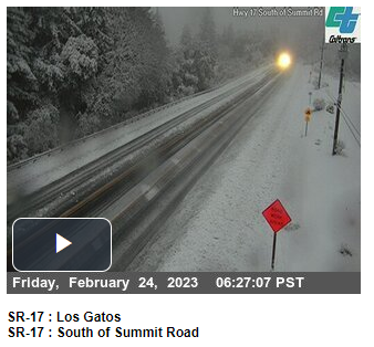
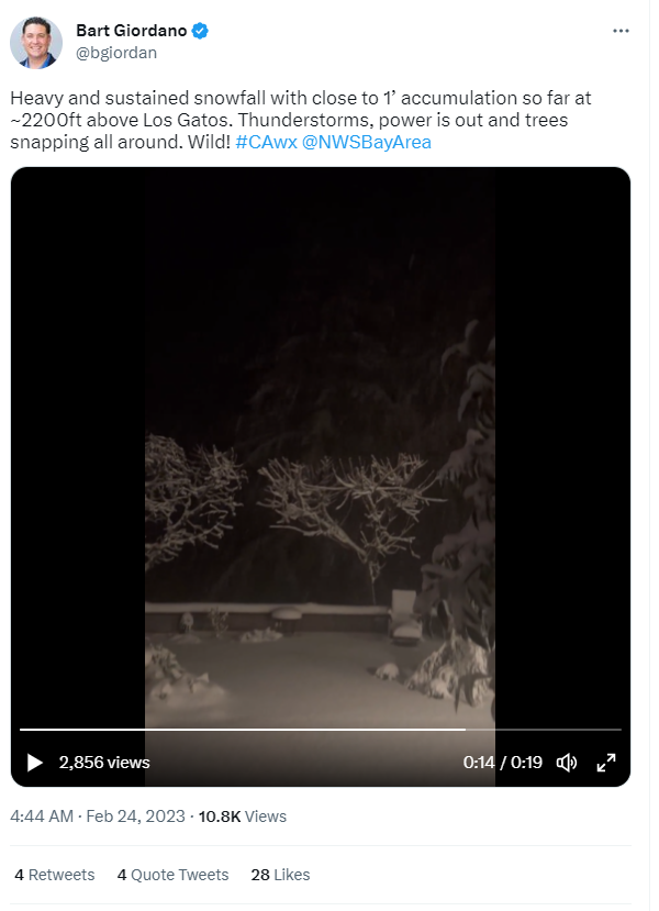
Snow impacting Hwy 17 near Los Gatos 📹 Cal Trans. |
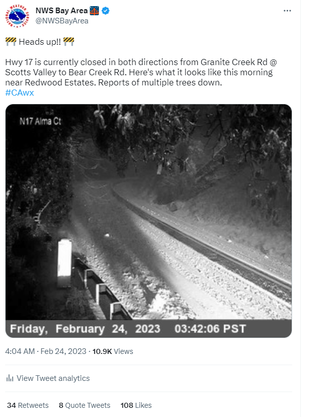
Tweet relaying information that Hwy 17 was closed due to snow. |
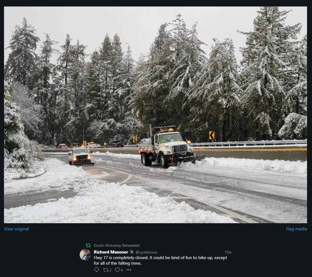
Picture by @cyclelicious |
 |
 |
|
|
|
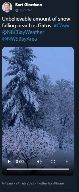
Snow pictures and video from Los Gatos Pictures and video by @bgiordan |
|
 |
 |
|
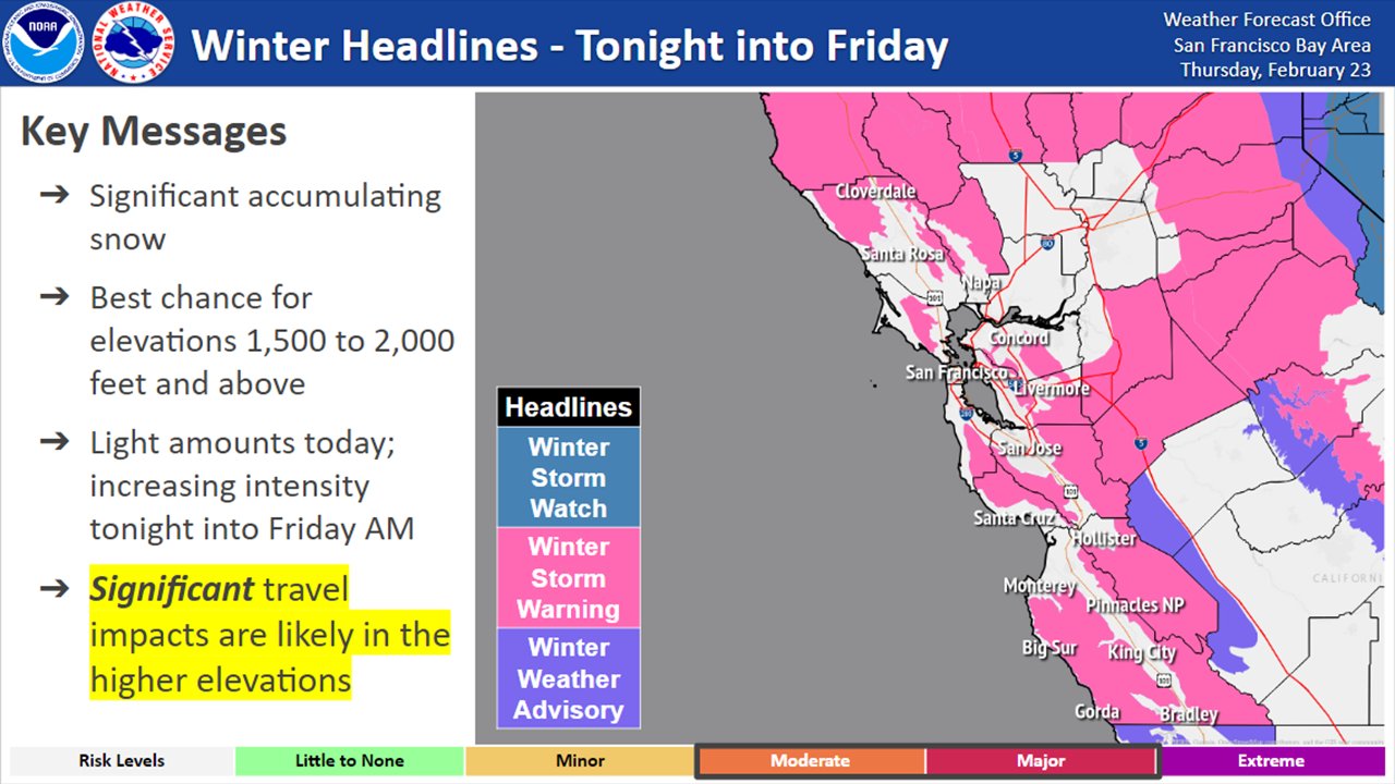
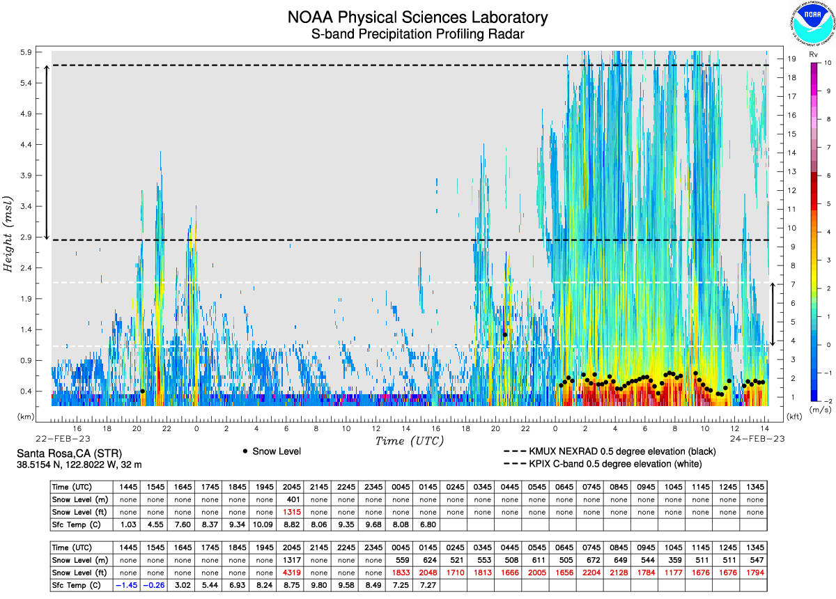
| A rare Winter Storm Warning issued for elevations above 1,500 feet. | Automated Snow Profiler showing the rapid drop to less than 2,000 feet. |
PUBLIC INFORMATION STATEMENT NATIONAL WEATHER SERVICE SAN FRANCISCO CA 206 PM PST FRI FEB 24 2023 ...SNOWFALL REPORTS - THROUGH 2PM PST ON 2/24/23... LOCATION AMOUNT TIME/DATE LAT/LON/ELEV (FT.) MOUNT HAMILTON 14.0 IN 0924 AM 02/24 37.34N/121.64W/4202 3 WSW MOUNT HAMILTON 12.0 IN 0949 AM 02/24 37.33N/121.69W 1 WSW LOS GATOS 11.0 IN 0701 AM 02/24 37.22N/121.98W CALISTOGA 9.0 IN 1251 PM 02/24 38.58N/122.58W 6 WSW SARATOGA 8.5 IN 0833 AM 02/24 37.24N/122.12W 5 NNW DAY VALLEY 8.0 IN 0701 AM 02/24 37.10N/121.89W 5 SSW SARATOGA 8.0 IN 0940 AM 02/24 37.20N/122.07W ANGWIN 8.0 IN 1028 AM 02/24 38.57N/122.44W 2 ENE SAINT HELENA 8.0 IN 1040 AM 02/24 38.52N/122.44W 5 N DAY VALLEY 7.5 IN 0726 AM 02/24 37.10N/121.87W LEXINGTON HILLS 6.5 IN 0817 AM 02/24 37.17N/121.98W 2 ENE CLOVERDALE 6.0 IN 0835 AM 02/24 38.81N/122.97W 1 WSW LEXINGTON HILLS 6.0 IN 0738 AM 02/24 37.16N/121.99W/1612 6 SW PORTOLA VALLEY 6.0 IN 1123 AM 02/24 37.32N/122.30W 6 SSW CARMEL VALLEY VILL 6.0 IN 0900 AM 02/24 36.40N/121.75W 3 WSW WOODSIDE 5.0 IN 1252 PM 02/24 37.41N/122.31W CLOVERDALE 4.0 IN 0734 AM 02/24 38.81N/123.02W 4 NNE ELDRIDGE 4.0 IN 0828 AM 02/24 38.39N/122.47W 2 SSW LEXINGTON HILLS 4.0 IN 1015 AM 02/24 37.14N/121.98W 4 W FELTON 3.5 IN 1003 AM 02/24 37.04N/122.15W CLOVERDALE 3.0 IN 0630 AM 02/24 38.81N/123.02W 1 S CLOVERDALE 3.0 IN 0935 AM 02/24 38.78N/123.02W 2 W PORTOLA VALLEY 3.0 IN 0953 AM 02/24 37.38N/122.26W 2 WNW WOODSIDE 3.0 IN 1258 PM 02/24 37.44N/122.29W ANGWIN 3.0 IN 0930 PM 02/23 38.58N/122.45W 3 W ORINDA 3.0 IN 0832 AM 02/24 37.88N/122.23W 1 S BOULDER CREEK 2.0 IN 0753 AM 02/24 37.13N/122.13W 1 SSE ANGWIN 2.0 IN 0953 PM 02/23 38.56N/122.44W 3 W ORINDA 2.0 IN 0753 AM 02/24 37.88N/122.23W 3 WSW KENTFIELD 1.5 IN 0830 AM 02/24 37.93N/122.59W 6 S PORTOLA VALLEY 1.0 IN 0705 AM 02/24 37.28N/122.21W/1259 3 WNW PORTOLA VALLEY 1.0 IN 0852 AM 02/24 37.39N/122.26W 20 WSW CLOVERDALE 0.8 IN 0722 AM 02/24 38.72N/123.37W 1 WSW FELTON 0.6 IN 0820 AM 02/24 37.04N/122.08W 3 E CLAYTON 0.5 IN 0742 AM 02/24 37.94N/121.87W OBSERVATIONS ARE COLLECTED FROM A VARIETY OF SOURCES WITH VARYING EQUIPMENT AND EXPOSURES. WE THANK ALL VOLUNTEER WEATHER OBSERVERS FOR THEIR DEDICATION. NOT ALL DATA LISTED ARE CONSIDERED OFFICIAL. $$ |
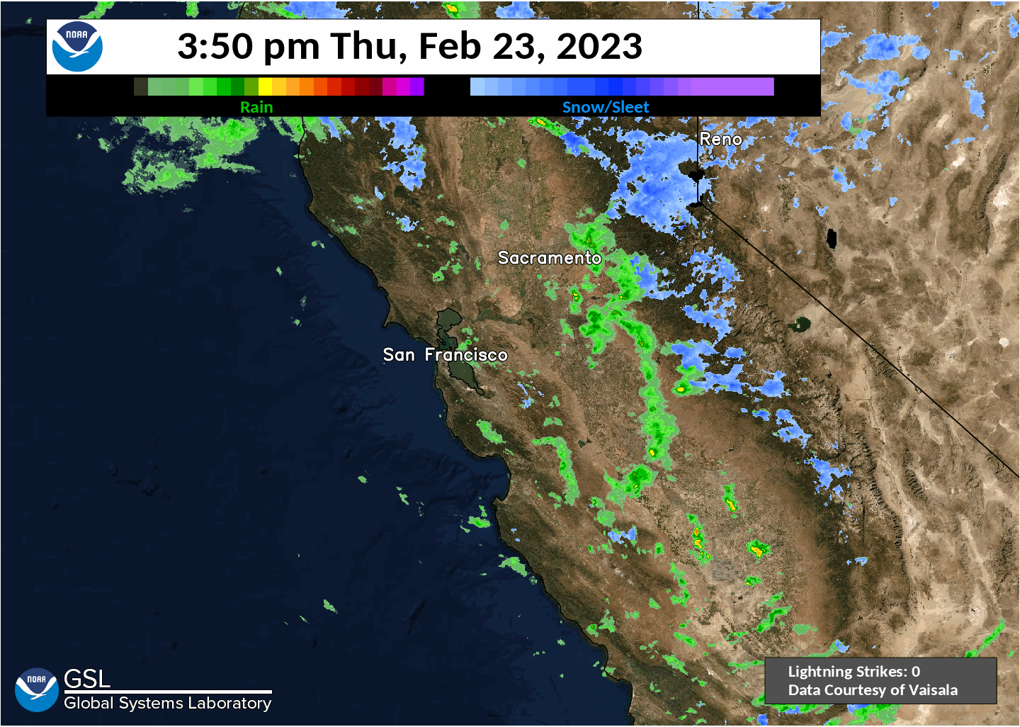
Thunderstorms
 |
 |
 |
|
Lightning plot map. |
Scattered showers and thunderstorms rolling through the Bay Area. |
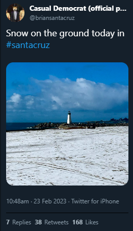
Lots of small hail covering the ground near the Santa Cruz Lighthouse Picture by @briansantacruz |
 |
Media use of NWS Web News Stories is encouraged! Please acknowledge the NWS as the source of any news information accessed from this site. |
|