
Extreme heat continues today from the central Plains to the lower Mississippi River Valley, over southeast Montana, and from southern California into the Southwest Deserts. Extreme Heat Warnings remain in effect. Severe thunderstorms capable of strong to severe wind gusts and large hail are possible across the Great Lakes into the Ohio Valley today into tonight. Read More >
| Drought Information Statements from Weather Forecast Offices | |
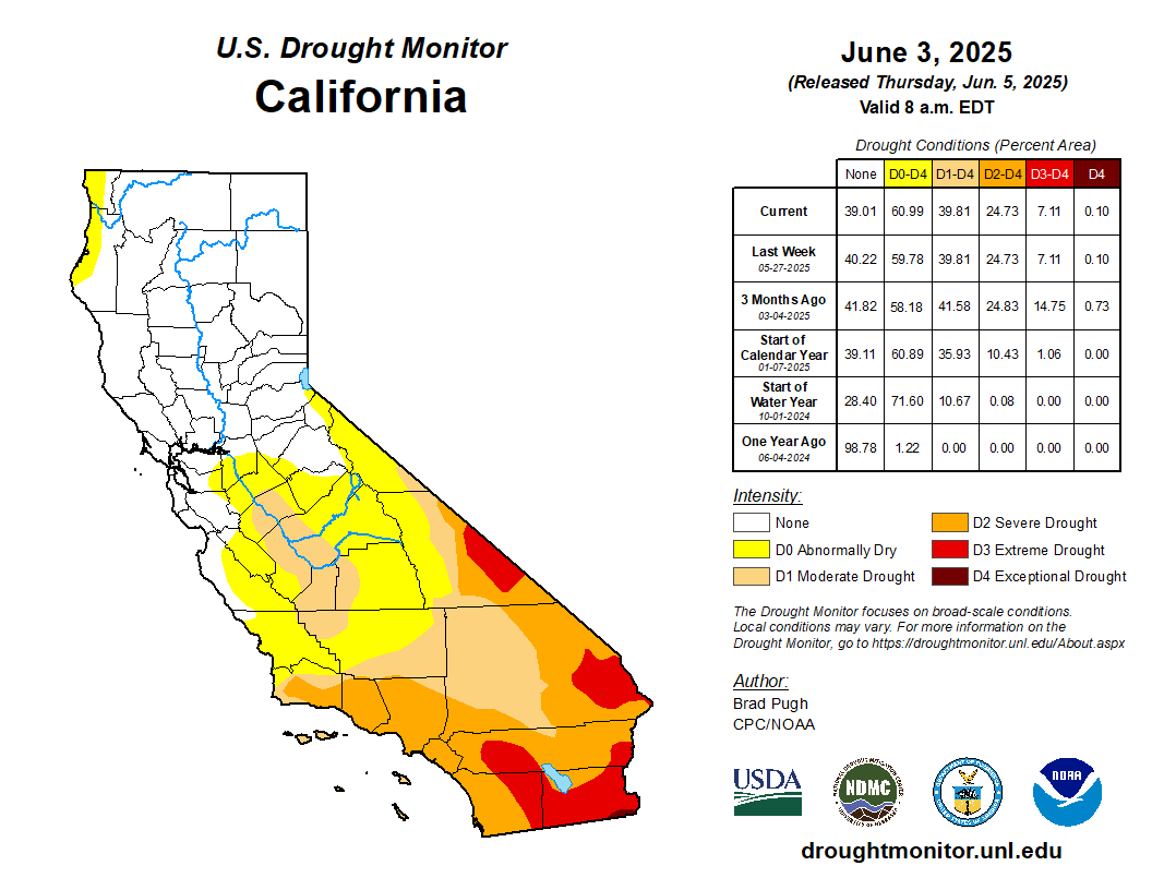
| Drought Monitor and Outlook | |
 |
 |
|
|
|
 |
 |
| Observed Precipitation Maps |
| Observed Conditions and Impacts |
| Forecasts and Outlooks | |
|
San Francisco/Monterey Bay Area forecast discussion
|
* Coastal North Bay including Point Reyes National Seashore below 1000 feet * North Bay Interior Valleys below 1000 feet * San Francisco County * North Bay Mountains 1000 feet and above * San Francisco Bay Shoreline below 1000 feet * San Francisco Peninsula Coast below 1000 feet * East Bay Interior Valleys below 1000 feet * East Bay Hills and the Diablo Range 1000 feet and above * Santa Cruz Mountains 1000 feet and above * Santa Clara Valley below 1000 feet * Northern Monterey Bay * Southern Monterey Bay and Big Sur Coast * Northern Salinas Valley/Hollister and Carmel Valley * Southern Salinas Valley, Arroyo Seco, and Lake San Antonio below 1000 feet * Santa Lucia Mountains and Los Padres National Forest 1000 feet and above * Mountains of San Benito County and Interior Monterey County, including Pinnacles National Park 1000 feet and above |
| * Days 1-3 Quantitative Precipitation Forecast (QPF) for SF/Monterey Bay Area * Weather Prediction Center 7-day QPF * CPC 8-14 day outlook * Soil Moisture Outlook for the Coterminous U.S. |
|
|
|
|
 |
 |
| Other Useful Links | |
| * | NOAA NWS CA-NV River Forecast Center Drought Information |
| * | NWS Climate Prediction Center (CPC) Drought Information |
| * | California State Water Resources Control Board (SWRCB) Drought Actions |
| * | Southern CA Seasonal Fire Outlook (pdf) |
| * | U.S. Drought Risk Atlas and Map Viewer |


