Widespread life-threatening flash and urban flooding continues in south-central Texas, with considerable flooding impacts possible across central Texas. Wildfire smoke is impacting air quality across much of the Great Lakes region into southern New England and the Mid-Atlantic. Monsoonal thunderstorms may produce isolated to scattered flash flooding across the Southwest into the Great Basin. Read More >
| Severe Weather Event January 20th | ||
|
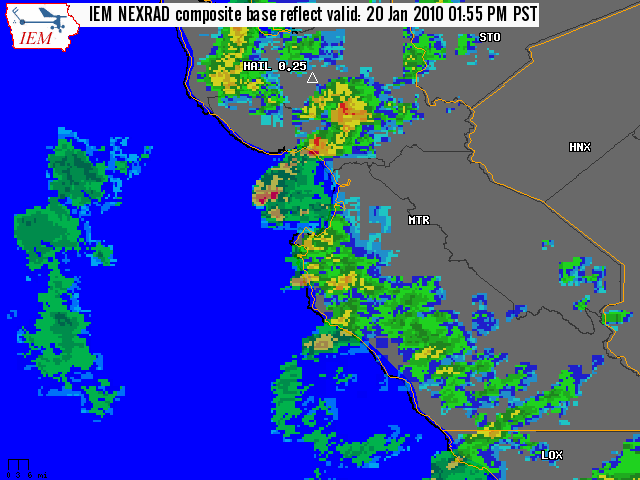
A powerful storm system impacted much of the Central California Coast on January 20th bringing a round of severe weather to the Bay Area. A very strong jet stream aloft, cold air aloft and a cold front at the surface all helped to destabilize the atmosphere, thus setting the stage for thunderstorms. Generally speaking, a majority of the storms that developed were low-topped fast moving cells that were shortlived(order of 5-15 minutes). However, a few storms strengthened to potentially hazardous levels. Through the course of the day several special marine warnings, severe thunderstorm warnings and even one tornado warning were issued. Thankfully, no reports of major damage were called in to the National Weather Service, but numerous public and trained spotter reports of small hail, heavy rain, strong winds and frequent cloud to ground lightning were recorded through the day. Shortly after sunset , storm intensity and coverage gradually decreased. Scattered showers and thunderstorms remained through the night, but the peak of severe weather had ended. |
||
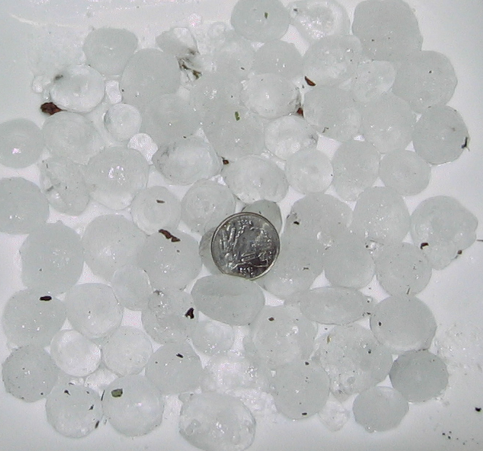
The strongest thunderstorm of the day occurred around 2 P.M. PST in the southeastern portion of Santa Cruz County. This particular thunderstorm exhibited signs of moderate to strong rotation as noted on the doppler radar with a northeast movement. In addition, the doppler radar also had strong reflectivities in excess of 70 dBz, which would suggest relatively large hail for this area. As a result, a tornado warning was issued at 2:02 P.M. PST for southeast Santa Cruz and central Santa Clara Counties (see radar animation below). No actual tornado was reported, but two spotters reported quarter size hail (see photo below).
 |
||
|
||
| Local Storm Reports (LSR) |
 NWUS56 KMTR 211500
 LSRMTR

 PRELIMINARY LOCAL STORM REPORT...SUMMARY
 NATIONAL WEATHER SERVICE SAN FRANCISCO CA
 657 AM PST THU JAN 21 2010

 ..TIME...   ...EVENT...      ...CITY LOCATION...     ...LAT.LON...
 ..DATE...   ....MAG....      ..COUNTY LOCATION..ST.. ...SOURCE....
             ..REMARKS..


 0730 AM     NON-TSTM WND GST 1 SSW HALF MOON BAY     37.46N 122.44W
 01/20/2010  M54.00 MPH       PZZ545             CA   TRAINED SPOTTER

 0900 AM     FLASH FLOOD      4 WSW SEBASTOPOL        38.38N 122.89W
 01/20/2010                   SONOMA             CA   TRAINED SPOTTER

             REPORT FROM COCORAHS OBSERVER...BODEGA HWY FLOODED WITH 6
             INCHES OF FLOWING WATER OVER ROAD.

 0900 AM     HAIL             5 ENE LOS ALTOS         37.39N 122.00W
 01/20/2010  M0.25 INCH       SANTA CLARA        CA   TRAINED SPOTTER

             HAIL SIZE APPROXIMATELY 3/16 INCH

 0919 AM     TSTM WND GST     4 WSW BURLINGAME        37.56N 122.44W
 01/20/2010  M64.00 MPH       SAN MATEO          CA   MESONET

             OBSERVED AT SPRING VALLEY RAWS. ELEVATION 1075 FEET.

 0930 AM     HAIL             6 N PICO BLANCO CAMPGRO 36.42N 121.81W
 01/20/2010  E0.25 INCH       MONTEREY           CA   PUBLIC

             PEA SIZE HAIL

 0950 AM     HEAVY RAIN       WSW CASTRO VALLEY       37.71N 122.06W
 01/20/2010  M0.42 INCH       ALAMEDA            CA   TRAINED SPOTTER

             FROM COCORAHS OBSERVER...HEAVY RAINFALL 0.42 INCHES IN 20
             MINUTES WITH MINOR FLOODING.

 1020 AM     NON-TSTM WND GST 5 SE DUBLIN             37.67N 121.85W
 01/20/2010  E46.00 MPH       ALAMEDA            CA   TRAINED SPOTTER

             HEAVY RAIN AND GUSTS UP TO 40 KNOTS

 1215 PM     HAIL             4 WNW FELTON            37.06N 122.14W
 01/20/2010  M0.25 INCH       SANTA CRUZ         CA   TRAINED SPOTTER

             SMALL HAIL...PEA SIZE OR LESS

 1235 PM     HAIL             1 ESE SANTA CRUZ        36.97N 122.02W
 01/20/2010  E0.25 INCH       SANTA CRUZ         CA   TRAINED SPOTTER

             PEA SIZE HAIL

 0100 PM     HAIL             MT. HAMILTON            37.34N 121.64W
 01/20/2010  M0.25 INCH       SANTA CLARA        CA   PUBLIC

             LICK OBSERVATORY - PEA SIZE HAIL AND LIGHTNING

 0140 PM     HAIL             4 ENE SANTA CRUZ        36.99N 121.97W
 01/20/2010  M0.25 INCH       SANTA CRUZ         CA   TRAINED SPOTTER

 0145 PM     HAIL             4 ESE BERKELEY          37.86N 122.23W
 01/20/2010  E0.25 INCH       ALAMEDA            CA   TRAINED SPOTTER

             LESS THAN PEA SIZE

 0200 PM     HAIL             4 E CAMPBELL            37.27N 121.88W
 01/20/2010  E0.25 INCH       SANTA CLARA        CA   TRAINED SPOTTER

             3RD OR 4TH BLAST OF HAIL IN LAST HOUR. HVY RAIN


 0207 PM     HAIL             3 N CORRALITOS          37.04N 121.80W
 01/20/2010  E1.00 INCH       SANTA CRUZ         CA   PUBLIC

 0238 PM     HAIL             1 WSW MORGAN HILL       37.13N 121.65W
 01/20/2010  E1.00 INCH       SANTA CLARA        CA   TRAINED SPOTTER

 0630 PM     HAIL             1 SW SAN FRANCISCO      37.77N 122.43W
 01/20/2010  E0.50 INCH       SAN FRANCISCO      CA   TRAINED SPOTTER

             NEAR NOB HILL

 0730 PM     HAIL             3 NE BELMONT            37.54N 122.26W
 01/20/2010  E0.25 INCH       SAN MATEO          CA   TRAINED SPOTTER

             HVY HAIL STORM

 0730 PM     HAIL             4 ENE SANTA CRUZ        36.99N 121.97W
 01/20/2010  E0.25 INCH       SANTA CRUZ         CA   TRAINED SPOTTER

             HVY HAIL SHOWER

 0730 PM     HAIL             2 E SANTA CRUZ          36.97N 122.00W
 01/20/2010  E0.25 INCH       SANTA CRUZ         CA   TRAINED SPOTTER

 0730 PM     HAIL             3 NE BELMONT            37.55N 122.26W
 01/20/2010  E0.50 INCH       SAN MATEO          CA   TRAINED SPOTTER

             ONE INCH THICK ON THE GROUND
MMEHLE