Ohio RFC
River Forecast Center
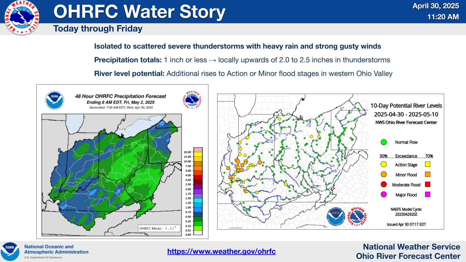
| WATER RESOURCES OUTLOOK NATIONAL WEATHER SERVICE OHIO RIVER FORECAST CENTER WILMINGTON OH 226 PM EST Monday December 30 2024 THE FOLLOWING IS THE 30-DAY WATER RESOURCES OUTLOOK FOR THE MONTH OF JANUARY .WATER RESOURCES STREAMFLOW OUTLOOK... Starting the month of January, streamflows are above normal across most of the Ohio River Valley. Recent rainfall has brought streamflows much above normal in Illinois, Indiana, western Kentucky, and western/northern Ohio. In contrast, southern Pennsylvania, northern West Virginia, eastern Ohio, and central Tennessee have normal to below normal streamflows. The current wet pattern will continue into January, but temperatures will shift much cooler, favoring snowfall over rainfall for much of the month. Multiple rounds of snowfall in the first three weeks of January will aid in bringing the aforementioned below normal streamflow regions in the eastern Ohio Valley back up to normal or above normal streamflows. Near to above normal streamflows should continue across the rest of the Ohio River Valley through January. ..................................................................... .HYDROLOGIC FLOOD AND DROUGHT POTENTIAL... December began relatively dry in the Ohio Valley, but a warm, wet weather pattern returned by the end of the month. Heading into January, temperatures will cool back down, but a relatively active pattern will continue, keeping streamflows up across the region. Widespread cold temperatures are expected heading into the second week of January, bringing a threat for ice jams. Normal to above normal streamflows, regular snowfall, and ice build up on rivers could cause ice jam flooding by the middle of January. The second half of the month appears more normal with mild temperatures and rainfall returning. This in turn could bring snow melt flooding, especially in the northern and eastern Ohio Valley. ..................................................................... .PAST 30 DAY HYDROLOGICAL AND METEOROLOGICAL REVIEW... RAINFALL DEPARTURES... After the recent rainfall, most of the Ohio River Valley received above normal precipitation for the month of December. Western Pennsylvania, southeast Ohio, and the southern tip of the Ohio Valley in central Tennessee only received about 50% of normal precipitation, but everywhere else in the Ohio Valley received about 125%-200% of normal precipitation. Specifically, southeastern Illinois, much of Indiana and Ohio, western Kentucky, and the mountains in Virginia received about twice their normal precipitation for December. https://www.weather.gov/ohrfc/images/dynamic/latest30day.jpeg SOIL MOISTURE CONDITIONS... After a relatively dry latter half of 2024 in the Ohio Valley, soil moisture conditions have been very low compared to normal. In regards to precipitation, a more normal November and December has brought soil moisture up near normal for most of the Ohio Valley. Southeast Ohio, West Virginia, and southern Pennsylvania are still experiencing below normal soil moisture conditions, but the southwestern Ohio Valley now has above normal soil moisture conditions. https://www.cpc.ncep.noaa.gov/soilmst/w.shtml STREAMFLOW CONDITIONS... The entire Ohio Valley except southeast Ohio, northern West Virginia, and southern Pennsylvania has emerged out of the below normal streamflows that plagued the region for the second half of 2024. The rest of the region has normal to above normal streamflows with much of Illinois, Indiana, Ohio, and western Kentucky seeing much above normal streamflow. https://waterdata.usgs.gov/index.php?id=real ..................................................................... .ATMOSPHERIC TELECONNECTION AND OSCILLATION FORECASTS FOR THE NEXT MONTH... TELECONNECTION/OSCILLATION PATTERN ARCTIC OSCILLATION Negative = Below Normal Precipitation NORTH ATLANTIC OSCILLATION Negative = Below Normal Precipitation PACIFIC/NORTH AMERICAN TELECONNECTION Positive = Below Normal Precipitation ENSO - EL NINO/LA NINA OSCILLATION Weak La Nina = Near Normal Precipitation https://www.cpc.ncep.noaa.gov ..................................................................... .TECHNICAL DISCUSSION... The last week of December into the first week of January has been and will be characterized by a warm, wet pattern with the Ohio Valley receiving multiple rounds of significant rainfall. This rain has brought most of the Illinois, Indiana, Ohio, and western Kentucky rivers up into elevated flow. These rivers will remain elevated through at least the first 10 days of January as another potent low pressure system moves through the region bringing frozen precipitation to the north and rain to the south. After the first week of January, the weather pattern shifts cold and slightly more dry. However, multiple rounds of snowfall are expected in the second and third weeks of January, primarily north of the Ohio River and in the high terrain of West Virginia. With the widespread cold temperatures, ice will build on rivers, allowing for potential ice jam flooding. The slow moving rivers in the northwestern Ohio Valley will be especially susceptible to ice jam flooding as the cold air moves in. Nearing the end of January, temperatures should warm back up, bringing rain back to the region along with melting snow. By the end of January, a significant snow pack should be in place in the mountains of West Virginia and the northeastern Ohio Valley. Warm temperatures and rain pose a threat for snow melt flooding in these areas by the end of the month. ....................................................................... VISIT OUR WATER RESOURCES WEBSITE AT http://www.weather.gov/ohrfc/WRO IN ADDITION TO A 30-DAY STREAMFLOW OUTLOOK...YOU CAN ALSO OBTAIN A 60- AND 90-DAY OUTLOOK AT THE WEBSITE $$ |
US Dept of Commerce
National Oceanic and Atmospheric Administration
National Weather Service
Ohio RFC
1901 South State Route 134
Wilmington, OH 45177-9708
Comments? Questions? Please Contact Us.

