Overview
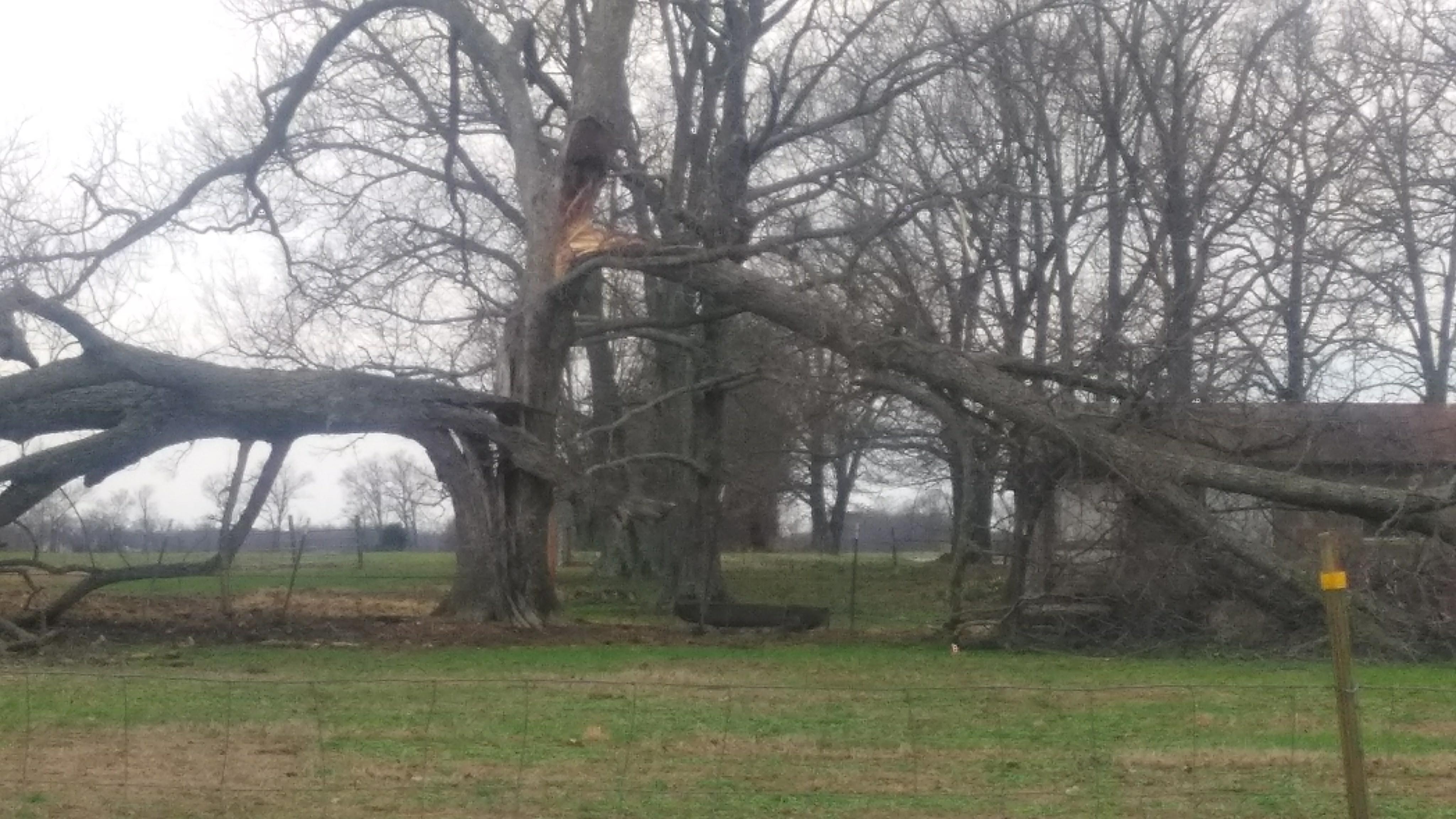
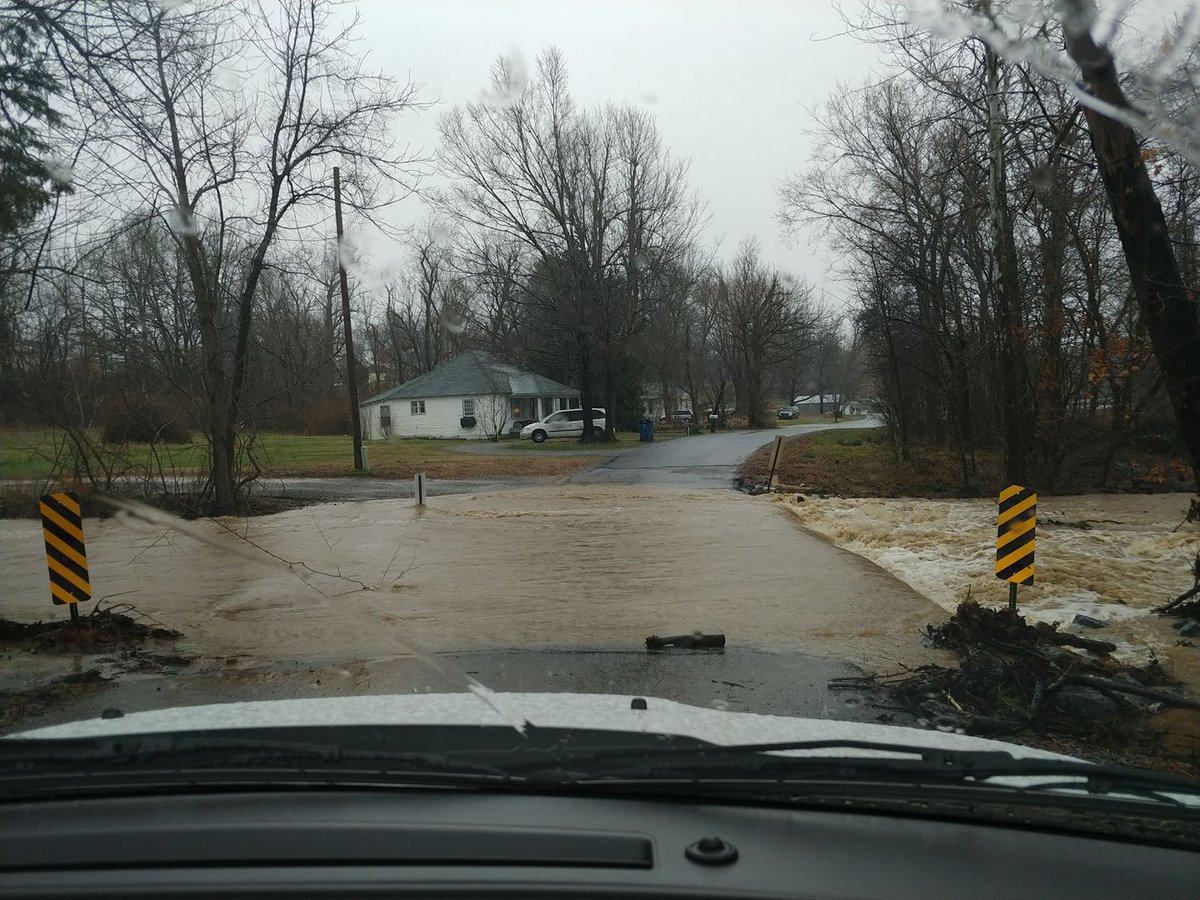
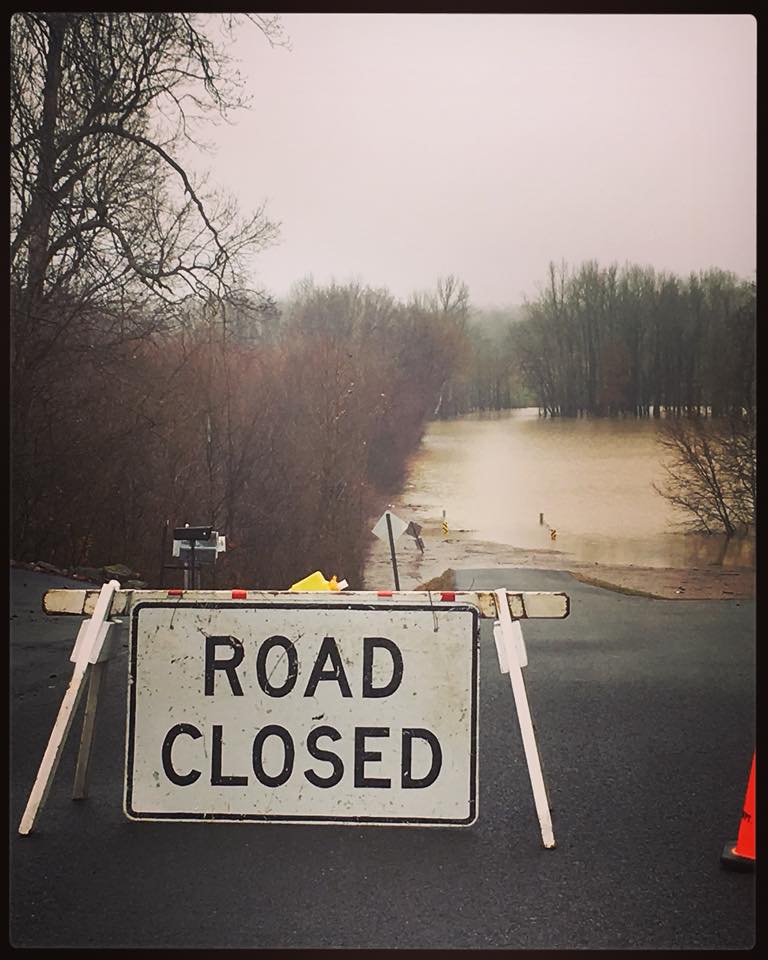
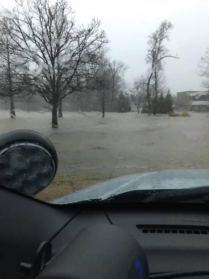
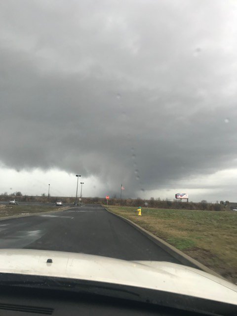
Multiple waves of precipitation moved through our region from the evening of February 20th through the morning of February 24th. A warm front lifted across the region on Saturday afternoon, with showers and thunderstorms forming along it, followed by a cold front that quickly moved through during the late afternoon and evening hours. Severe thunderstorms accompanied this system with damaging winds and numerous tornadoes, including two EF-2 tornadoes that occurred in the Hopkinsville, KY and Matthews, MO areas. There was also widespread flooding across our area due to 5 to 8 inches of rain falling over a 4 to 5 day period. Flash flood warnings were in effect for the vast majority of the region late Saturday afternoon and evening.
Tornadoes:
|
|
||||||||||
|
||||||||||
|
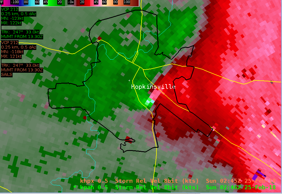
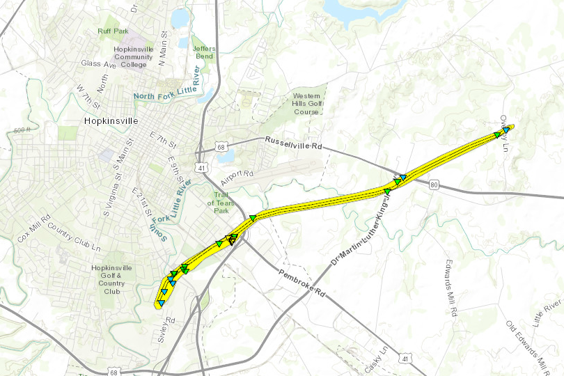
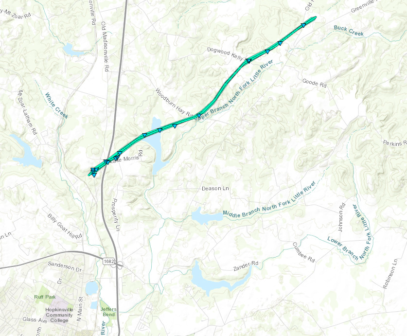
Tornado #1 - Hopkinsville, Kentucky
Track Map (click on map to enlarge)

|
||||||||||||||||
|
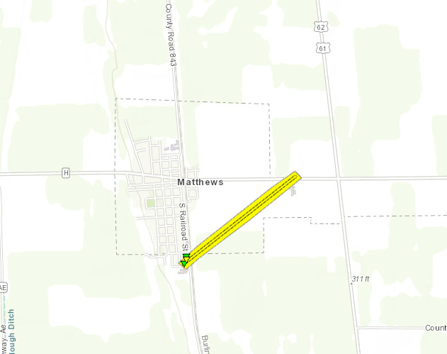
Tornado #2 - Matthews, Missouri
Track Map (click on map to enlarge)
|
||||||||||||||||
|
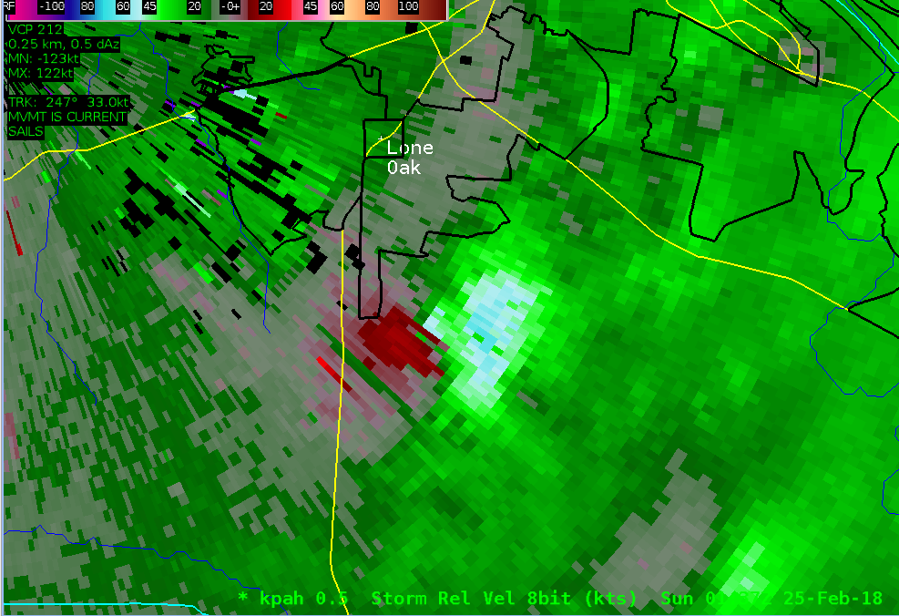
Tornado #3 - Lone Oak, Kentucky
Track Map (click on map to enlarge)
|
||||||||||||||||
|
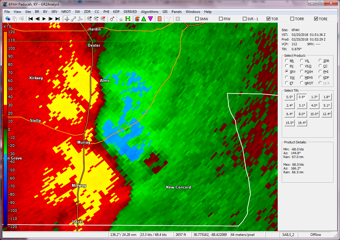
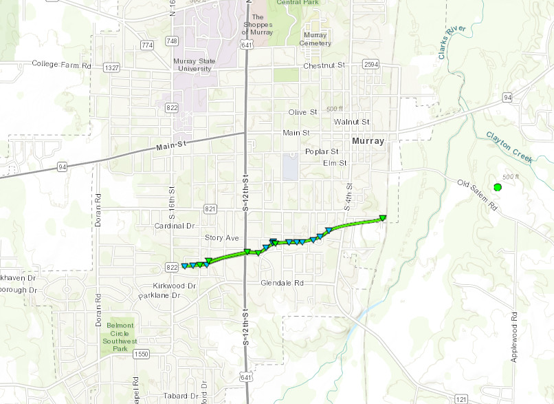
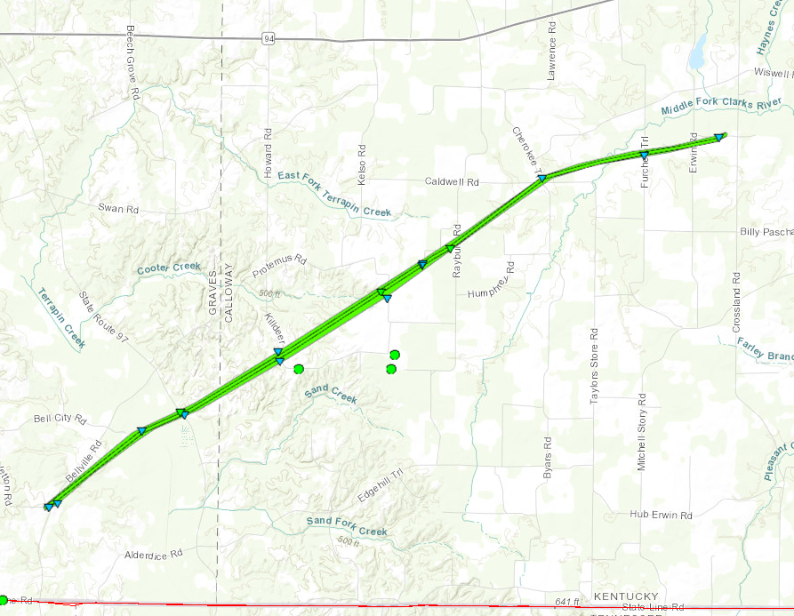
Tornado # 4 - Murray, KY
Track Map (click on map to enlarge)
|
||||||||||||||||
|
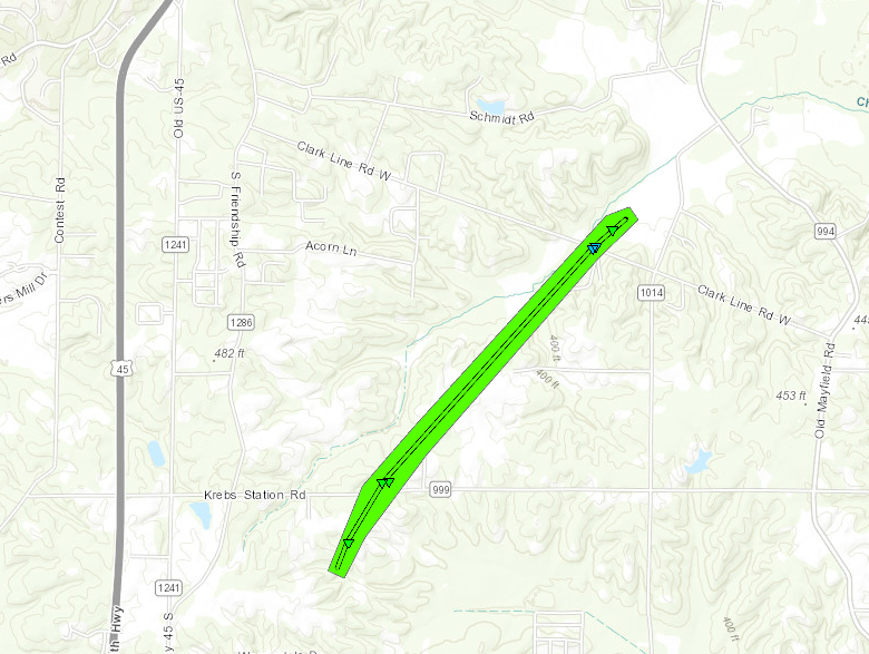
Tornado # 5 - Lake Morris, KY
Track Map (click on map to enlarge)
|
||||||||||||||||
|
Tornado # 6 - Ovil, KY
Track Map (click on map to enlarge)
|
||||||||||||||||
|
Tornado # 7 - West of Murray, KY
Track Map (click on map to enlarge)
|
||||||||||||||||
|
Tornado #8 - Golo, Kentucky
Track Map (click on map to enlarge)
|
||||||||||||||||
|
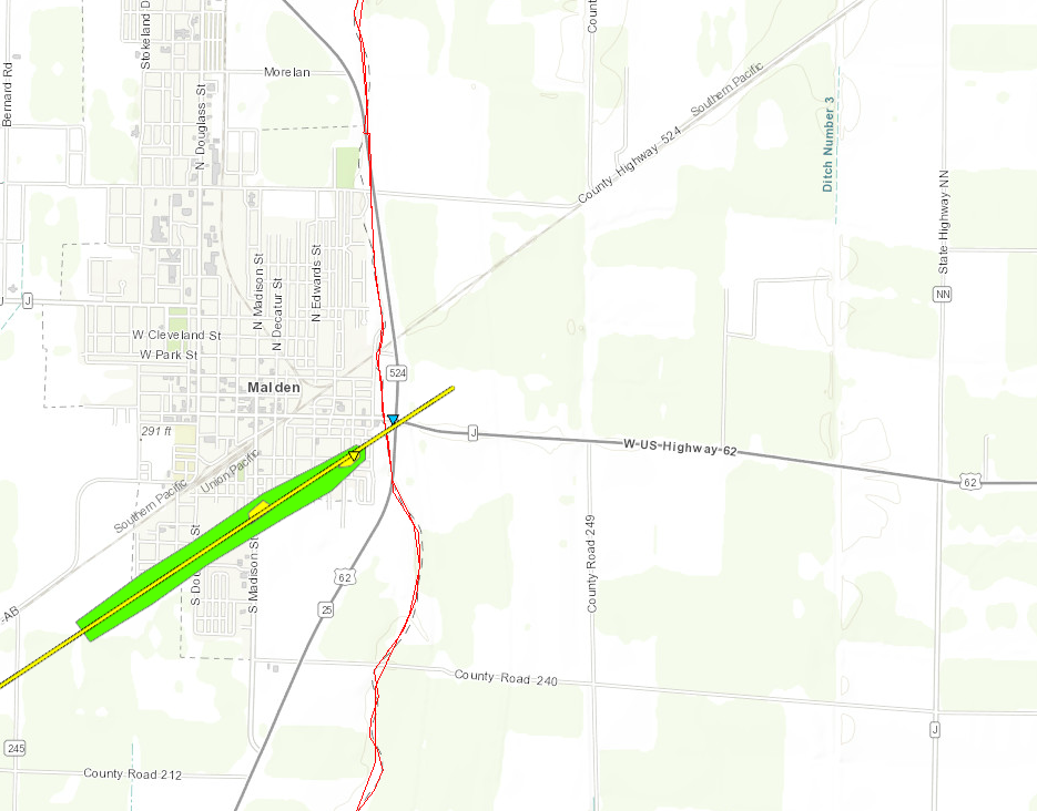
Tornado #9 - Malden, Missouri
Track Map (click on map to enlarge)
|
||||||||||||||||
The Enhanced Fujita (EF) Scale classifies tornadoes into the following categories:
| EF0 Weak 65-85 mph |
EF1 Moderate 86-110 mph |
EF2 Significant 111-135 mph |
EF3 Severe 136-165 mph |
EF4 Extreme 166-200 mph |
EF5 Catastrophic 200+ mph |
 |
|||||
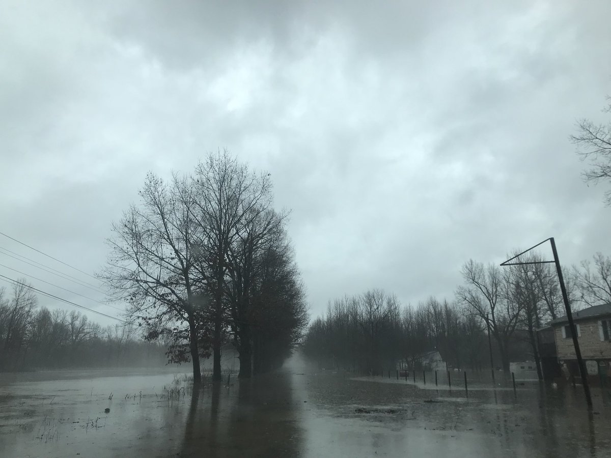
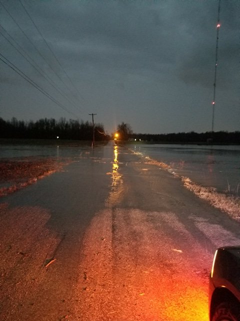
Flooding
Graphic below shows 5 day rainfall totals from Tuesday evening February 20th through the early morning hours on Sunday February 25th.
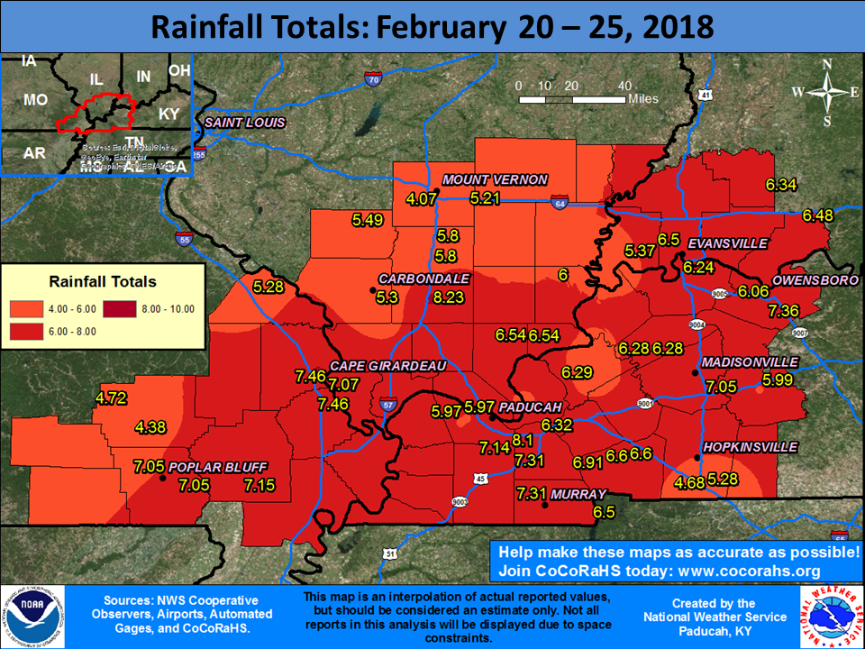 |
|
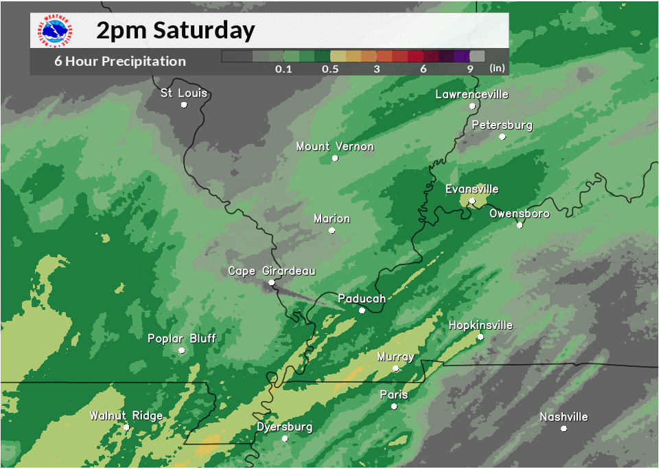
Amounts of 5 to 7 inches were common over this 5 day period, with some totals up around 8 inches. Below is an animation of 6-hour rainfall amounts during the afternoon and evening of February 24. This was the period of strongest thunderstorms and most intense flash flooding. The strip of heaviest rainfall from Poplar Bluff to Cape Girardeau to the Marion/Carbondale area was associated with numerous street closures and several high water rescues. The Cape Girardeau airport measured exactly 3 inches of rain in 4 hours between 3 P.M. and 7 P.M. Disregard the small area of conspicuously low rainfall between Paducah and Cape Girardeau, which was due to an equipment malfunction. |
 |
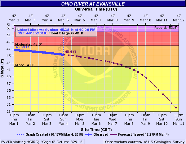
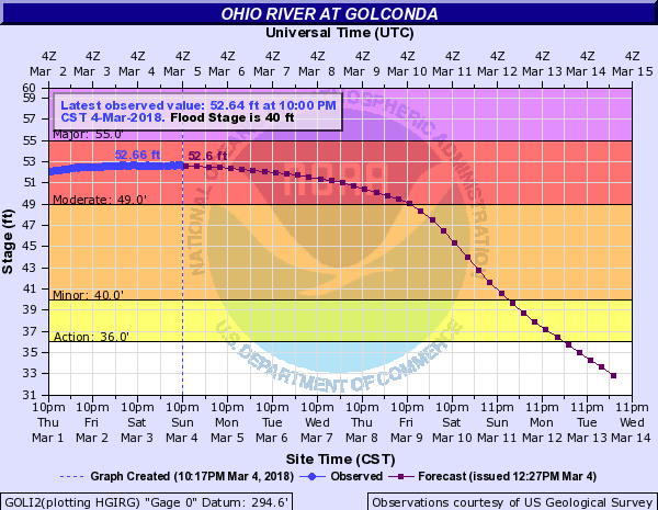
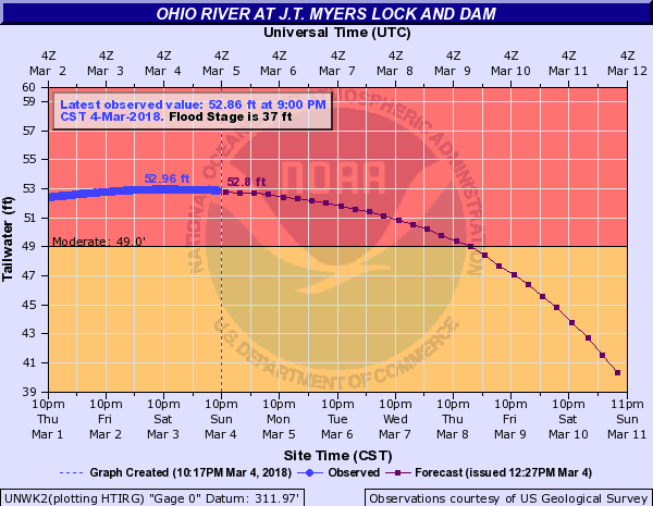
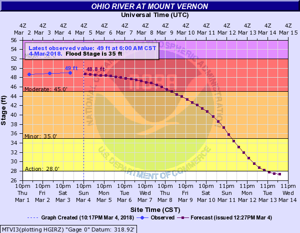
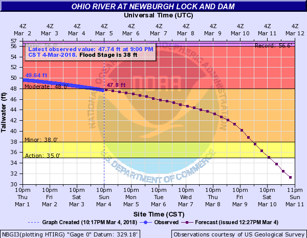
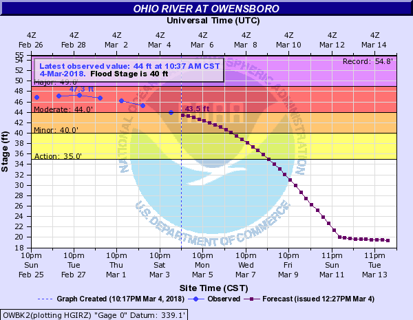
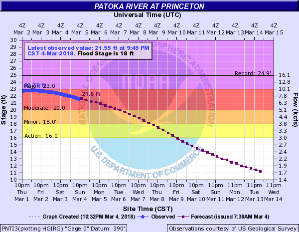
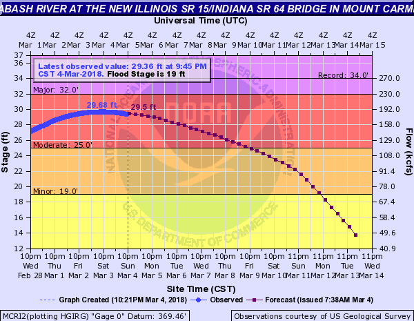
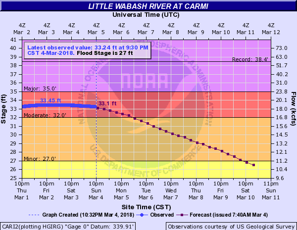
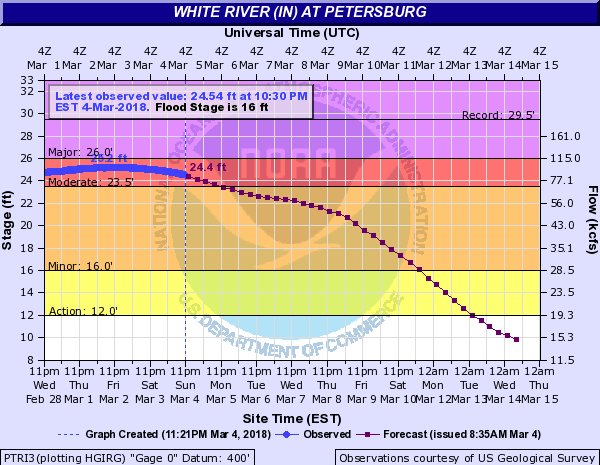
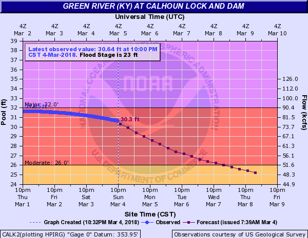
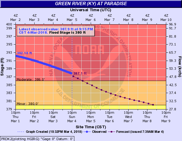
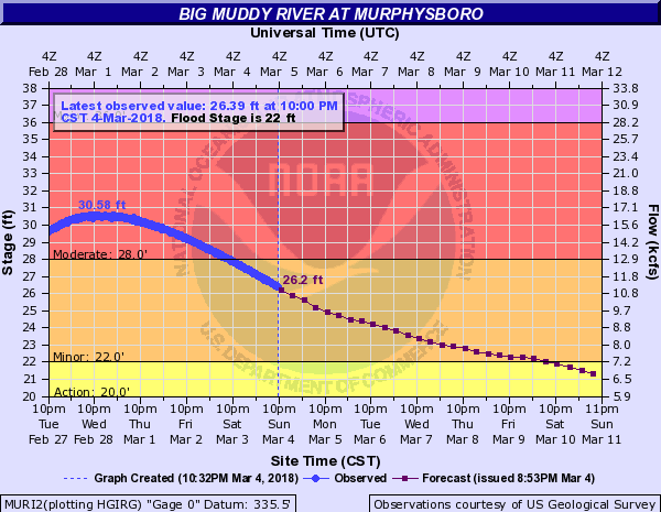
River Flooding
Moderate river flooding occurred at several points along area rivers due to the heavy rainfall in February. Below are some hydrographs from early March, when rivers crested along many rivers. The Ohio River at Evansville, Indiana reached its highest crest since March 10, 1997.
 |
 |
 |
 |
| Ohio River at Evansville crested at 46.87 ft on March 1 |
Ohio River at Golconda crested at 52.66 ft on March 4 |
Ohio River at J.T. Myers Dam crested at 52.96 ft on March 4 |
Ohio River at Mt Vernon Indiana crested at 49.0 ft on March 4 |
 |
 |
 |
 |
| Ohio River at Newburgh crested at 50.1 ft on February 28 |
Ohio River at Owensboro crested at 47.3 ft on February 28 |
Patoka River at Princeton, IN crested at 22.79 ft on March 2 |
Wabash River at Mt Carmel crested at 29.68 ft on March 3 |
 |
 |
 |
 |
| Little Wabash River at Carmi crested at 33.45 ft on March 3 | White River at Petersburg crested at 25.2 ft on March 2 |
Green River at Calhoun crested at 31.67 ft on March 1 |
Green River at Paradise crested at 392.95 ft on February 28 |
 |
|||
| Big Muddy River at Murphysboro crested at 30.58 ft on March 1 |
Photos:
 |
 |
 |
 |
| Tornado damage in Hopkinsville, KY via WHOP Radio | Tornado damage in Hopkinsville, KY via WHOP Radio | Tornado damage in Hopkinsville, KY via WHOP Radio | Tornado damage in Hopkinsville, KY via WHOP Radio |
 |
 |
 |
 |
| Storm damage near Lynn Grove, KY via Murdock Farms & Beau Dodson | Water across Toy York Rd near Benton, KY via Ashley Richardson on Feb 24 | Tornado damage in Matthews, MO via NWS Damage Survey | Tornado damage in Matthews, MO via NWS Damage Survey |
 |
 |
 |
 |
| Hopewell Church Road in Lyon County, KY via LaDonna Knoth around 5:10 PM on Feb 24 | John A Logan campus in Carterville IL via JR Alongi shortly after 5 PM Feb 24 | KY-131 in Symsonia, KY covered by water via Jacob Woods on Feb 24 | Water across Strawberry Rd in Massac County, IL via Bobby Norwood around 610 PM Feb 24 |
 |
|||
| Storm structure of tornado warned cell in Christian County, KY around 2:15 PM on Feb 24 via Dena W. Conway |
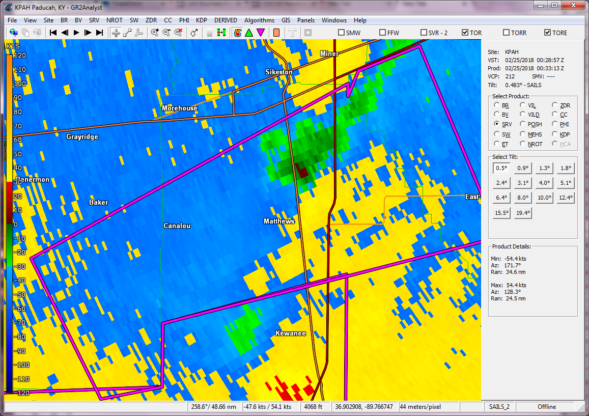
Radar:
Click here for a radar loop of this event
 |
 |
 |
 |
| SRM near Matthews, MO around 6:30 PM | SRM near Lone Oak, KY around 7:40 PM | SRM over Murray, KY around 7:50 PM | SRM over Hopkinsville, KY around 8:45 PM |
Storm Reports
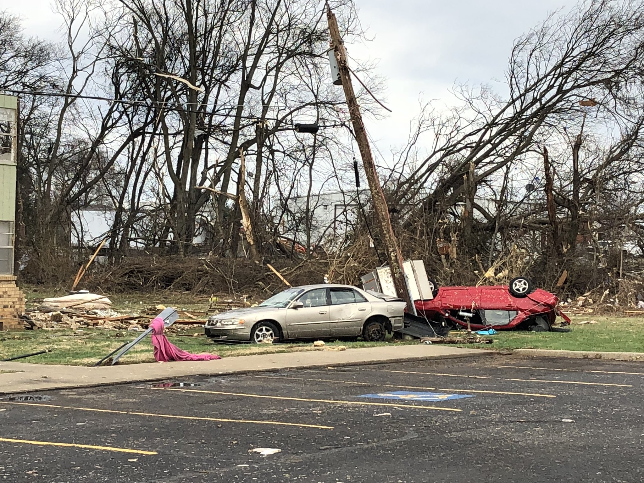
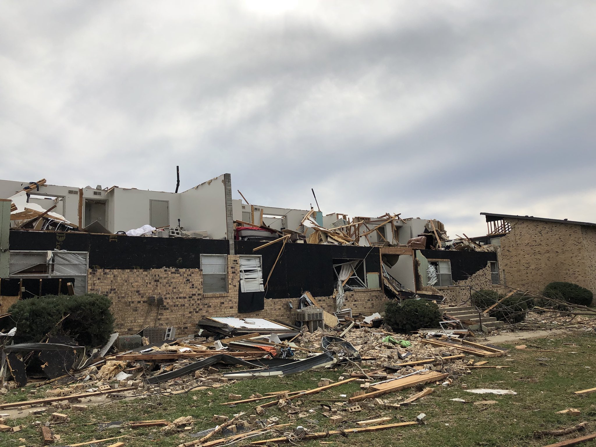
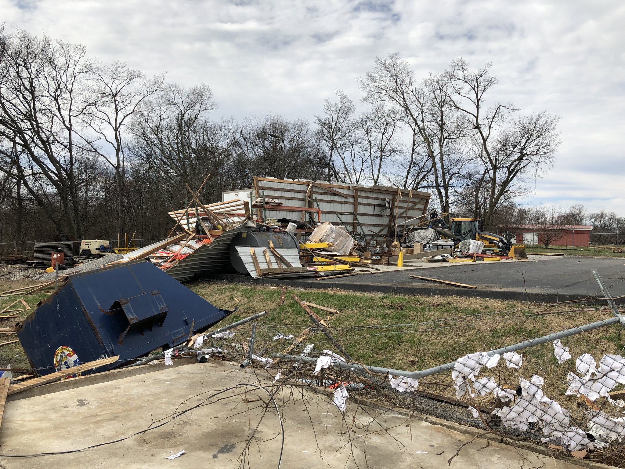
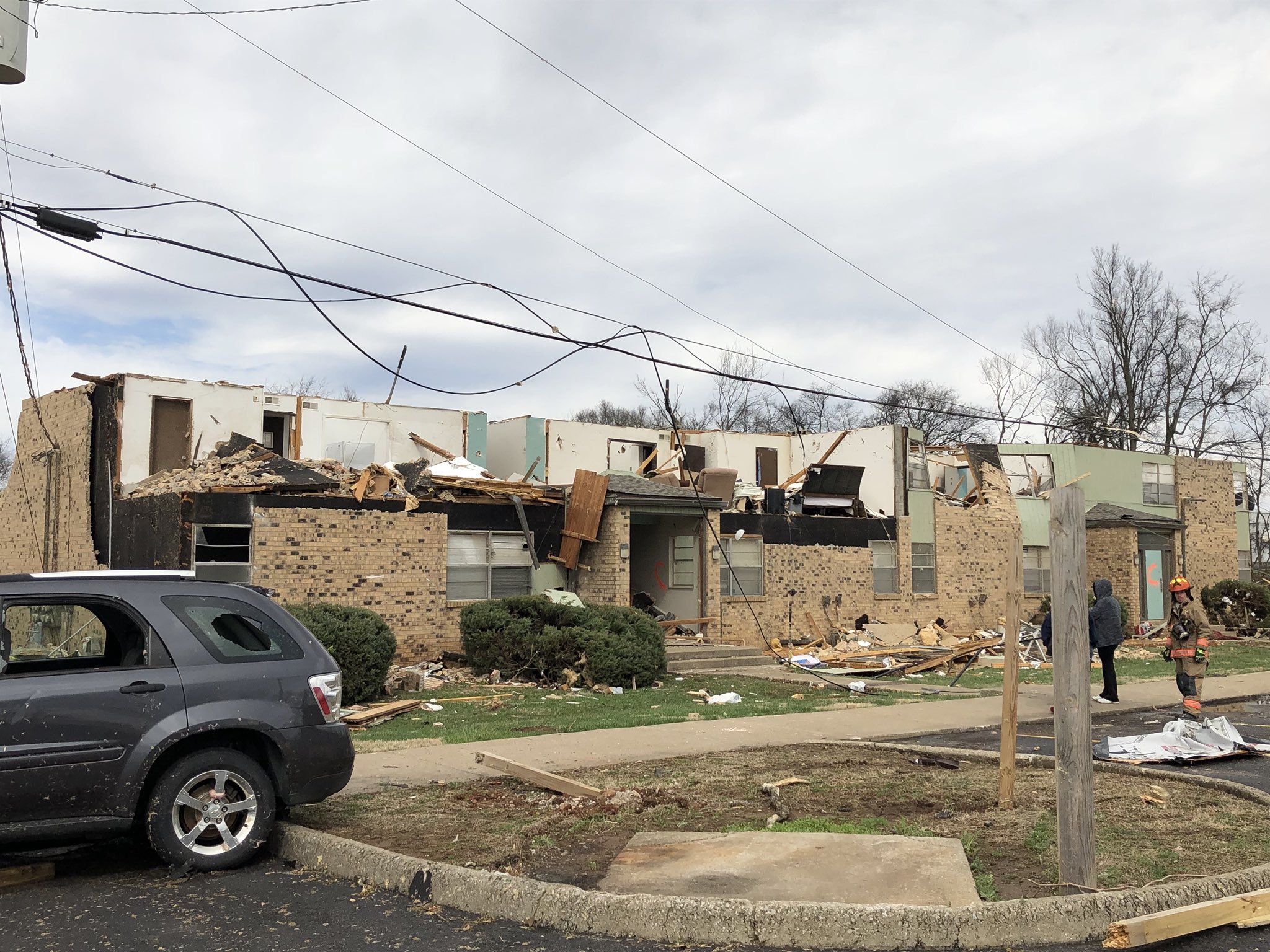
PRELIMINARY LOCAL STORM REPORT...SUMMARY NATIONAL WEATHER SERVICE PADUCAH KY 829 PM CST SUN FEB 25 2018 ..TIME... ...EVENT... ...CITY LOCATION... ...LAT.LON... ..DATE... ....MAG.... ..COUNTY LOCATION..ST.. ...SOURCE.... ..REMARKS.. 1134 AM HEAVY RAIN EDDYVILLE 37.08N 88.08W 02/24/2018 M6.07 INCH LYON KY PUBLIC 4 DAY RAINFALL TOTAL RELAYED VIA TWITTER 0212 PM HAIL 6 E PRINCETON 37.11N 87.78W 02/24/2018 E0.88 INCH CALDWELL KY PUBLIC NICKEL SIZED HAIL REPORTED AT HWY 672. 0440 PM FLASH FLOOD CARBONDALE 37.72N 89.22W 02/24/2018 JACKSON IL TRAINED SPOTTER PLEASANT HILL RD AND MCLAFFERTY RD BEING BLOCKED OFF DUE TO FLOODING. EAST WALNUT ST. AND BIGLER ROAD ALSO REPORTED AS FLOODED. 0449 PM FLASH FLOOD ROMBAUER 36.84N 90.28W 02/24/2018 BUTLER MO TRAINED SPOTTER WATER OVER ROADWAY ON COUNTY ROAD 569. 0449 PM FLASH FLOOD POPLAR BLUFF 36.76N 90.41W 02/24/2018 BUTLER MO LAW ENFORCEMENT ROXIE ROAD NEAR MAUD STREET IMPASSIBLE DUE TO FLOODING. 0503 PM HEAVY RAIN NE CAPE GIRARDEAU 37.31N 89.55W 02/24/2018 M0.00 INCH CAPE GIRARDEAU MO TRAINED SPOTTER 3.7 INCHES OF RAIN SINCE 2PM SATURDAY. 0510 PM FLASH FLOOD WEST FRANKFORT 37.90N 88.93W 02/24/2018 FRANKLIN IL TRAINED SPOTTER SPOTTER REPORTED WATER OVER PARTS OF HWY 149 AND NEARBY SIDE ROADS. 0525 PM FLASH FLOOD SE MARION 37.73N 88.94W 02/24/2018 WILLIAMSON IL TRAINED SPOTTER NUMEROUS ROADS FLOODED AROUND MARION. 0529 PM FLASH FLOOD SW CARBONDALE 37.72N 89.22W 02/24/2018 JACKSON IL TRAINED SPOTTER COUNTRY CLUB ROAD AT HARRIS GLEN ROAD FLOODED WITH SMALL TREES OVER THE ROAD 0540 PM FLASH FLOOD 3 S HENDRICKSON 36.86N 90.47W 02/24/2018 BUTLER MO BROADCAST MEDIA TOWERS ROAD AT RIPPLE LANE COMPLETELY UNDER WATER WITH PARTS OF THE ROAD WASHING OUT QUICKLY. 0555 PM FLASH FLOOD CREAL SPRINGS 37.62N 88.84W 02/24/2018 WILLIAMSON IL FIRE DEPT/RESCUE SEVERAL ROADS IN THE SOUTHERN PORTION OF WILLIAMSON COUNTY QUICKLY BECOMING IMPASSABLE. 0604 PM FLASH FLOOD 2 NW BROOKPORT 37.15N 88.65W 02/24/2018 MASSAC IL PUBLIC PUBLIC REPORT OF WATER OVER STRAWBERRY ROAD. 0618 PM FLASH FLOOD THOMPSONVILLE 37.91N 88.76W 02/24/2018 FRANKLIN IL PUBLIC SEVERAL ROADS REPORTED IMPASSABLE IN THE SE PORTION OF FRANKLIN CO. 0630 PM TORNADO MATTHEWS 36.76N 89.58W 02/24/2018 NEW MADRID MO NWS STORM SURVEY *** 2 INJ *** NWS STORM SURVEY REVEALS EF-2 TORNADO DAMAGE OCCURRED FROM SOUTH SIDE OF MATTHEWS TO 1 MILE EAST OF TOWN. PATH LENGTH OF 1 MILE WITH MAX WIDTH OF 150 YARDS. PEAK WINDS ESTIMATED AT 120 MPH. DOZENS OF HOMES WITH ROOFS PARTIALLY OR COMPLETELY TORN OFF. SEMI TRUCKS WERE BLOWN OVER AND DESTROYED. NUMEROUS BUILDINGS WERE DESTROYED. EXACT NUMBER OF INJURIES NOT KNOWN AT THIS TIME, BUT THERE WERE AT LEAST A FEW MINOR INJURIES DUE TO WINDOWS BEING BLOWN OUT OF REST HOME. 0650 PM TSTM WND DMG MATTHEWS 36.76N 89.58W 02/24/2018 NEW MADRID MO LAW ENFORCEMENT REPORTS OF WINDOWS BLOWN OUT AND DAMAGE TO SEVERAL HOMES, CARS, AND AN OVERTURNED SEMI TRUCK IN MATTHEWS. 0655 PM TSTM WND DMG MATTHEWS 36.76N 89.58W 02/24/2018 NEW MADRID MO BROADCAST MEDIA STRUCTURE AND WIND DAMAGE REPORTED NEAR MATTHEWS. 0655 PM TSTM WND DMG OWENSVILLE 38.27N 87.69W 02/24/2018 GIBSON IN TRAINED SPOTTER NUMEROUS SMALL LIMBS AND SMALL TREES DOWN IN TOWN. WIND ESTIMATED AT LEAST 60 MPH. LATE REPORT. 0655 PM FLASH FLOOD EVANSVILLE 37.98N 87.54W 02/24/2018 VANDERBURGH IN PUBLIC HIGH WATER RESCUE HAPPENING AT CHRIST ROAD AND KENTUCKY AVE. 0708 PM HAIL BARLOW 37.05N 89.05W 02/24/2018 M0.25 INCH BALLARD KY EMERGENCY MNGR 0751 PM TORNADO SW MURRAY 36.61N 88.32W 02/24/2018 CALLOWAY KY NWS STORM SURVEY NWS STORM SURVEY REVEALS EF-1 TORNADO WITH PEAK WINDS OF 105 MPH OCCURRED IN SOUTH PART OF MURRAY. PATH LENGTH ABOUT 1.5 MILES. MAX PATH WIDTH ABOUT 100 YARDS. AT LEAST 40 HOMES DAMAGED, PRIMARILY DUE TO SHINGLE LOSS. TWO HOMES WERE A TOTAL LOSS, WITH ROOF DECKING REMOVED, WINDOWS BLOWN OUT, AND PART OF AN EXTERIOR WALL CAVED IN DUE TO PROJECTILE IMPACTS. AT LEAST FOUR BUSINESSES DAMAGED. DOZENS OF TREES DOWNED. 0756 PM TSTM WND DMG MURRAY 36.61N 88.32W 02/24/2018 CALLOWAY KY EMERGENCY MNGR POWER OUTAGES REPORTED IN MURRAY AND AT THE MURRAY STATE CAMPUS. 0800 PM TSTM WND DMG 1 SW BENTON 36.84N 88.37W 02/24/2018 MARSHALL KY PUBLIC TREE INSIDE A HOME ON THE SOUTHWEST SIDE OF BENTON. 0820 PM TSTM WND DMG 5 NW CADIZ 36.92N 87.89W 02/24/2018 TRIGG KY LAW ENFORCEMENT TREE REPORTED DOWN BLOCKING BOTH LANES OF ROAD NEAR INTERSECTION OF REDDICK POND ROAD AND WILL JACKSON ROAD. TIME APPROXIMATED BY RADAR. 0822 PM TSTM WND DMG S MURRAY 36.61N 88.32W 02/24/2018 CALLOWAY KY EMERGENCY MNGR ROOF AND WINDOW DAMAGE TO A COMMERCIAL BUILDING ON THE EAST SIDE OF 12TH ST, SOUTH OF SYCAMORE ST. 0822 PM TSTM WND DMG MURRAY 36.61N 88.32W 02/24/2018 CALLOWAY KY PUBLIC WIDESPREAD TREE DAMAGE, POWER OUTAGES, AND WINDOWS BLOWN OUT AT FOOD GIANT. 0836 PM TSTM WND DMG MURRAY 36.61N 88.32W 02/24/2018 CALLOWAY KY PUBLIC TREES DOWN AND ROOF DAMAGE ON 16TH ST. IN MURRAY. 0844 PM TORNADO 2 SE HOPKINSVILLE 36.83N 87.47W 02/24/2018 CHRISTIAN KY NWS STORM SURVEY *** 9 INJ *** NWS STORM SURVEY REVEALS EF-2 TORNADO WITH PEAK WINDS OF 135 MPH OCCURRED FROM THE SOUTH SIDE OF HOPKINSVILLE TO 5.5 MILES EAST OF HOPKINSVILLE. PATH LENGTH WAS APPROXIMATELY 5.8 MILES AND PEAK WIDTH WAS 200 YARDS. ALL OF THE INJURIES OCCURRED IN AN APARTMENT COMPLEX. THREE APARTMENT BUILDINGS WERE DESTROYED WITH THE ROOF AND MOST WALLS BLOWN DOWN ON THE SECOND STORY. AT LEAST 4 RETAIL BUILDING SUSTAINED MAJOR ROOF AND SIDING DAMAGE WITH WINDOWS AND DOORS BLOWN IN OR BROKEN. 0845 PM TSTM WND DMG HOPKINSVILLE 36.85N 87.49W 02/24/2018 CHRISTIAN KY BROADCAST MEDIA STRUCTURAL DAMAGE AT EAGLE CROSSING APARTMENTS ON CALVIN DRIVE. REPORTS OF MULTIPLE NON-LIFE-THREATENING INJURIES. TIME APPROXIMATED BY RADAR. 0845 PM TSTM WND DMG HOPKINSVILLE 36.85N 87.49W 02/24/2018 CHRISTIAN KY EMERGENCY MNGR NUMEROUS BUILDINGS WITH DAMAGE INCLUDING A KMART AND THE SECOND STORY OF AN APARTMENT COMPLEX, SEVERAL POWER OUTAGES IN THE HOPKINSVILLE AREA. TIME APPROXIMATED BY RADAR. 0913 PM FLASH FLOOD OWENSBORO 37.76N 87.12W 02/24/2018 DAVIESS KY EMERGENCY MNGR STREET FLOODING IN OWENSBORO WITH MANHOLE COVERS POPPED. 0914 PM NON-TSTM WND DMG 1 S MURRAY 36.60N 88.32W 02/24/2018 CALLOWAY KY PUBLIC WINDOWS BLOWN OUT OF HOMES AND TREES DOWN ON EARL COURT. 0930 PM FLASH FLOOD 5 ESE UNIONTOWN 37.75N 87.85W 02/24/2018 UNION KY BROADCAST MEDIA *** 1 FATAL *** WATER RESCUE NEAR HIGHWAY 359 AND HITESVILLE ROAD IN UNION COUNTY FOR SUBMERGED VEHICLE. FATALITY DISCOVERED IN PROCESS OF RECOVERY OF VEHICLE BY HENDERSON KY FIRE DEPARTMENT AND OTHER AGENCIES. AGE AND GENDER UNKNOWN AT THIS TIME. REPORT FROM EVANSVILLE AREA BROADCAST MEDIA WEBSITES. 0948 PM HEAVY RAIN WEST PADUCAH 37.08N 88.74W 02/24/2018 M2.10 INCH MCCRACKEN KY TRAINED SPOTTER 2.1 INCHES OF RAIN MEASURED SINCE MIDNIGHT. 0948 PM FLASH FLOOD 3 NW WAVERLY 37.74N 87.85W 02/24/2018 UNION KY BROADCAST MEDIA WATER RESCUE ON HWY 359 AND HITESVILLE ROAD. 0952 PM TSTM WND DMG 2 SSE HOPKINSVILLE 36.83N 87.48W 02/24/2018 CHRISTIAN KY EMERGENCY MNGR ROOF DAMAGE TO THE AUDIO SPECIALISTS BUILDING ON FT. CAMPBELL BLVD. 1000 PM HEAVY RAIN SE EVANSVILLE 37.98N 87.54W 02/24/2018 M3.30 INCH VANDERBURGH IN TRAINED SPOTTER 3.3 INCHES OF RAIN REPORTED SINCE MIDNIGHT. 1025 PM HEAVY RAIN NEWBURGH 37.95N 87.40W 02/24/2018 M2.70 INCH WARRICK IN TRAINED SPOTTER 2.7 INCHES OF RAIN REPORTED IN NEWBURGH SINCE MIDNIGHT. 1038 PM FLASH FLOOD 4 WNW DIXON 37.54N 87.76W 02/24/2018 WEBSTER KY EMERGENCY MNGR WATER OVER THE ROAD AT STATE ROUTE 132 WEST NEAR STATE ROUTE 857. 1057 PM TSTM WND DMG LYNN GROVE 36.59N 88.44W 02/24/2018 CALLOWAY KY PUBLIC FARM DAMAGE REPORTED IN LYNN GROVE. 1100 PM FLASH FLOOD 3 NE MOSELEYVILLE 37.69N 87.15W 02/24/2018 DAVIESS KY TRAINED SPOTTER ROUTE 554 FLOODED JUST EAST OF TODD BRIDGE ROAD. 1127 PM FLOOD EVANSVILLE 37.98N 87.54W 02/24/2018 VANDERBURGH IN COUNTY OFFICIAL HEAVY RAIN HAS CAUSED A SINKHOLE TO OPEN ON LOCUST STREET BETWEEN THIRD AND FOURTH STREETS IN EVANSVILLE. REPORTED BY DEPUTY MAYOR VIA TWITTER. 1151 PM FLASH FLOOD GROSS 37.53N 88.29W 02/24/2018 HARDIN IL BROADCAST MEDIA WATER RESCUES ONGOING IN HARDIN COUNTY. 0425 AM FLASH FLOOD 5 N OWENSVILLE 38.34N 87.69W 02/25/2018 GIBSON IN TRAINED SPOTTER STATE ROAD 65 WASHED OUT NEAR THE 25 MILE MARKER NORTH OF OWENSVILLE. SOME GRAVEL ROADS IN THE AREA WASHED OUT. LATE REPORT. 0454 AM HEAVY RAIN EVANSVILLE 37.98N 87.54W 02/25/2018 M3.60 INCH VANDERBURGH IN TRAINED SPOTTER 24 HOUR RAINFALL TOTAL FROM ANGEL MOUNDS AREA. STORM TOTAL FOR ENTIRE EVENT WAS 7.1 INCHES. 0800 AM HEAVY RAIN 4 SW CHANDLER 38.00N 87.42W 02/25/2018 M6.66 INCH WARRICK IN COCORAHS 5 DAY RAINFALL TOTAL 0800 AM HEAVY RAIN 5 SW OWENSBORO 37.71N 87.18W 02/25/2018 M6.06 INCH DAVIESS KY ASOS 5 DAY RAINFALL TOTAL AT OWENSBORO AIRPORT 0800 AM HEAVY RAIN HENDERSON 37.84N 87.58W 02/25/2018 M6.24 INCH HENDERSON KY COCORAHS 5 DAY RAINFALL TOTAL 0800 AM HEAVY RAIN FAIRFIELD 38.38N 88.37W 02/25/2018 M5.79 INCH WAYNE IL PUBLIC 5 DAY RAINFALL TOTAL 0800 AM HEAVY RAIN NORTONVILLE 37.19N 87.46W 02/25/2018 M7.05 INCH HOPKINS KY PUBLIC 5 DAY RAINFALL TOTAL 0800 AM HEAVY RAIN HICKSVILLE 36.80N 88.50W 02/25/2018 M7.31 INCH GRAVES KY PUBLIC 5 DAY RAINFALL TOTAL 0800 AM HEAVY RAIN 2 N BOONVILLE 38.07N 87.27W 02/25/2018 M6.80 INCH WARRICK IN COCORAHS 5 DAY RAINFALL TOTAL 0800 AM HEAVY RAIN CADIZ 36.87N 87.82W 02/25/2018 M7.07 INCH TRIGG KY CO-OP OBSERVER 5 DAY RAINFALL TOTAL 0800 AM HEAVY RAIN STENDAL 38.29N 87.13W 02/25/2018 M6.34 INCH PIKE IN COCORAHS 5 DAY RAINFALL TOTAL 0800 AM HEAVY RAIN DIEHLSTADT 36.96N 89.43W 02/25/2018 E6.80 INCH SCOTT MO TRAINED SPOTTER 5 DAY RAINFALL TOTAL. 0800 AM HEAVY RAIN BELLE RIVE 38.23N 88.74W 02/25/2018 M5.21 INCH JEFFERSON IL COCORAHS 5 DAY RAINFALL TOTAL 0800 AM HEAVY RAIN BENTON 38.01N 88.92W 02/25/2018 M5.80 INCH FRANKLIN IL COCORAHS 5 DAY RAINFALL TOTAL 0800 AM HEAVY RAIN WEST FRANKFORT 37.90N 88.93W 02/25/2018 M5.80 INCH FRANKLIN IL COCORAHS 5 DAY RAINFALL TOTAL 0800 AM HEAVY RAIN 2 SE BUSH 37.82N 89.10W 02/25/2018 M5.76 INCH WILLIAMSON IL COCORAHS 5 DAY RAINFALL TOTAL 0800 AM HEAVY RAIN 2 W CARBONDALE 37.72N 89.25W 02/25/2018 M5.30 INCH JACKSON IL COCORAHS 5 DAY RAINFALL TOTAL 0800 AM HEAVY RAIN 2 W DEXTER 36.74N 88.33W 02/25/2018 M7.31 INCH CALLOWAY KY COCORAHS 5 DAY RAINFALL TOTAL 0800 AM HEAVY RAIN 2 NW OAK GROVE 36.69N 87.45W 02/25/2018 M5.28 INCH CHRISTIAN KY PUBLIC 5 DAY RAINFALL TOTAL BETWEEN OAK GROVE AND HERNDON 0800 AM HEAVY RAIN 4 NNE EVANSVILLE 38.04N 87.52W 02/25/2018 M6.00 INCH VANDERBURGH IN ASOS 5 DAY RAINFALL TOTAL AT EVANSVILLE AIRPORT 0800 AM HEAVY RAIN BENTON 36.85N 88.36W 02/25/2018 M5.23 INCH MARSHALL KY PUBLIC 5 DAY RAINFALL TOTAL 0800 AM HEAVY RAIN POPLAR BLUFF 36.76N 90.41W 02/25/2018 M7.05 INCH BUTLER MO ASOS 5 DAY RAINFALL TOTAL AT POPLAR BLUFF AIRPORT 0800 AM HEAVY RAIN SANTA CLAUS 38.12N 86.93W 02/25/2018 M6.48 INCH SPENCER IN COCORAHS 5 DAY RAINFALL TOTAL 0800 AM HEAVY RAIN RIDGWAY 37.80N 88.26W 02/25/2018 M6.00 INCH GALLATIN IL COCORAHS 5 DAY RAINFALL TOTAL 0800 AM HEAVY RAIN MARION 37.73N 88.94W 02/25/2018 M8.23 INCH WILLIAMSON IL PUBLIC 5 DAY RAINFALL TOTAL 0800 AM HEAVY RAIN BERNIE 36.67N 89.97W 02/25/2018 M7.15 INCH STODDARD MO TRAINED SPOTTER 5 DAY RAINFALL TOTAL 0800 AM HEAVY RAIN ST. PHILLIP 37.99N 87.72W 02/25/2018 M6.50 INCH POSEY IN PUBLIC 5 DAY RAINFALL TOTAL 0800 AM HEAVY RAIN 6 SW CAPE GIRARDEAU 37.25N 89.63W 02/25/2018 M7.46 INCH CAPE GIRARDEAU MO ASOS 5 DAY RAINFALL TOTAL AT CAPE GIRARDEAU MO AIRPORT 0800 AM HEAVY RAIN CARBONDALE 37.72N 89.22W 02/25/2018 M4.72 INCH JACKSON IL PUBLIC 5 DAY RAINFALL TOTAL 0800 AM HEAVY RAIN SALEM 37.27N 88.24W 02/25/2018 M6.29 INCH LIVINGSTON KY COCORAHS 5 DAY RAINFALL TOTAL 0800 AM HEAVY RAIN NEW CONCORD 36.60N 88.07W 02/25/2018 M6.50 INCH CALLOWAY KY PUBLIC 5 DAY RAINFALL TOTAL 0800 AM HEAVY RAIN PROVIDENCE 37.40N 87.75W 02/25/2018 M6.28 INCH WEBSTER KY CO-OP OBSERVER 5 DAY RAINFALL TOTAL 0800 AM HEAVY RAIN 5 NW ROSICLARE 37.47N 88.42W 02/25/2018 M6.54 INCH POPE IL CO-OP OBSERVER 5 DAY RAINFALL TOTAL 0800 AM HEAVY RAIN 4 SW CADIZ 36.83N 87.87W 02/25/2018 M6.60 INCH TRIGG KY CO-OP OBSERVER 5 DAY RAINFALL TOTAL 0800 AM HEAVY RAIN 4 N BENTON 36.91N 88.36W 02/25/2018 M6.00 INCH MARSHALL KY MESONET 5 DAY RAINFALL TOTAL AT KY MESONET SITE 0800 AM HEAVY RAIN RIDGWAY 37.80N 88.26W 02/25/2018 M7.86 INCH GALLATIN IL PUBLIC 5 DAY RAINFALL TOTAL 0800 AM HEAVY RAIN 2 N CAPE GIRARDEAU 37.34N 89.55W 02/25/2018 M8.08 INCH CAPE GIRARDEAU MO COCORAHS 5 DAY RAINFALL TOTAL 0800 AM HEAVY RAIN GRAND RIVERS 37.01N 88.24W 02/25/2018 M6.75 INCH LIVINGSTON KY PUBLIC 3 DAY RAINFALL TOTAL 0800 AM HEAVY RAIN CALVERT CITY 37.03N 88.35W 02/25/2018 M6.32 INCH MARSHALL KY NWS EMPLOYEE RAINFALL TOTAL SINCE LAST TUESDAY EVENING. 5 DAY TOTAL. 0800 AM HEAVY RAIN 4 S MADISONVILLE 37.28N 87.51W 02/25/2018 M6.85 INCH HOPKINS KY MESONET 5 DAY RAINFALL TOTAL AT KY MESONET SITE 0800 AM HEAVY RAIN 2 SE PRINCETON 38.34N 87.54W 02/25/2018 M6.41 INCH GIBSON IN MESONET 5 DAY RAINFALL TOTAL AT KY MESONET SITE 0800 AM HEAVY RAIN 1 W MURRAY 36.61N 88.33W 02/25/2018 M6.18 INCH CALLOWAY KY MESONET 5 DAY RAINFALL TOTAL AT KY MESONET SITE 0800 AM HEAVY RAIN 6 N HOPKINSVILLE 36.94N 87.49W 02/25/2018 M5.21 INCH CHRISTIAN KY MESONET 5 DAY RAINFALL TOTAL AT KY MESONET SITE 0800 AM HEAVY RAIN 4 NE MARION 37.37N 88.03W 02/25/2018 M6.63 INCH CRITTENDEN KY MESONET 5 DAY RAINFALL TOTAL AT KY MESONET SITE 0800 AM HEAVY RAIN 2 E HICKMAN 36.56N 89.15W 02/25/2018 M6.49 INCH FULTON KY MESONET 5 DAY RAINFALL TOTAL AT KY MESONET SITE 0800 AM HEAVY RAIN 6 SW GREENVILLE 37.15N 87.26W 02/25/2018 M5.47 INCH MUHLENBERG KY EMERGENCY MNGR 5 DAY RAINFALL TOTAL. 0800 AM HEAVY RAIN 5 E HENDERSON 37.84N 87.49W 02/25/2018 M5.85 INCH HENDERSON KY MESONET 5 DAY RAINFALL TOTAL AT KY MESONET SITE 0800 AM HEAVY RAIN AURORA 36.78N 88.14W 02/25/2018 M6.91 INCH MARSHALL KY CO-OP OBSERVER 5 DAY RAINFALL TOTAL AT KENLAKE RESORT 0800 AM HEAVY RAIN WEST PADUCAH 37.08N 88.74W 02/25/2018 M5.97 INCH MCCRACKEN KY ASOS 5 DAY RAINFALL TOTAL AT PADUCAH BARKLEY AIRPORT 0800 AM HEAVY RAIN 6 N GREENVILLE 37.29N 87.18W 02/25/2018 M6.73 INCH MUHLENBERG KY MESONET 5 DAY RAINFALL TOTAL AT KY MESONET SITE 0800 AM HEAVY RAIN 4 SW CADIZ 36.83N 87.87W 02/25/2018 M6.12 INCH TRIGG KY MESONET 5 DAY RAINFALL TOTAL AT KY MESONET SITE 0800 AM HEAVY RAIN 4 E MORGANFIELD 37.68N 87.83W 02/25/2018 M5.59 INCH UNION KY MESONET 5 DAY RAINFALL TOTAL AT KY MESONET SITE 0800 AM HEAVY RAIN EDDYVILLE 37.08N 88.08W 02/25/2018 M7.40 INCH LYON KY PUBLIC 5 DAY RAINFALL TOTAL. 0800 AM HEAVY RAIN 6 SW MAYFIELD 36.67N 88.72W 02/25/2018 M7.08 INCH GRAVES KY MESONET 5 DAY RAINFALL TOTAL AT KY MESONET SITE 0800 AM HEAVY RAIN 4 SW SYMSONIA 36.86N 88.56W 02/25/2018 M7.14 INCH GRAVES KY TRAINED SPOTTER 5 DAY RAINFALL TOTAL 0800 AM HEAVY RAIN 5 NW CALHOUN 37.59N 87.32W 02/25/2018 M7.41 INCH MCLEAN KY MESONET 5 DAY RAINFALL TOTAL AT KY MESONET SITE 0800 AM HEAVY RAIN 1 E SCOTT CITY 37.22N 89.51W 02/25/2018 M7.07 INCH SCOTT MO COCORAHS 5 DAY RAINFALL TOTAL 0800 AM HEAVY RAIN SYMSONIA 36.90N 88.51W 02/25/2018 M8.10 INCH GRAVES KY PUBLIC 5 DAY RAINFALL TOTAL 0800 AM HEAVY RAIN 5 S OWENSBORO 37.69N 87.12W 02/25/2018 M7.36 INCH DAVIESS KY COCORAHS 5 DAY RAINFALL TOTAL && $$ MY
 |
Media use of NWS Web News Stories is encouraged! Please acknowledge the NWS as the source of any news information accessed from this site. |
|


%202-24-18.png)
%202-24-18.png)