Overview
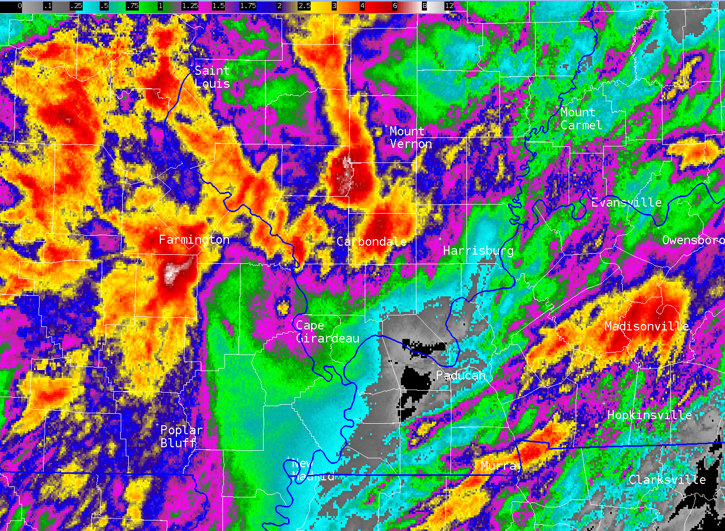
Two waves of heavy rain impacted the Quad State region, with the first occurring from early morning into the afternoon on August 4th. The second round started late evening on the 4th and continued into the morning on August 5th. Pockets of 3-6" of rain occurred across portions of southern Illinois and western Kentucky that resulted in flash flooding. Marion, IL and Central City, KY were among the hardest hit communities. Cars were stranded in submerged water on streets in Marion during the morning of August 4, while a water rescue occurred in the Central City area around 2 AM on August 5.
Photos
 |
 |
.jpeg) |
 |
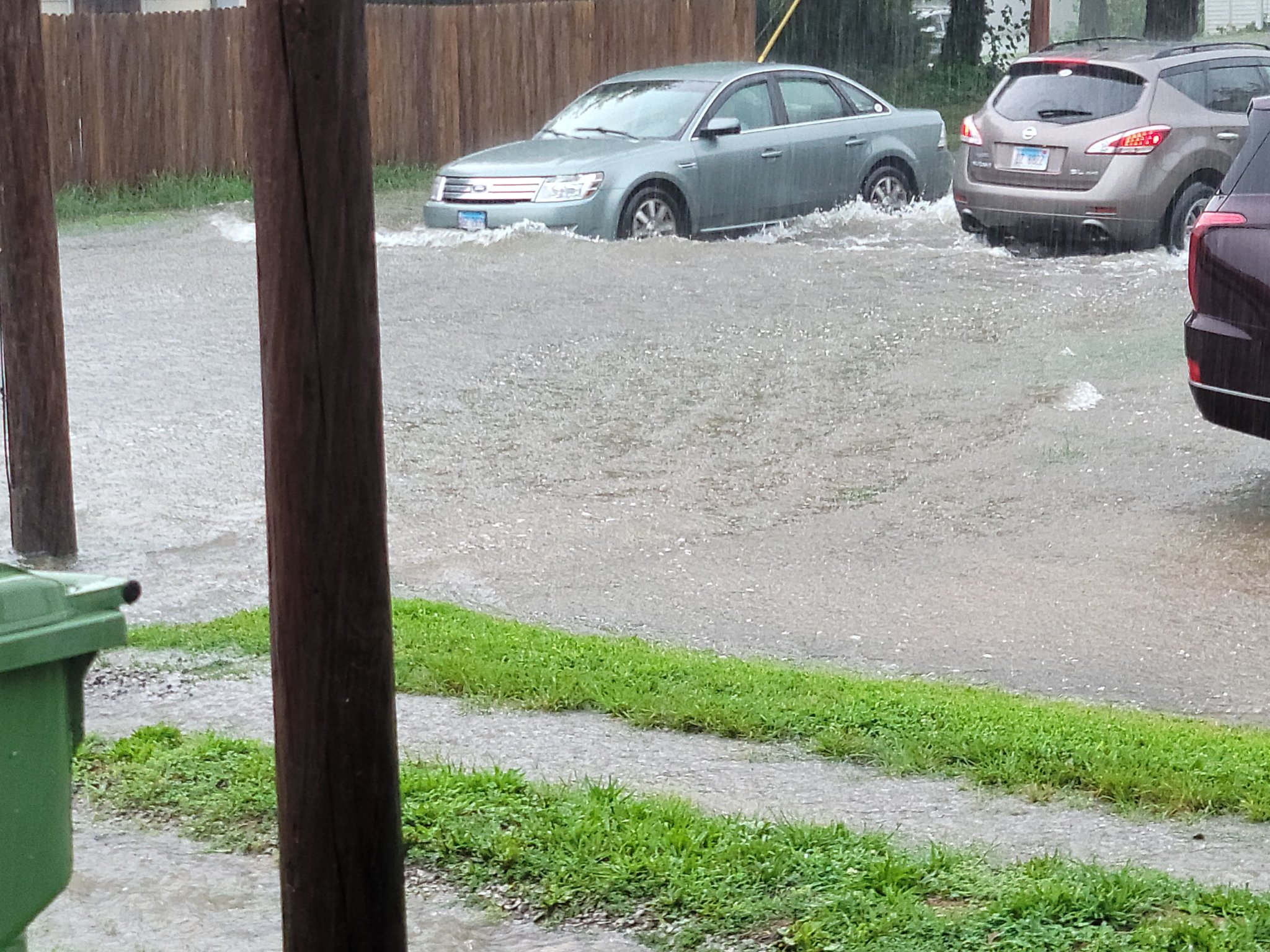
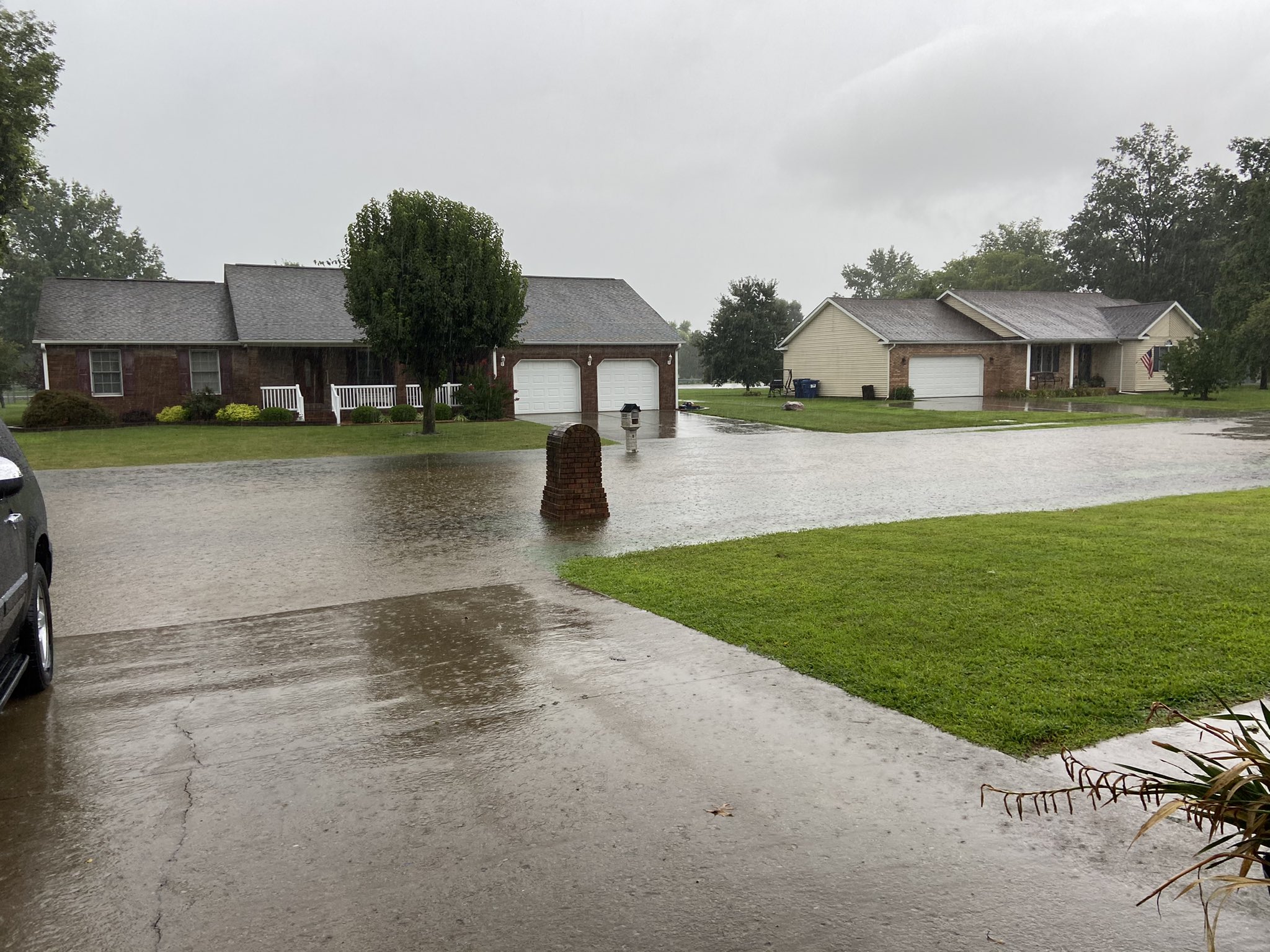
| Street flooding in Johnston City, IL via JJ Diebolt | Street flooding in Marion, IL via Mrs Havener | Flooding at intersection of Hwy 14 and 184 near Mulkeytown, IL via Luke Saeger | Flooding in Mortons Gap, KY via David Fugate |
Radar
Click here for a radar loop of the first part of the event from 12 AM to 4 PM on August 4.
Click here for a radar loop of the second part of the event from 10 PM August 4 - 10 AM August 5.
Storm Reports
PRELIMINARY LOCAL STORM REPORT...SUMMARY
NATIONAL WEATHER SERVICE PADUCAH KY
613 PM CDT THU AUG 4 2022

..TIME...   ...EVENT...      ...CITY LOCATION...     ...LAT.LON...
..DATE...   ....MAG....      ..COUNTY LOCATION..ST.. ...SOURCE....
            ..REMARKS..

1057 AM     FLASH FLOOD      MARION                  37.74N 88.93W
08/04/2022                   WILLIAMSON         IL   TRAINED SPOTTER

            NUMEROUS REPORTS OF STREET FLOODING IN
            MARION. HEAVY RAIN CONTINUES WITH VERY POOR
            VISIBILITY.

1105 AM     FLASH FLOOD      JOHNSTON CITY           37.82N 88.93W
08/04/2022                   WILLIAMSON         IL   TRAINED SPOTTER

            SIGNIFICANT STREET FLOODING ACROSS THE CITY.
            OVER 4 INCHES OF RAIN SINCE MIDNIGHT CDT.

1156 AM     FLASH FLOOD      MARION                  37.75N 88.93W
08/04/2022                   WILLIAMSON         IL   TRAINED SPOTTER

            FIRE AND RESCUE CHECKING ON FLOODED TRAILER
            PARK NEAR PATRICK STREET. SOME PERSONS BEING
            ADVISED TO STAY PUT. ENTIRE PARK FLOODED.

1207 PM     FLASH FLOOD      MARION                  37.73N 88.93W
08/04/2022                   WILLIAMSON         IL   BROADCAST MEDIA

            MAIN STREET ON THE EAST SIDE OF THE MARION
            SQUARE IS NEARLY IMPASSABLE. DAY CARE CENTER
            NEARBY HAS WATER IN CLASSROOMS. IT IS NOW
            CLOSED DOWN.

0115 PM     HEAVY RAIN       1 NNW WHITEASH          37.80N 88.94W
08/04/2022  M5.62 INCH       WILLIAMSON         IL   PUBLIC

            PERSONAL WEATHER STATION. RAINFALL TOTAL
            SINCE MIDNIGHT.

0115 PM     HEAVY RAIN       1 S SPILLERTOWN         37.75N 88.92W
08/04/2022  M5.22 INCH       WILLIAMSON         IL   PUBLIC

            PERSONAL WEATHER STATION. RAINFALL TOTAL
            SINCE MIDNIGHT.

0115 PM     HEAVY RAIN       3 ENE HERRIN            37.82N 88.99W
08/04/2022  M4.41 INCH       WILLIAMSON         IL   PUBLIC

            PERSONAL WEATHER STATION. RAINFALL TOTAL
            SINCE MIDNIGHT.

0115 PM     HEAVY RAIN       CRAINVILLE              37.75N 89.06W
08/04/2022  M3.54 INCH       WILLIAMSON         IL   PUBLIC

            PERSONAL WEATHER STATION. RAINFALL TOTAL
            SINCE MIDNIGHT.

0135 PM     HEAVY RAIN       JOHNSTON CITY           37.82N 88.93W
08/04/2022  M6.00 INCH       WILLIAMSON         IL   TRAINED SPOTTER

            STORM TOTAL SINCE MIDNIGHT. PERSONAL WEATHER
            STATION.

0155 PM     HEAVY RAIN       5 SW MARION             37.68N 89.00W
08/04/2022  M4.67 INCH       WILLIAMSON         IL   MESONET

            12 RAINFALL TOTAL AT MESONET STATION COWI2
            CRAB ORCHARD IL.

0232 PM     FLOOD            3 W NEWBURGH            37.95N 87.46W
08/04/2022                   VANDERBURGH        IN   TRAINED SPOTTER

            MINOR FLOODING REPORTED IN LOW-LYING AND
            POOR DRAINAGE AREAS NEAR ANGEL MOUNDS.

0345 PM     FLASH FLOOD      2 ENE SANTA CLAUS       38.13N 86.90W
08/04/2022                   SPENCER            IN   PUBLIC

            SEVERAL INCHES OF WATER FLOWING THROUGH A
            CAMPGROUND NEAR SANTA CLAUS. FOUND VIA
            SNAPCHAT. TIME IS APPROXIMATE.

0512 PM     FLASH FLOOD      7 NE SANTA CLAUS        38.19N 86.83W
08/04/2022                   SPENCER            IN   EMERGENCY MNGR

            MONTE CASINO ROAD IS FLOODING NORTH OF ST.
            MEINRAD.

0513 PM     FLASH FLOOD      2 E SANTA CLAUS         38.12N 86.89W
08/04/2022                   SPENCER            IN   EMERGENCY MNGR

            COUNTY ROAD 1600 N IS FLOODED NEAR SANTA
            CLAUS.
0139 AM     FLASH FLOOD      CENTRAL CITY            37.29N 87.12W
08/05/2022                   MUHLENBERG         KY   911 CALL CENTER

            SOUTH 2ND STREET IS CLOSED DUE TO FLASH
            FLOODING.

0139 AM     FLASH FLOOD      CENTRAL CITY            37.29N 87.13W
08/05/2022                   MUHLENBERG         KY   911 CALL CENTER

            WEST BROAD ST IS CLOSED DUE TO FLASH
            FLOODING.

0211 AM     FLASH FLOOD      1 SE CENTRAL CITY       37.29N 87.12W
08/05/2022                   MUHLENBERG         KY   911 CALL CENTER

            WATER RESCUE OCCURRING ON TAYLOR ROAD IN
            CENTRAL CITY. AT LEAST THREE FEET OF WATER
            INSIDE OF A HOME.

0246 AM     HEAVY RAIN       3 W CENTRAL CITY        37.29N 87.18W
08/05/2022  M3.55 INCH       MUHLENBERG         KY   MESONET

            4 HOUR RAINFALL TOTAL AT THE MUHLENBERG
            COUNTY KY MESONET STATION.

0251 AM     HEAVY RAIN       CENTRAL CITY            37.30N 87.13W
08/05/2022  M5.64 INCH       MUHLENBERG         KY   MESONET

            RAINFALL TOTAL OVER THE LAST 4 HOURS
            RECORDED ON A PERSONAL WEATHER STATION.
            STILL RAINING.

0253 AM     HEAVY RAIN       1 WNW CENTRAL CITY      37.30N 87.14W
08/05/2022  E4.24 INCH       MUHLENBERG         KY   MESONET

            RECORDED ON A PERSONAL WEATHER STATION. FOUR
            HOUR RAINFALL TOTAL. STILL RAINING.

0300 AM     FLASH FLOOD      6 WNW GREENVILLE        37.24N 87.27W
08/05/2022                   MUHLENBERG         KY   PUBLIC

            PICTURE ON SOCIAL MEDIA OF FLOODING ON
            HIGHWAY 175 NEAR THE INTERCHANGE WITH THE
            WEST KY PARKWAY.

0312 AM     FLASH FLOOD      2 ESE MORTONS GAP       37.22N 87.44W
08/05/2022                   HOPKINS            KY   TRAINED SPOTTER

            SIX TO EIGHT INCHES OF WATER FLOWING ACROSS
            HIGHWAY 813 NEAR MORTONS GAP.

0339 AM     FLASH FLOOD      1 SE CENTRAL CITY       37.29N 87.12W
08/05/2022                   MUHLENBERG         KY   911 CALL CENTER

            HOMES ON PATTONTOWN DRIVE EVACUATED.

0610 AM     FLASH FLOOD      1 NW CHRISTOPHER        37.98N 89.06W
08/05/2022                   FRANKLIN           IL   EMERGENCY MNGR

            SIGNIFICANT FLASH FLOODING ACROSS WESTERN
            SIDE OF FRANKLIN COUNTY. WATER OVER ROUTE 14
            IN MULTIPLE LOCATIONS WEST OF CHRISTOPHER.

0615 AM     FLASH FLOOD      3 WSW NORTH CITY        37.98N 89.11W
08/05/2022                   FRANKLIN           IL   EMERGENCY MNGR

            WATER OVER ROAD IN MULTIPLE LOCATIONS ALONG
            ROUTE 184 NORTH AND SOUTH OF MULKEYTOWN.
            MANY RURAL ROADS COMPLETELY IMPASSABLE.

0725 AM     HEAVY RAIN       CENTRAL CITY            37.29N 87.12W
08/05/2022  M6.39 INCH       MUHLENBERG         KY   PUBLIC

            PERSONAL WEATHER STATION. RAINFALL TOTAL
            SINCE MIDNIGHT.

0725 AM     HEAVY RAIN       1 SSW CENTRAL CITY      37.29N 87.13W
08/05/2022  M6.02 INCH       MUHLENBERG         KY   PUBLIC

            PERSONAL WEATHER STATION. RAINFALL TOTAL
            SINCE MIDNIGHT.

0730 AM     HEAVY RAIN       6 N GREENVILLE          37.29N 87.18W
08/05/2022  M4.67 INCH       MUHLENBERG         KY   MESONET

            RAINFALL TOTAL SINCE MIDNIGHT AT KY MESONET
            STATION IN MUHLENBERG COUNTY.

0745 AM     HEAVY RAIN       4 S MADISONVILLE        37.28N 87.51W
08/05/2022  M2.72 INCH       HOPKINS            KY   MESONET

            RAINFALL TOTAL SINCE MIDNIGHT AT KY MESONET
            STATION IN HOPKINS COUNTY.

0800 AM     HEAVY RAIN       NORTH CITY              37.99N 89.06W
08/05/2022  M5.11 INCH       FRANKLIN           IL   COCORAHS

            48 RAINFALL TOTAL. COCORAHS STATION 1.1 NNW
            CHRISTOPHER.

0800 AM     HEAVY RAIN       3 NNE MURPHYSBORO       37.81N 89.32W
08/05/2022  M3.56 INCH       JACKSON            IL   COCORAHS

            48 HOUR RAINFALL TOTAL. COCORAHS STATION
            IL-JK-19: MURPHYSBORO 2.8 NNE.

0800 AM     HEAVY RAIN       MARION                  37.73N 88.94W
08/05/2022  M5.63 INCH       WILLIAMSON         IL   COCORAHS

            48 HOUR RAINFALL TOTAL.

0800 AM     HEAVY RAIN       3 SSW HICKORY           36.79N 88.66W
08/05/2022  M3.31 INCH       GRAVES             KY   CO-OP OBSERVER

            RAINFALL TOTAL SINCE MIDNIGHT AT MAYFIELD
            COOP NORTH OF TOWN.

0800 AM     HEAVY RAIN       4 W HAMLIN              36.61N 88.14W
08/05/2022  M3.22 INCH       CALLOWAY           KY   PUBLIC

            PERSONAL WEATHER STATION. RAINFALL TOTAL
            SINCE MIDNIGHT.

0800 AM     HEAVY RAIN       6 ENE HAZEL             36.54N 88.22W
08/05/2022  M3.20 INCH       CALLOWAY           KY   PUBLIC

            PERSONAL WEATHER STATION. RAINFALL TOTAL
            SINCE MIDNIGHT.

0800 AM     HEAVY RAIN       5 E MURRAY              36.60N 88.22W
08/05/2022  M3.50 INCH       CALLOWAY           KY   PUBLIC

            PERSONAL WEATHER STATION. RAINFALL TOTAL
            SINCE MIDNIGHT.

0810 AM     HEAVY RAIN       1 W MURRAY              36.61N 88.33W
08/05/2022  M2.44 INCH       CALLOWAY           KY   MESONET

            RAINFALL TOTAL SINCE MIDNIGHT AT CALLOWAY
            COUNTY MESONET STATION.

0900 AM     HEAVY RAIN       3 ESE DU QUOIN          37.99N 89.19W
08/05/2022  M6.22 INCH       PERRY              IL   CO-OP OBSERVER

            24 RAINFALL TOTAL. 4.96 INCHES SINCE
            MIDNIGHT.
Rain Reports
Most of the region picked up amounts ranging from 0.5" to 2". However, pockets of heavier totals were observed across portions of southern Illinois, western Kentucky, and across the Ozark Foothills of southeast Missouri. The hardest hit areas received 4-6" which included the cities of Marion, IL and Central City, KY. A personal weather station in Central City reported 6.39" of rain from midnight to 8 AM on August 5th. Cars were stranded in submerged water on streets in Marion during the morning of August 4, while water rescues occurred in the Central City area around 2 AM on August 5.
 |
 |
Media use of NWS Web News Stories is encouraged! Please acknowledge the NWS as the source of any news information accessed from this site. |
|

