Overview
A powerful cold front swept through the region, with wind chills dropping to 20 to 30 below zero. These were the coldest wind chills observed in over 25 years across the region. Paducah dropped down to a -21 wind chill which was the coldest since February 3, 1996. Meanwhile, Evansville plummeted to -30 which was the coldest since December 22, 1989. This was also only the 8th time dating back to 1950 that Evansville has recorded a wind chill dropping down to -30 or colder. On top of the extreme cold, a few inches of snow fell which snarled travel across the region. Peak wind gusts of 35 to 50 mph were observed during this event as well. A total of three fatalities were reported, including one hypothermia fatality, one vehicle accident fatality, and a fire fatality blamed on improper use of a heating device.Snow
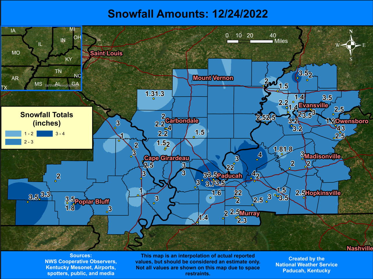
Snow amounts were relatively light, peaking at around 4 inches. Drifts from strong winds made measuring difficult but here is a map of the best observations/measurements from the storm. This was the first December measurable snow in some towns across our area since 2014, including Paducah.
Extreme Cold
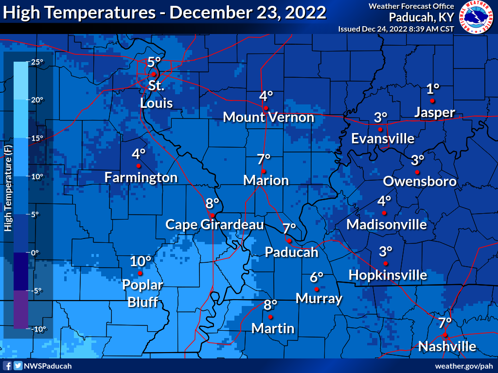
The extreme cold was the headliner of the event. High temperatures were in the single digits almost everywhere.
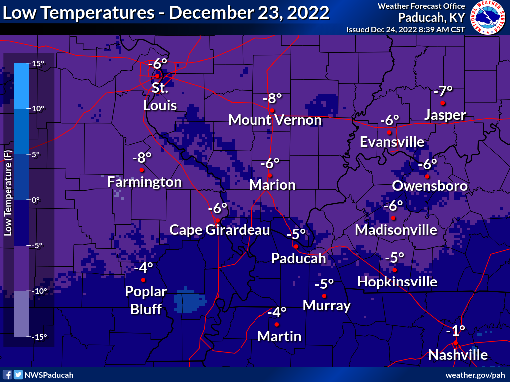
Overnight lows fell from 4 to 10 degrees below zero.
The cold temperatures and 25-35 mph winds dropped wind chills to extreme levels. Minimum wind chills ranged from 20 to 33 degrees below zero.​ 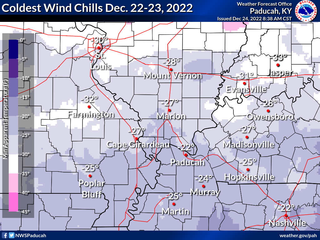
Photos
 |
 |
 |
 |
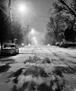
| Low Visibility and Ice Covered Streets Nancy Boyett, Henderson, KY |
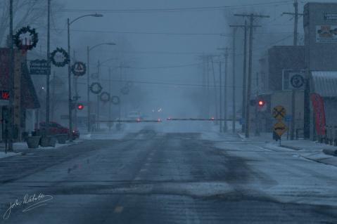
Frosty Streets in Johnston City John Diebolt, Johnston City, IL |
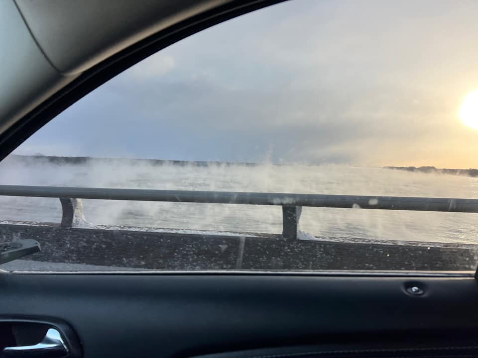
Relatively warm river water condenses under the cold wind Chris Taylor, Metropolis, IL |
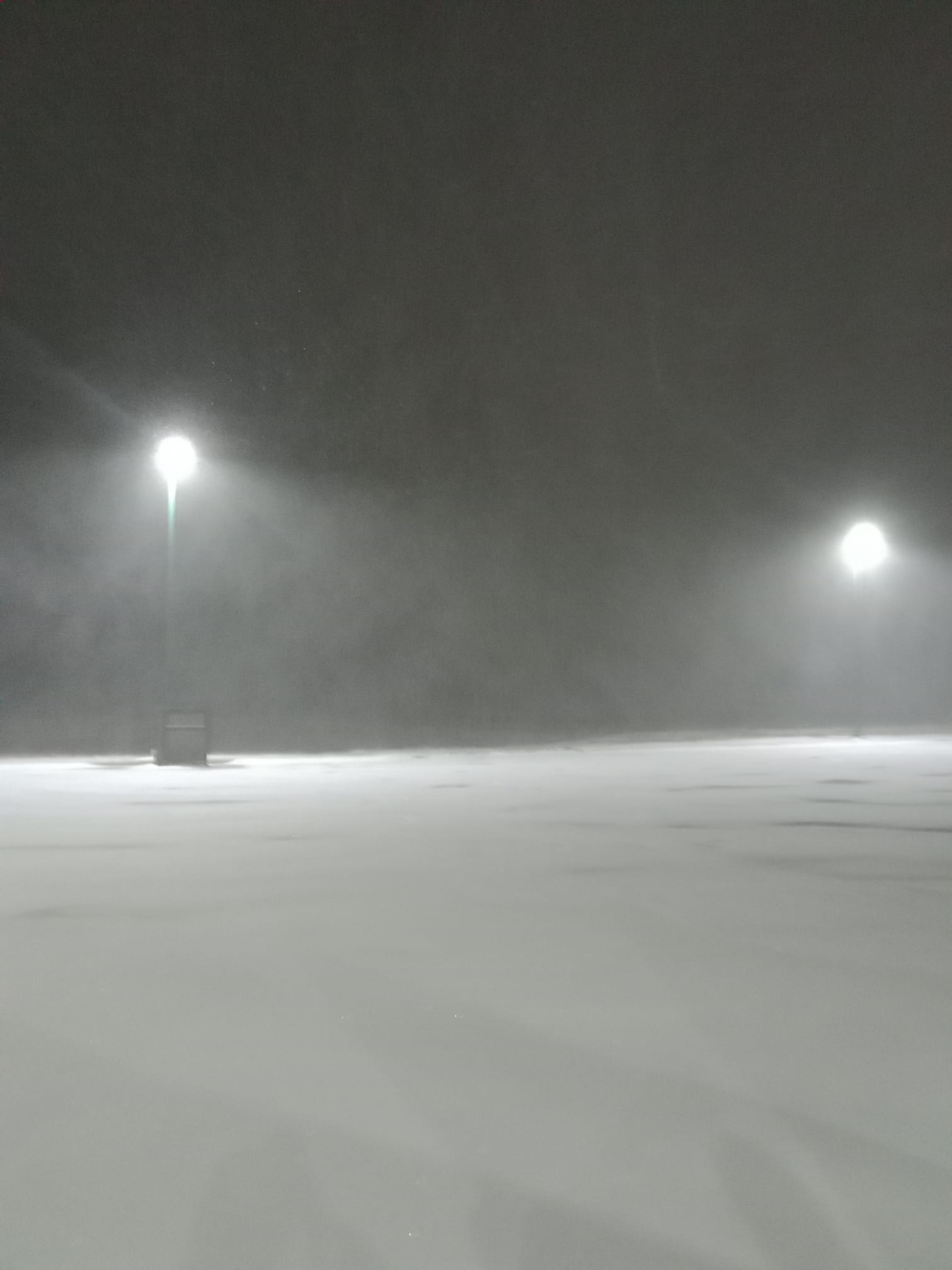
Visibility drops to around 1/4 mile in heavy blowing snow Aaron Cathart, Paducah, KY |
Storm Reports
Public Information Statement
National Weather Service Paducah KY
329 AM CST Fri Dec 23 2022

...SNOWFALL REPORTS...

Location                     Amount    Time/Date       Lat/Lon
2 E Owensboro                4.0 in    1109 PM 12/22   37.76N/87.09W
Marion                       4.0 in    1006 PM 12/22   37.33N/88.08W
Marion                       4.0 in    1020 PM 12/22   37.33N/88.08W
Carbondale                   4.0 in    0925 PM 12/22   37.72N/89.22W
1 E Poplar Bluff             3.5 in    0755 PM 12/22   36.77N/90.39W
1 NNE Paducah                3.5 in    0828 PM 12/22   37.08N/88.63W
1 SE Paducah                 3.5 in    0954 PM 12/22   37.06N/88.62W
Newburgh                     3.5 in    0955 PM 12/22   37.95N/87.40W
Boonville                    3.5 in    1145 PM 12/22   38.05N/87.27W
Princeton                    3.5 in    0200 AM 12/23   38.36N/87.57W
Grandin                      3.3 in    0445 PM 12/22   36.83N/90.82W
Bernie                       3.0 in    1045 PM 12/22   36.67N/89.97W
Perryville                   3.0 in    1100 PM 12/22   37.73N/89.87W
East Prairie                 3.0 in    0950 PM 12/22   36.78N/89.38W
Canton                       3.0 in    0949 PM 12/22   36.80N/87.96W
2 SE Heath                   3.0 in    0950 PM 12/22   37.07N/88.77W
2 SE Heath                   3.0 in    1200 AM 12/23   37.07N/88.77W
7 W Salem                    3.0 in    1000 PM 12/22   37.28N/88.37W
Madisonville                 3.0 in    0942 PM 12/22   37.34N/87.51W
2 NW Lovelaceville           3.0 in    0934 PM 12/22   36.98N/88.86W
Dudley                       2.5 in    0820 PM 12/22   36.80N/90.09W
2 E Cape Girardeau           2.5 in    0823 PM 12/22   37.31N/89.52W
1 SSE Aurora                 2.5 in    1200 AM 12/23   36.76N/88.14W
Hopkinsville                 2.5 in    1115 PM 12/22   36.85N/87.49W
Murray                       2.5 in    0925 PM 12/22   36.61N/88.32W
Murray                       2.5 in    1025 PM 12/22   36.61N/88.32W
3 E Mill Spring              2.0 in    1050 PM 12/22   37.06N/90.62W
Fruitland                    2.0 in    0840 PM 12/22   37.45N/89.64W
Benton                       2.0 in    0954 PM 12/22   36.85N/88.36W
4 NNE Dawson Springs         2.0 in    1000 PM 12/22   37.22N/87.67W
Mortons Gap                  2.0 in    1200 AM 12/23   37.24N/87.47W
Henderson                    2.0 in    0942 PM 12/22   37.84N/87.58W
Murray                       2.0 in    0827 PM 12/22   36.61N/88.32W
Herrin                       2.0 in    1000 AM 12/22   37.80N/89.03W
Anna                         2.0 in    1225 AM 12/23   37.46N/89.24W
De Soto                      2.0 in    0900 PM 12/22   37.81N/89.22W
Grayville                    2.0 in    0953 PM 12/22   38.26N/88.00W
Hopkinsville                 1.5 in    0939 PM 12/22   36.85N/87.49W
1 S Boonville                1.5 in    0938 PM 12/22   38.03N/87.27W
Sikeston                     1.0 in    0941 PM 12/22   36.88N/89.58W
Friedheim                    1.0 in    1000 PM 12/22   37.57N/89.82W

Observations are collected from a variety of sources with varying
equipment and exposures. We thank all volunteer weather observers
for their dedication. Not all data listed are considered official.
Public Information Statement
National Weather Service Paducah KY
502 AM CST Fri Dec 23 2022

...12 HOUR MINIMUM WIND CHILL REPORTS AT 5 AM 12/23/2022...

Location                     WC Temp.   Lat/Lon
Harrisburg IL                -33 F      37.82N/88.55W
Fairfield                    -32 F      38.38N/88.39W
0.9 W De Soto (UPR)          -32 F      37.82N/89.24W
3.0 E Griffin (INDOT)        -31 F      38.20N/87.86W
Mt Vernon IL                 -31 F      38.32N/88.87W
Perryville MO                -31 F      37.87N/89.87W
Rend Lake                    -30 F      38.14N/88.92W
Henderson KY                 -30 F      37.82N/87.67W
Owensboro KY                 -30 F      37.72N/87.17W
3.6 SE Grand Tower (UPR)     -30 F      37.60N/89.46W
Greenville KY 6 N            -29 F      37.29N/87.16W
Henderson                    -29 F      37.79N/87.51W
Morganfield KY 4 E           -29 F      37.69N/87.84W
Henderson KY 5 E             -29 F      37.82N/87.51W
Carbondale                   -29 F      37.70N/89.24W
1.2 NE Melody Hill (INDOT)   -29 F      38.06N/87.48W
Princeton KY 2 SE            -29 F      37.10N/87.86W
Calhoun KY 5 NW              -29 F      37.59N/87.32W
Marion KY 4 NE               -29 F      37.38N/88.04W
3.6 N Benton (UPR)           -29 F      38.06N/88.90W
Carmi IL                     -28 F      38.08N/88.12W
Carbondale IL                -28 F      37.78N/89.25W
Hopkinsville KY 6 N          -28 F      36.95N/87.52W
3.7 SE Owensboro             -27 F      37.72N/87.08W
Bardwell                     -27 F      36.84N/88.92W
Dixon Springs                -27 F      37.44N/88.67W
Evansville IN                -27 F      38.05N/87.52W
Murray KY 1 W                -27 F      36.61N/88.34W
Mayfield KY 6 SW             -27 F      36.70N/88.72W
Elkton KY 5 SW               -27 F      36.76N/87.21W
Cadiz KY 4 SW                -26 F      36.83N/87.86W
Herrin                       -26 F      37.79N/89.01W
Madisonville KY 4 S          -26 F      37.27N/87.48W
Madisonville KY              -26 F      37.35N/87.40W
Cape Girardeau MO            -26 F      37.23N/89.58W
Marion IL                    -26 F      37.77N/89.02W
Sturgis Municipal Airport    -26 F      37.54N/87.95W
Benton KY 4 N                -25 F      36.92N/88.34W
Henderson                    -25 F      37.77N/87.48W
Bardwell                     -25 F      36.87N/88.89W
Philpot                      -25 F      37.70N/86.93W
Hickman KY 2 E               -25 F      36.57N/89.16W
Murray KY                    -25 F      36.67N/88.37W
Greenville KY                -25 F      37.22N/87.15W
Metropolis IL                -25 F      37.18N/88.75W
Poplar Bluff MO              -25 F      36.77N/90.32W
Charleston, MO South         -25 F      36.85N/89.36W
1.4 W Ash Hill (UPR)         -25 F      36.77N/90.26W
6.5 S Delta (UPR)            -25 F      37.11N/89.77W
Crab Orchard IL              -24 F      37.68N/89.00W
Carbondale                   -24 F      37.71N/89.20W
Greenville KY                -24 F      37.22N/87.15W
2.9 N Bonnie (UPR)           -24 F      38.24N/88.90W
Dixon Springs IL             -23 F      37.44N/88.67W
Cairo IL                     -23 F      37.07N/89.22W
Fort Campbell KY             -23 F      36.67N/87.50W
Paducah KY                   -23 F      37.07N/88.77W
Sikeston MO                  -22 F      36.90N/89.57W
Doniphan MO                  -21 F      36.65N/90.78W
Haubstadt                    -21 F      38.20N/87.52W
Golden Pond KY               -21 F      36.78N/88.06W
Piedmont MO                  -21 F      37.24N/90.27W
1.6 E Dexter MO(SCAN)        -20 F      36.78N/89.93W
Dahlgren                     -20 F      38.17N/88.60W


Observations are collected from a variety of sources with varying
equipment and exposures. We thank all volunteer weather observers
for their dedication. Not all data listed are considered official.
 |
Media use of NWS Web News Stories is encouraged! Please acknowledge the NWS as the source of any news information accessed from this site. |
|

