Overview
|
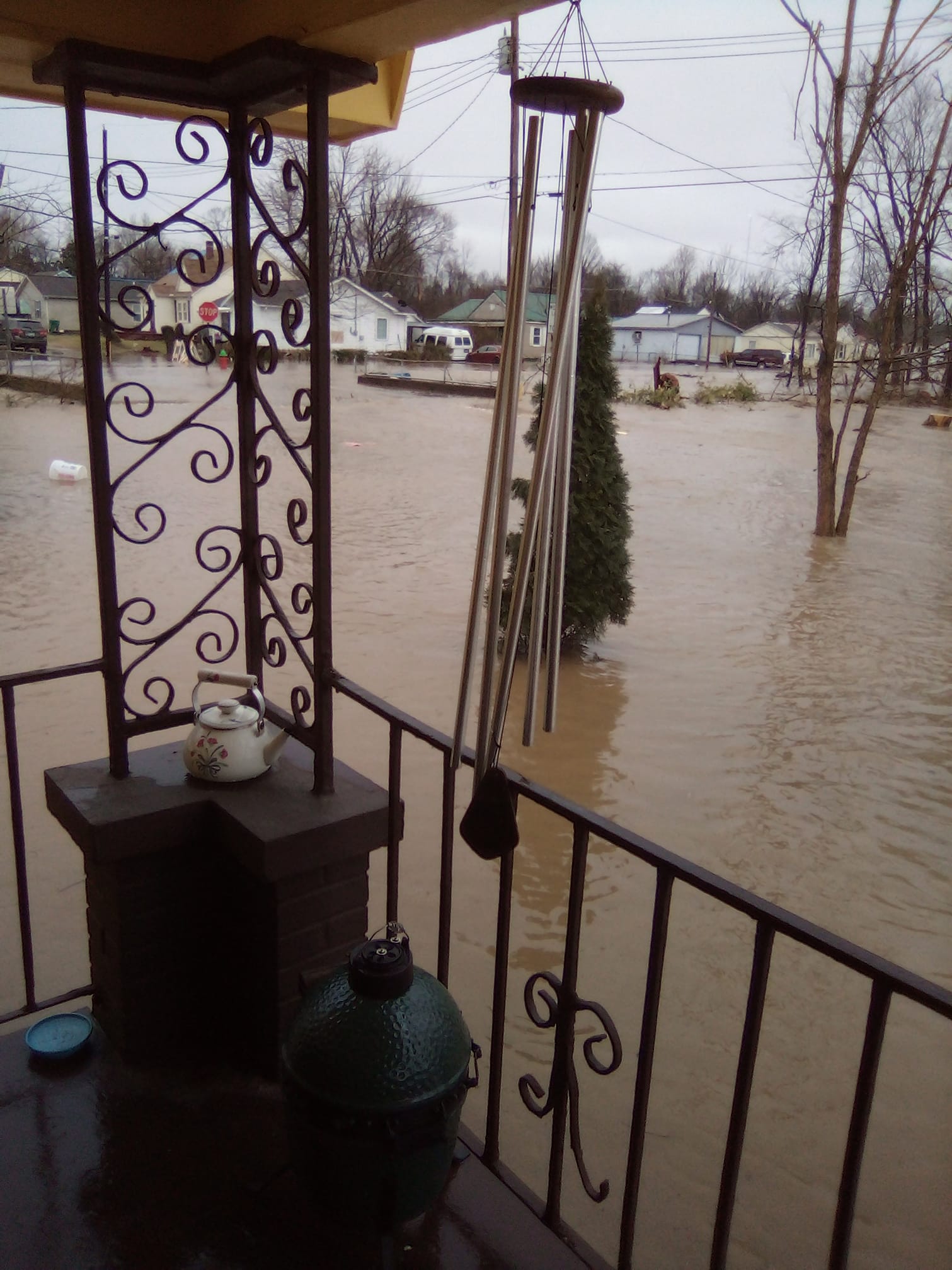
On February 17, 2022, several rounds of heavy rain and thunderstorms moved across the region. Rainfall of 2 to 5 inches fell in just a few hours, creating widespread flooding issues. Some of the worst flooding occurred in western Kentucky, particularly in the Mayfield area, where some homes and apartment complexes were surrounded by floodwaters. |
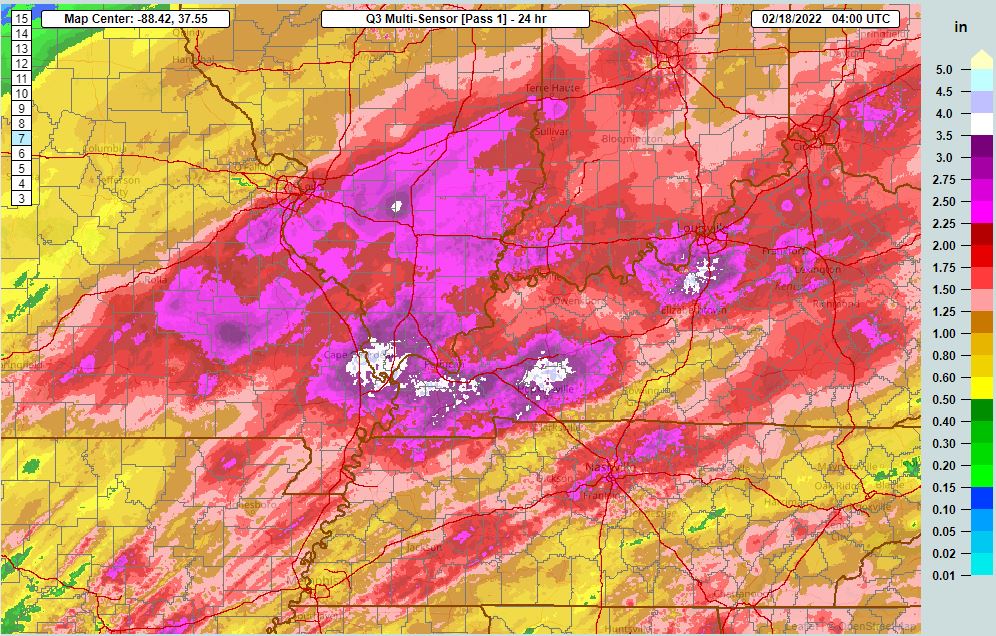 Estimated storm total rainfall accumulation. Click to enlarge the photo. Link to the source of this image via NSSL MRMS. |
Photos & Video
Click on a photo to enlarge it.
 |
 |
 |
 |
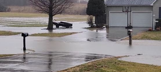
| Garden Apartments in Mayfield, KY (Noah Bergren/WPSD-TV) |
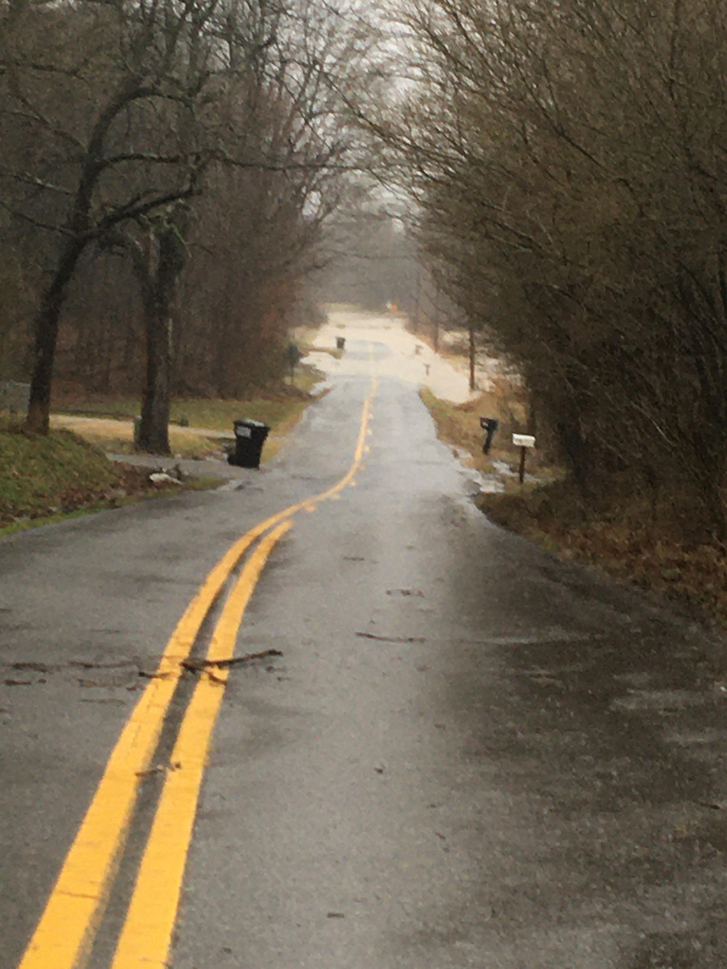
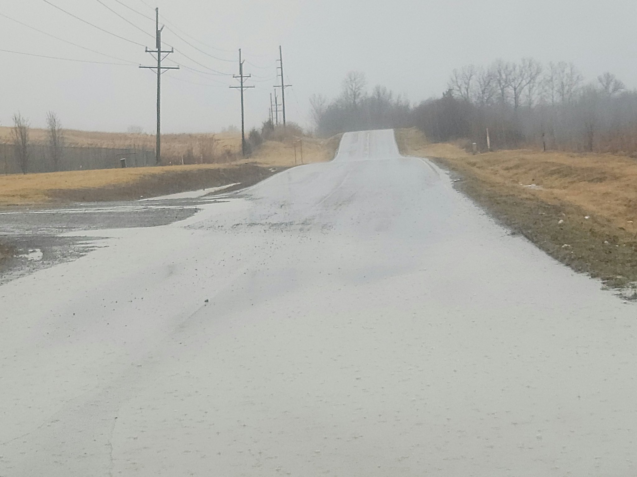
Metropolis Lake Road in West Paducah, KY (Beau Dodson) |
Lone Oak, KY (Sean Poulos) |
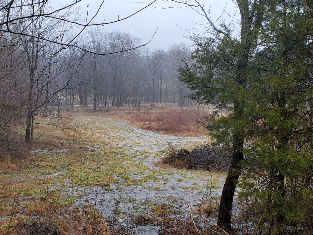
Field flooding in Cobden, IL (Leo Driscoll) |
 |
 |
 |
| Intersection of College and Wilford in Mayfield, KY (Juanita May) |
Bandyville Road in Marion, IL (JJ Diebolt) |
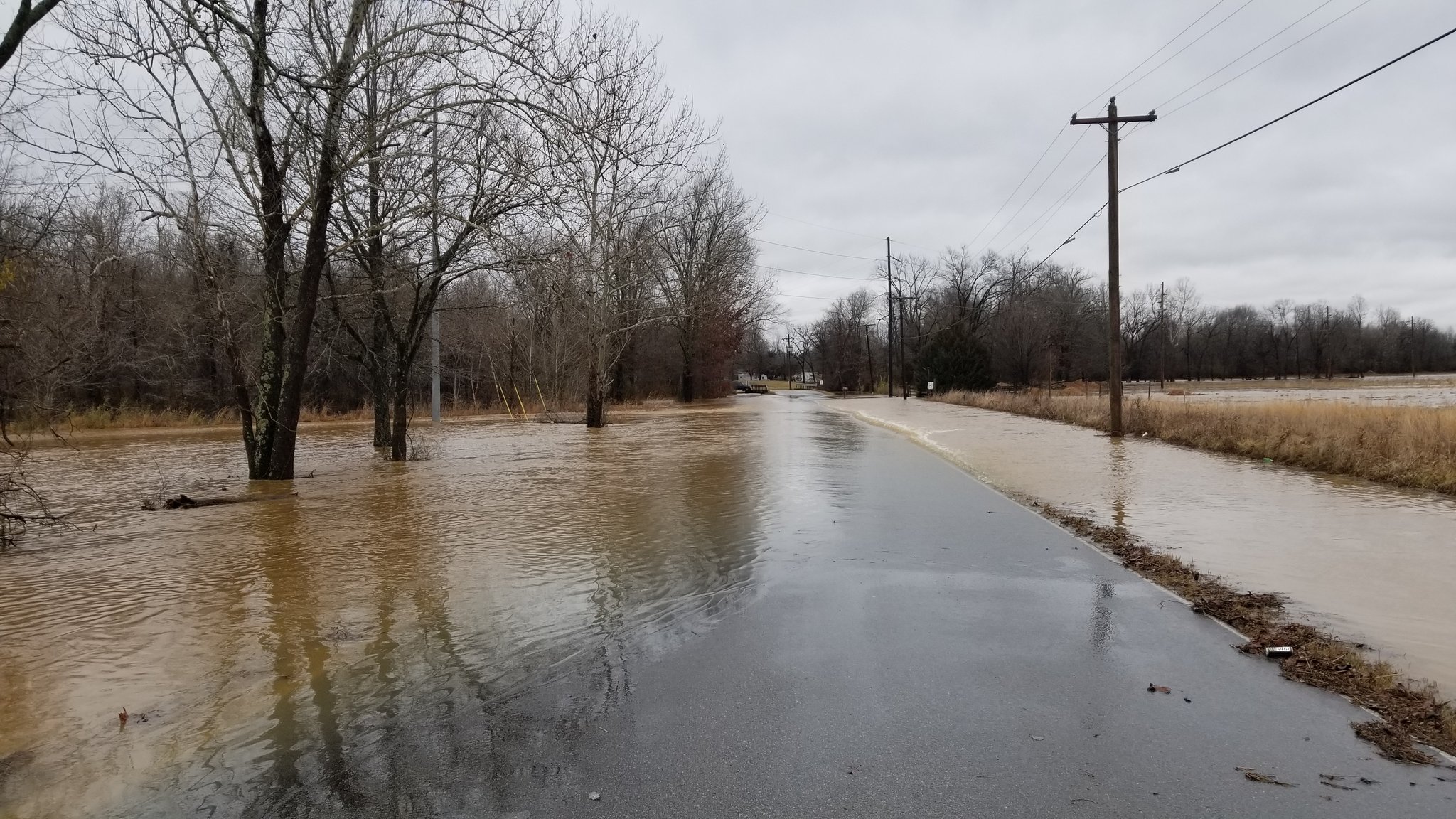
Roxie Road in Poplar Bluff, MO (Jeremy Stephens) |
Radar
Click on the link below to be taken to a radar loop of this flooding event.
Link to a composite radar loop of this event via the Iowa State Mesonet Archive.
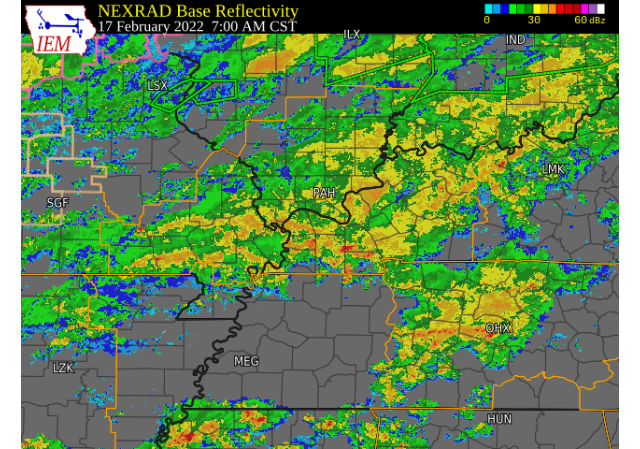 |
| Composite radar image via the Iowa State Mesonet taken at 7 AM CST Thursday, February, 17, 2022. Click to enlarge the image. |
Storm Reports
PRELIMINARY LOCAL STORM REPORT...SUMMARY
NATIONAL WEATHER SERVICE PADUCAH KY
1028 PM CST THU FEB 17 2022

..TIME...   ...EVENT...      ...CITY LOCATION...     ...LAT.LON...
..DATE...   ....MAG....      ..COUNTY LOCATION..ST.. ...SOURCE....
            ..REMARKS..

1032 PM     NON-TSTM WND GST 3 SSW DE SOTO           37.78N 89.25W
02/16/2022  M44 MPH          JACKSON            IL   ASOS

            ASOS STATION KMDH CARBONDALE IL.

1220 AM     NON-TSTM WND GST 4 NE MARION             37.38N 88.04W
02/17/2022  M43 MPH          CRITTENDEN         KY   MESONET

            MESONET STATION RPTN MARION KY 4 NE.

0127 AM     NON-TSTM WND GST 5 W ASH HILL            36.77N 90.32W
02/17/2022  M43 MPH          BUTLER             MO   ASOS

            ASOS STATION KPOF POPLAR BLUFF MO.

0200 AM     NON-TSTM WND GST 2 SE HEATH              37.07N 88.77W
02/17/2022  M40 MPH          MCCRACKEN          KY   ASOS

            ASOS STATION KPAH PADUCAH KY.

0205 AM     NON-TSTM WND GST 4 NNE WINGO             36.70N 88.72W
02/17/2022  M41 MPH          GRAVES             KY   MESONET

            MESONET STATION PRYB MAYFIELD KY 6 SW.

0215 AM     NON-TSTM WND GST 2 WNW FORT CAMPBELL NOR 36.67N 87.50W
02/17/2022  M40 MPH          CHRISTIAN          KY   AWOS

            AWOS STATION KHOP FORT CAMPBELL KY.

0230 AM     NON-TSTM WND GST 4 SW CADIZ              36.83N 87.86W
02/17/2022  M46 MPH          TRIGG              KY   MESONET

            MESONET STATION CADZ CADIZ KY 4 SW.

0235 AM     NON-TSTM WND GST 4 NE TRENTON            36.76N 87.21W
02/17/2022  M41 MPH          TODD               KY   MESONET

            MESONET STATION ZION ELKTON KY 5 SW.

0235 AM     NON-TSTM WND GST 4 NW CALHOUN            37.59N 87.32W
02/17/2022  M41 MPH          MCLEAN             KY   MESONET

            MESONET STATION PVRT CALHOUN KY 5 NW.

0245 AM     NON-TSTM WND GST 7 NNW HOPKINSVILLE      36.95N 87.52W
02/17/2022  M41 MPH          CHRISTIAN          KY   MESONET

            MESONET STATION PGHL HOPKINSVILLE KY 6 N.

0255 AM     NON-TSTM WND GST 3 ESE KIRKSEY           36.67N 88.37W
02/17/2022  M40 MPH          CALLOWAY           KY   AWOS

            AWOS STATION KCEY MURRAY KY.

0305 AM     NON-TSTM WND GST 4 NNW MURRAY            36.67N 88.33W
02/17/2022  M41 MPH          CALLOWAY           KY   MESONET

            MESONET STATION AP881 MURRAY KY.

0310 AM     NON-TSTM WND GST 2 WSW CENTRAL CITY      37.29N 87.16W
02/17/2022  M43 MPH          MUHLENBERG         KY   MESONET

            MESONET STATION CCTY GREENVILLE KY 6 N.

0657 AM     HEAVY RAIN       5 ENE THEBES            37.25N 89.38W
02/17/2022  M1.57 INCH       ALEXANDER          IL   MESONET

            MESONET STATION BNRI2 BEAN RIDGE IL.

0700 AM     HEAVY RAIN       1 WSW WAPPAPELLO        36.93N 90.28W
02/17/2022  M1.60 INCH       WAYNE              MO   CO-OP OBSERVER

            CO-OP OBSERVER STATION WPPM7 WAPPAPELLO MO
            0.8 W.

0700 AM     HEAVY RAIN       2 WNW PERRYVILLE        37.73N 89.92W
02/17/2022  M1.95 INCH       PERRY              MO   CO-OP OBSERVER

            CO-OP OBSERVER STATION PRRM7 PERRYVILLE MO
            WATER PLANT.

0700 AM     HEAVY RAIN       3 WNW MILLERSVILLE      37.45N 89.85W
02/17/2022  M1.61 INCH       CAPE GIRARDEAU     MO   COCORAHS

            COCORAHS STATION MO-CG-18 MILLERSVILLE 3.2
            WNW.

0700 AM     HEAVY RAIN       1 SW JACKSON            37.37N 89.67W
02/17/2022  M2.24 INCH       CAPE GIRARDEAU     MO   COCORAHS

            COCORAHS STATION MO-FSA-031 JACKSON MO 1 SW.

0706 AM     HEAVY RAIN       COBDEN                  37.53N 89.25W
02/17/2022  M1.79 INCH       UNION              IL   TRAINED SPOTTER


0726 AM     HEAVY RAIN       1 SSE SCOTT CITY        37.21N 89.53W
02/17/2022  M2.43 INCH       SCOTT              MO   MESONET

            MESONET STATION FW2859 SCOTT CITY.

0730 AM     HEAVY RAIN       10 E FRUITLAND          37.45N 89.46W
02/17/2022  M1.87 INCH       CAPE GIRARDEAU     MO   MESONET

            MESONET STATION MOCM7 3.4 W WARE.

0857 AM     FLOOD            3 NNW MELBER            36.99N 88.75W
02/17/2022                   MCCRACKEN          KY   DEPT OF HIGHWAYS

            KYDOT REPORTED FLOODING ON KY 1438 IN
            SOUTHERN MCCRACKEN COUNTY NEAR NEW HOPE
            CHURCH.

0857 AM     FLOOD            1 WSW LONE OAK          37.03N 88.68W
02/17/2022                   MCCRACKEN          KY   PUBLIC

            CREEK FLOWING INTO YARD. VIA SOCIAL MEDIA.

0857 AM     FLOOD            4 S GILBERTSVILLE       36.96N 88.30W
02/17/2022                   MARSHALL           KY   DEPT OF HIGHWAYS

            REPORTED BY KYDOT - FLOODING ON U.S. 641 IN
            MARSHALL COUNTY BETWEEN KY DAM VILLAGE STATE
            PARK AND DRAFFENVILLE.

0900 AM     HEAVY RAIN       2 SSW LONE OAK          37.02N 88.68W
02/17/2022  M2.39 INCH       MCCRACKEN          KY   NWS EMPLOYEE

            THROUGH 845 AM.

0930 AM     FLOOD            2 ESE LONE OAK          37.02N 88.63W
02/17/2022                   MCCRACKEN          KY   DEPT OF HIGHWAYS

            MULTIPLE SECONDARY ROADS ARE EXPERIENCING
            SOME FLOODING. KY 1327/LOVELACEVILLE RD AT
            5.5 TO 6.5MM KY 339/CLINTON RD AT 6.2 TO
            6.4MM KY 994/OLD MAYFIELD RD AT 5.5 TO 5.7MM
            KY 1014/HOUSER RD AT 3.2 TO 3.7MM KY
            1565/MAYFIELD-METROPOLIS RD AT 4.5 TO 5.5MM
            BETWEEN U.S. 60 AND KY 305 KY 1438/NEW HOPE
            CHURCH RD AT 3MM NEAR NEW HOPE CHURCH.

0954 AM     HEAVY RAIN       2 SSW LONE OAK          37.01N 88.68W
02/17/2022  M3.03 INCH       MCCRACKEN          KY   NWS EMPLOYEE

            0.64 IN THE LAST HOUR.

1000 AM     HEAVY RAIN       WALTONVILLE             38.21N 89.04W
02/17/2022  E2.30 INCH       JEFFERSON          IL   PUBLIC

            RELAYED VIA MEDIA.

1032 AM     HEAVY RAIN       2 NE DARMSTADT          38.11N 87.55W
02/17/2022  E2.00 INCH       VANDERBURGH        IN   PUBLIC


1033 AM     FLOOD            PADUCAH                 37.07N 88.63W
02/17/2022                   MCCRACKEN          KY   DEPT OF HIGHWAYS

            JACKSON STREET CLOSED AT THE RAILROAD
            OVERPASS.

1100 AM     FLOOD            3 SE HEATH              37.06N 88.74W
02/17/2022                   MCCRACKEN          KY   TRAINED SPOTTER

            WATER OVER OLD HINKLEVILLE ROAD.

1146 AM     FLOOD            2 NE ENERGY             37.79N 89.00W
02/17/2022                   WILLIAMSON         IL   TRAINED SPOTTER

            SEVERAL LOCATIONS OF BANDYVILLE RD AND NEAR
            CLARK TRAIL RD UNDER WATER.

1147 AM     HEAVY RAIN       2 SSE HEATH             37.07N 88.77W
02/17/2022  M2.42 INCH       MCCRACKEN          KY   OFFICIAL NWS OBS

            RAINFALL IN THE PAST 6 HOURS AT WFO PADUCAH.

1201 PM     HEAVY RAIN       1 SE GRAND RIVERS       37.00N 88.23W
02/17/2022  M2.01 INCH       LIVINGSTON         KY   TRAINED SPOTTER


1205 PM     FLOOD            2 WSW LONE OAK          37.02N 88.70W
02/17/2022                   MCCRACKEN          KY   BROADCAST MEDIA

            MASSAC CREEK OVERFLOWING INTO NEARBY FIELDS.

1246 PM     HEAVY RAIN       1 SW SPILLERTOWN        37.75N 88.93W
02/17/2022  M2.28 INCH       WILLIAMSON         IL   PUBLIC


0112 PM     HEAVY RAIN       KUTTAWA                 37.06N 88.10W
02/17/2022  E4.06 INCH       LYON               KY   COCORAHS

            3.24 IN THE LAST 6 HOURS.

0132 PM     HEAVY RAIN       DIEHLSTADT              36.96N 89.43W
02/17/2022  M3.31 INCH       SCOTT              MO   TRAINED SPOTTER

            MINOR FLOODING OF ROADS.

0146 PM     FLASH FLOOD      3 S MARION              37.69N 88.94W
02/17/2022                   WILLIAMSON         IL   PUBLIC

            FLASH FLOODING OVER THE ROAD VEHICLE NEARLY
            STALLED.

0154 PM     FLASH FLOOD      4 NNW NEW COLUMBIA      37.36N 88.79W
02/17/2022                   JOHNSON            IL   PUBLIC

            CREEKS FLOODING WITH WATER OVER THE ROAD.

0201 PM     HEAVY RAIN       2 SW LONE OAK           37.02N 88.68W
02/17/2022  M4.79 INCH       MCCRACKEN          KY   COCORAHS

            TOTAL AMOUNT OF RAIN REPORTED SINCE IT
            STARTED RAINING TODAY.

0205 PM     FLASH FLOOD      1 W POPLAR BLUFF        36.76N 90.42W
02/17/2022                   BUTLER             MO   TRAINED SPOTTER

            ROADS FLOODED.

0216 PM     FLASH FLOOD      2 S PRINCETON           38.33N 87.57W
02/17/2022                   GIBSON             IN   PUBLIC

            ROADS FLOODED IN THE AREA.

0219 PM     FLASH FLOOD      1 NNE MAYFIELD          36.75N 88.64W
02/17/2022                   GRAVES             KY   PUBLIC

            ROADS FLOODED , WITH DEBRIS FLOATING.

0226 PM     FLOOD            3 ESE MELODY HILL       38.01N 87.46W
02/17/2022                   VANDERBURGH        IN   PUBLIC

            2.10 INCHES OF RAIN REPORTED , ROADS FLOODED
            IN THE AREA.

0240 PM     HEAVY RAIN       CALVERT CITY            37.03N 88.35W
02/17/2022  M4.15 INCH       MARSHALL           KY   PUBLIC

            RAIN HAS STOPPED.

0240 PM     HEAVY RAIN       COBDEN                  37.53N 89.25W
02/17/2022  M4.02 INCH       UNION              IL   PUBLIC

            TOTAL RAINFALL TODAY.

0253 PM     HEAVY RAIN       PRINCETON               37.11N 87.88W
02/17/2022  M3.64 INCH       CALDWELL           KY   TRAINED SPOTTER

            TOTAL RAINFALL FOR TODAY.

0253 PM     HEAVY RAIN       1 WNW ROUND KNOB        37.26N 88.76W
02/17/2022  M3.30 INCH       MASSAC             IL   COCORAHS

            TOTAL RAINFALL SINCE 5AM.
Rain Reports
PUBLIC INFORMATION STATEMENT
NATIONAL WEATHER SERVICE PADUCAH KY
1135 PM CST THU FEB 17 2022

...RAINFALL REPORTS THROUGH 11 PM THURSDAY, FEBRUARY 17TH...

LOCATION                     AMOUNT    TIME/DATE       PROVIDER

...ILLINOIS...

...ALEXANDER COUNTY...
BEAN RIDGE                   4.05 IN   0957 PM 02/17   RAWS
0.9 SE COMMERCE              3.35 IN   1030 PM 02/17   HADS
0.9 NW THEBES                3.25 IN   1030 PM 02/17   HADS
CAIRO                        3.06 IN   1035 PM 02/17   AWOS
0.8 E CAIRO                  1.23 IN   1000 PM 02/17   COOP

...EDWARDS COUNTY...
ALBION                       2.54 IN   0215 PM 02/17   CWOP

...FRANKLIN COUNTY...
WEST FRANKFORT               2.50 IN   1040 PM 02/17   CWOP
ROYALTON                     2.34 IN   1035 PM 02/17   CWOP
3 N WEST CITY                2.11 IN   1030 PM 02/17   HADS
2 NNW ZEIGLER                1.95 IN   1045 PM 02/17   AWS
2.0 E ZEIGLER                1.80 IN   1030 PM 02/17   COOP

...GALLATIN COUNTY...
6 S JUNCTION                 2.48 IN   1045 PM 02/17   AWS

...HARDIN COUNTY...
1 NE ELIZABETHTOWN           2.29 IN   1045 PM 02/17   AWS

...JACKSON COUNTY...
MAKANDA 2.5 N                2.94 IN   0315 PM 02/17   COCORAHS
0.8 SE MURPHYSBORO           1.87 IN   1030 PM 02/17   HADS
1 E CARBONDALE               1.81 IN   1044 PM 02/17   AWS
CARBONDALE                   1.75 IN   0952 PM 02/17   ASOS
GRAND TOWER                  1.72 IN   1030 PM 02/17   HADS
MURPHYSBORO                  1.24 IN   1045 PM 02/17   AWS

...JEFFERSON COUNTY...
SCHELLER                     3.16 IN   1039 PM 02/17   CWOP
WALTONVILLE                  2.76 IN   0200 PM 02/17   COOP
3.1 SE WOODLAWN              1.95 IN   1030 PM 02/17   HADS
ASHLEY                       1.89 IN   0515 PM 02/17   CWOP
DIX                          1.71 IN   1030 PM 02/17   CWOP
2.8 N WALTONVILLE            1.69 IN   1030 PM 02/17   HADS

...MASSAC COUNTY...
1 WSW ROUND KNOB             3.30 IN   0253 PM 02/17   COCORAHS
METROPOLIS                   2.60 IN   1035 PM 02/17   AWOS

...PERRY COUNTY...
PINCKNEYVILLE                2.15 IN   1044 PM 02/17   AWS
DU QUOIN                     1.67 IN   1045 PM 02/17   AWS

...POPE COUNTY...
DIXON SPRINGS                3.31 IN   1008 PM 02/17   RAWS
SHAWNEE PORTABLE NO. 1       2.90 IN   0954 PM 02/17   RAWS
1 W GOLCONDA                 2.17 IN   1045 PM 02/17   AWS

...SALINE COUNTY...
HARRISBURG                   2.45 IN   1035 PM 02/17   AWOS

...UNION COUNTY...
COBDEN                       4.02 IN   0240 PM 02/17   TRAINED SPOTTER

...WABASH COUNTY...
MOUNT CARMEL IL              1.71 IN   1045 PM 02/17   AWS

...WAYNE COUNTY...
1 N WAYNE CITY               2.54 IN   1000 PM 02/17   HADS
FAIRFIELD                    2.21 IN   1035 PM 02/17   AWOS

...WHITE COUNTY...
1 N CARMI                    2.44 IN   1030 PM 02/17   HADS

...WILLIAMSON COUNTY...
CRAB ORCHARD                 3.41 IN   0955 PM 02/17   RAWS
CRAINVILLE                   2.75 IN   1035 PM 02/17   CWOP
CARTERVILLE                  2.70 IN   0618 PM 02/17   BROADCAST MEDIA
MARION                       2.68 IN   1045 PM 02/17   AWS
5 SW MARION                  2.36 IN   0955 PM 02/17   HADS
1 SSW SPILLERTOWN            2.28 IN   1246 PM 02/17

...INDIANA...

...GIBSON COUNTY...
OAKLAND CITY                 2.05 IN   1037 PM 02/17   CWOP
1.6 SE MOUNT CARMEL          0.72 IN   0945 PM 02/17   COOP
0.5 W HAZLETON               0.69 IN   0945 PM 02/17   HADS

...POSEY COUNTY...
MOUNT VERNON                 2.73 IN   1030 PM 02/17   CWOP
2 N MOUNT VERNON             2.38 IN   1045 PM 02/17   AWS
WADESVILLE                   2.22 IN   1034 PM 02/17   CWOP
7 E MOUNT VERNON             1.98 IN   1045 PM 02/17   AWS
8 W EVANSVILLE               1.25 IN   1110 AM 02/17   COCORAHS

...VANDERBURGH COUNTY...
EVANSVILLE 4 W               3.45 IN   0821 PM 02/17   TRAINED SPOTTER
EVANSVILLE 2.5 NE            2.43 IN   0500 PM 02/17   COCORAHS
EVANSVILLE IN                2.25 IN   0954 PM 02/17   ASOS
EVANSVILLE IN MUSEUM         2.22 IN   0430 PM 02/17   COOP
2 NE DARMSTADT               2.00 IN   1032 AM 02/17


...WARRICK COUNTY...
NEWBURGH                     1.87 IN   1036 PM 02/17   CWOP
1.4 N NEWBURGH               0.95 IN   1000 PM 02/17   COOP

...KENTUCKY...

...BALLARD COUNTY...
GAGE                         4.03 IN   1038 PM 02/17   CWOP
WICKLIFFE                    3.17 IN   1035 PM 02/17   CWOP
1.4 E OLMSTED                3.03 IN   1000 PM 02/17   UCOOP

...CALDWELL COUNTY...
PRINCETON                    3.64 IN   0253 PM 02/17   TRAINED SPOTTER
4.3 W CERULEAN               2.67 IN   1030 PM 02/17   HADS

...CALLOWAY COUNTY...
1.6 SE MURRAY                3.14 IN   1000 PM 02/17   HADS
MURRAY 1 W                   2.37 IN   1045 PM 02/17   KYMN2
5 SSE AURORA                 2.28 IN   1040 PM 02/17   AWS
NEW CONCORD KY               2.07 IN   1030 PM 02/17   CWOP

...CHRISTIAN COUNTY...
HOPKINSVILLE 6 N             2.82 IN   1045 PM 02/17   KYMN2
HOPKINSVILLE                 2.50 IN   0425 PM 02/17   TRAINED SPOTTER
1.8 NE HOPKINSVILLE          2.67 IN   1030 PM 02/17   HADS
1.2 SE HOPKINSVILLE          2.16 IN   1030 PM 02/17   HADS
3.4 E HOPKINSVILLE           1.88 IN   1030 PM 02/17   HADS
FORT CAMPBELL                1.83 IN   1031 PM 02/17   AWOS
HERNDON                      1.52 IN   1030 PM 02/17   CWOP
5.2 N PEMBROKE               1.46 IN   1030 PM 02/17   HADS

...CRITTENDEN COUNTY...
MARION 4 NE                  2.63 IN   1045 PM 02/17   KYMN2

...DAVIESS COUNTY...
LEWISPORT                    2.25 IN   1039 PM 02/17   CWOP
2 W OWENSBORO                2.15 IN   0340 PM 02/17   TRAINED SPOTTER
OWENSBORO                    1.99 IN   0956 PM 02/17   AWOS
WHITESVILLE                  1.67 IN   1045 PM 02/17   AWS
2 E OWENSBORO                1.40 IN   1044 PM 02/17   AWS

...FULTON COUNTY...
HICKMAN KY 2 E               2.11 IN   1045 PM 02/17   KYMN2
FULTON 5 W                   1.41 IN   0937 PM 02/17   TRAINED SPOTTER

...GRAVES COUNTY...
MAYFIELD                     3.32 IN   0410 PM 02/17   PUBLIC
MAYFIELD                     3.12 IN   1035 PM 02/17   CWOP
MAYFIELD 6 SW                3.02 IN   1045 PM 02/17   KYMN2

...HENDERSON COUNTY...
HENDERSON 5 E                1.80 IN   1045 PM 02/17   KYMN2
HENDERSON                    1.53 IN   0956 PM 02/17   AWOS
0.7 NW HENDERSON             1.36 IN   0945 PM 02/17   HADS

...HOPKINS COUNTY...
MADISONVILLE 4 S             3.26 IN   1045 PM 02/17   KYMN2
MADISONVILLE                 2.42 IN   1035 PM 02/17   AWOS

...LIVINGSTON COUNTY...
1.9 W GRAND RIVERS           2.49 IN   1030 PM 02/17   COOP

...LYON COUNTY...
EDDYVILLE                    4.10 IN   0544 PM 02/17   TRAINED SPOTTER
1.5 NE GRAND RIVERS          3.34 IN   1030 PM 02/17   HADS

...MARSHALL COUNTY...
CALVERT CITY                 4.15 IN   0240 PM 02/17   BROADCAST MEDIA
BENTON 4 N                   3.50 IN   1040 PM 02/17   KYMN2
3 W FAIRDEALING              2.94 IN   1030 PM 02/17   HADS

...MCCRACKEN COUNTY...
PADUCAH 4.5 SW               4.79 IN   0147 PM 02/17   NWS EMPLOYEE
WEST PADUCAH                 3.40 IN   1036 PM 02/17   CWOP
PADUCAH 0.9 NNE              3.52 IN   0530 PM 02/17   NWS EMPLOYEE
PADUCAH                      3.14 IN   0953 PM 02/17   ASOS
1.6 W METROPOLIS             2.81 IN   1000 PM 02/17   COOP

...MCLEAN COUNTY...
LIVERMORE                    2.80 IN   1000 PM 02/17   HADS
0.6 SW CALHOUN               2.75 IN   1000 PM 02/17   HADS
CALHOUN 5 NW                 2.39 IN   1045 PM 02/17   KYMN2

...MUHLENBERG COUNTY...
CENTRAL CITY                 2.90 IN   1035 PM 02/17   CWOP
GREENVILLE 6 N               2.90 IN   1045 PM 02/17   KYMN2
GREENVILLE                   2.64 IN   0955 PM 02/17   RAWS
3.2 NW POWDERLY              1.34 IN   0955 PM 02/17   HADS

...TODD COUNTY...
ELKTON                       2.54 IN   1030 PM 02/17   CWOP
3 SE ALLEGRE                 2.54 IN   1040 PM 02/17   AWS
1.9 S ELKTON                 1.51 IN   1030 PM 02/17   HADS
ELKTON 5 SW                  1.22 IN   1045 PM 02/17   KYMN2

...TRIGG COUNTY...
GOLDEN POND                  2.20 IN   1021 PM 02/17   RAWS
CADIZ 4 SW                   2.16 IN   1045 PM 02/17   KYMN2
CANTON                       1.70 IN   1000 PM 02/17   HADS
7.7 SW GRACEY                1.04 IN   1000 PM 02/17   HADS

...UNION COUNTY...
MORGANFIELD 4 E              1.93 IN   1040 PM 02/17   KYMN2
2.7 W UNIONTOWN              1.30 IN   1000 PM 02/17   HADS

...MISSOURI...

...BUTLER COUNTY...
4 W ASH HILL                 3.23 IN   0953 PM 02/17   ASOS
POPLAR BLUFF                 2.68 IN   0703 PM 02/17   EMERGENCY MANAGER

...CAPE GIRARDEAU COUNTY...
CAPE GIRARDEAU 1 ESE         3.80 IN   0204 PM 02/17   COCORAHS
3.4 W WARE                   3.49 IN   1030 PM 02/17   HADS
1.5 S DUTCHTOWN              3.43 IN   1000 PM 02/17   HADS
1.8 E CAPE GIRARDEAU         2.97 IN   1030 PM 02/17   HADS

...CARTER COUNTY...
CHICOPEE                     1.98 IN   1022 PM 02/17   RAWS
0.6 NW CHICOPEE              1.75 IN   1030 PM 02/17   HADS

...MISSISSIPPI COUNTY...
4.9 S CACHE                  3.20 IN   1030 PM 02/17   HADS
2 SE CAIRO                   2.99 IN   1030 PM 02/17   HADS
CHARLESTON SOUTH             2.88 IN   1045 PM 02/17   MOCOMAGNET

...PERRY COUNTY...
3 NE FARRAR                  2.29 IN   1030 PM 02/17   HADS
PERRYVILLE                   2.11 IN   1015 PM 02/17   AWOS

...RIPLEY COUNTY...
DONIPHAN                     1.92 IN   0953 PM 02/17   RAWS

...SCOTT COUNTY...
SCOTT CITY                   5.65 IN   1040 PM 02/17   CWOP
CAPE GIRARDEAU               3.63 IN   0953 PM 02/17   ASOS
DIEHLSTADT                   3.31 IN   0132 PM 02/17   TRAINED SPOTTER
6.3 NE DIEHLSTADT            2.94 IN   1030 PM 02/17   HADS
1.1 W MINER                  2.44 IN   1000 PM 02/17   HADS

...STODDARD COUNTY...
FISK                         1.67 IN   1000 PM 02/17   HADS

...WAYNE COUNTY...
PIEDMONT                     3.20 IN   1030 PM 02/17   RAWS
2.6 E PATTERSON              2.43 IN   1030 PM 02/17   HADS
0.7 W GREENVILLE             1.98 IN   1030 PM 02/17   HADS
WAPPAPELLO 0.8 W             1.96 IN   1030 PM 02/17   COOP

OBSERVATIONS ARE COLLECTED FROM A VARIETY OF SOURCES WITH VARYING
EQUIPMENT AND EXPOSURES. WE THANK ALL VOLUNTEER WEATHER OBSERVERS
FOR THEIR DEDICATION. NOT ALL DATA LISTED ARE CONSIDERED OFFICIAL.
 |
Media use of NWS Web News Stories is encouraged! Please acknowledge the NWS as the source of any news information accessed from this site. |
|

