Overview
During the early morning hours of Tuesday, February 22, 2022, a line of severe thunderstorms moved through southeast Missouri and western Kentucky. The line of storms produce a microburst with peak winds of 90 mph near Neelyville, MO, in southeast Butler County. Near Cayce, KY, in Fulton County, an EF-0 tornado occurred. Additional scattered wind damage was reported in Bernie, MO, in Stoddard County and in Conran, MO, in New Madrid County.Tornado:
|
Tornado - 3 miles SW of Cayce, KY
|
||||||||||||||||
The Enhanced Fujita (EF) Scale classifies tornadoes into the following categories:
| EF0 Weak 65-85 mph |
EF1 Moderate 86-110 mph |
EF2 Significant 111-135 mph |
EF3 Severe 136-165 mph |
EF4 Extreme 166-200 mph |
EF5 Catastrophic 200+ mph |
 |
|||||
Wind:
The line of severe thunderstorms produced a microburst that caused damage southeast of Neelyville, MO, in Butler County.
|
Microburst - 5 miles ESE of Neelyville, MO
|
||||||||||||||
Photos
Click on a photo to enlarge.
 |
 |
 |
 |
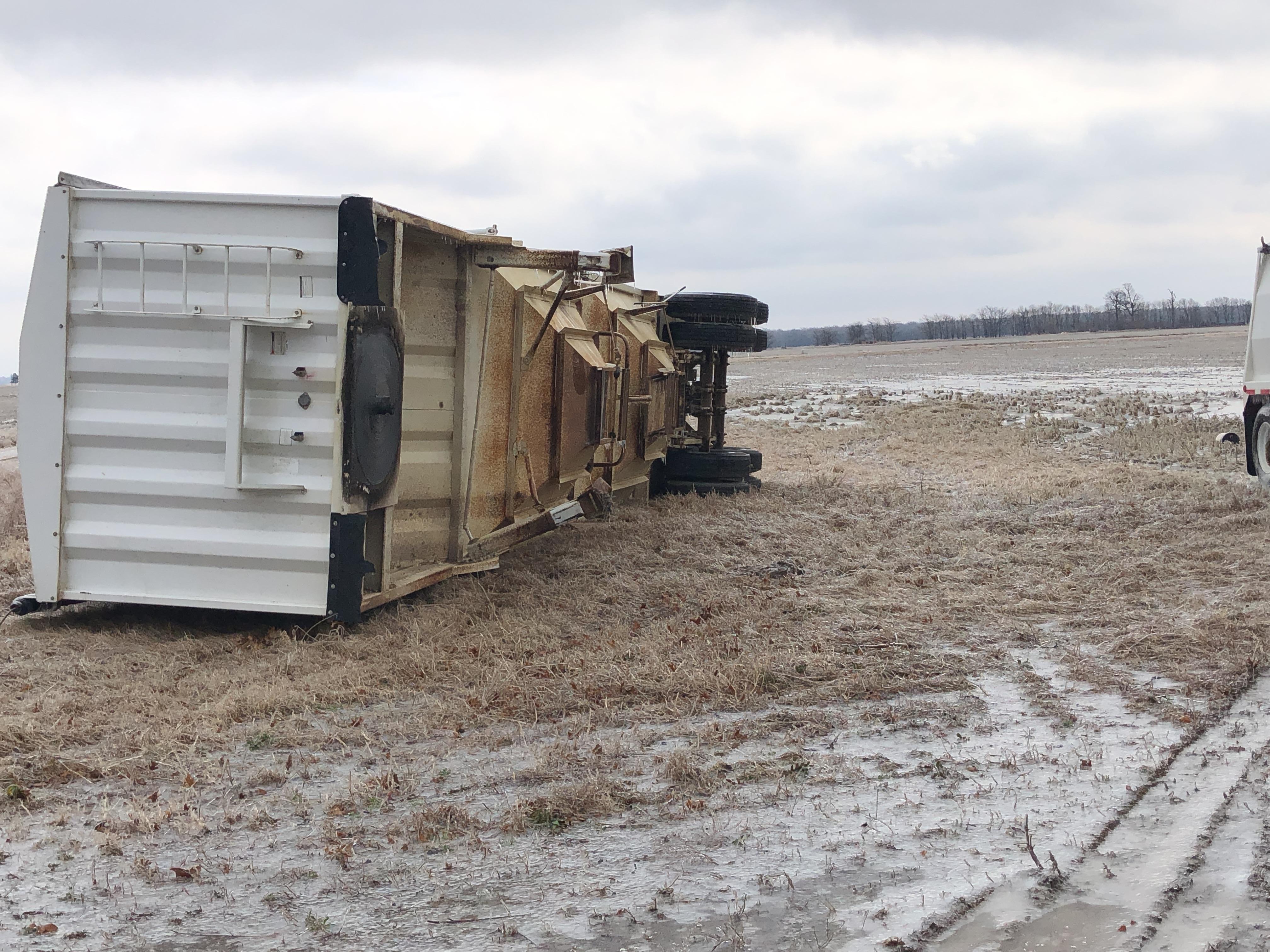
| Semi truck flipped onto its side near Neelyville, MO (NWS Damage Survey) |
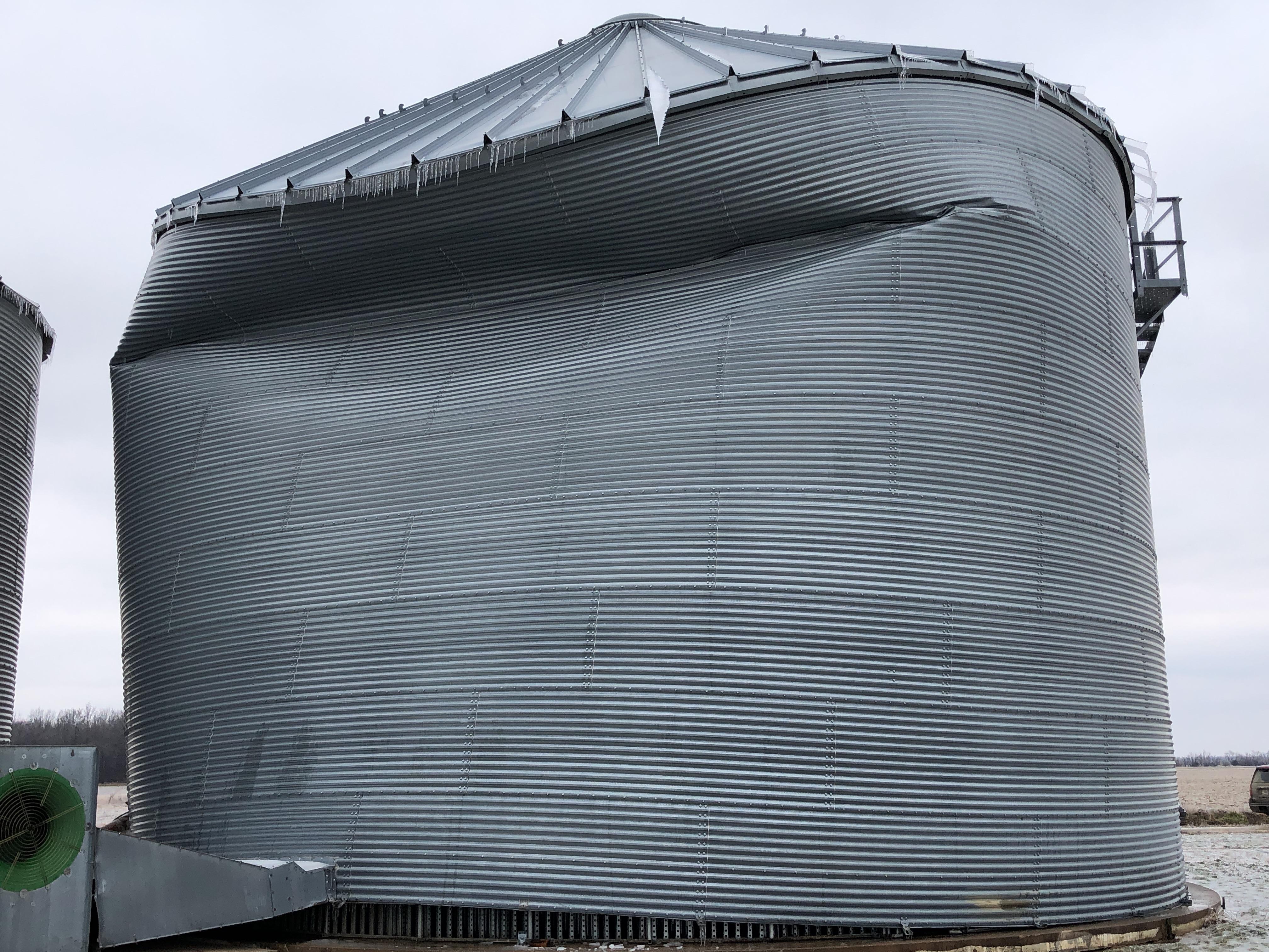
Damage to a grain silo near Neelyville, MO (NWS Damage Survey) |
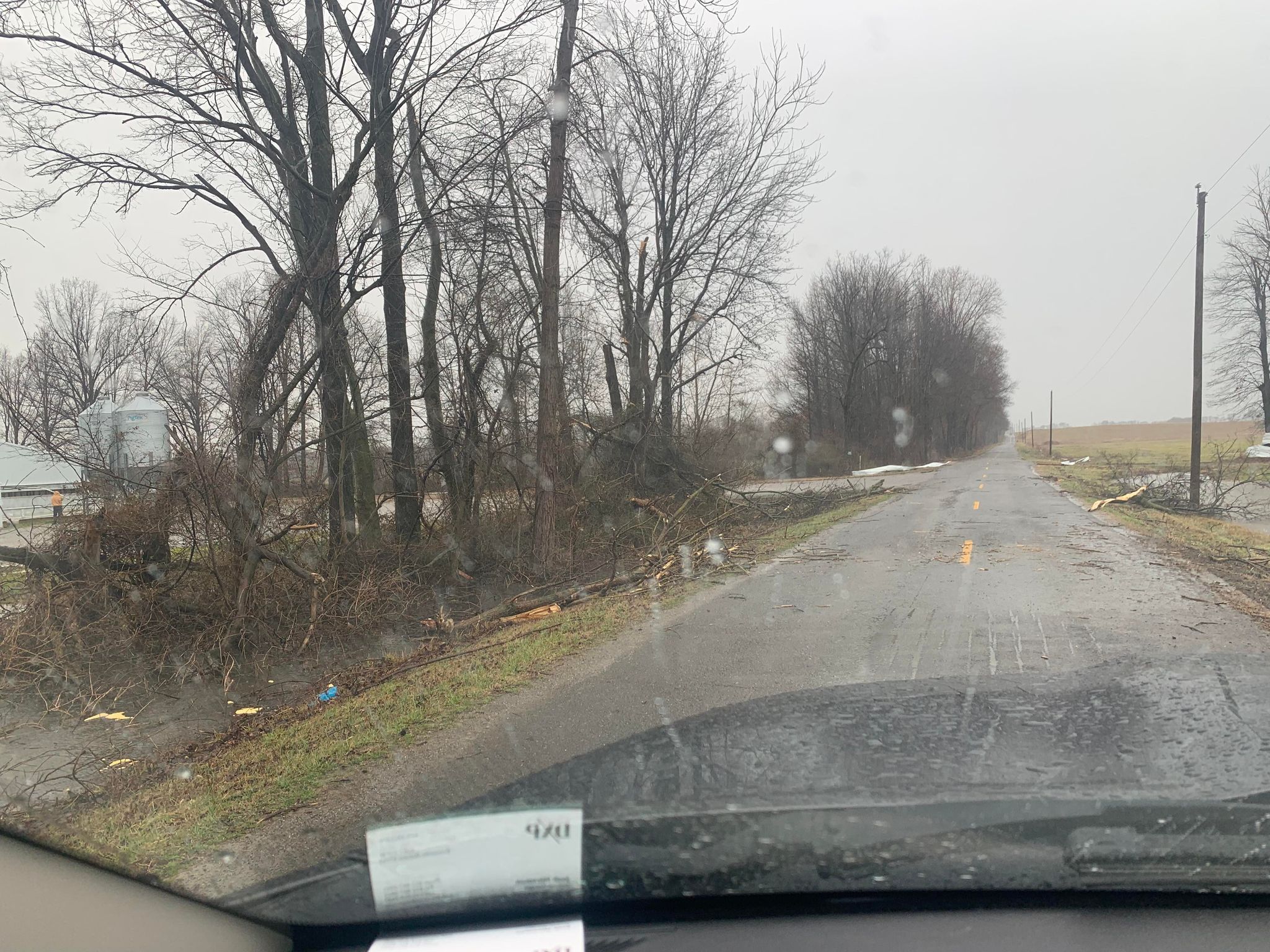
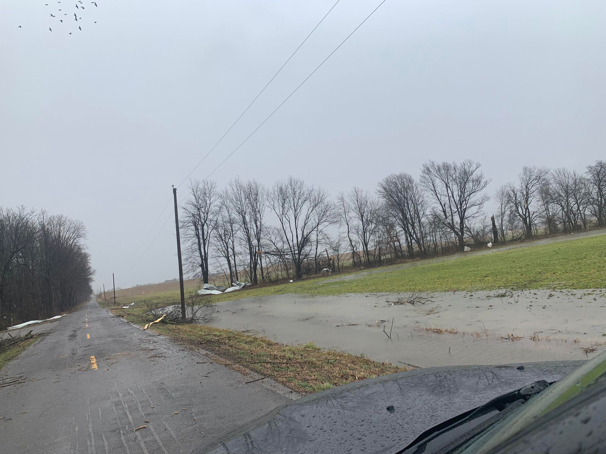
Tree damage near Cayce, KY (Josh Stirsman and Noah Bergren/WPSD) |
Storm damage near Cayce, KY (Josh Stirsman and Noah Bergren/WPSD) |
Radar
Click on an image to enlarge. Click here for a composite radar loop of this event from the Iowa State Mesonet.
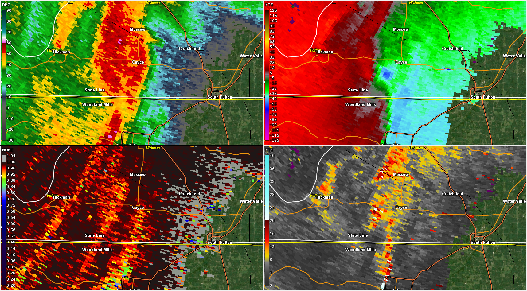 |
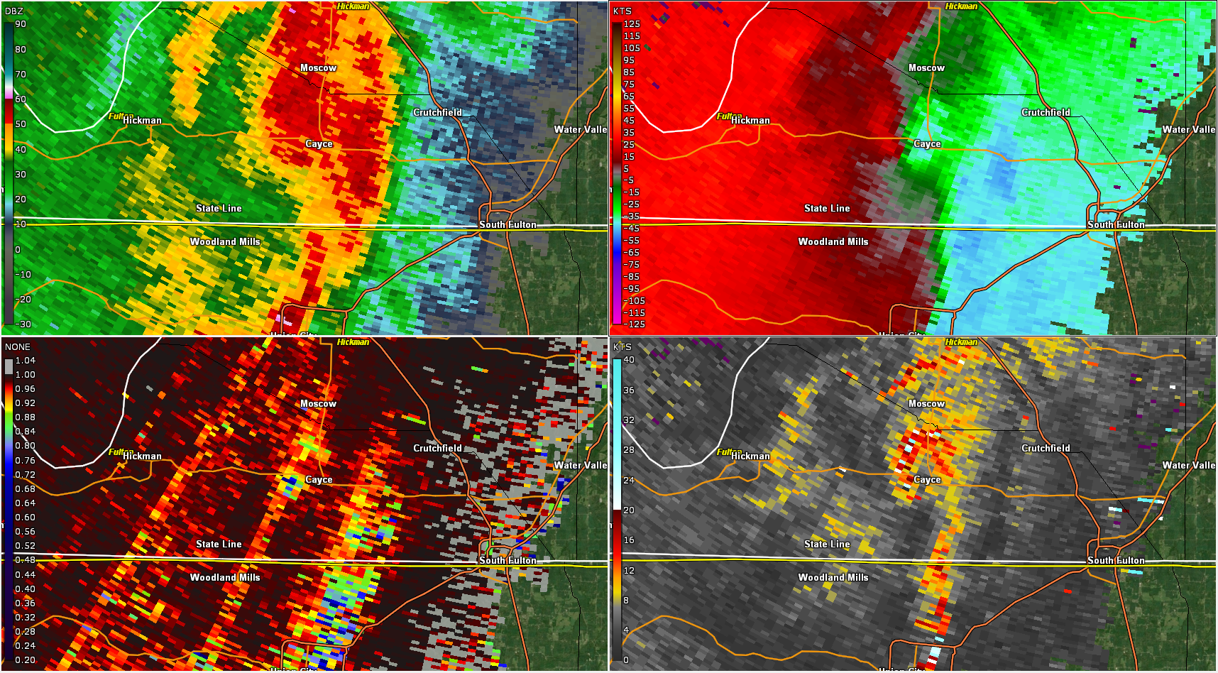 |
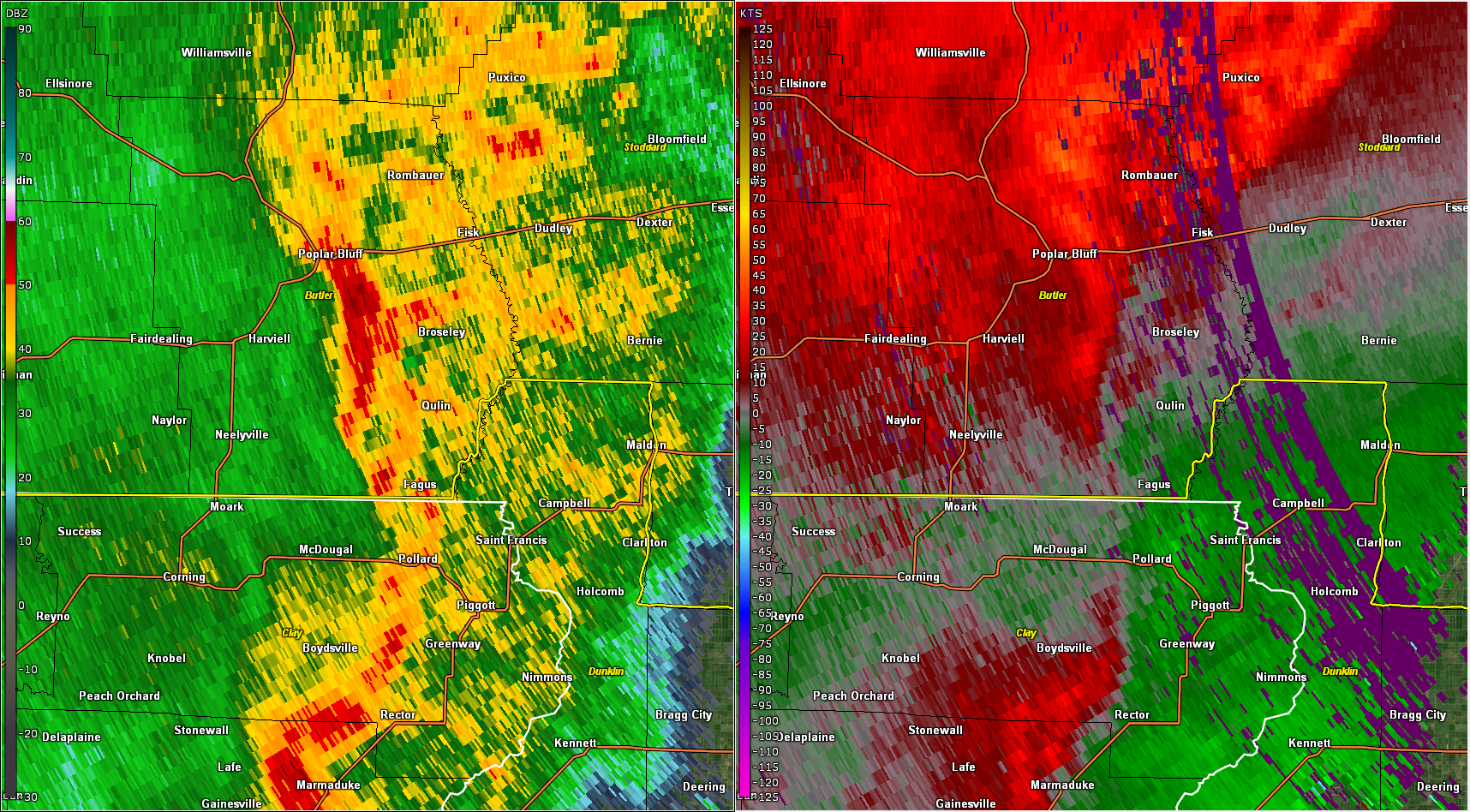 |
| KPAH WSR-88D 0.5° tilt base reflectivity/storm relative velocity/correlation coefficient/spectrum width at 6:28 AM CST near Cayce, KY. | KPAH WSR-88D 0.5° tilt base reflectivity/storm relative velocity/correlation coefficient/spectrum width at 6:31 AM CST near Cayce, KY. | KPAH WSR-88D 0.9° tilt base reflectivity and storm relative velocity near Neelyville, MO. |
Storm Reports
PRELIMINARY LOCAL STORM REPORT...SUMMARY
NATIONAL WEATHER SERVICE PADUCAH KY
657 PM CST FRI FEB 25 2022
..TIME... ...EVENT... ...CITY LOCATION... ...LAT.LON...
..DATE... ....MAG.... ..COUNTY LOCATION..ST.. ...SOURCE....
..REMARKS..
0512 AM DOWNBURST 5 ESE NEELYVILLE 36.53N 90.42W
02/22/2022 BUTLER MO NWS STORM SURVEY
AN NWS STORM DAMAGE SURVEY FOUND A
MICROBURST WITH WINDS OF 80 TO 90 MPH STRUCK
SOUTHEAST BUTLER COUNTY EARLY TUESDAY
MORNING BETWEEN 512 AND 518 AM CST. THE
MICROBURST BEGAN ABOUT 5 MILES ESE OF
NEELYVILLE, JUST NORTH OF ALLRED LAKE
NATURAL AREA ALONG COUNTY ROAD 2601 AND
ENDED ALONG COUNTY ROAD 214 IN COON ISLAND
CONSERVATION AREA, ABOUT 5.2 MILES WSW OF
QULIN. THE PATH LENGTH WAS 6.5 MILES, AND
THE SWATH OF THE WIND DAMAGE WAS
APPROXIMATELY 1000 YARDS WIDE. ONE SEMI
TRAILER WAS FLIPPED ONTO ITS SIDE, AND AN
EMPTY GRAIN BIN WAS ALSO TURNED ONTO ITS
SIDE. THREE WOODEN ELECTRICAL POLES WERE
PUSHED NEARLY TO THE GROUND. A GRAIN SILO
WAS SEVERELY DENTED. A MOBILE HOME WAS
SHIFTED OFF ITS FOUNDATION WITH A SMALL
PORTION OF ITS ROOF DECKING REMOVED. SEVERAL
OUTBUILDINGS WERE SEVERELY DAMAGED OR
DESTROYED. ONE BRICK HOME SUFFERED WIND
DAMAGE TO SEVERAL WINDOWSILLS. A HANDFUL OF
TREES WERE UPROOTED, AND SEVERAL LARGE TREE
BRANCHES WERE ALSO BROKEN.
0530 AM TSTM WND DMG 2 W BERNIE 36.67N 90.01W
02/22/2022 STODDARD MO EMERGENCY MNGR
8-10 INCH DIAMETER TREE, 20 FEET LONG,
FALLEN ONTO HWY U.
0554 AM TSTM WND DMG CONRAN 36.48N 89.65W
02/22/2022 NEW MADRID MO NWS STORM SURVEY
A FEW OUTBUILDINGS HAD SHINGLES REMOVED FROM
THEIR ROOFS. LARGE BARNS SUFFERED ROOF
DAMAGE. MINOR SIDING AND ROOF DAMAGE TO A
FEW HOMES. A FEW LARGE TREE LIMBS DOWNED.
0555 AM TSTM WND DMG CONRAN 36.49N 89.65W
02/22/2022 NEW MADRID MO EMERGENCY MNGR
SMALL PORTION OF LARGE METAL BUILDING
COLLAPSED WITH MANY OF THE ROOF METAL SHEETS
BLOWN OFF. SEVERAL HOUSES/BUILDINGS WITH
SOME SHINGLES BLOWN OFF. MINOR TREE DAMAGE
WITH A FEW TREES UPROOTED. IRRIGATION PIPES
BLOWN AROUND.
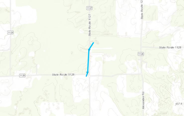
0628 AM TORNADO 3 SW CAYCE 36.53N 89.08W
02/22/2022 FULTON KY NWS STORM SURVEY
THE TORNADO TOUCHED DOWN SOUTH OF 1128. IT
MOVED NORTH ALONG 1127 AND DISSIPATED IN A
FIELD JUST EAST OF 1127. DAMAGED HOG BARNS
AND SOME TREES. MAX WINDS - 75 MPH LENGTH -
.7 MILES MAX WIDTH - 100 YARDS.
0631 AM TSTM WND DMG CAYCE 36.56N 89.05W
02/22/2022 FULTON KY NWS STORM SURVEY
ONE BARN DESTROYED, OTHERS DAMAGED. WINDS
ESTIMATED AT 70 MPH.
0632 AM TSTM WND DMG 2 NW CRUTCHFIELD 36.60N 88.96W
02/22/2022 HICKMAN KY NWS STORM SURVEY
BARNS AND SHEDS DAMAGED. WINDS EST. 70 MPH.
 |
Media use of NWS Web News Stories is encouraged! Please acknowledge the NWS as the source of any news information accessed from this site. |
|