Overview
|
On February 23 and 24, 2022, waves of sleet and freezing rain moved through the region. The wintry precipitation produced hazardous driving conditions across much of the area. Isolated power outages occurred due to tree damage from freezing rain accretion. The greatest accretions of freezing rain occurred across southeast Missouri into southwest Illinois, where 0.1 to 0.4 inches of icing was reported. Sleet accumulations of 0.1 to 0.75 inches were observed across much of the region, though an isolated higher amount up to 1.25 inches was was reported in Carter County, Missouri. On February 24, many of the freezing rain and sleet showers across southeast Missouri into southern Illinois were accompanied by numerous lightning strikes and rolls of thunder. A thunderstorm in Hopkins County, KY, produced pea sized hail as well. Two pileups occurred on major highways in western Kentucky. Both occurred on bridges. One of the pileups was on Interstate 24 over the Tennessee River bridge, where one fatality was reported. The other pileup was on the Western Kentucky Parkway over the Green River bridge. Both involved multiple semis. |
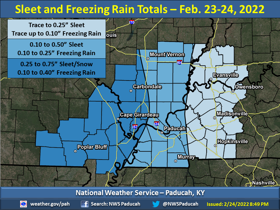 Estimated Sleet and Freezing Rain Accumulation Map (click to enlarge) |
Photos & Video
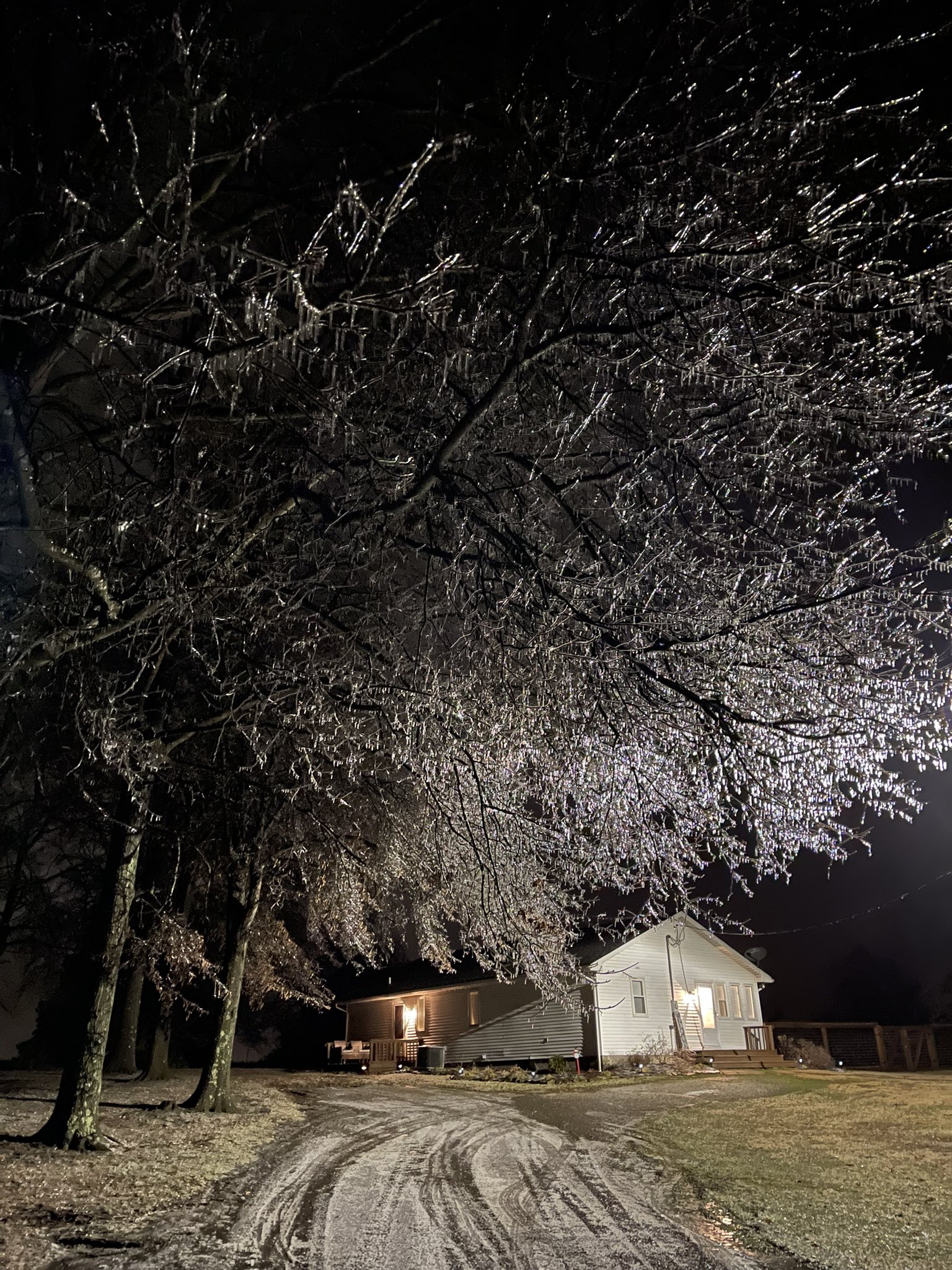
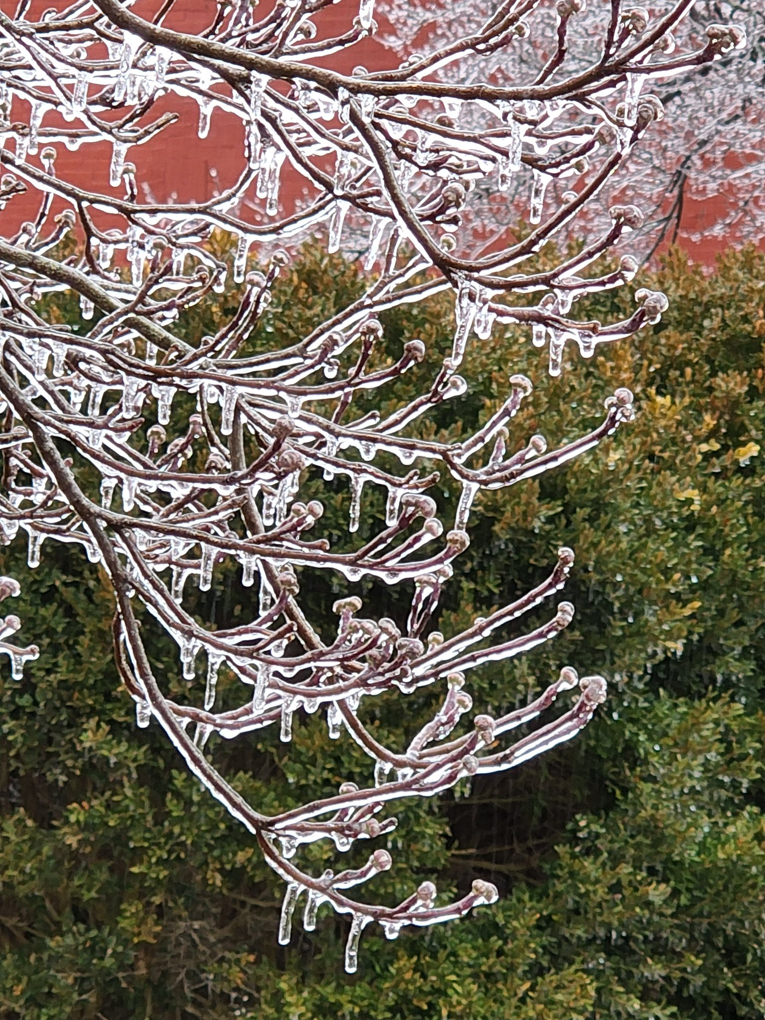
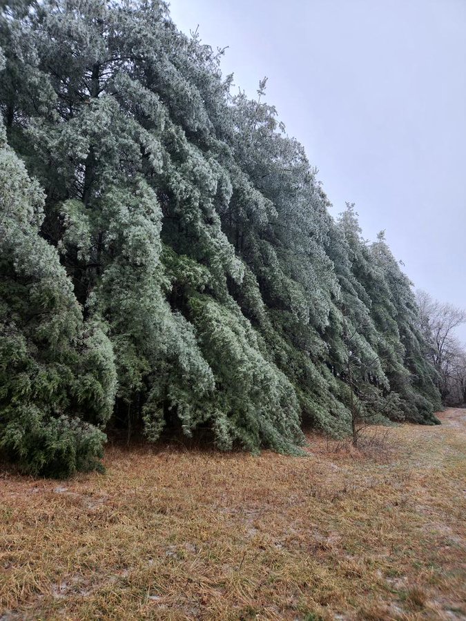
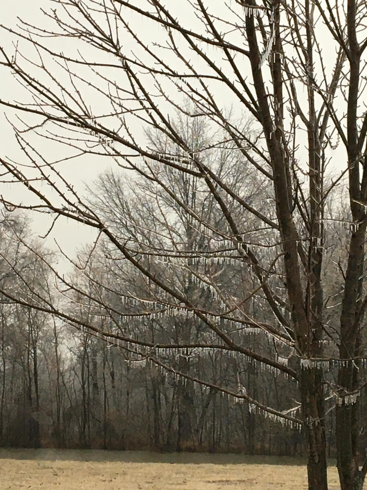
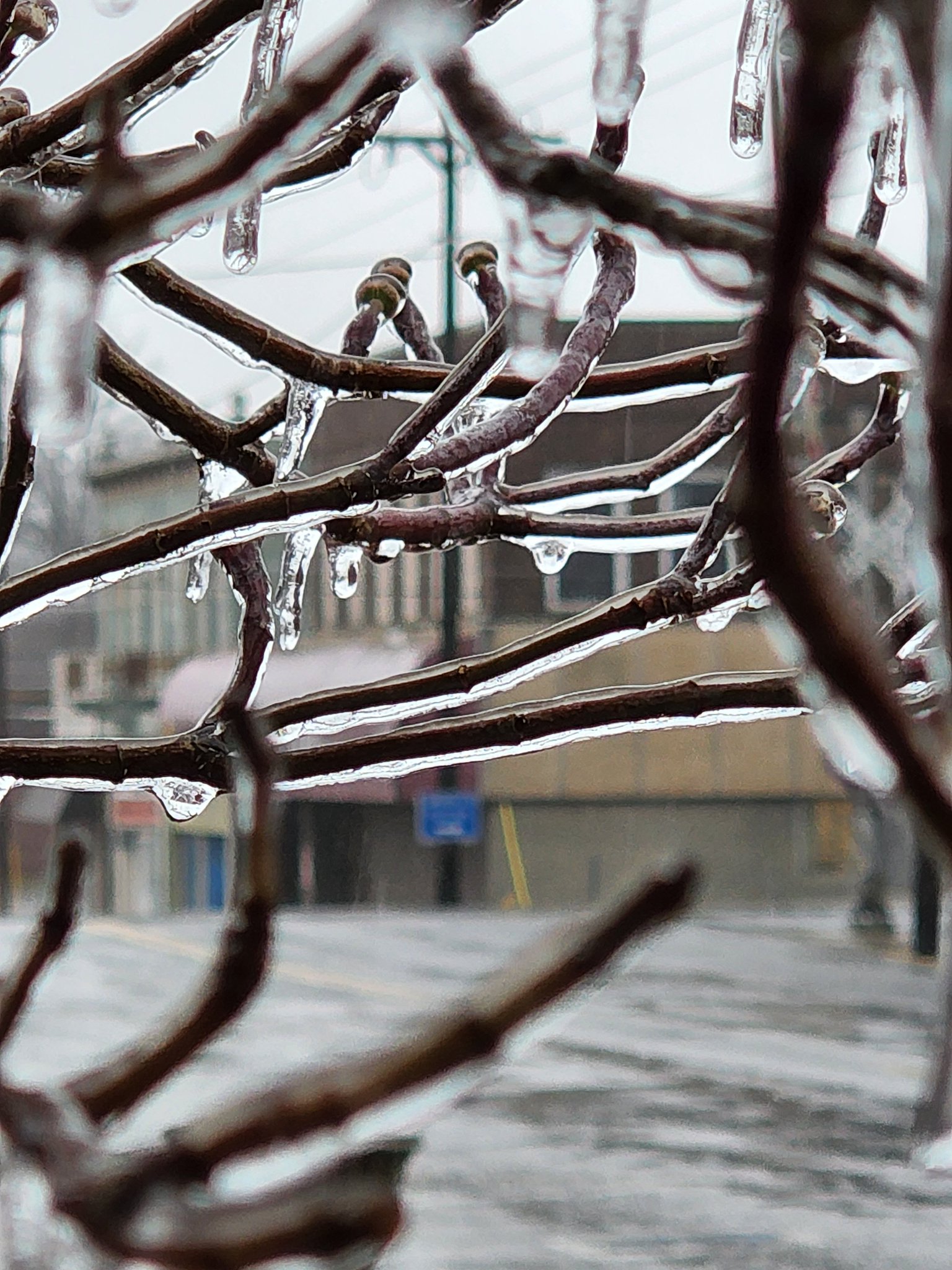
Photos of freezing rain and sleet accumulation from around the area. Click a photo to enlarge.
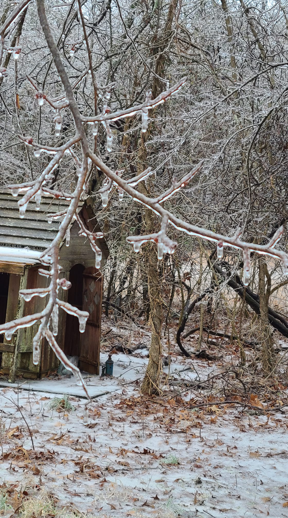 |
 |
 |
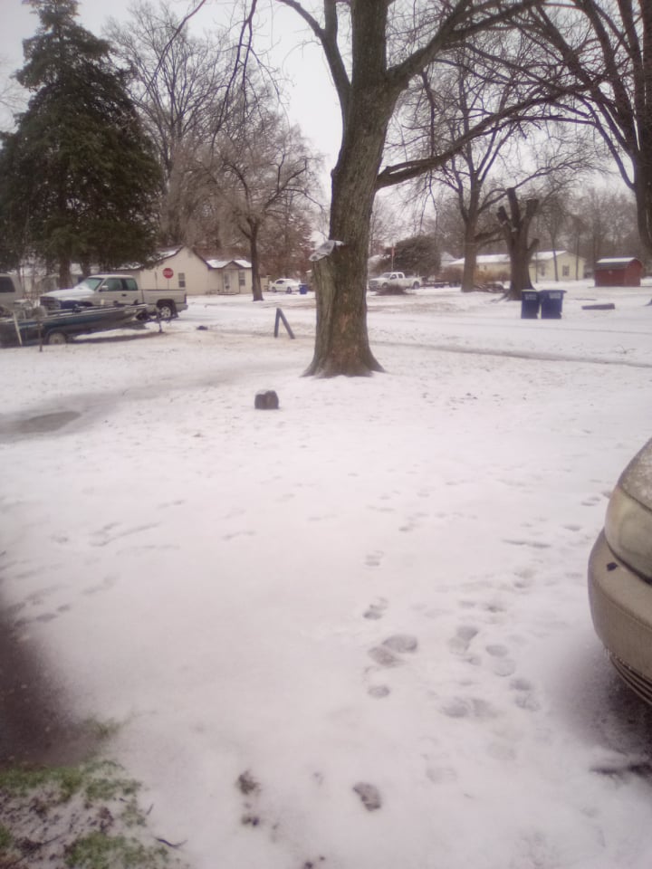 |
| Doniphan, MO (Brandie Hill and Noah Bergren/WPSD) |
Marion, IL (Cody Simmerman) |
Johnston City, IL (JJ Diebolt) |
Western Perry County, IL (NWS Paducah Trained Spotter) |
 |
 |
 |
 |
| Jackson, MO (AJ Blackwell) |
Cobden, IL (Leo Driscol) |
Lake of Egypt, IL (Chad Beaumont and Noah Bergren/WPSD) |
Johnston City, IL (JJ Diebolt) |
Radar
Click here for a radar loop of this winter storm.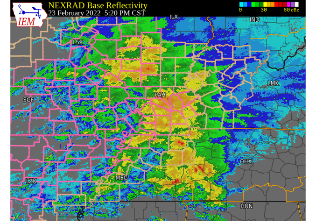 |
| Composite radar image at 5:20 PM CST Wednesday, Feb. 23 courtesy of the Iowa State Mesonet Archive |
Storm Reports
PRELIMINARY LOCAL STORM REPORT...SUMMARY
NATIONAL WEATHER SERVICE PADUCAH KY
840 PM CST THU FEB 24 2022

..TIME...   ...EVENT...      ...CITY LOCATION...     ...LAT.LON...
..DATE...   ....MAG....      ..COUNTY LOCATION..ST.. ...SOURCE....
            ..REMARKS..

0800 PM     SLEET            DE SOTO                 37.82N 89.23W
02/24/2022  M0.3 INCH        JACKSON            IL   TRAINED SPOTTER


0800 PM     FREEZING RAIN    DE SOTO                 37.81N 89.22W
02/24/2022  M0.30 INCH       JACKSON            IL   TRAINED SPOTTER

            0.3 INCHES OF ICE MEASURED ON ELEVATED
            SURFACES.

0615 PM     FREEZING RAIN    JACKSON                 37.38N 89.65W
02/24/2022  E0.40 INCH       CAPE GIRARDEAU     MO   PUBLIC

            RELAYED VIA FACEBOOK.

0600 PM     ICE STORM        4 SE CARBONDALE         37.68N 89.17W
02/24/2022                   JACKSON            IL   FIRE DEPT/RESCUE

            TREE UPROOTED BY ICE ON GIANT CITY ROAD. THE
            TREE FELL INTO A POWER LINE AND CAUGHT ON
            FIRE.

0547 PM     ICE STORM        BUCKNER                 37.98N 89.02W
02/24/2022                   FRANKLIN           IL   EMERGENCY MNGR

            LARGE TREE LIMB DOWNED DUE TO ICE ACCRETION
            IN BUCKNER.

0407 PM     FREEZING RAIN    JOHNSTON CITY           37.82N 88.93W
02/24/2022  M0.15 INCH       WILLIAMSON         IL   TRAINED SPOTTER

            TREES ARE ICING UP, BUT MAIN ROADS ARE JUST
            WET.

0400 PM     SLEET            CUTLER                  38.03N 89.57W
02/24/2022  M0.5 INCH        PERRY              IL   TRAINED SPOTTER

            RELAYED VIA FACEBOOK.

0330 PM     FREEZING RAIN    CARBONDALE              37.73N 89.22W
02/24/2022  M0.39 INCH       JACKSON            IL   TRAINED SPOTTER

            0.39 LIQUID TOTAL. MAINLY FREEZING RAIN WITH
            SOME SLEET. EVERGREEN TREES DROOPING.

0311 PM     FREEZING RAIN    2 SE HEATH              37.07N 88.77W
02/24/2022  M0.04 INCH       MCCRACKEN          KY   ASOS

            SIX HOUR FLAT ICE ACCUMULATION. ASOS STATION
            KPAH PADUCAH KY.

0311 PM     FREEZING RAIN    3 WNW SCOTT CITY        37.23N 89.58W
02/24/2022  M0.18 INCH       SCOTT              MO   ASOS

            SIX HOUR FLAT ICE ACCUMULATION. ASOS STATION
            KCGI CAPE GIRARDEAU MO.

0311 PM     FREEZING RAIN    5 W ASH HILL            36.77N 90.32W
02/24/2022  M0.12 INCH       BUTLER             MO   ASOS

            SIX HOUR FLAT ICE ACCUMULATION. ASOS STATION
            KPOF POPLAR BLUFF MO.

0307 PM     FREEZING RAIN    3 SSW DE SOTO           37.78N 89.25W
02/24/2022  M0.22 INCH       JACKSON            IL   ASOS

            SIX HOUR FLAT ICE ACCUMULATION. ASOS STATION
            KMDH CARBONDALE IL.

0210 PM     FREEZING RAIN    JOHNSTON CITY           37.82N 88.93W
02/24/2022  M0.07 INCH       WILLIAMSON         IL   TRAINED SPOTTER

            RADIAL ICE ACCRETION.

0208 PM     HAIL             3 SSE HANSON            37.38N 87.44W
02/24/2022  E0.25 INCH       HOPKINS            KY   TRAINED SPOTTER


0140 PM     FREEZING RAIN    4 WSW CARBONDALE        37.70N 89.28W
02/24/2022  U0.00 INCH       JACKSON            IL   TRAINED SPOTTER

            MINOR TREE AND LIMB DAMAGE DUE TO ICE
            BUILDUP WITH SOME POWER OUTAGES.

1241 PM     SLEET            5 NNW OXLY              36.66N 90.71W
02/24/2022  M0.6 INCH        RIPLEY             MO   TRAINED SPOTTER

            AVERAGE OF MEASUREMENTS. THUNDER FREEZING
            RAIN ALSO OCCURRED.

1212 AM     SLEET            2 SE HEATH              37.07N 88.77W
02/24/2022  M0.2 INCH        MCCRACKEN          KY   OFFICIAL NWS OBS

            MIDNIGHT COOPERATIVE OBSERVATION AT NWS
            PADUCAH KENTUCKY. SLEET DEPTH INCLUDES A
            TRACE OF ICE. OCCURRED BETWEEN 335 PM AND 9
            PM CST.

1115 PM     SLEET            3 NNW AURORA            36.82N 88.16W
02/23/2022  E0.4 INCH        MARSHALL           KY   PUBLIC

            SLEET AND FREEZING RAIN ACCUMULATION. TREE
            LIMBS ARE BEGINNING TO SAG.

0842 PM     FREEZING RAIN    POWDERLY                37.23N 87.16W
02/23/2022  E0.10 INCH       MUHLENBERG         KY   PUBLIC

            DRIVEWAY IS LIKE AN ICE RINK.

0836 PM     SLEET            2 SE OWENSBORO          37.74N 87.09W
02/23/2022  E0.4 INCH        DAVIESS            KY   PUBLIC


0830 PM     SLEET            2 NNE VERGENNES         37.92N 89.33W
02/23/2022  M0.2 INCH        JACKSON            IL   PUBLIC


0617 PM     SLEET            3 E EVANSVILLE          37.98N 87.48W
02/23/2022  E0.1 INCH        VANDERBURGH        IN   PUBLIC

            MULTIPLE SLICK SPOTS ON ROADWAYS. LLOYD
            EXPRESSWAY HAD A CAR TURNED FROM SLICK SPOTS
            ON THE HIGHWAY.

0610 PM     SLEET            LA CENTER               37.07N 88.97W
02/23/2022  E0.5 INCH        BALLARD            KY   PUBLIC


0600 PM     SLEET            DU QUOIN                38.00N 89.24W
02/23/2022  M0.4 INCH        PERRY              IL   EMERGENCY MNGR

            PRIMARY AND SECONDARY ROADS ARE ALL COVERED
            BY SLEET.

0600 PM     SLEET            MURRAY                  36.61N 88.32W
02/23/2022  M0.1 INCH        CALLOWAY           KY   TRAINED SPOTTER

            MAIN AND SECONDARY ROADS ARE EXTREMELY
            SLICK. SEVERAL ACCIDENTS REPORTED.

0550 PM     SLEET            BENTON                  36.85N 88.36W
02/23/2022  E0.1 INCH        MARSHALL           KY   TRAINED SPOTTER

            ROADS AND SIDEWALKS BECOMING SLICK AND
            HAZARDOUS.

0509 PM     SLEET            POPLAR BLUFF            36.76N 90.41W
02/23/2022  M0.3 INCH        BUTLER             MO   EMERGENCY MNGR

            ROADS ARE COVERED BY SLEET ACCUMULATION.

0454 PM     FREEZING RAIN    5 NNW OXLY              36.66N 90.72W
02/23/2022  E0.15 INCH       RIPLEY             MO   TRAINED SPOTTER

            FREEZING RAIN ACCUMULATION ESTIMATED BETWEEN
            0.1 AMD 0.2 INCHES. CURRENTLY SEEING LIGHT
            FREEZING RAIN.

0454 PM     SLEET            5 NNW OXLY              36.66N 90.71W
02/23/2022  M0.3 INCH        RIPLEY             MO   TRAINED SPOTTER

            PRECIPITATION HAS TRANSITIONED TO FREEZING
            RAIN.

0351 PM     SLEET            EAST PRAIRIE            36.78N 89.38W
02/23/2022  M0.3 INCH        MISSISSIPPI        MO   TRAINED SPOTTER

            SLEET ACCUMULATION BEGINNING ON ROADS.

0215 PM     FREEZING RAIN    DUDLEY                  36.79N 90.09W
02/23/2022  E0.00 INCH       STODDARD           MO   TRAINED SPOTTER

            LIGHT FREEZING RAIN HAS BEGUN, AND IS
            FREEZING TO SOME SURFACES AT GROUND LEVEL.
            TEMP 27 DEGREES.

0215 PM     SLEET            5 NNW OXLY              36.66N 90.71W
02/23/2022  M0.1 INCH        RIPLEY             MO   TRAINED SPOTTER

            GROUND AND ROOFS ALMOST WHITE WITH SLEET.
            METAL BIRD FEEDERS HAVE ONE INCH PLUS
            ICICLES. CURRENT CONDITIONS, LIGHT TO
            OCCASIONALLY MODERATE FREEZING RAIN MIXED
            WITH SLEET. TEMPERATURE 26.3.
 |
Media use of NWS Web News Stories is encouraged! Please acknowledge the NWS as the source of any news information accessed from this site. |
|

