Overview
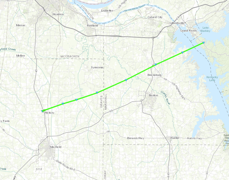
An extremely active period of severe weather impacted the region for four consecutive days, between June 29 and July 2, 2023. Numerous rounds of severe thunderstorms produce large hail up to three inches in diameter and destructive damaging winds. The Wabash Valley and Evansville Tri-State area were impacted particularly hard, with several hundred people losing power for multiple days due to repeated rounds of severe thunderstorms. A long-track EF-1 tornado struck Graves, Marshall, and Lyon counties in western Kentucky on the evening of July 1.Tornadoes:
|
Tornado - Hickory to Grand Rivers, KY
|
||||||||||||||||
The Enhanced Fujita (EF) Scale classifies tornadoes into the following categories:
| EF0 Weak 65-85 mph |
EF1 Moderate 86-110 mph |
EF2 Significant 111-135 mph |
EF3 Severe 136-165 mph |
EF4 Extreme 166-200 mph |
EF5 Catastrophic 200+ mph |
 |
|||||
Wind & Hail:
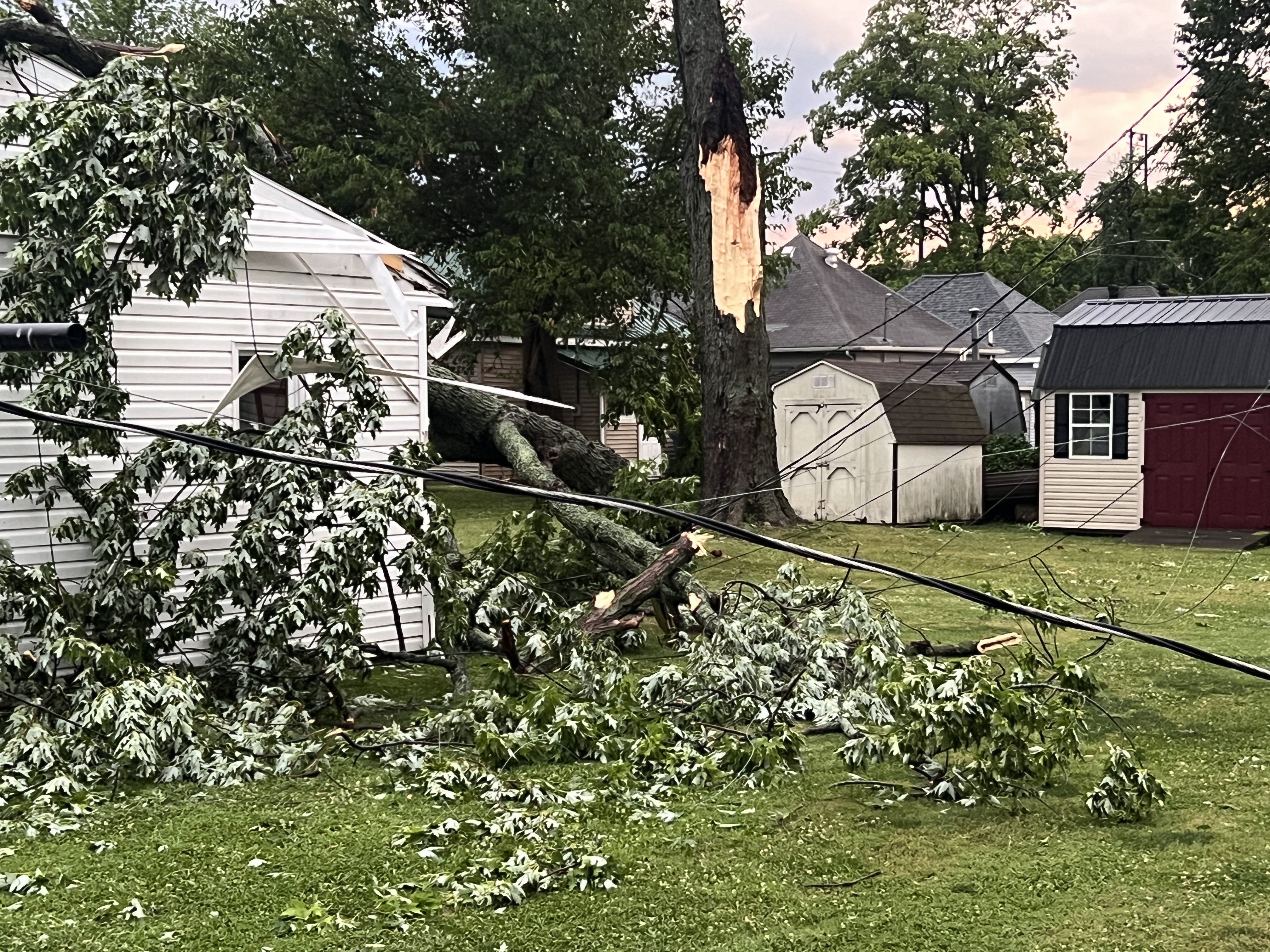
Much of the severe thunderstorms that impacted the area during the June 29 to July 2 period produced damaging winds and large hail.
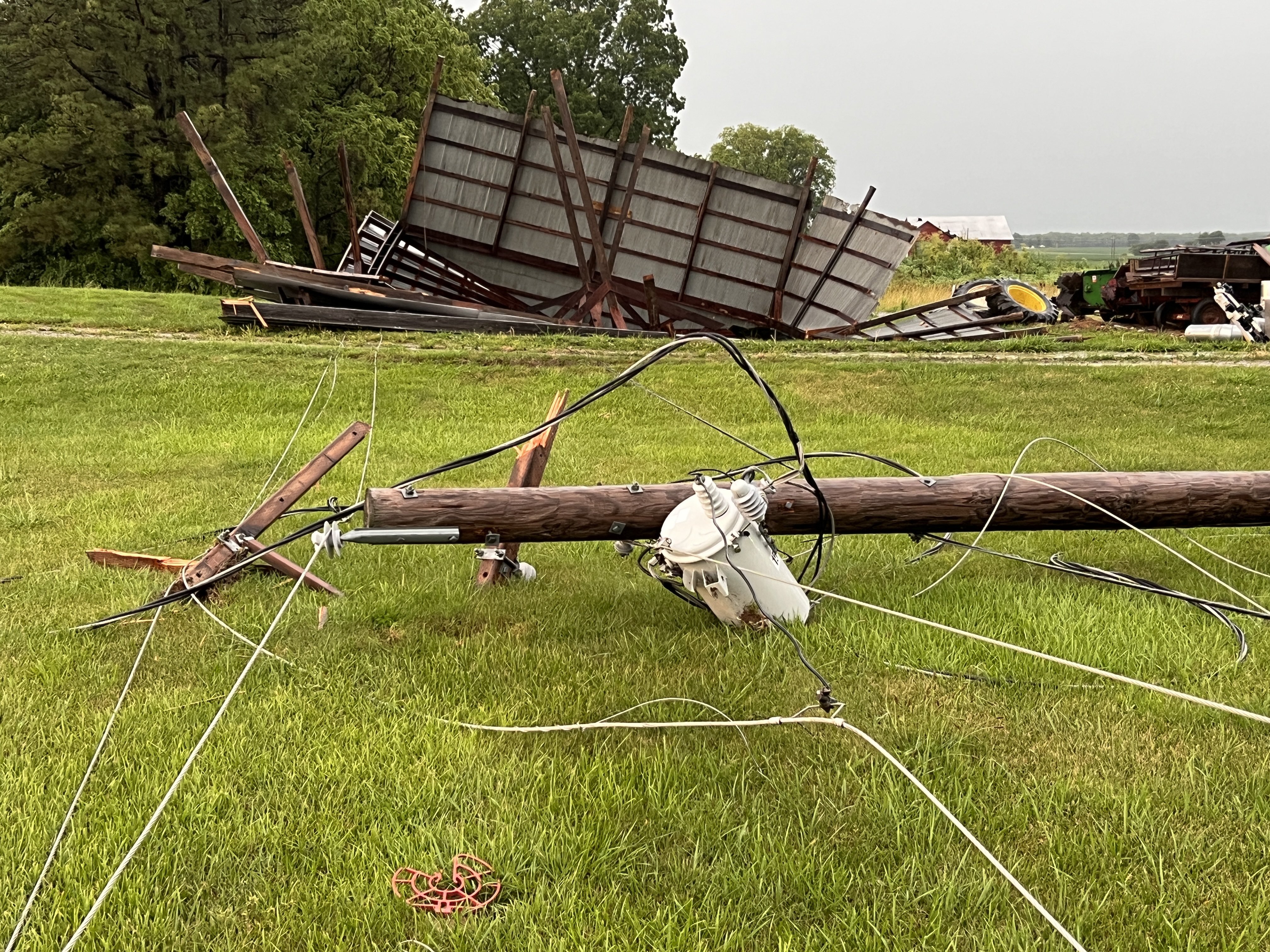
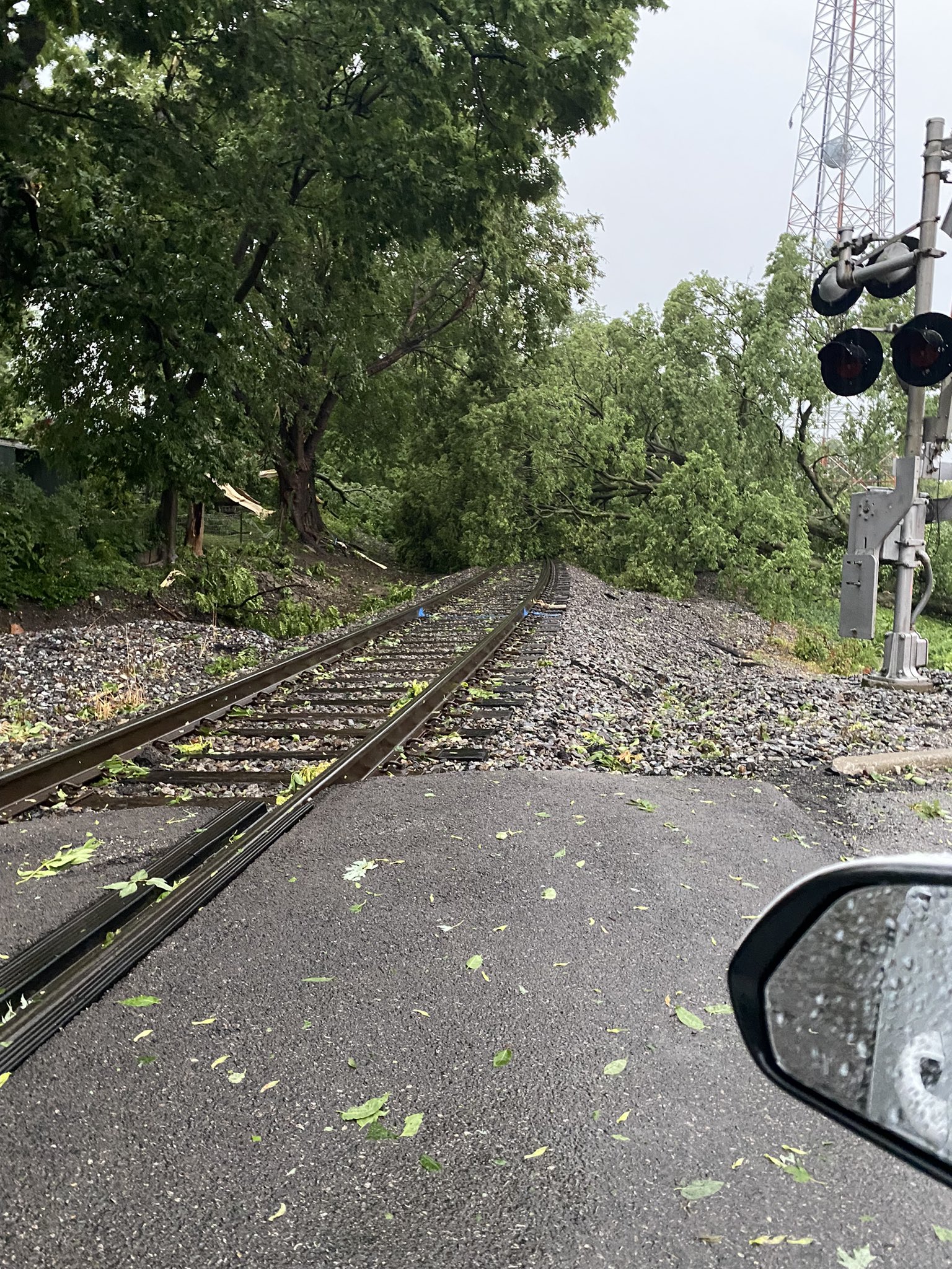
Wind
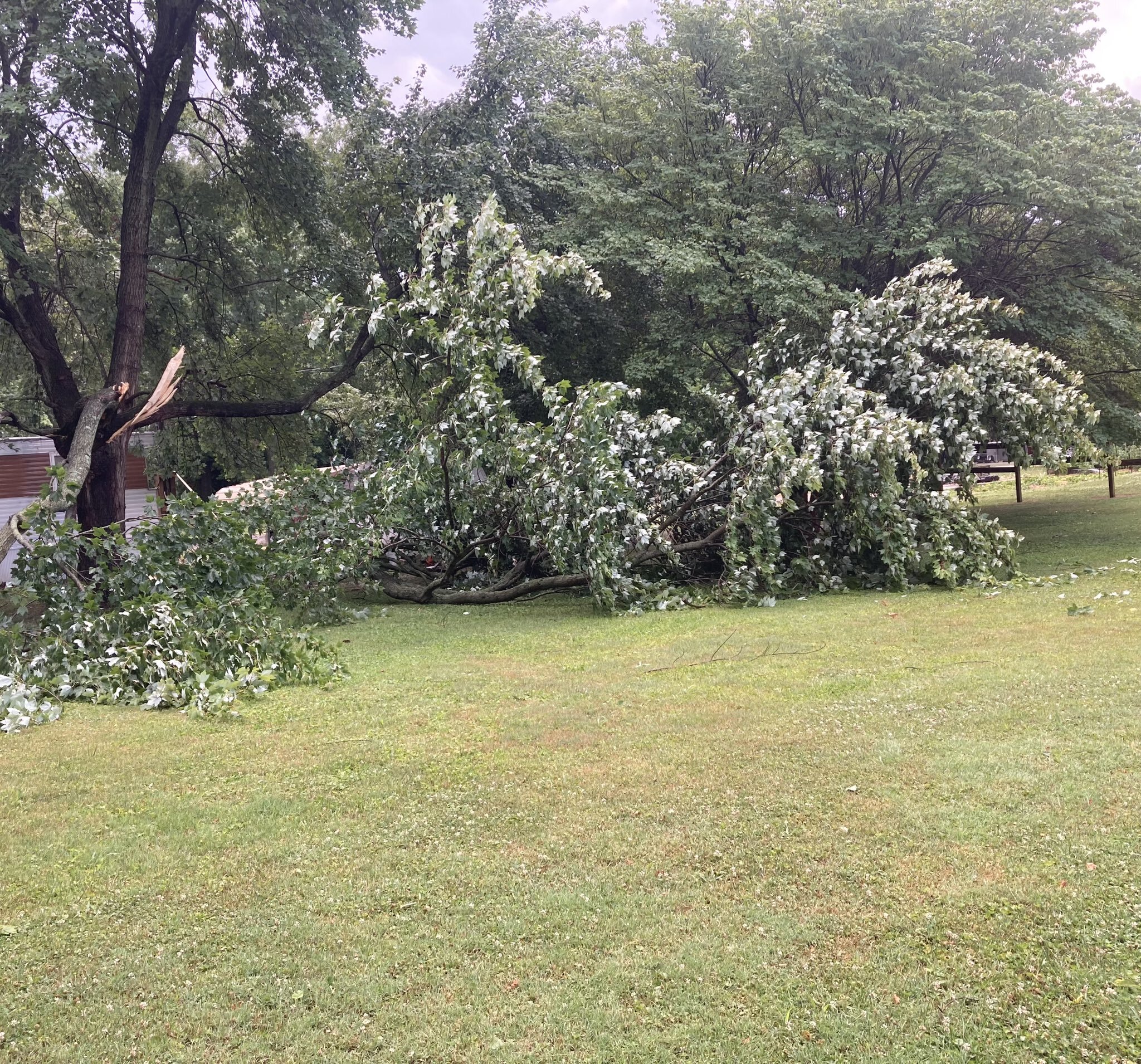
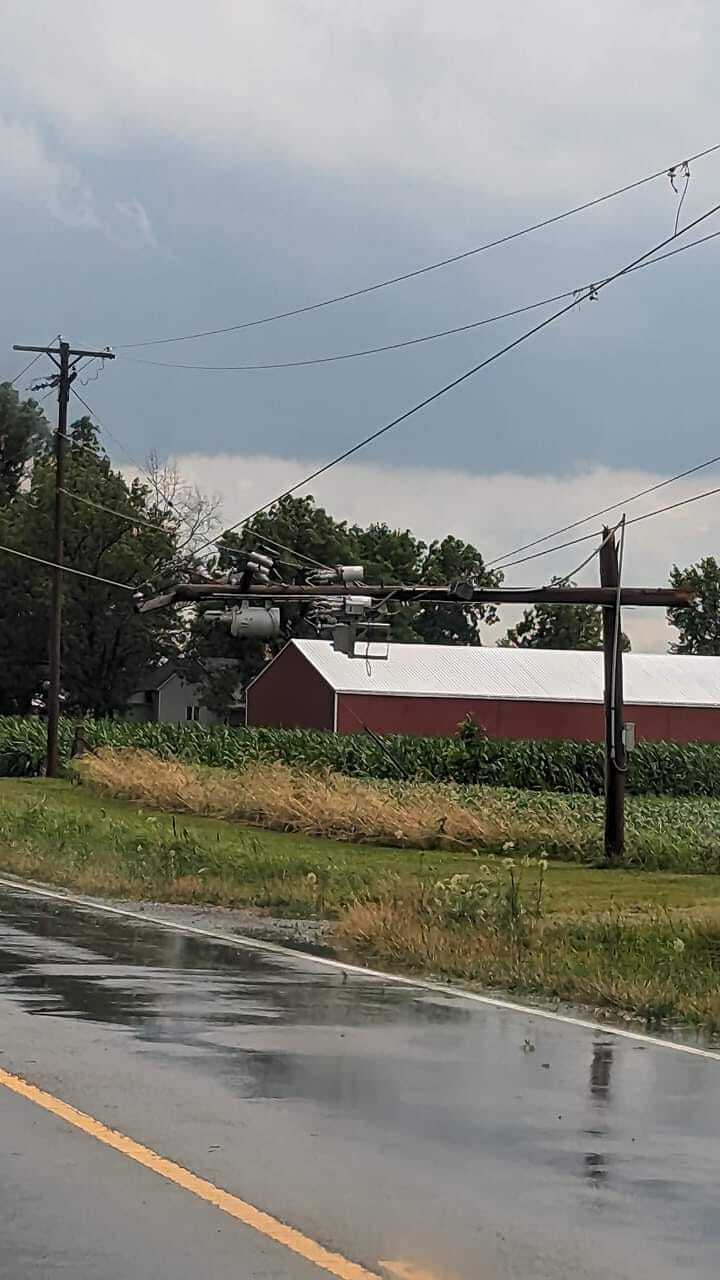
Some of the worst wind damage occurred across the Wabash River Valley. The towns of Mount Carmel, IL, and Albion, IL, suffered significant damage to trees and power lines.
 |
 |
 |
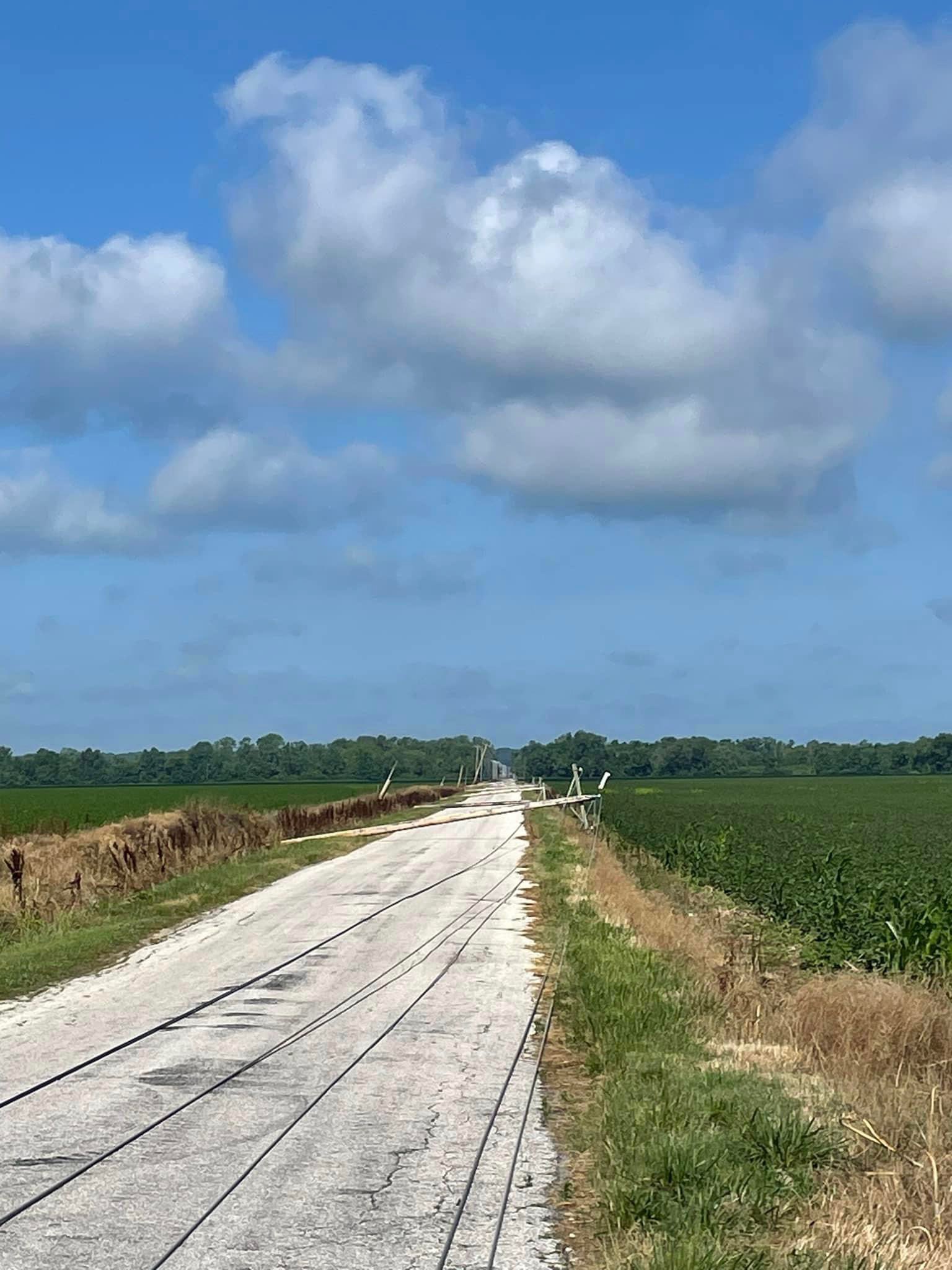 |
| Barn damage south of Albion, IL (Charles Peek/The Weather Channel) | Trees down over railroad tracks in Mount Carmel, IL (Jeff Blair) | Trees and power lines down in Mount Carmel, IL (Charles Peek/The Weather Channel) | Downed power poles in Gibson County, IN (Win Energy REMC) |
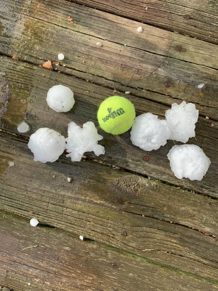
Hail
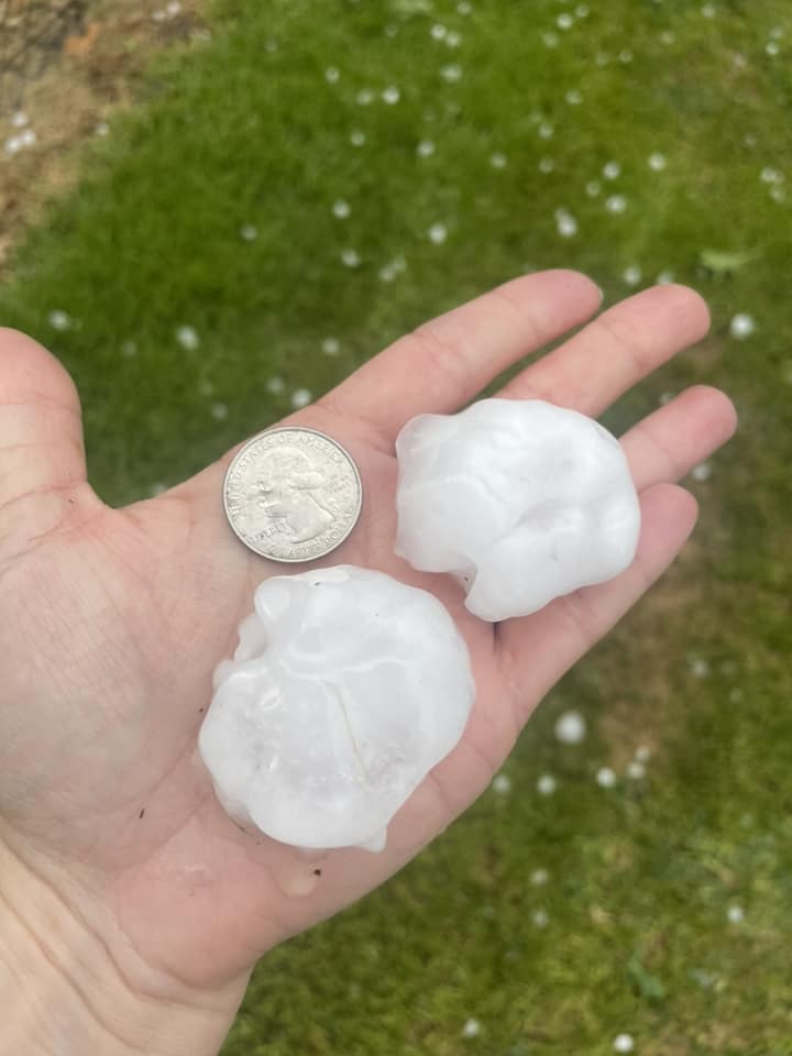
Very large hail fell across the region the four days of severe weather. The largest hail stones were up to three inches in diameter and fell on June 30 in portions of southern Illinois.
 |
 |
 |
 |
| Hail in Marion, IL (Sarah Anderson) |
Tennis ball sized hail near Johnston City, IL (Nick Hausen/WSIL-TV) | Hail in Tamaroa, IL Leigha C. Huggins) |
Windows broken by large hail in Marion, IL (Luke Saeger/Franklin County EMA) |
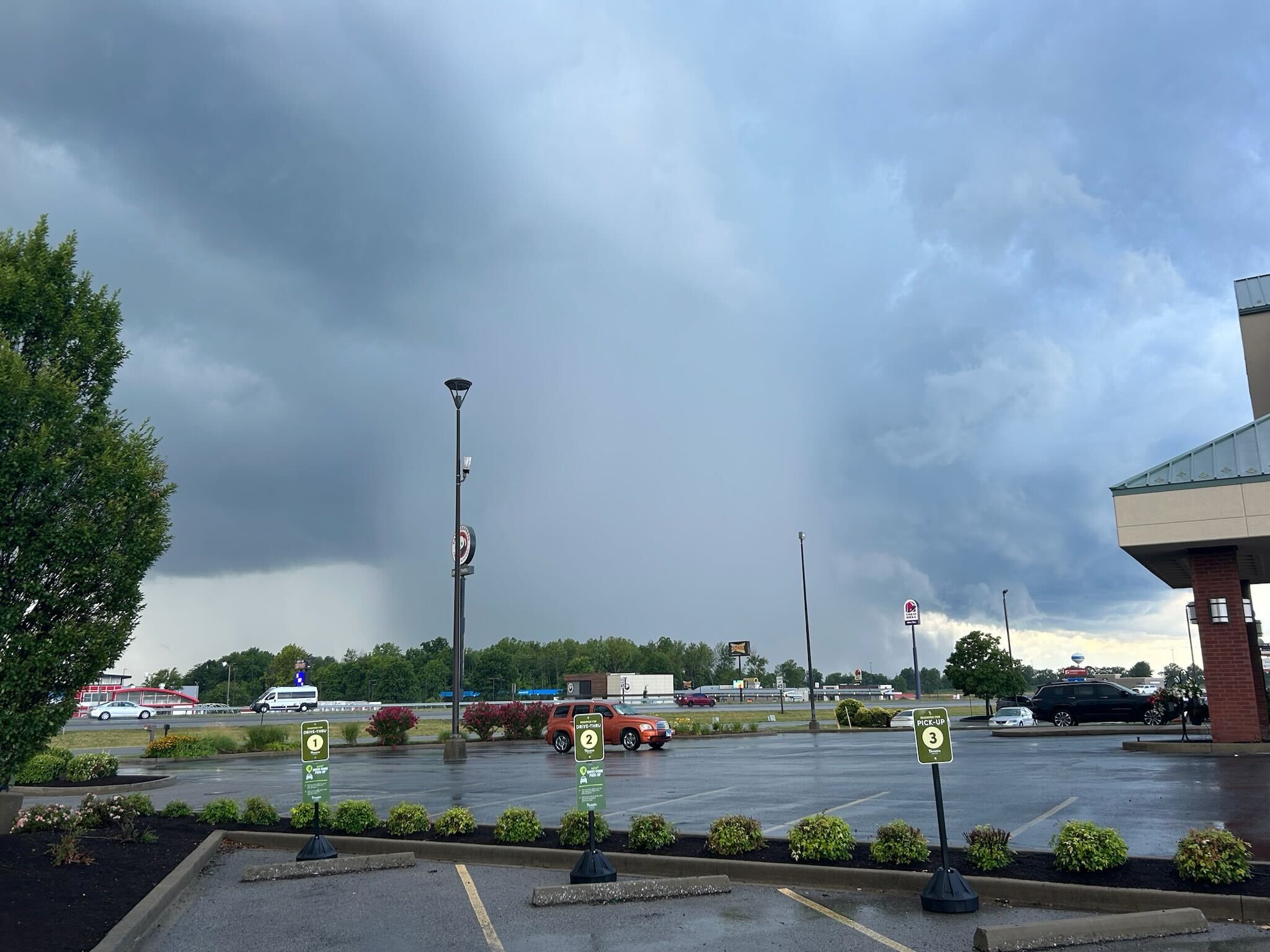
Photos & Video
 |
 |
 |
 |
| Downburst that produced a 70 mph wind gust in Marion, IL (Nick Hausen/WSIL-TV) |
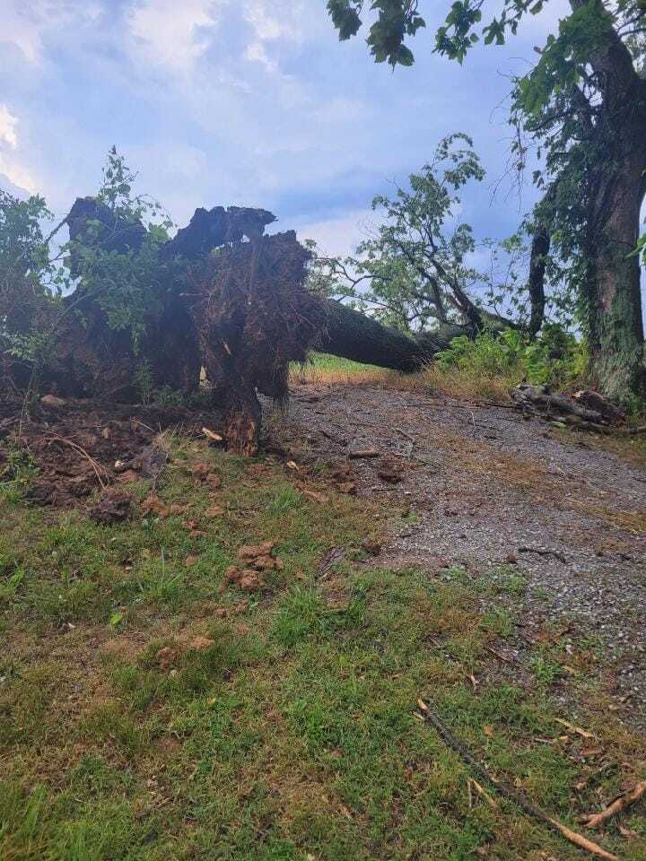
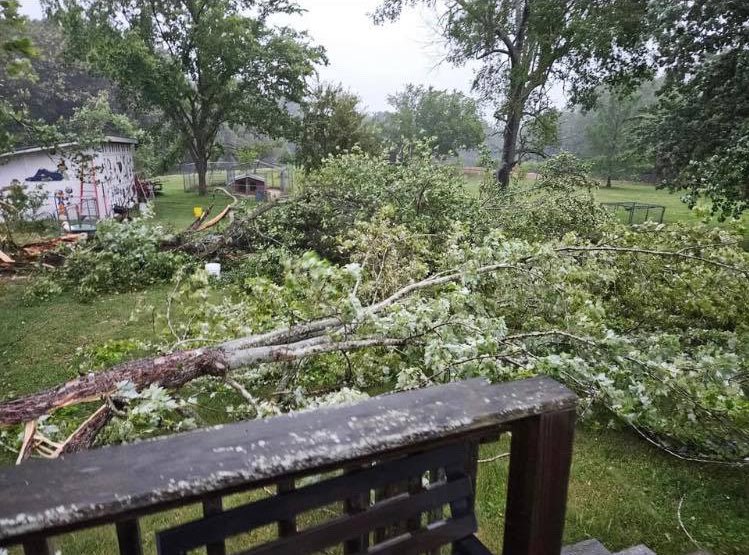
Downed tree in New Columbia, IL (Beau Dodson) |
Downed tree limbs in Norris City, IL (Beau Dodson) |
Snapped power pole in Williamson County, IL (Beau Dodson) |
 |
 |
 |
 |
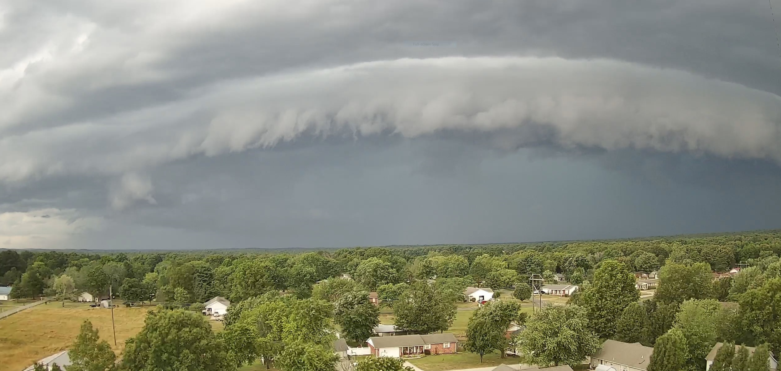
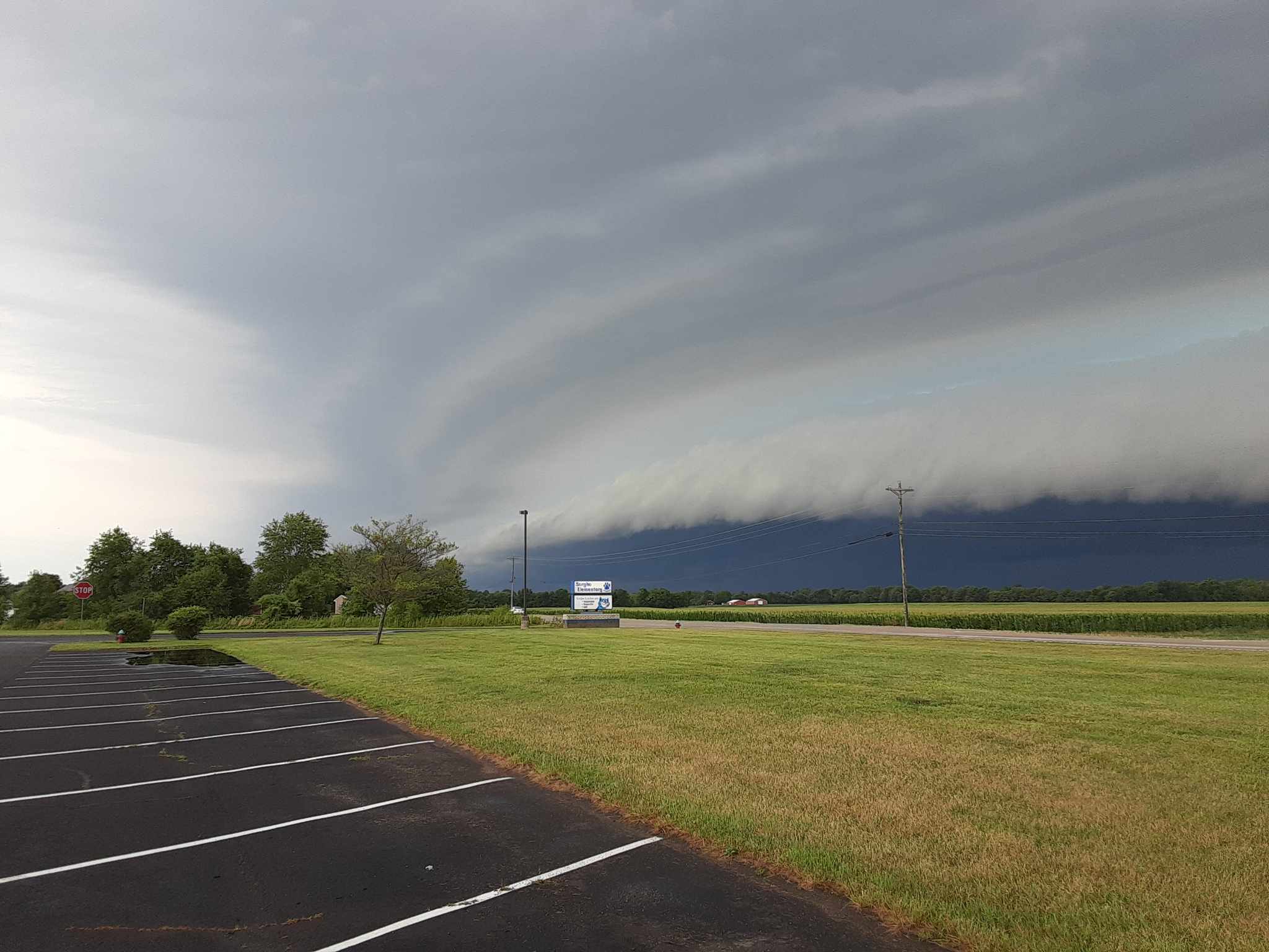
| Shelf cloud in Poplar Bluff, MO (Steve Seawright) |
Golf ball size hail in Benton, IL (Beau Dodson) |
Shelf cloud in western Daviess County, KY (Tim Crabtree) |
Tree damage in Lamasco, KY (Jennifer Rukavina Bidwell) |
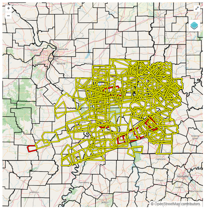
Storm Reports

Over the four day period, 238 reports of severe hail, thunderstorm wind damage, or severe thunderstorm wind gusts were reported to NWS Paducah.
Preliminary Local Storm Report...Summary
National Weather Service Paducah KY
536 AM CDT Mon Jul 3 2023
..TIME... ...EVENT... ...CITY LOCATION... ...LAT.LON...
..DATE... ....MAG.... ..COUNTY LOCATION..ST.. ...SOURCE....
..REMARKS..
0745 AM Hail Oakland City 38.34N 87.35W
06/29/2023 E1.75 inch Gibson IN Trained Spotter
Hail ranging from ping pong to golf ball
sized in Oakland City.
0745 AM Tstm Wnd Dmg Francisco 38.33N 87.45W
06/29/2023 Gibson IN Trained Spotter
Trees down and roof blown off of shed.
0750 AM Tstm Wnd Gst Francisco 38.33N 87.45W
06/29/2023 E60 MPH Gibson IN Cocorahs
Estimated 50 to 60 mph winds.
0828 AM Tstm Wnd Dmg 2 ESE Tennyson 38.07N 87.08W
06/29/2023 Spencer IN Public
Horse Barn Destroyed. Time Estimated by
Radar.
0842 AM Flash Flood 2 SSE Petersburg 38.46N 87.26W
06/29/2023 Pike IN Public
Water flowing across highway 61 south of
Peterburg. Road is being closed. Additional
water over many roads in the town of
Petersburg.
0844 AM Tstm Wnd Dmg Rockport 37.89N 87.05W
06/29/2023 Spencer IN Trained Spotter
Semis blown over on US 231 in Rockport.
0847 AM Rain Oakland City 38.34N 87.35W
06/29/2023 M4.31 inch Gibson IN Mesonet
Mesonet station AR793 Oakland City IN. 3.42
inches occurred in the past hour.
0850 AM Tstm Wnd Dmg Francisco 38.33N 87.45W
06/29/2023 Gibson IN Emergency Mngr
Trees down, Mobile home blown over with
entrapment.
0855 AM Tstm Wnd Dmg Grandview 37.94N 86.98W
06/29/2023 Spencer IN Emergency Mngr
Numerous trees snapped or uprooted in the
town of Grandview.
0858 AM Tstm Wnd Dmg 2 WSW Elberfeld 38.15N 87.49W
06/29/2023 Vanderburgh IN Trained Spotter
Awning destroyed by wind.
0910 AM Tstm Wnd Dmg Rockport 37.89N 87.05W
06/29/2023 Spencer IN Emergency Mngr
Garage roof damaged by tree falling onto it.
Late report.
0912 AM Tstm Wnd Dmg Grandview 37.94N 86.98W
06/29/2023 Spencer IN Emergency Mngr
Multiple trees down in the area.
0913 AM Flash Flood 2 WSW Oakland City 38.33N 87.39W
06/29/2023 Gibson IN Trained Spotter
Water over road on Hwy 64 east of the I-69
interchange.
0915 AM Tstm Wnd Gst 3 WNW Newburgh 37.97N 87.46W
06/29/2023 E70 MPH Vanderburgh IN Public
0918 AM Tstm Wnd Gst 3 SE Evansville 37.95N 87.51W
06/29/2023 E70 MPH Vanderburgh IN Public
Spotter estimates 70 mph gusts.
0919 AM Flash Flood Oakland City 38.34N 87.35W
06/29/2023 Gibson IN Public
Flash Flooding into buildings and homes.
0920 AM Tstm Wnd Gst Evansville 37.99N 87.55W
06/29/2023 E40 MPH Vanderburgh IN Public
0921 AM Tstm Wnd Dmg 3 ENE Owensboro 37.77N 87.07W
06/29/2023 Daviess KY Emergency Mngr
EM reports trees down blocking roads.
0922 AM Tstm Wnd Gst 8 W Rockport 37.91N 87.20W
06/29/2023 U60 MPH Spencer IN Public
Report of Very High Winds.
0923 AM Hail Evansville 37.98N 87.54W
06/29/2023 M0.25 inch Vanderburgh IN Public
Pea size hail and heavy rain.
0951 AM Rain 1 SSE Petersburg 38.47N 87.27W
06/29/2023 M4.11 inch Pike IN Public
Personal weather station. Most of this rain
occurred within 90 minutese.
0952 AM Rain 4 NNE Spurgeon 38.30N 87.22W
06/29/2023 M4.14 inch Pike IN Public
personal weather station. most of this rain
occurred within 90 minutes.
0953 AM Rain 7 SE Hazleton 38.43N 87.44W
06/29/2023 M3.36 inch Gibson IN Public
personal weather station. most of this rain
occurred within 90 minutes.
1000 AM Flash Flood 2 WNW Philpot 37.74N 87.03W
06/29/2023 Daviess KY Emergency Mngr
Water rescue underway on Stonegate Drive
(off of Hwy 54 east of Owensboro).
1000 AM Rain Lynnville 38.20N 87.31W
06/29/2023 M3.87 inch Warrick IN Cocorahs
Rainfall total in Lynnville this morning.
1030 AM Rain 3 W Petersburg 38.50N 87.34W
06/29/2023 M5.33 inch Pike IN Trained Spotter
Personal weather station west of Petersburg.
Over 4 inches occurred within 90 minutes.
This is rainfall since 7 AM this morning.
1032 AM Flash Flood 2 WSW Owensboro 37.75N 87.15W
06/29/2023 Daviess KY Trained Spotter
Road flooded , vehicles unable to drive
through.
1056 AM Tstm Wnd Dmg 1 SE Madisonville 37.33N 87.50W
06/29/2023 Hopkins KY Public
Large oak tree snapped in Madisonville.
1100 AM Rain 3 E Philpot 37.73N 86.93W
06/29/2023 M3.38 inch Daviess KY Public
Personal weather station. Storm total this
morning so far.
1101 AM Hail 3 SSE Drakesboro 37.18N 87.03W
06/29/2023 E0.25 inch Muhlenberg KY Public
1119 AM Rain 4 S Tennyson 38.03N 87.13W
06/29/2023 M3.99 inch Spencer IN Cocorahs
rain report from the past 3 hours.
1145 AM Flash Flood Grandview 37.94N 86.98W
06/29/2023 Spencer IN Emergency Mngr
Flooding of many streets in Grandview. Also
flooding in Chrisney area.
1158 AM Hail 1 SE Elkton 36.80N 87.15W
06/29/2023 E0.25 inch Todd KY Public
1211 PM Flash Flood 2 ENE Masonville 37.68N 87.00W
06/29/2023 Daviess KY Emergency Mngr
Family rescued from high water at their
home. Flooding countywide.
0200 PM Rain 2 ESE Petersburg 38.48N 87.26W
06/29/2023 M4.05 inch Pike IN Public
Rainfall total so far today from Tempest
Personal Weather Station.
0200 PM Rain Chrisney 38.01N 87.03W
06/29/2023 M3.20 inch Spencer IN Public
Rainfall total so far today at Tempest
Personal Weather Station.
0204 PM Rain 3 NE Henderson 37.87N 87.55W
06/29/2023 E3.27 inch Henderson KY Public
Rainfall total so far today at Tempest
Personal Weather Station.
0205 PM Rain 1 W Central City 37.30N 87.15W
06/29/2023 M2.60 inch Muhlenberg KY Public
Rainfall total so far today at Tempest
Personal Weather Station.
0207 PM Rain 4 W Evansville 38.00N 87.62W
06/29/2023 M2.50 inch Vanderburgh IN Public
Rainfall total so far today at Tempest
Personal Weather Station.
0207 PM Rain 7 WNW Evansville 38.01N 87.66W
06/29/2023 M2.76 inch Vanderburgh IN Public
Rainfall total so far today at Tempest
Personal Weather Station.
0247 PM Hail 3 SSE Aurora 36.74N 88.13W
06/29/2023 M0.25 inch Calloway KY Trained Spotter
0255 PM Tstm Wnd Dmg Oakland City 38.34N 87.35W
06/29/2023 Gibson IN Trained Spotter
Numerous trees down and most of town without
power.
0309 PM Tstm Wnd Dmg 4 WNW Mount Carmel 38.43N 87.84W
06/29/2023 Wabash IL Emergency Mngr
Report of Multiple Trees Down.
0313 PM Hail Princeton 38.36N 87.57W
06/29/2023 E0.25 inch Gibson IN Public
0314 PM Flash Flood 2 E Oakland City 38.34N 87.31W
06/29/2023 Pike IN Emergency Mngr
Water flowing over Hwy 64 near Gibson-Pike
County lines.
0314 PM Hail Fairfield 38.38N 88.37W
06/29/2023 E0.25 inch Wayne IL Public
0315 PM Tstm Wnd Dmg Dale 38.17N 86.99W
06/29/2023 Spencer IN Trained Spotter
Shingle blown off home. Also, tree down on
truck.
0320 PM Rain 4 W Petersburg 38.50N 87.35W
06/29/2023 M6.36 inch Pike IN Public
Personal weather station has measured 6.36
inches of rain so far today. Matches up
perfectly with radar estimates west of
Petersburg.
0331 PM Hail Herrin 37.80N 89.03W
06/29/2023 M0.25 inch Williamson IL Trained Spotter
0335 PM Hail Johnston City 37.82N 88.92W
06/29/2023 M1.00 inch Williamson IL Emergency Mngr
Quarter sized hail.
0335 PM Hail Johnston City 37.82N 88.93W
06/29/2023 E1.25 inch Williamson IL Public
Quarter to nearly half dollar sized hail.
0335 PM Tstm Wnd Gst Owensboro 37.77N 87.11W
06/29/2023 E60 MPH Daviess KY Trained Spotter
Estimated 60 mph winds.
0339 PM Hail 1 WSW Spillertown 37.76N 88.94W
06/29/2023 E0.70 inch Williamson IL Public
0345 PM Flash Flood 2 N Fort Branch 38.28N 87.57W
06/29/2023 Gibson IN Broadcast Media
Part of U.S. Hwy 41 just south of Toyota
Plant has water over it. Several ditches out
of their bank.
0345 PM Tstm Wnd Gst 1 ENE Lynnville 38.20N 87.30W
06/29/2023 M68 MPH Warrick IN Trained Spotter
Trees also down on power lines.
0350 PM Tstm Wnd Dmg Macio 37.87N 86.99W
06/29/2023 Daviess KY Emergency Mngr
Power lines down.
0402 PM Rain Oakland City 38.34N 87.35W
06/29/2023 M5.73 inch Gibson IN Public
Rainfall total at personal weather station
so far today.
0720 PM Hail 4 WNW Mount Carmel 38.43N 87.83W
06/29/2023 M0.70 inch Wabash IL Trained Spotter
0727 PM Hail 4 SW Keensburg 38.32N 87.93W
06/29/2023 E1.75 inch Wabash IL Emergency Mngr
Golfball size hail near the intersection of
county road 350 and State Rt 1.
0735 PM Tstm Wnd Gst 1 ENE Boonville 38.05N 87.26W
06/29/2023 M68 MPH Warrick IN Broadcast Media
Damage to a greenhouse at same locations as
the measured gust.
0744 PM Hail Owensville 38.27N 87.69W
06/29/2023 M1.00 inch Gibson IN Trained Spotter
0806 PM Tstm Wnd Dmg 1 E Evansville 37.99N 87.52W
06/29/2023 Vanderburgh IN Trained Spotter
A maple tree was blown down near 851 Alvord
Blvd in Evansville. Other large limbs down
in the area.
0810 PM Tstm Wnd Gst Darmstadt 38.10N 87.58W
06/29/2023 M80 MPH Vanderburgh IN Trained Spotter
Reports of uprooted trees and shingle damage
in the same area.
0820 PM Hail Newburgh 37.95N 87.41W
06/29/2023 E0.88 inch Warrick IN Broadcast Media
Dime sized hail in downtown Newburgh.
0850 PM Hail 1 SW Owensboro 37.74N 87.13W
06/29/2023 E1.00 inch Daviess KY Emergency Mngr
Dime size hail on Ottawa Dr in Owensboro.
0452 PM Hail 1 NNW Sturgis 37.55N 87.99W
06/30/2023 E0.25 inch Union KY Trained Spotter
0458 PM Hail Makanda 37.62N 89.24W
06/30/2023 E0.25 inch Jackson IL Broadcast Media
0500 PM Hail 5 NE Makanda 37.66N 89.17W
06/30/2023 E1.75 inch Jackson IL Broadcast Media
0501 PM Hail 3 NNE Makanda 37.66N 89.21W
06/30/2023 E1.25 inch Jackson IL Public
Corrects previous hail report from 3 NNE
Makanda.
0502 PM Hail 4 SE Sturgis 37.50N 87.94W
06/30/2023 M0.88 inch Union KY Public
0515 PM Hail 3 ESE Nebo 37.37N 87.58W
06/30/2023 E0.25 inch Hopkins KY Public
0519 PM Hail 2 ESE Crainville 37.74N 89.03W
06/30/2023 E1.00 inch Williamson IL Public
Report from mPING: Quarter (1.00 in.).
0520 PM Hail 2 S Energy 37.75N 89.03W
06/30/2023 M3.00 inch Williamson IL Public
0520 PM Hail Anna 37.46N 89.25W
06/30/2023 E1.75 inch Union IL Public
0521 PM Hail 1 SE Crainville 37.75N 89.05W
06/30/2023 E1.00 inch Williamson IL Broadcast Media
0522 PM Hail 2 ESE Crainville 37.74N 89.02W
06/30/2023 E1.75 inch Williamson IL Emergency Mngr
0524 PM Hail 1 NW Marion 37.74N 88.96W
06/30/2023 E1.00 inch Williamson IL Trained Spotter
Damage to the ballpark.
0524 PM Hail Marion 37.74N 88.94W
06/30/2023 M1.75 inch Williamson IL Public
Numerous damaged vehicles from golf ball
sized hail.
0525 PM Hail 2 WNW Marion 37.74N 88.97W
06/30/2023 E1.75 inch Williamson IL Public
Report from mPING: Golf Ball (1.75 in.).
0525 PM Hail Anna 37.46N 89.24W
06/30/2023 M1.50 inch Union IL Public
0527 PM Hail 1 ENE Marion 37.74N 88.93W
06/30/2023 E1.00 inch Williamson IL Trained Spotter
0528 PM Hail 2 SSE Energy 37.75N 89.01W
06/30/2023 E1.50 inch Williamson IL Public
Airplane at airport has busted windows.
0530 PM Hail 3 SSE Energy 37.74N 89.00W
06/30/2023 E1.75 inch Williamson IL Emergency Mngr
Major damage to multiple vehicles at car
dealership.
0531 PM Hail 1 NE Marion 37.75N 88.93W
06/30/2023 E1.50 inch Williamson IL Law Enforcement
0534 PM Hail Whiteash 37.78N 88.93W
06/30/2023 E1.00 inch Williamson IL Public
Report from mPING: Quarter (1.00 in.).
0535 PM Hail Johnston City 37.82N 88.93W
06/30/2023 M2.75 inch Williamson IL Public
Corrects previous hail report from Johnston
City. Public has dents to car and cracked
windshield.
0537 PM Hail Sturgis 37.55N 87.99W
06/30/2023 M0.70 inch Union KY Public
0537 PM Hail 4 E Anna 37.45N 89.16W
06/30/2023 E1.00 inch Union IL Public
Report from mPING: Quarter (1.00 in.).
0540 PM Hail 1 SE Carbondale 37.71N 89.20W
06/30/2023 M1.75 inch Jackson IL Public
0544 PM Hail 1 N Pittsburg 37.79N 88.85W
06/30/2023 E2.75 inch Williamson IL Trained Spotter
0545 PM Hail Providence 37.40N 87.75W
06/30/2023 M1.50 inch Webster KY Public
0552 PM Hail 1 NE Dixon 37.53N 87.68W
06/30/2023 E0.25 inch Webster KY Emergency Mngr
0554 PM Hail Whiteash 37.79N 88.92W
06/30/2023 M2.75 inch Williamson IL Public
Damaged caused by baseball sized hail.
0603 PM Hail 3 SSE Buncombe 37.42N 88.96W
06/30/2023 E1.75 inch Johnson IL Broadcast Media
0605 PM Hail Cypress 37.37N 89.02W
06/30/2023 M1.00 inch Johnson IL Trained Spotter
0610 PM Hail Dawson Springs 37.18N 87.69W
06/30/2023 E0.25 inch Hopkins KY Trained Spotter
0618 PM Hail Carterville 37.76N 89.08W
06/30/2023 M0.70 inch Williamson IL Amateur Radio
0630 PM Tstm Wnd Dmg Crofton 37.05N 87.48W
06/30/2023 Christian KY Public
Pole barn metal partially peeled off.
0630 PM Hail Murphysboro 37.77N 89.34W
06/30/2023 M0.70 inch Jackson IL Emergency Mngr
0631 PM Hail West Frankfort 37.90N 88.92W
06/30/2023 E0.88 inch Franklin IL Trained Spotter
0631 PM Hail West Frankfort 37.90N 88.93W
06/30/2023 M0.88 inch Franklin IL Trained Spotter
0631 PM Hail 1 SE West Frankfort 37.90N 88.92W
06/30/2023 E1.00 inch Franklin IL Emergency Mngr
0631 PM Hail West Frankfort 37.90N 88.93W
06/30/2023 E1.25 inch Franklin IL Broadcast Media
0635 PM Tstm Wnd Dmg Nebo 37.39N 87.64W
06/30/2023 Hopkins KY Public
Trees down thunderstorm wind damage.
0635 PM Tstm Wnd Dmg Crofton 37.05N 87.48W
06/30/2023 Christian KY Trained Spotter
Trees and powerlines down near the Crofton
Shelter.
0645 PM Tstm Wnd Dmg 1 SE Hopkinsville 36.85N 87.48W
06/30/2023 Christian KY Public
Roof and tree damage from thunderstorm
winds.
0702 PM Hail 7 SSE Macedonia 37.97N 88.65W
06/30/2023 E1.00 inch Hamilton IL Emergency Mngr
Corrects previous hail report from 1 SSW
Mcleansboro.
0713 PM Hail 3 S Benton 37.97N 88.91W
06/30/2023 E1.75 inch Franklin IL Emergency Mngr
Corrects previous hail report from 2 SSE
Benton.
0825 PM Tstm Wnd Dmg Mount Vernon 38.32N 88.91W
06/30/2023 Jefferson IL Emergency Mngr
Multiple trees and powerlines down.
0830 PM Tstm Wnd Dmg Mount Vernon 38.32N 88.92W
06/30/2023 Jefferson IL Trained Spotter
Tree fell on a mobile home and damaged the
home. Large maple tree snapped as well.
0830 PM Hail 4 W Tamaroa 38.13N 89.31W
06/30/2023 E1.75 inch Perry IL Trained Spotter
0843 PM Tstm Wnd Gst 1 WSW Mount Vernon 38.31N 88.93W
06/30/2023 M70 MPH Jefferson IL Public
0853 PM Tstm Wnd Dmg 1 SE Dahlgren 38.19N 88.67W
06/30/2023 Hamilton IL Emergency Mngr
Large tree down on State Route 142 and
County Road 200 E.
0856 PM Tstm Wnd Dmg 1 WNW Mcleansboro 38.10N 88.56W
06/30/2023 Hamilton IL Emergency Mngr
Reports of power lines down on Golf Course
Rd and N West St.
1110 PM Tstm Wnd Dmg 4 ESE Owensboro 37.73N 87.06W
06/30/2023 Daviess KY Public
Tree damage reported near Daviess County
Fish and Game. Time estimated by radr.
0140 AM Tstm Wnd Gst Darmstadt 38.09N 87.58W
07/01/2023 M70 MPH Vanderburgh IN Trained Spotter
0805 AM Tstm Wnd Dmg Princeton 38.36N 87.57W
07/01/2023 Gibson IN Public
Large tree limbs down. Report from mPING.
0910 AM Tstm Wnd Dmg 3 SE Gentryville 38.08N 86.99W
07/01/2023 Spencer IN Emergency Mngr
Trees and powerlines down.
1157 AM Tstm Wnd Dmg Lynn Grove 36.59N 88.44W
07/01/2023 Calloway KY Trained Spotter
Damage to a tool shed. Multiple trees
downed, minor damage to porch decking on a
home. Spotter estimated wind at 60 mph
outside the core of a probable microburst.
0309 PM Hail Tamaroa 38.14N 89.23W
07/01/2023 M1.75 inch Perry IL Broadcast Media
0320 PM Hail 2 NNE Tamaroa 38.16N 89.21W
07/01/2023 E1.25 inch Perry IL Trained Spotter
0342 PM Tstm Wnd Dmg 1 NE Murphysboro 37.78N 89.32W
07/01/2023 Jackson IL Trained Spotter
Pecan tree split, trampoline lofted and sent
some distance.
0358 PM Tstm Wnd Dmg 3 NNW Rombauer 36.88N 90.29W
07/01/2023 Butler MO Emergency Mngr
Tree down on a truck.
0401 PM Tstm Wnd Dmg 3 WSW Wappapello 36.92N 90.32W
07/01/2023 Butler MO Law Enforcement
Powerlines down near Lake Wappapelo.
Spotters in the area report 50-60 mph winds.
0405 PM Tstm Wnd Dmg Puxico 36.95N 90.16W
07/01/2023 Stoddard MO Emergency Mngr
Trees down into power lines, and roof and
fascia damage to Stoddard County ambulance
station 4 in Puxico.
0422 PM Tstm Wnd Dmg 1 E West Frankfort 37.90N 88.92W
07/01/2023 Franklin IL Trained Spotter
Quarter sized hail, 3 trees down, estimated
wind 60 mph.
0444 PM Tstm Wnd Gst 1 WNW Scott City 37.23N 89.56W
07/01/2023 E59 MPH Scott MO ASOS
Measured at KCGI.
0509 PM Tstm Wnd Dmg Dongola 37.36N 89.17W
07/01/2023 Union IL Broadcast Media
Several trees snapped, power lines down,
some roof damage.
0519 PM Tstm Wnd Dmg 1 ENE Mount Vernon 38.32N 88.90W
07/01/2023 Jefferson IL Law Enforcement
Trees down on powerlines.
0520 PM Tstm Wnd Gst 1 ENE Woodlawn 38.33N 89.03W
07/01/2023 M103 MPH Jefferson IL Trained Spotter
Rooftop anemometer recorded a 103mph gust.
0532 PM Tstm Wnd Dmg 1 ENE New Madrid 36.60N 89.53W
07/01/2023 New Madrid MO Law Enforcement
Trees down on powerlines in New Madrid.
0536 PM Tstm Wnd Dmg 1 S Benton 38.00N 88.92W
07/01/2023 Franklin IL Law Enforcement
Trees down county wide.
0551 PM Tstm Wnd Dmg Albion 38.37N 88.06W
07/01/2023 Edwards IL Trained Spotter
Trees and powerlines down.
0600 PM Tstm Wnd Dmg Vienna 37.42N 88.89W
07/01/2023 Johnson IL Public
Trees uprooted and snapped.
0618 PM Tstm Wnd Dmg 2 N Clinton 36.69N 89.00W
07/01/2023 Hickman KY Emergency Mngr
Tree down along highway 51.
0619 PM Tstm Wnd Dmg Mount Carmel 38.42N 87.77W
07/01/2023 Wabash IL Trained Spotter
Two trees fell, spotter estimated 70 mph
winds.
0622 PM Hail 1 NW Hickman 36.57N 89.19W
07/01/2023 E1.25 inch Fulton KY Public
0631 PM Tstm Wnd Dmg Mount Carmel 38.41N 87.77W
07/01/2023 Wabash IL Emergency Mngr
Numerous trees uprooted and snapped. Roof
partially blown off of church. Cars slid on
the road in the wind. Spotter estimates
80-90 mph.
0638 PM Tstm Wnd Dmg Cayce 36.56N 89.04W
07/01/2023 Fulton KY Public
Large tree down.
0643 PM Tstm Wnd Gst Poseyville 38.17N 87.79W
07/01/2023 E70 MPH Posey IN Trained Spotter
0644 PM Tstm Wnd Dmg 1 NW Hickory 36.83N 88.66W
07/01/2023 Graves KY Emergency Mngr
A few trees down near Viola and on Tim Road.
0700 PM Tstm Wnd Dmg 6 SE Grand Rivers 36.95N 88.17W
07/01/2023 Lyon KY Law Enforcement
Numerous campers destroyed and trees downed.
Witnesses in the area reported seeing funnel
clouds. Reports of several trees down across
the lake in Marshall County near Moors.
Lines up with probable tornadic debris
signature in north LBL.
0703 PM Tstm Wnd Gst 1 NW Melody Hill 38.04N 87.53W
07/01/2023 M59 MPH Vanderburgh IN ASOS
0720 PM Tstm Wnd Dmg 6 ESE Eddyville 37.05N 87.98W
07/01/2023 Lyon KY Broadcast Media
Trees down.
0746 PM Tstm Wnd Dmg 4 N Faridealing 36.90N 88.23W
07/01/2023 Marshall KY Trained Spotter
Mutiple trees reported down at Moors
Campground. EM reports trees and powerlines
down in several places.
0902 PM Tstm Wnd Dmg 5 S Wolf Island 36.67N 89.22W
07/01/2023 Mississippi MO Law Enforcement
Corrects previous tstm wnd dmg report from 5
S Wolf Island. Trees and powerlines down
across the area. Trees down on houses.
0929 PM Tstm Wnd Dmg 1 ESE Cunningham 36.90N 88.86W
07/01/2023 Carlisle KY Law Enforcement
Corrects previous tstm wnd dmg report from 1
ESE Cunningham. Trees down.
0930 PM Tstm Wnd Gst 2 SE Heath 37.07N 88.76W
07/01/2023 E60 MPH McCracken KY NWS Employee
60 mph estimated gust as the storm passed by
the WFO. ASOS sensor failed.
0940 PM Tstm Wnd Dmg 2 ENE Paducah 37.09N 88.60W
07/01/2023 McCracken KY Law Enforcement
Corrects previous tstm wnd dmg report from 2
ENE Paducah. A few trees down in the county.
1245 AM Tstm Wnd Dmg Mermet 37.28N 88.85W
07/02/2023 Massac IL Trained Spotter
Several large trees down, uprooted, and
snapped. Radar signature indicates
microburst.
0613 AM Rain 3 WNW Owensboro 37.77N 87.18W
07/02/2023 M1.76 inch Daviess KY Cocorahs
Cocorahs station KY-DV-38 Owensboro 3.4 WNW.
0627 AM Rain 4 W Owensboro 37.75N 87.19W
07/02/2023 M2.05 inch Daviess KY Cocorahs
Cocorahs station KY-DV-32 Owensboro 4.1 W.
0656 AM Rain 4 SW Owensboro 37.72N 87.17W
07/02/2023 M1.83 inch Daviess KY AWOS
AWOS station KOWB Owensboro KY.
0700 AM Rain 4 ENE Moseleyville 37.69N 87.13W
07/02/2023 M3.00 inch Daviess KY Cocorahs
Cocorahs station KY-DV-3 Owensboro KY 4.9 S.
0700 AM Rain 4 ESE Owensboro 37.74N 87.06W
07/02/2023 M2.55 inch Daviess KY Cocorahs
Cocorahs station KY-DV-50 Owensboro 3.6 ESE.
0700 AM Rain Livermore 37.49N 87.14W
07/02/2023 M1.87 inch McLean KY Mesonet
Mesonet station LVMK2 Livermore.
0705 AM Rain 4 NW Calhoun 37.59N 87.32W
07/02/2023 M3.53 inch McLean KY Mesonet
Mesonet station PVRT Calhoun KY 5 NW.
0708 AM Rain 2 SW Madisonville 37.32N 87.52W
07/02/2023 M1.75 inch Hopkins KY Mesonet
Mesonet station FW8606 Madisonville KY.
1235 PM Hail 3 NW Whitesville 37.72N 86.91W
07/02/2023 E1.00 inch Daviess KY Public
Report from mPING: Quarter (1.00 in.).
0115 PM Tstm Wnd Gst 3 S Marion 37.69N 88.94W
07/02/2023 E70 MPH Williamson IL Trained Spotter
0120 PM Tstm Wnd Dmg 5 ESE Marion 37.71N 88.86W
07/02/2023 Williamson IL Emergency Mngr
6 homes damaged, power poles snapped, large
tree branches snapped, 600-700 people
without power.
0135 PM Tstm Wnd Dmg 3 N Patton 37.54N 90.02W
07/02/2023 Bollinger MO Public
Corrects previous tstm wnd dmg report from 3
N Patton. Tree branches down on Highway 51.
0140 PM Tstm Wnd Dmg Galatia 37.84N 88.60W
07/02/2023 Saline IL Broadcast Media
Several large limbs down. Large oak tree on
driveway.
0142 PM Hail New Haven 37.90N 88.13W
07/02/2023 E1.00 inch Gallatin IL Public
Relayed from the media.
0150 PM Tstm Wnd Dmg 1 NE Harrisburg 37.74N 88.54W
07/02/2023 Saline IL Public
Estimated 65 mph. Large branches blown down.
0151 PM Hail 2 WNW Marion 37.74N 88.97W
07/02/2023 E1.25 inch Williamson IL Public
Report from mPING: Half Dollar (1.25 in.).
0155 PM Tstm Wnd Dmg 1 ENE Harrisburg 37.74N 88.54W
07/02/2023 Saline IL Broadcast Media
Wooden fence blown over. Tree on house.
0200 PM Tstm Wnd Dmg Norris City 37.98N 88.33W
07/02/2023 White IL Public
Corrects previous tstm wnd dmg report from
Norris City. Trees and tree limbs down,
damage to gate. estimated 65 mph.
0218 PM Hail Carbondale 37.72N 89.22W
07/02/2023 E1.00 inch Jackson IL Public
Report from mPING: Quarter (1.00 in.).
0220 PM Tstm Wnd Dmg 5 SSW Junction 37.65N 88.26W
07/02/2023 Gallatin IL 911 Call Center
Tree down on IL HWY 1.
0232 PM Tstm Wnd Dmg 1 SE Herrin 37.79N 89.02W
07/02/2023 Williamson IL Public
Report from mPING: tree limbs broken; Power
poles broken.
0240 PM Tstm Wnd Dmg 1 ESE Allenville 37.22N 89.74W
07/02/2023 Cape Girardeau MO Trained Spotter
60 mph estimated wind speed. Tree limbs
blown off. Heavy rain and pea sized hail.
0245 PM Tstm Wnd Dmg 1 SW West Frankfort 37.89N 88.94W
07/02/2023 Franklin IL Public
Large branches down. One shoved into the
ground. 65 mph estimated wind speed.
0246 PM Tstm Wnd Dmg 5 E Patoka 38.41N 87.50W
07/02/2023 Gibson IN Public
Power lines and power poles blown down.
0334 PM Tstm Wnd Dmg Round Knob 37.25N 88.74W
07/02/2023 Massac IL Broadcast Media
Tree blown down. Outbuildings lost.
0336 PM Tstm Wnd Dmg Round Knob 37.25N 88.74W
07/02/2023 Massac IL Public
Multiple tree branches scattered around,
some large.
0336 PM Tstm Wnd Dmg 1 WNW Metropolis 37.16N 88.73W
07/02/2023 Massac IL Broadcast Media
Tree limb down on power lines.
0337 PM Tstm Wnd Dmg 1 NNW Owensboro 37.77N 87.13W
07/02/2023 Daviess KY Public
Estimated wind gust of 60 mph. Report from
mPING: Trees uprooted or snapped.
0356 PM Tstm Wnd Dmg 2 NE Lambert 37.11N 89.54W
07/02/2023 Scott MO Emergency Mngr
Outdoor retailer had merchandize thrown.
Semi flipped in parking lot.
0410 PM Hail 5 N Calhoun 37.61N 87.27W
07/02/2023 E1.00 inch McLean KY Public
Report from mPING: Quarter (1.00 in.).
0422 PM Tstm Wnd Dmg 2 WNW Whitesville 37.69N 86.91W
07/02/2023 Daviess KY Public
Estimated 60 mph wind. Large tree limbs
down. Penny sized hail. Report from mPING.
0435 PM Hail Albion 38.38N 88.06W
07/02/2023 M1.75 inch Edwards IL Public
0437 PM Hail Albion 38.38N 88.06W
07/02/2023 E1.00 inch Edwards IL Trained Spotter
0442 PM Tstm Wnd Dmg 2 WNW Whitesville 37.69N 86.91W
07/02/2023 Daviess KY Public
Estimated 65 mph wind speed. Report from
mPING: Trees uprooted or snapped;.
0454 PM Tstm Wnd Gst Round Knob 37.25N 88.74W
07/02/2023 M70 MPH Massac IL Emergency Mngr
Pole bent over.
0500 PM Tstm Wnd Dmg 1 SE New Columbia 37.30N 88.76W
07/02/2023 Massac IL Emergency Mngr
Corrects previous tstm wnd dmg report from 1
SE New Columbia. Large tree branches blown
down. Several trees down.
0507 PM Tstm Wnd Dmg 3 NNW Melber 36.99N 88.75W
07/02/2023 McCracken KY Public
Large tree limbs down.
0655 PM Rain 3 W Newburgh 37.95N 87.45W
07/02/2023 M1.14 inch Vanderburgh IN Public
24 hour total.
Additional
 |
 |
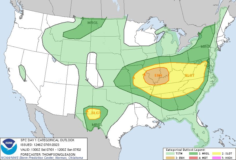 |
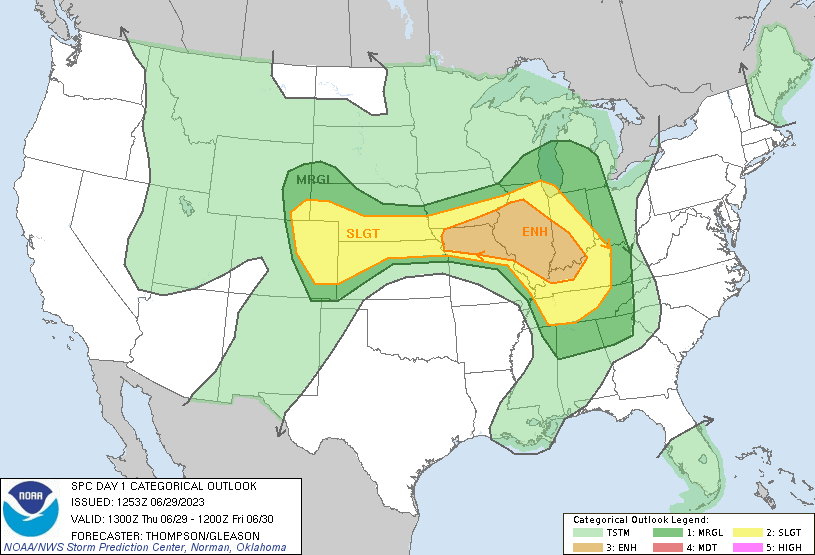
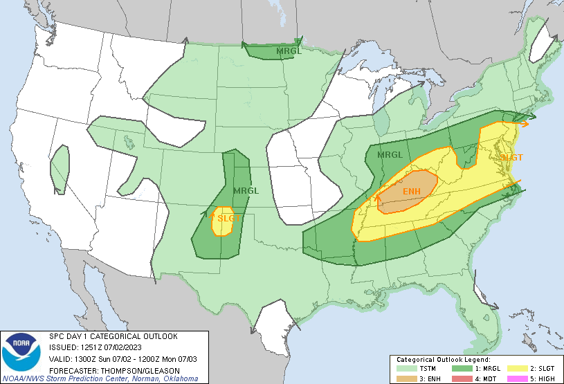
| Storm Prediction Center 13z outlook for June 29 |
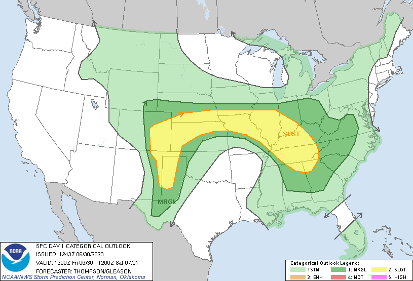
Storm Prediction Center 13z outlook for June 30 |
Storm Prediction Center 13z outlook for July 1 |
 |
 |
|
| Storm Prediction Center 13z outlook for July 2 |
During the June 29 to July 2, 2023, period, NWS Paducah issued 154 severe thunderstorm and tornado warnings for our county warning area. | During the June 29 to July 2, 2023, period, NWS Paducah received 238 reports of large hail, damaging winds, or severe wind gusts. |
 |
Media use of NWS Web News Stories is encouraged! Please acknowledge the NWS as the source of any news information accessed from this site. |
|