Overview
On July 9, 2024, the remnants of Hurricane Beryl move through the Lower Ohio Valley. Beryl's remnant circulation drew very warm and very moist air into much of the region. Combined with enhanced shear from the circulation, conditions became favorable for severe thunderstorm development. Seven tornadoes occurred during the mid-afternoon to early evening hours. The strongest tornado was an EF-3 that struck the east side of Mount Vernon, IN, causing considerable damage to a large warehouse. This EF-3 tornado was the strongest July tornado on record (since 1950) in the NWS Paducah County Warning Area. Additionally, the seven tornadoes in one day was the most tornadoes recorded on one day in the month of July on record for the NWS Paducah County Warning Area.
 |
 |
 |
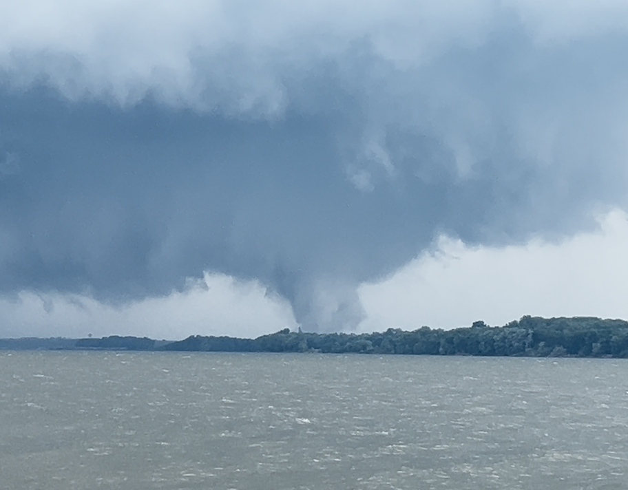
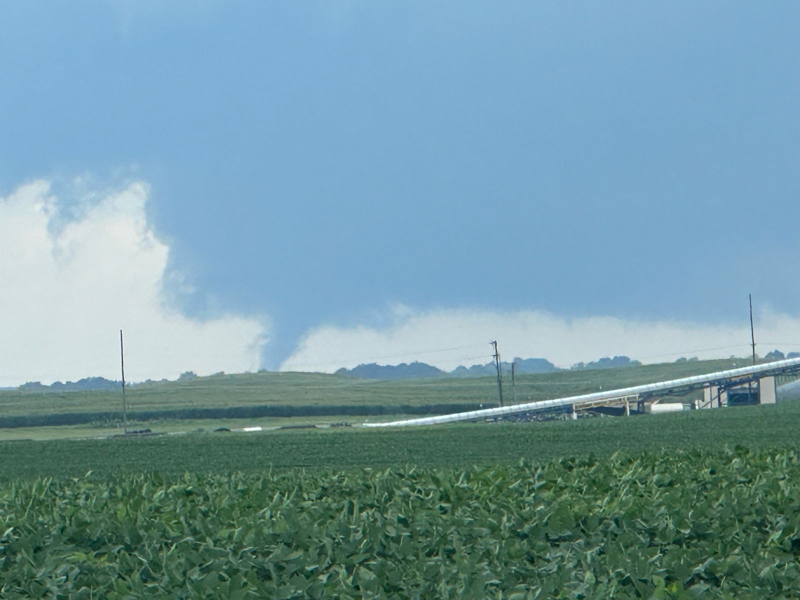
| Tornado crossing the Ohio River into Mount Vernon, IN. Credit: Zachary Jennings, Matt Reneer, and Jordan Steitler |
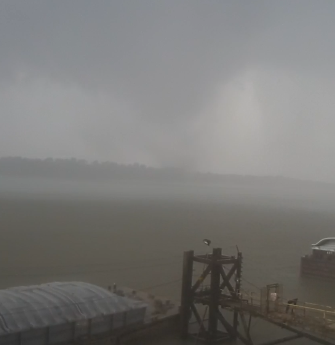
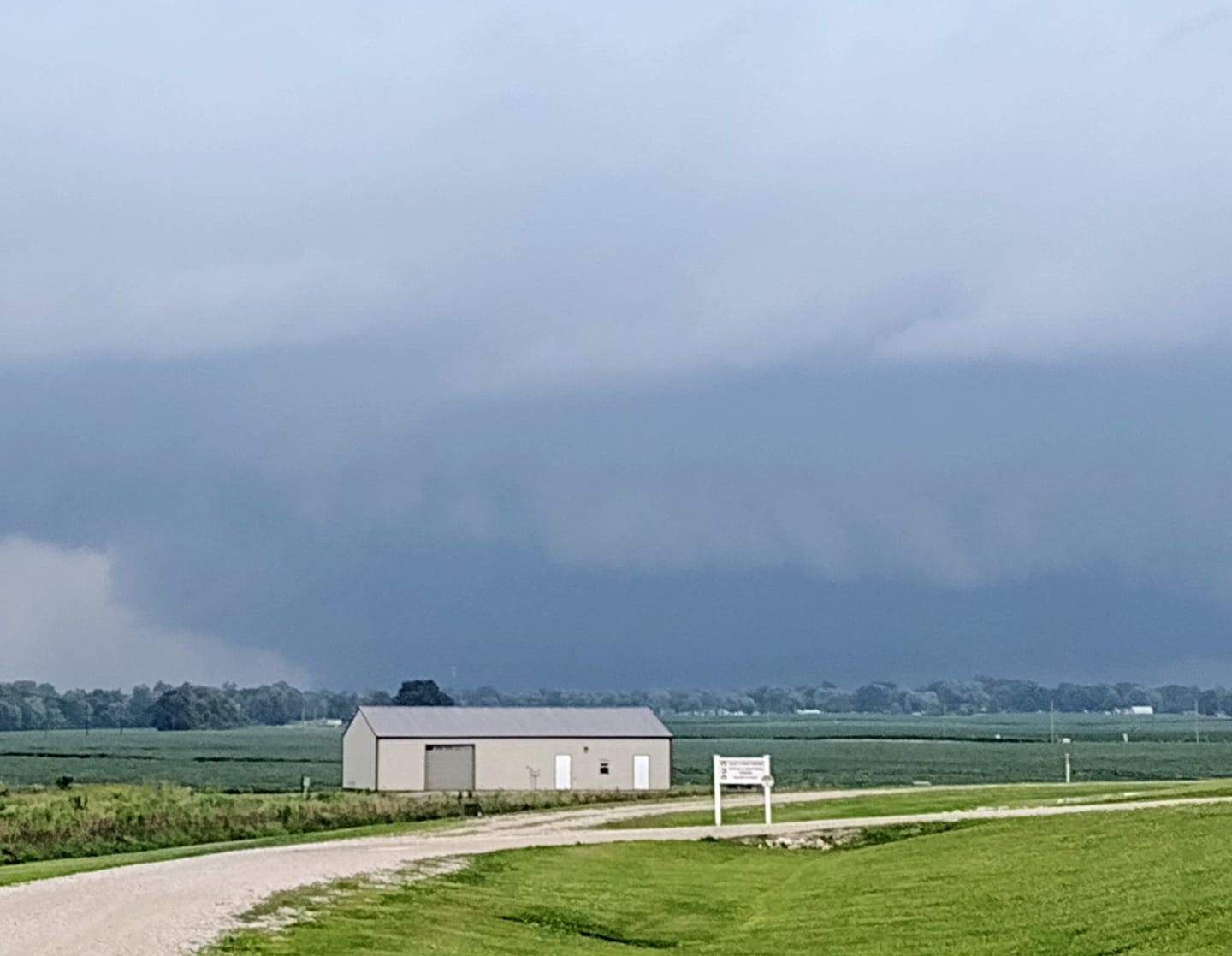
Tornado over the Ohio River at Uniontown, KY. Credit: Wesley Belt |
EF-3 tornado damage at Kenco in Mount Vernon, IN. Credit: NWS Storm Damage Survey |
Tornadoes:
|
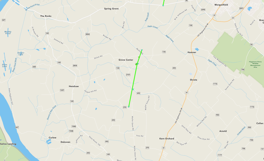
Tornado #1 - Grove Center, KY
|
||||||||||||||||
|
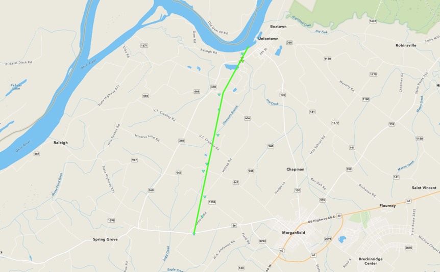
Tornado #2 - Uniontown, KY
|
||||||||||||||||
|
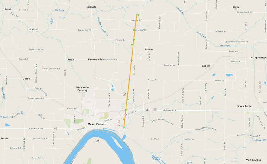
Tornado #3 - Mount Vernon, IN
|
||||||||||||||||
|
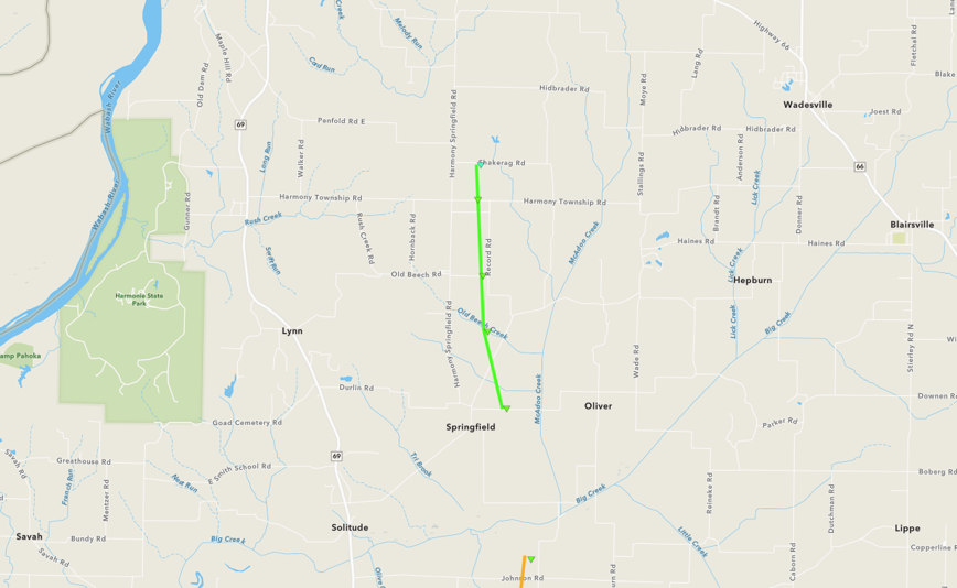
Tornado #4 - Springfield, IN
|
||||||||||||||||
|
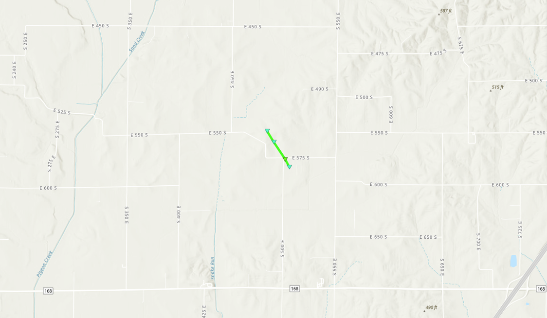
Tornado #5 - South of Francisco, IN
|
||||||||||||||||
|
Tornado #6 - Poseyville to Johnson, IN
|
||||||||||||||||
|
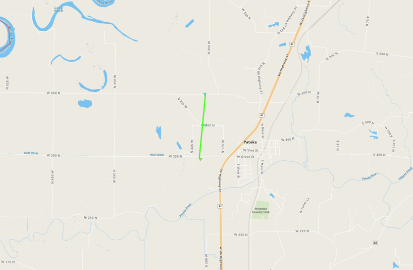
Tornado #7 - Patoka, IN
|
||||||||||||||||
The Enhanced Fujita (EF) Scale classifies tornadoes into the following categories:
| EF0 Weak 65-85 mph |
EF1 Moderate 86-110 mph |
EF2 Significant 111-135 mph |
EF3 Severe 136-165 mph |
EF4 Extreme 166-200 mph |
EF5 Catastrophic 200+ mph |
 |
|||||
Photos & Video
|
 |
|
|
| Damage to Kenco in Mount Vernon, IN. (NWS Damage Survey) |
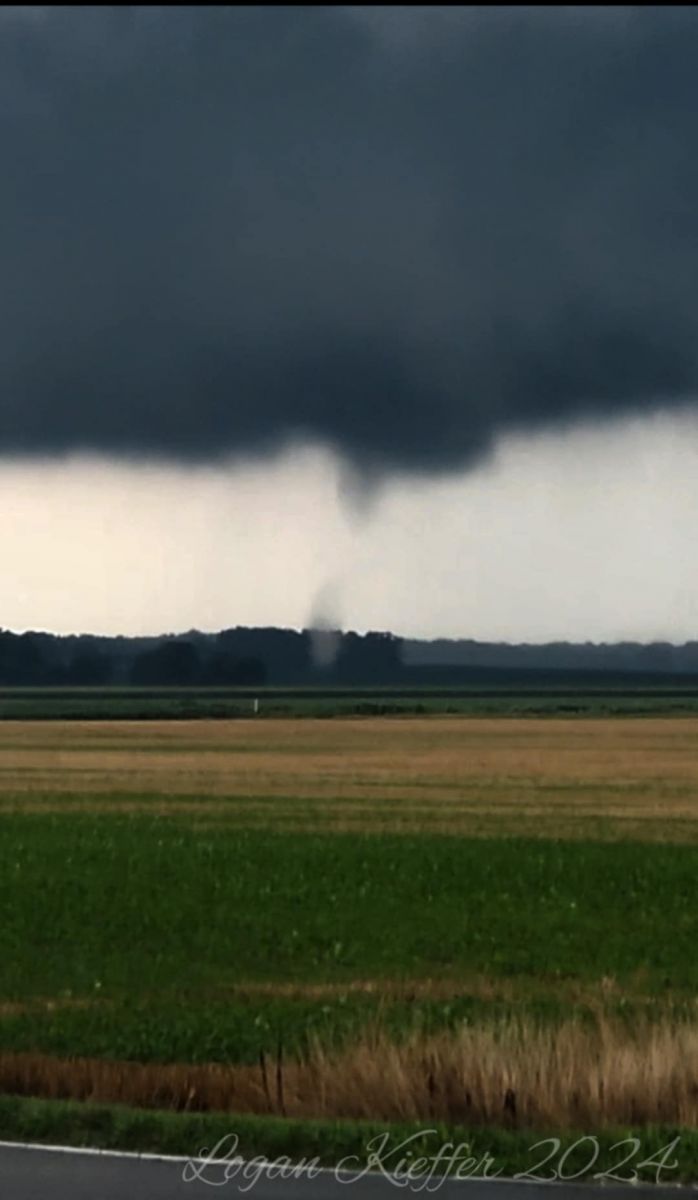
Tornado near Poseyville, IN. (Logan Kieffer and Kayden Lord) |
Tornado crossing the Ohio River into Mount Vernon, IN. (Zachary Jennings, Matt Reneer, and Jordan Steitler) |
Tornado over the Ohio River at Uniontown, KY. (Wesley Belt) |
 |
 |
 |
 |
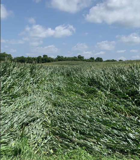
| Blown down corn by tornadic winds near Grove Center, KY. (NWS Damage Survey) |
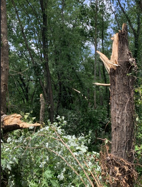
Tree damage near Uniontown, KY. (NWS Damage Survey) |
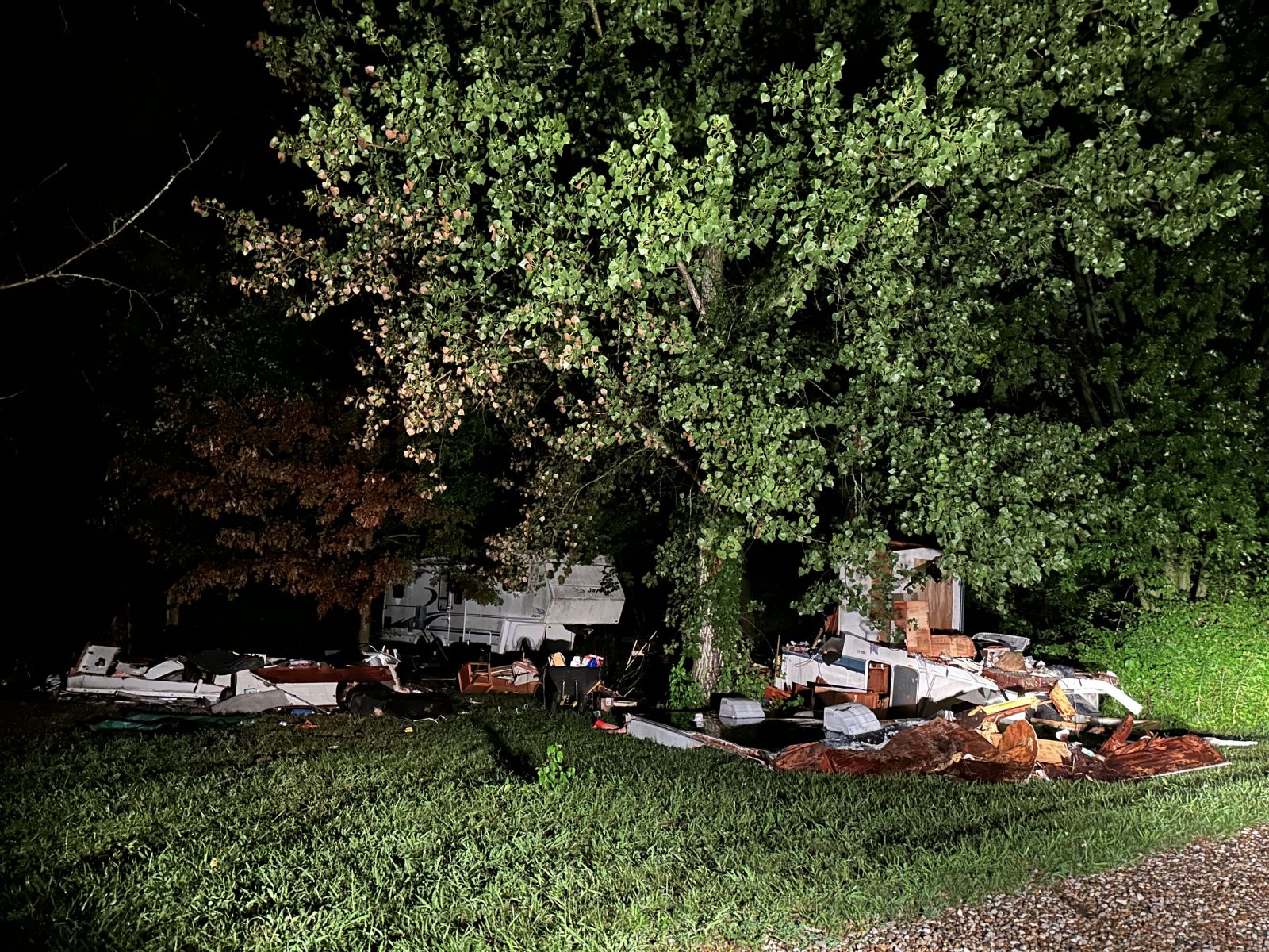
Damage to a camper near Johnson, IN. (Peyton Davis) |
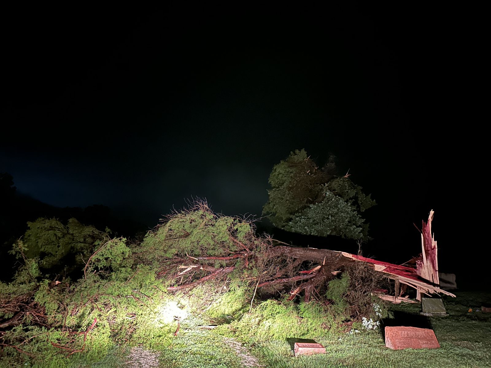
Tree damage in Maumee Cemetery near Johnson, IN. (Peyton Davis) |
 |
 |
 |
 |
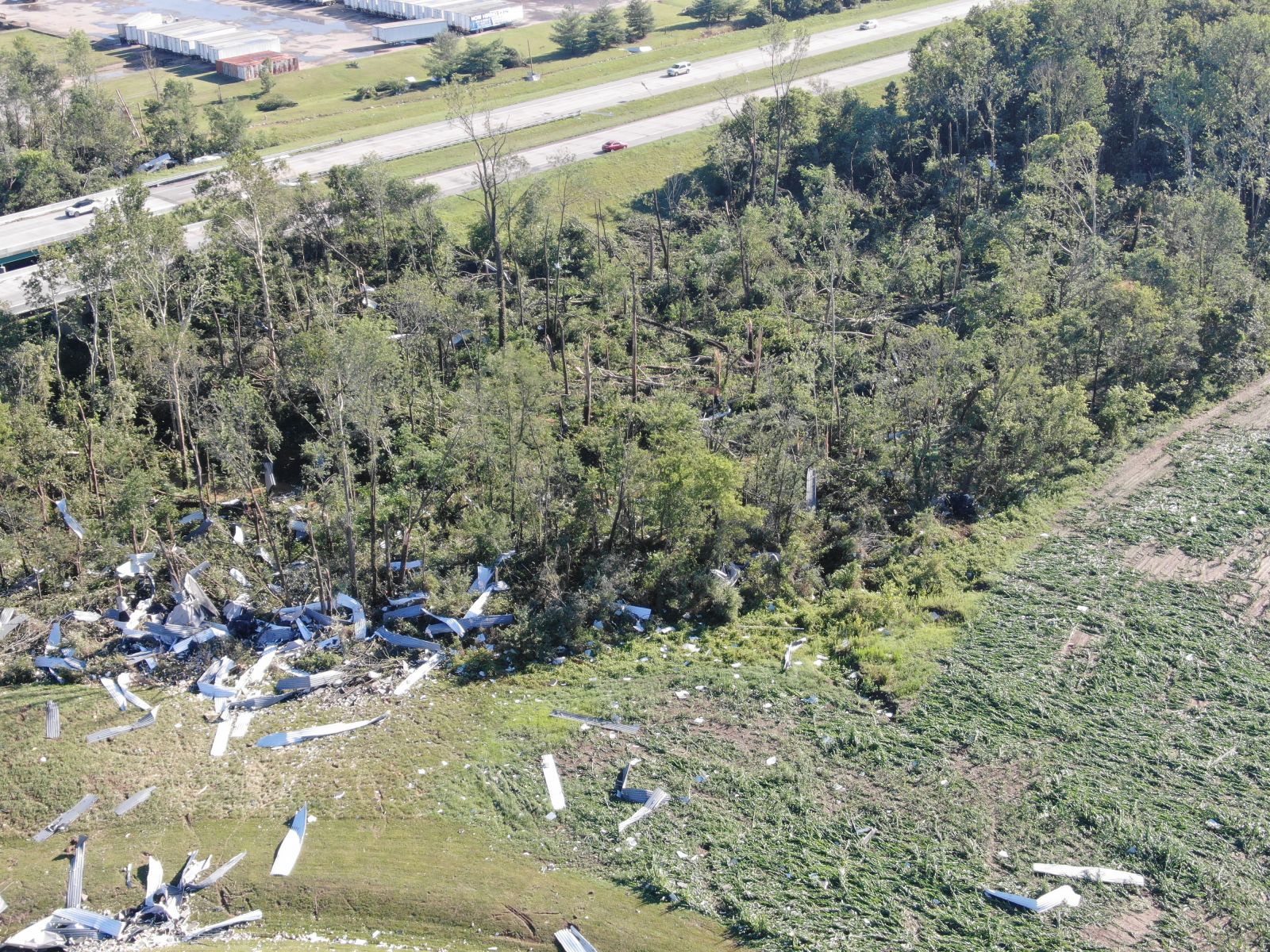
| Damage to a trees and a corn field in Mount Vernon, IN. (NWS Damage Survey) |
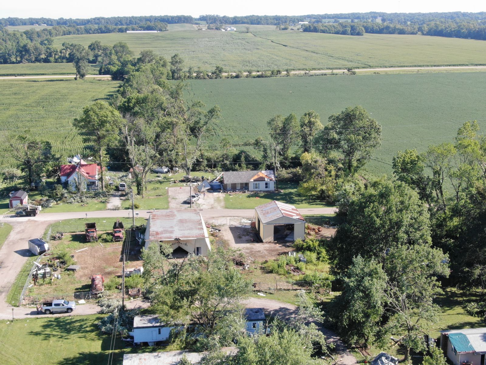
Damage to homes and outbuilding in Mount Vernon, IN. (NWS Damage Survey) |
Tornado just west of Morganfield, KY. (Mary Burke) |
View of the tornado-producing supercell as it passed through Johnson, IN. (Aaron Fryxell) |
| EF-3 tornado damage to Kenco in Mount Vernon, IN. (NWS Damage Survey) |
EF-3 tornado damage to Kenco in Mount Vernon, IN. (NWS Damage Survey) |
Radar
 |
 |
 |
 |
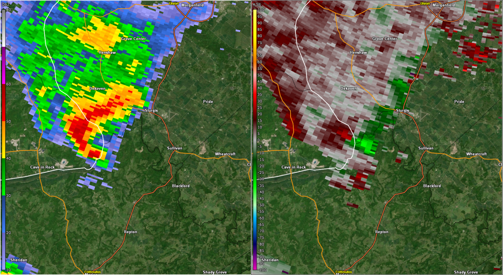
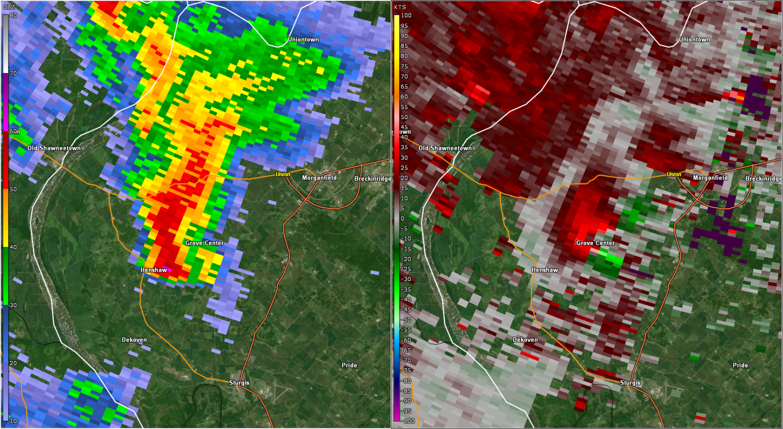
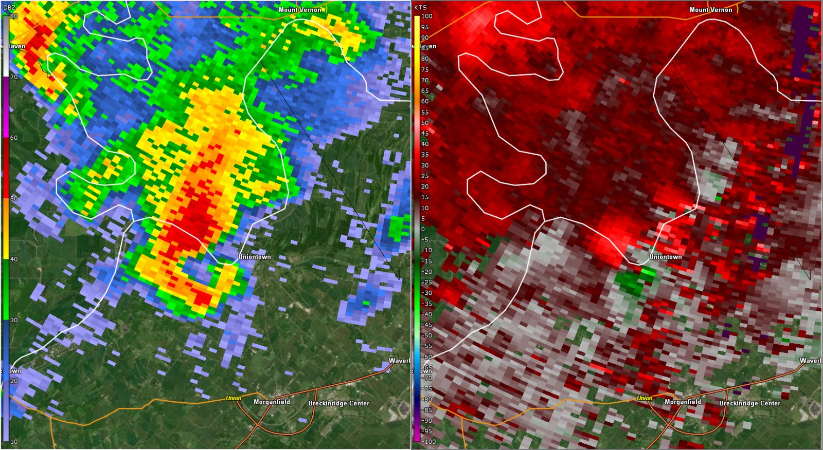
| KVWX 0.5° base reflectivity and storm relative velocity at 3:09 PM CDT centered over Sturgis, KY. | KVWX 0.5° base reflectivity and storm relative velocity at 3:31 PM CDT centered over Grove Center, KY. | KVWX 0.5° base reflectivity and storm relative velocity at 3:51 PM CDT centered over Uniontown, KY. | KVWX 0.5° base reflectivity and storm relative velocity at 4:22 PM CDT centered over Mt. Vernon, IN. |
 |
 |
 |
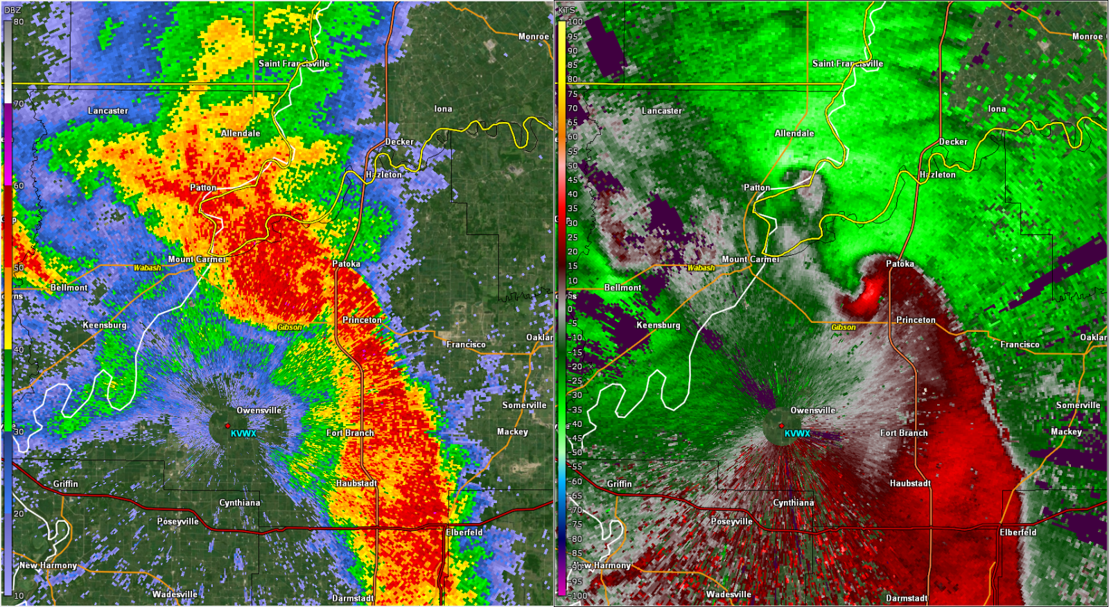 |
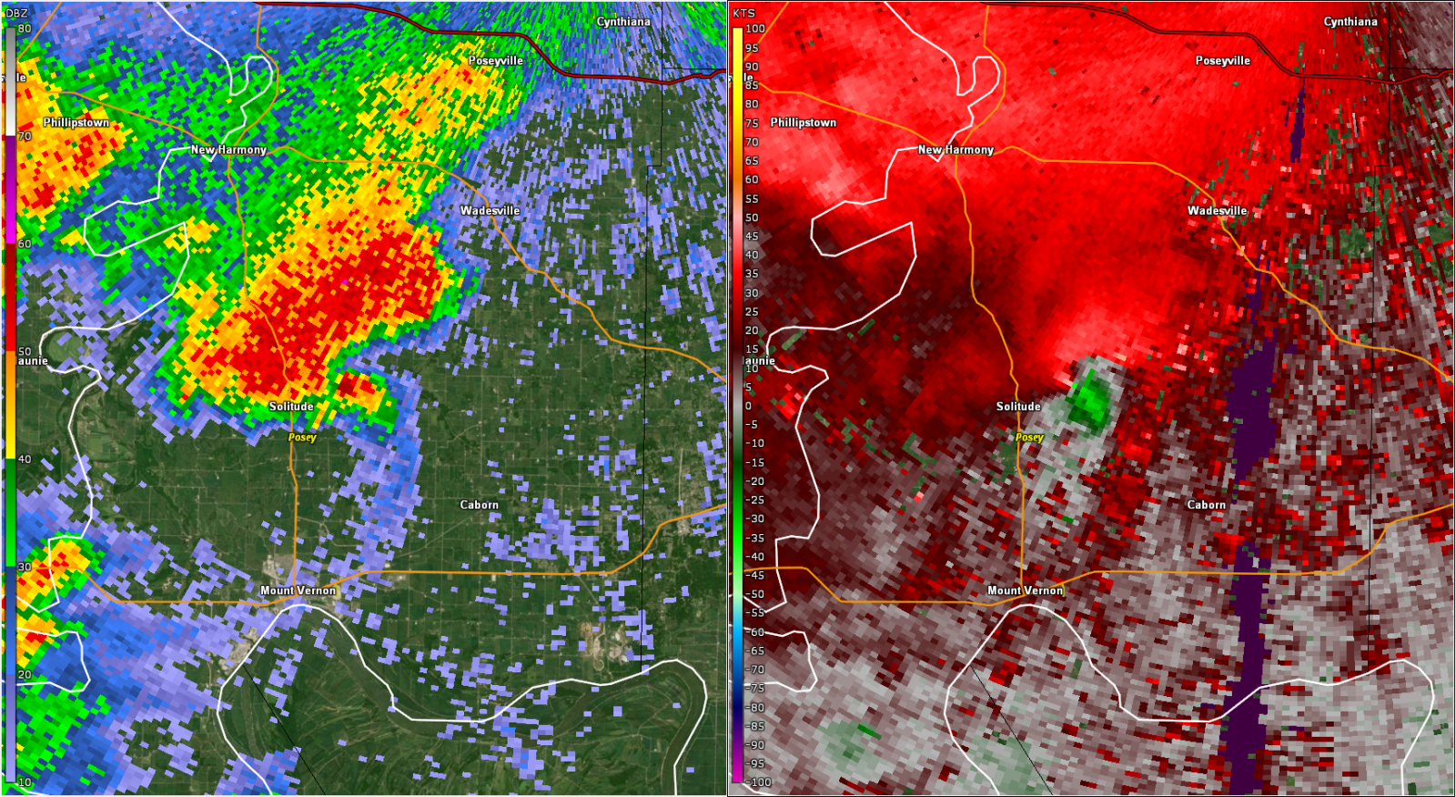
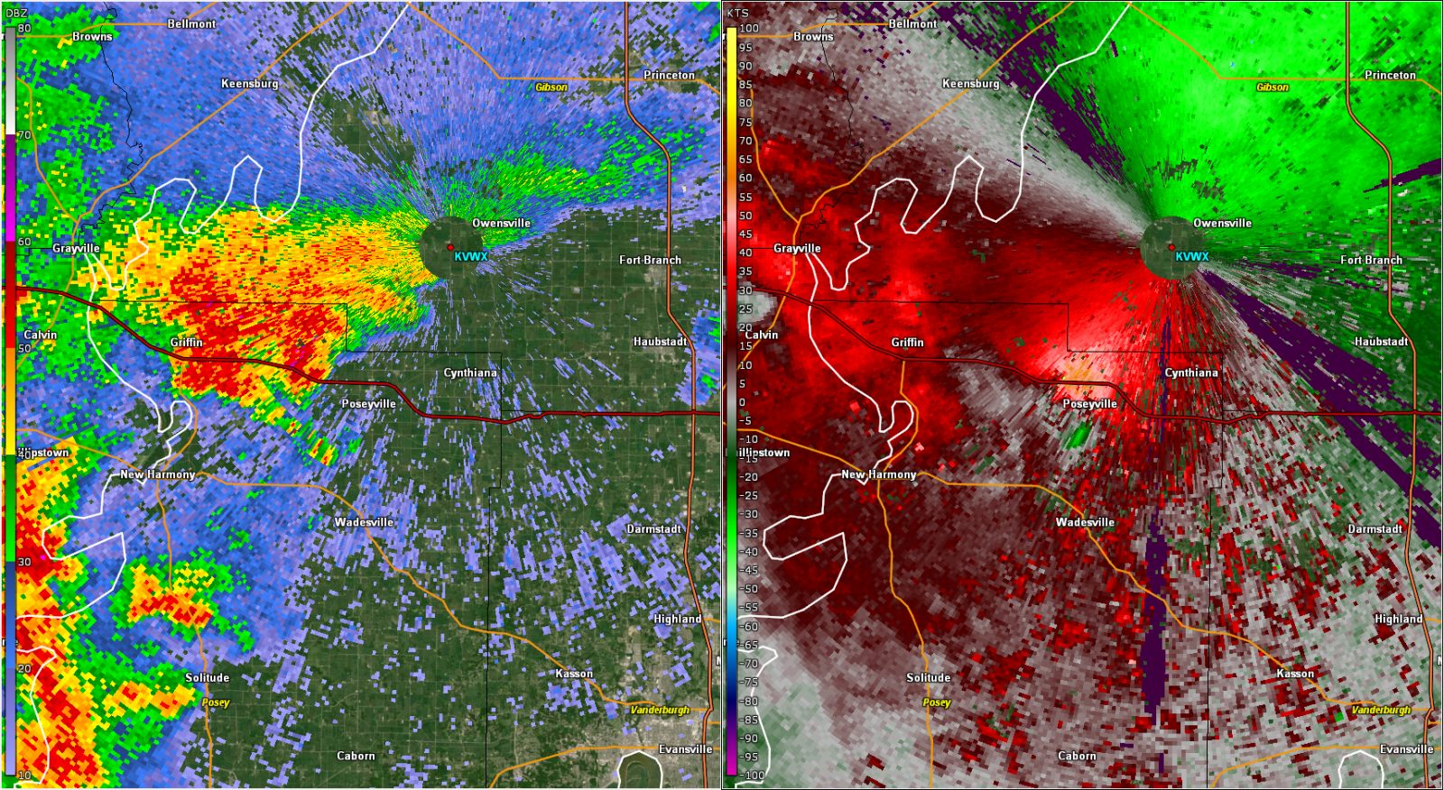
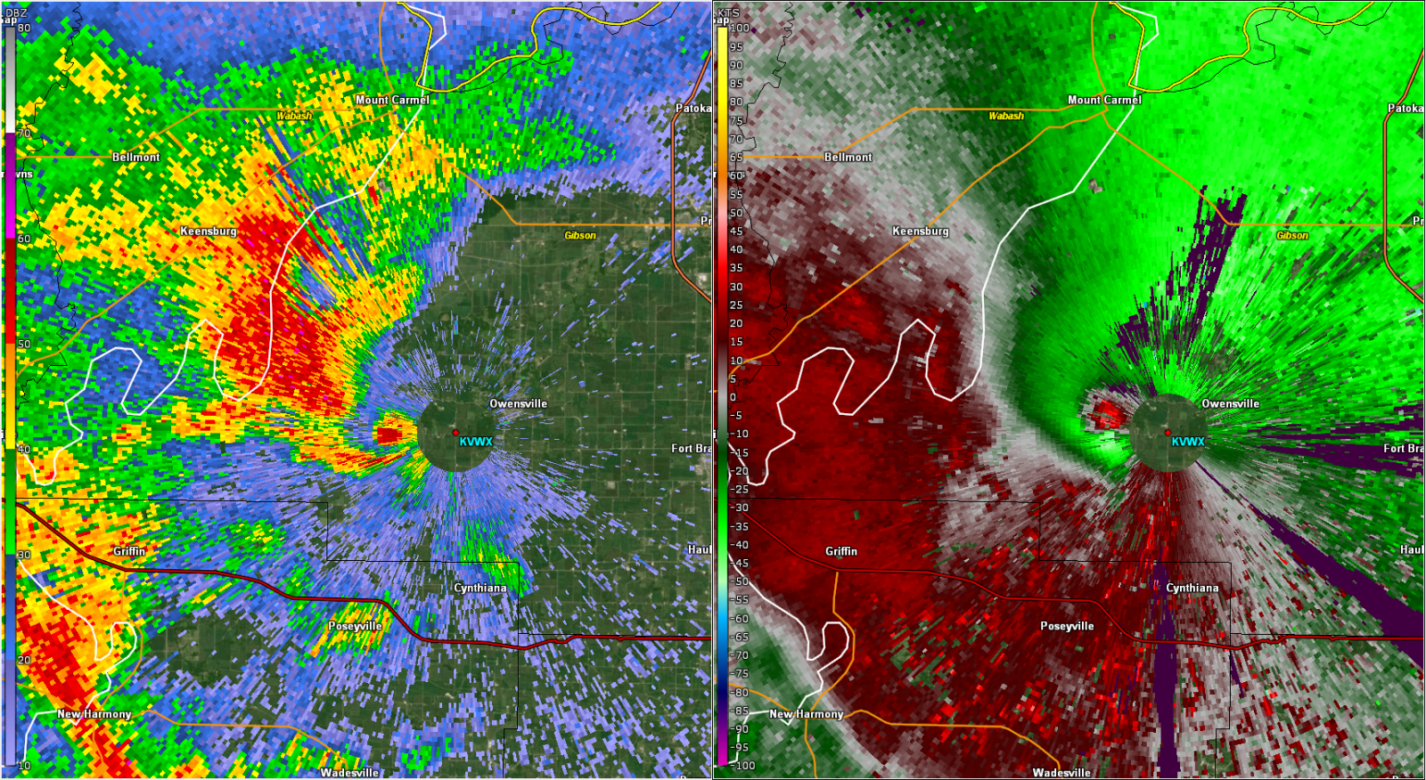
| KVWX 0.5° base reflectivity and storm relative velocity at 4:31 PM CDT centered near Solitude, IN. | KVWX 0.5° base reflectivity and storm relative velocity at 4:53 PM CDT centered over Poseyville, IN. | KVWX 0.5° base reflectivity and storm relative velocity at 5:08 PM CDT centered over Johnson, IN. | KVWX 0.5° base reflectivity and storm relative velocity at 5:47 PM CDT centered over Patoka, IN. |
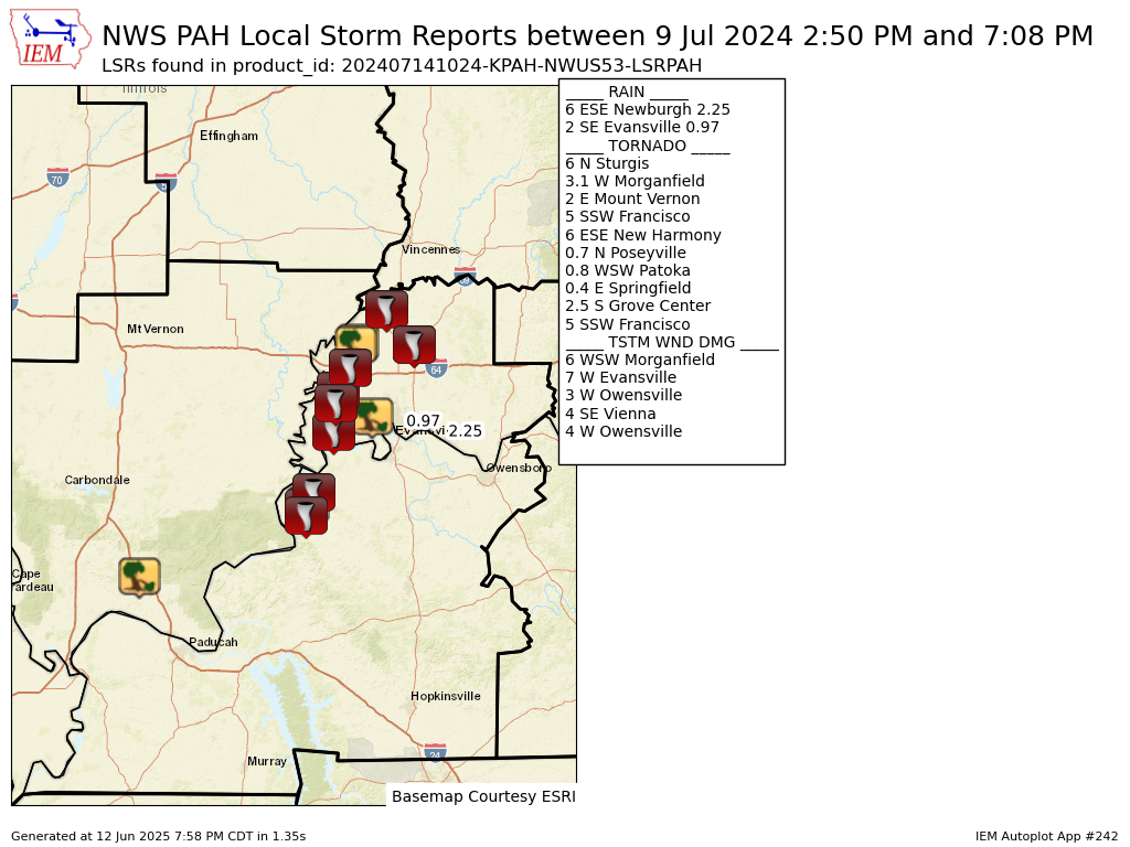
Storm Reports
Preliminary Local Storm Report...Summary
National Weather Service Paducah KY
524 AM CDT Sun Jul 14 2024

..TIME...   ...EVENT...      ...CITY LOCATION...     ...LAT.LON...
..DATE...   ....MAG....      ..COUNTY LOCATION..ST.. ...SOURCE....
            ..REMARKS..

0250 PM     Tstm Wnd Dmg     4 SE Vienna             37.36N 88.84W
07/09/2024                   Johnson            IL   Public

            Mobile home slid off the foundation and had
            areas of roofing damage. Multiple tree limbs
            blown down.

0328 PM     Tornado          2.5 S Grove Center      37.60N 88.01W
07/09/2024                   Union              KY   NWS Storm Survey

            An EF-1 Tornado touched down 2.5 miles south
            of Grove Center and lifted 1 mile northeast
            of Grove Center. The estimated peak wind was
            105 mph. The path length was 3.22 miles and
            the maximum path width was 150 yards. Two
            homes had minor to moderate roof damage.
            Several large trees were uprooted or
            snapped. Crops were severely damaged.

0331 PM     Tornado          6 N Sturgis             37.63N 88.01W
07/09/2024                   Union              KY   Emergency Mngr

            Corrects previous tornado report from 6 N
            Sturgis. Warned Tornado confirmed on the
            ground.

0331 PM     Tstm Wnd Dmg     6 WSW Morganfield       37.64N 88.00W
07/09/2024                   Union              KY   Emergency Mngr

            Tornado damage reported, power lines down,
            damage to house.

0340 PM     Tornado          3.1 W Morganfield       37.69N 87.97W
07/09/2024                   Union              KY   NWS Storm Survey

            An EF-1 Tornado touched down 3.1 miles west
            of Morganfield and lifted 0.5 miles west of
            Uniontown. The estimated peak wind was 100
            mph. The path length was 6.34 miles and the
            maximum path width was 150 yards. Several
            large trees were uprooted or snapped and
            there was significant damage to crops.

0418 PM     Tornado          2 E Mount Vernon        37.93N 87.87W
07/09/2024                   Posey              IN   NWS Storm Survey

            An EF-3 tornado touched down 2 miles east of
            Mt Vernon and lifted 2.4 miles east
            southeast of Solitude in Posey County. The
            estimated peak wind was 140 mph. The path
            length was 5.85 miles and the maximum path
            width was 300 yards. The worst damage
            occurred to the Kenco Facility where roughly
            half of the roof was removed and several
            large segments of the outer walls collapsed.
            Semi trailers and train cars were overturned
            near Old Highway 62. One manufactured home
            had its roof blown off and walls collapsed.
            A few other homes and farm buildings had
            roof damage. Tree and crop damage occurred
            all along the path.

0421 PM     Tstm Wnd Dmg     7 W Evansville          37.99N 87.68W
07/09/2024                   Vanderburgh        IN   Trained Spotter

            power outage reported.

0425 PM     Tstm Wnd Dmg     3 W Owensville          38.28N 87.75W
07/09/2024                   Gibson             IN   Public

            pole barn knocked completely down.

0432 PM     Tornado          0.4 E Springfield       38.04N 87.86W
07/09/2024                   Posey              IN   NWS Storm Survey

            An EF-1 Tornado touched down 0.4 miles east
            of Springfield and lifted 4.6 miles west
            southwest of Wadesville in Posey County. The
            estimated peak wind was 105 mph. The path
            length was 3.29 miles and the maximum path
            width was 300 yards. One power pole was bent
            and numerous trees were damaged.

0437 PM     Tornado          5 SSW Francisco         38.27N 87.47W
07/09/2024                   Gibson             IN   Emergency Mngr

            Corrects previous tornado report from 5 SSW
            Francisco. Delayed Report. Brief tornado
            touched down just west of Mackey, IN. Damage
            reported to a home and crops.

0440 PM     Tornado          6 ESE New Harmony       38.09N 87.85W
07/09/2024                   Posey              IN   Trained Spotter

            confirmed tornado on the ground.

0451 PM     Tornado          0.7 N Poseyville        38.18N 87.79W
07/09/2024                   Posey              IN   NWS Storm Survey

            An EF-2 Tornado touched down 0.7 miles north
            of Poseyville and lifted 1.3 miles north of
            Johnson in Gibson County. The estimated peak
            wind was 120 mph. The path length was 8.38
            miles and the maximum path width was 400
            yards. One manufactured home and several
            farm and outbuildings were collapsed. A
            power pole was broken. Crop and tree damage
            occurred all along the path.

0515 PM     Tstm Wnd Dmg     4 W Owensville          38.27N 87.76W
07/09/2024                   Gibson             IN   Public

            Report from mPING: Trees uprooted or
            snapped; Roof blown off.

0550 PM     Tornado          0.8 WSW Patoka          38.41N 87.61W
07/09/2024                   Gibson             IN   NWS Storm Survey

            An EF-1 touched down 0.8 miles west
            southwest of Patoka and lifted 1.1 miles
            northwest of Patoka. The estimated peak wind
            was 100 mph. The path length was 1.06 miles
            and the maximum path width was 25 yards. One
            power pole was leaning and there was crop
            and tree limb damage.

0629 PM     Rain             6 ESE Newburgh          37.92N 87.30W
07/09/2024  E2.25 Inch       Warrick            IN   Trained Spotter

            rainfall estimated amount reported.

0708 PM     Rain             2 SE Evansville         37.96N 87.51W
07/09/2024  M0.97 Inch       Vanderburgh        IN   Trained Spotter

            storm total rain amount.
Environment
 |
 |
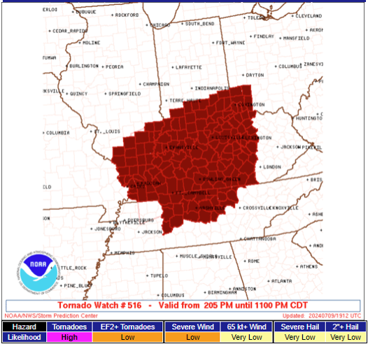 |
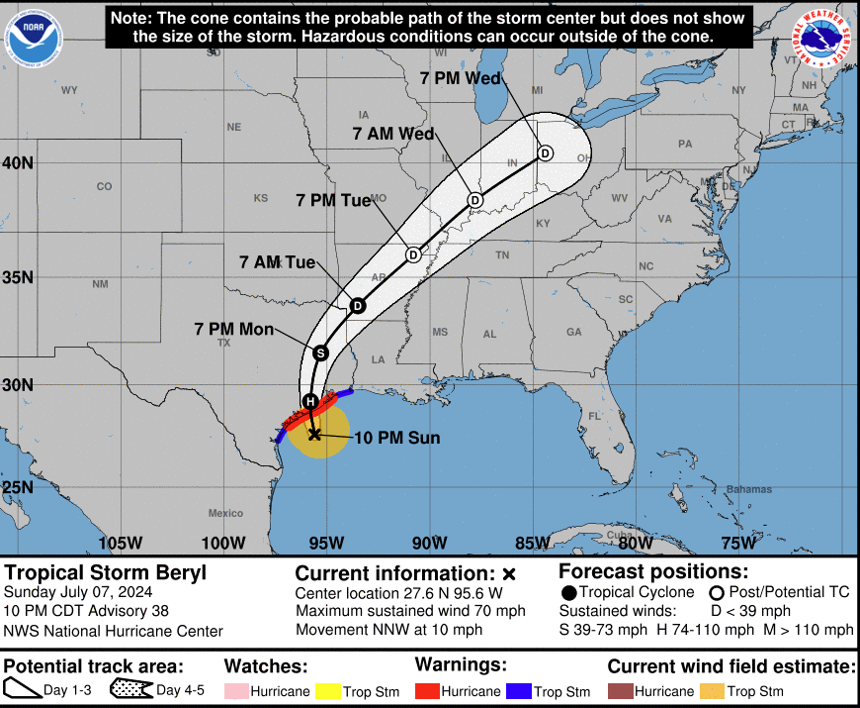
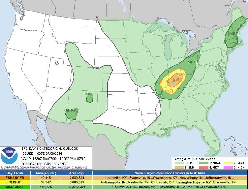
| Figure 1: National Hurricane Center advisory for Beryl issued July 7, 2024. | Figure 2: Storm Prediction Center Day 1 severe weather outlook for July 9, 2024. | Figure 3: Tornado Watch #516 issued for much of the Lower Ohio Valley on the afternoon July 9, 2024. |
 |
Media use of NWS Web News Stories is encouraged! Please acknowledge the NWS as the source of any news information accessed from this site. |
|