Overview
A potent storm system pushed a cold front into our region during the afternoon and evening of April 13th. Ahead of this front, an intense line of thunderstorms formed across Arkansas into far southeast Missouri and pivoted east/northeast into west Kentucky. Most of the damage with these storms was confined to the southern two tiers of counties in western Kentucky. A more unstable airmass developed in this region during the mid to late afternoon, but struggled to make much further northward progress across the rest of our area. Unfortunately, some of the worst wind damage occurred in several of the communities impacted by the December 10, 2021 EF-4 tornado. There were 6 confirmed tornadoes across western Kentucky including an EF-1 that hit just north of Mayfield.Tornadoes:
|
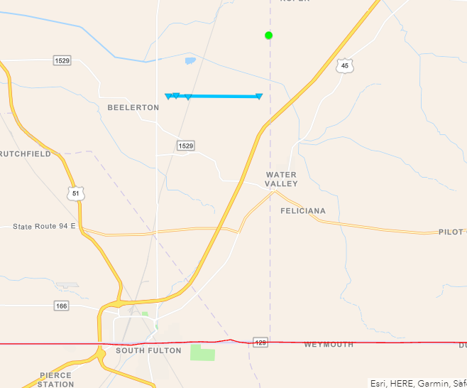
Tornado #1 - Water Valley, Kentucky
Track Map

|
||||||||||||||||
|
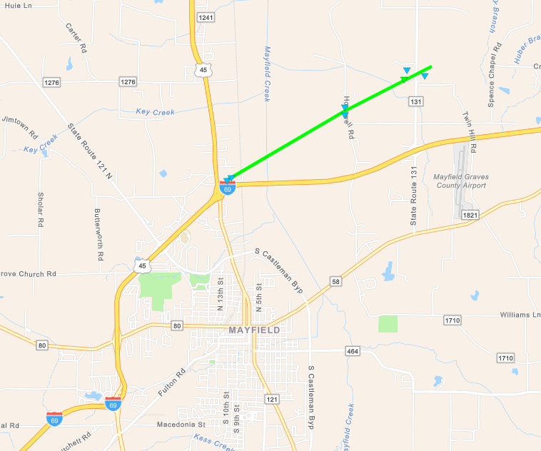
Tornado #2 - Mayfield, Kentucky
Track Map
|
||||||||||||||||
|
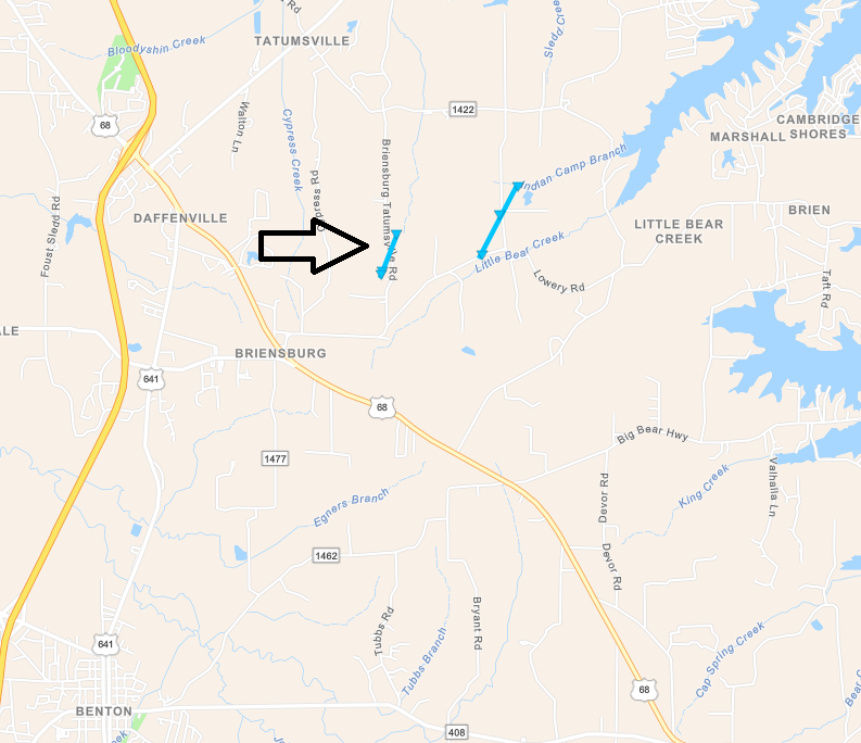
Tornado #3 - NE Benton, Kentucky
Track Map
|
||||||||||||||||
|
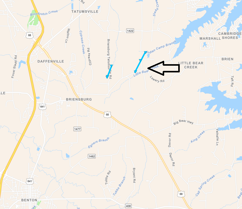
Tornado #4 - NE Benton, Kentucky #2
Track Map
|
||||||||||||||||
|
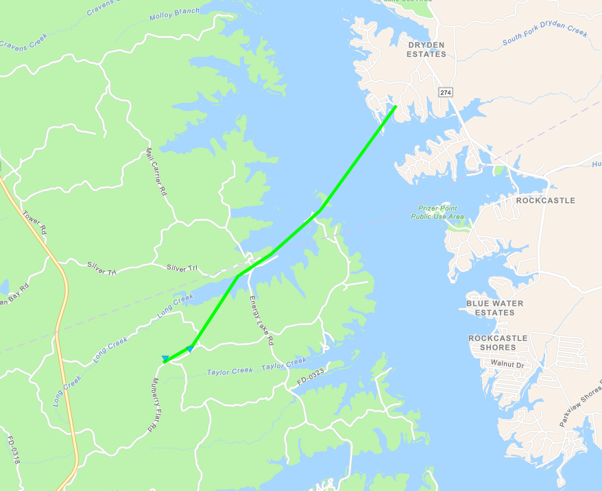
Tornado #5 - LBL Kentucky
Track Map
|
||||||||||||||||
|
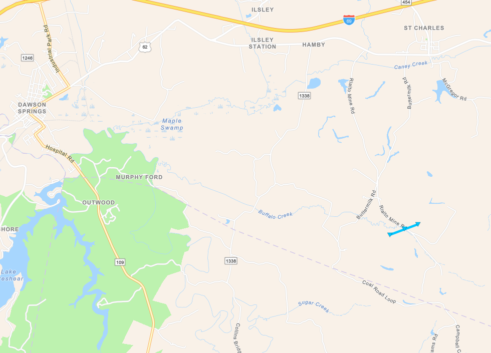
Tornado #6 - Southeast of Dawson Springs, KY
Track Map
|
||||||||||||||||
The Enhanced Fujita (EF) Scale classifies tornadoes into the following categories:
| EF0 Weak 65-85 mph |
EF1 Moderate 86-110 mph |
EF2 Significant 111-135 mph |
EF3 Severe 136-165 mph |
EF4 Extreme 166-200 mph |
EF5 Catastrophic 200+ mph |
 |
|||||
Photos
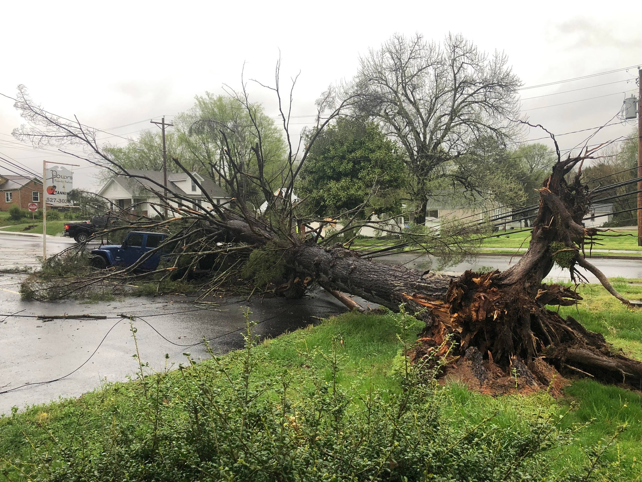 |
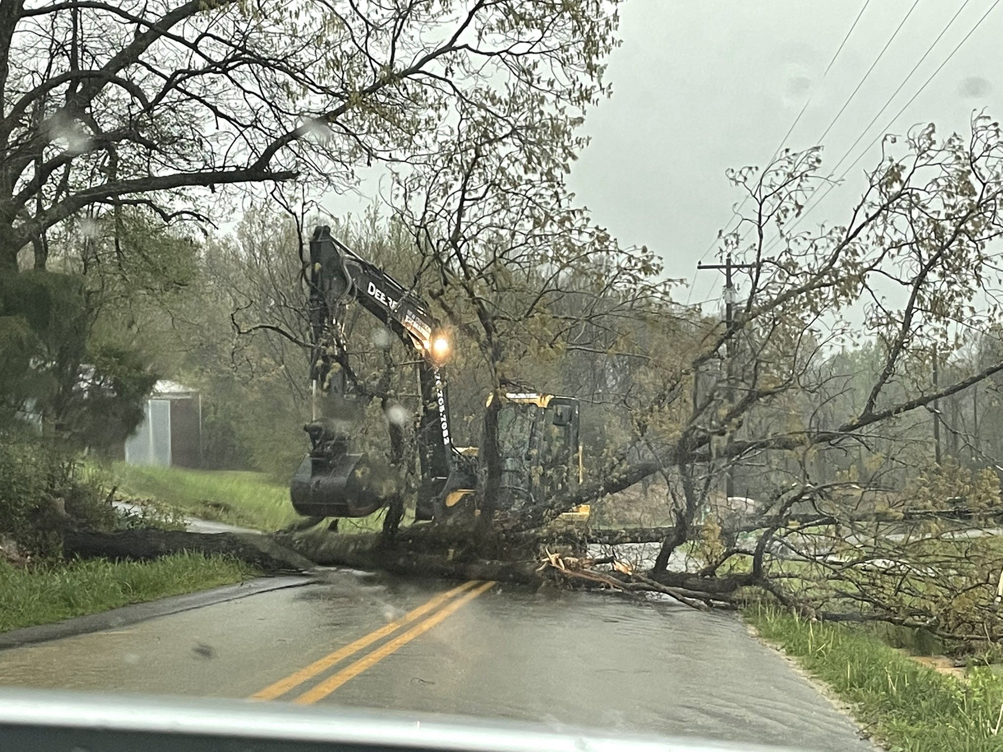 |
 |
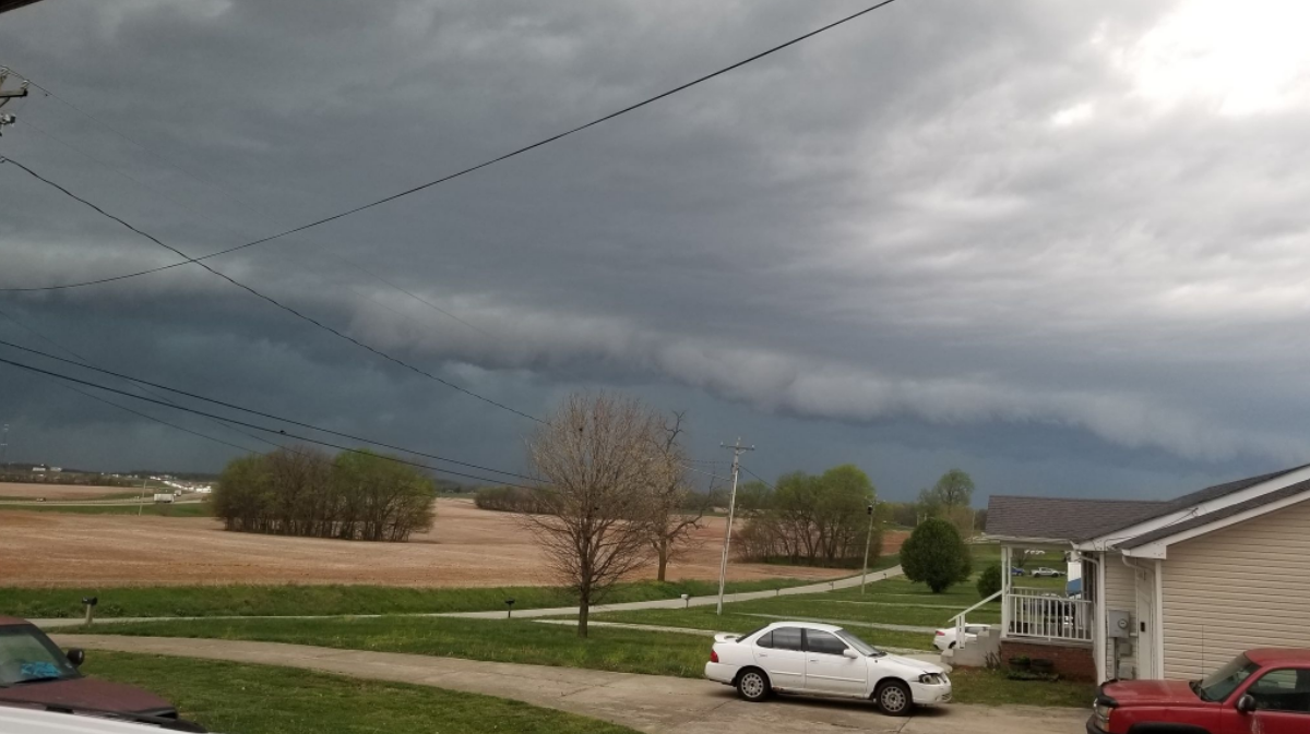 |
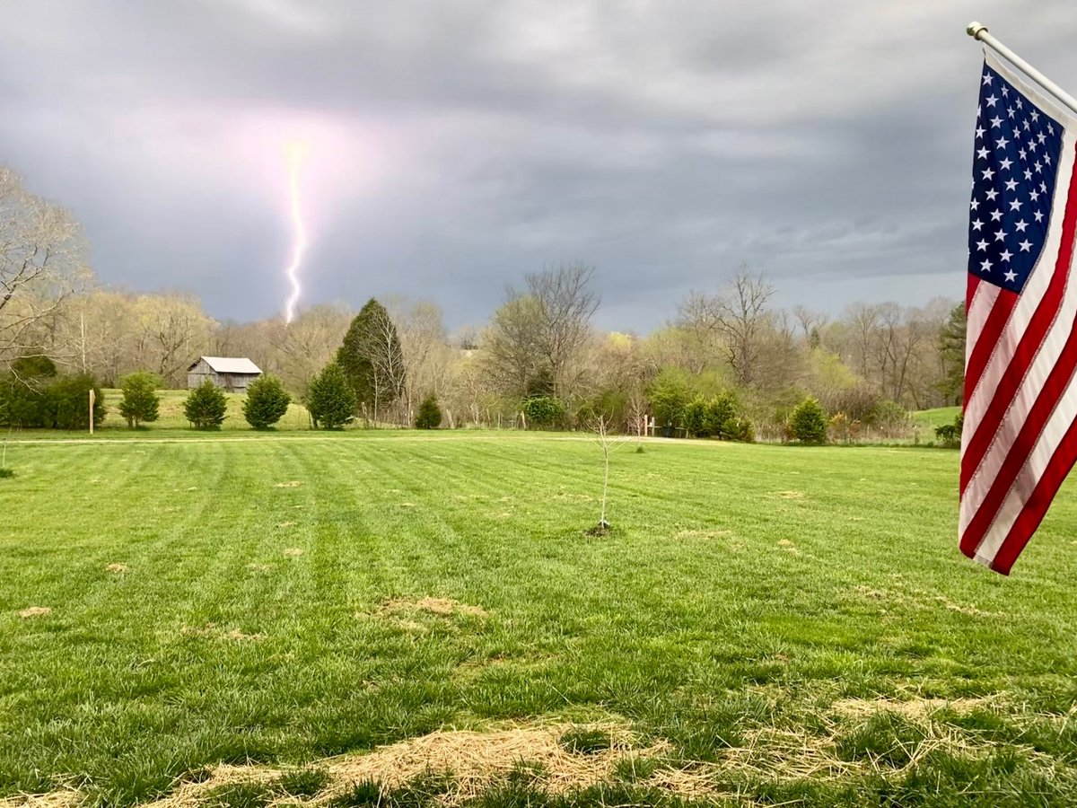
| Damage in Benton, KY via John Temple | Damage east of Mayfield, KY via James T | Lightning in Muhlenberg County KY via Patrick Jeter | Shelf cloud in Oak Grove, KY via Lesa Dussault |
Radar
Click here for a radar loop of this event.
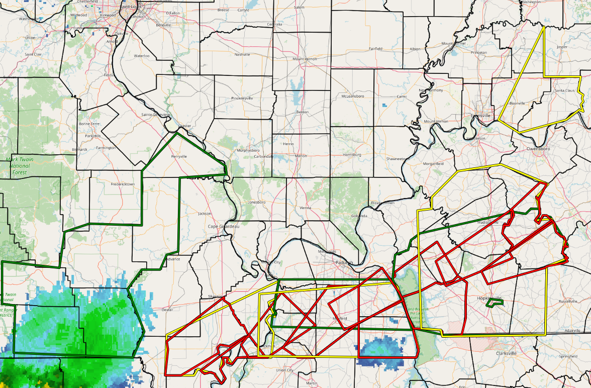
The graphic below displays all Severe Thunderstorm, Tornado, and Flash Flood Warnings issued during the event.
Storm Reports
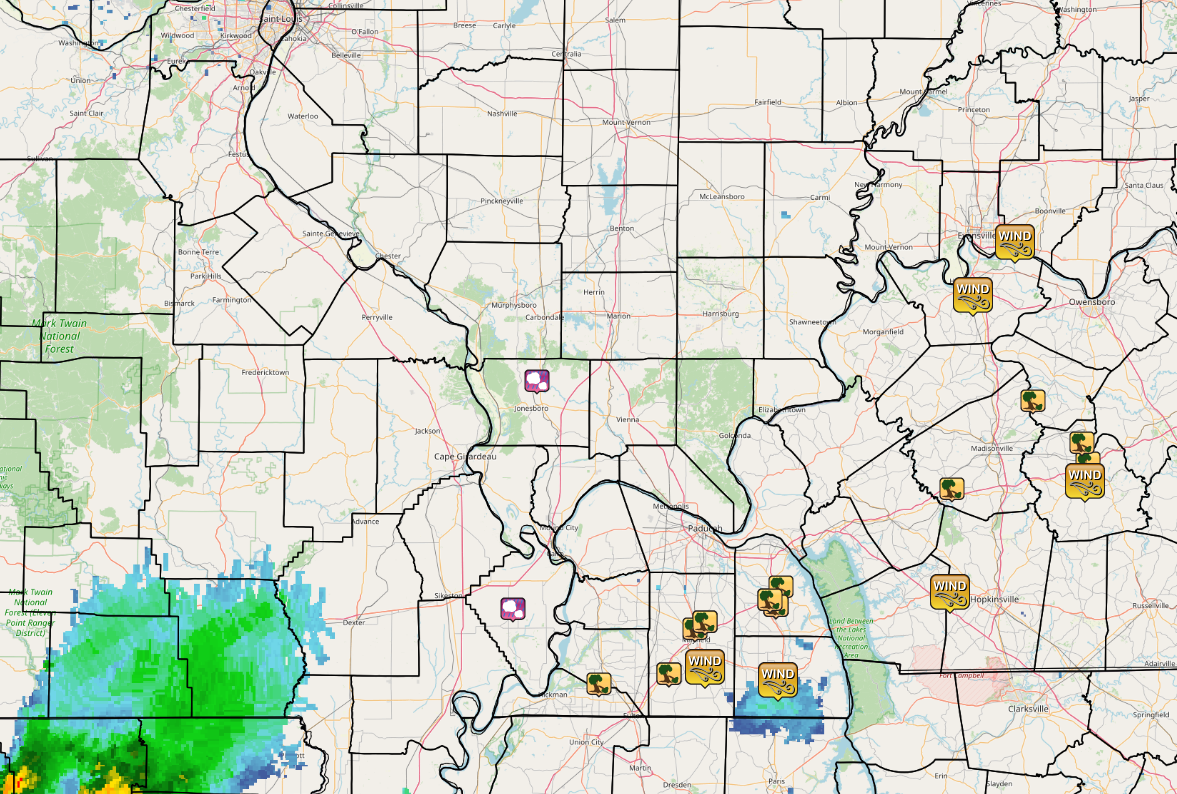 |
| Graphic above displays all Local Storm Reports issued during this event for the NWS Paducah area. |
PRELIMINARY LOCAL STORM REPORT...SUMMARY
NATIONAL WEATHER SERVICE PADUCAH KY
1051 PM CDT THU APR 14 2022

..TIME...   ...EVENT...      ...CITY LOCATION...     ...LAT.LON...
..DATE...   ....MAG....      ..COUNTY LOCATION..ST.. ...SOURCE....
            ..REMARKS..

0605 PM     TSTM WND GST     2 SE POWDERLY           37.22N 87.14W
04/13/2022  M49 MPH          MUHLENBERG         KY   MESONET


0558 PM     TSTM WND DMG     BREMEN                  37.36N 87.22W
04/13/2022                   MUHLENBERG         KY   EMERGENCY MNGR

            TREE FELL ON A TRAILER IN BREMEN. TIME
            ESTIMATED FROM RADAR.

0552 PM     TSTM WND DMG     SOUTH CARROLLTON        37.34N 87.15W
04/13/2022                   MUHLENBERG         KY   PUBLIC

            REPORT FROM MPING: 1-INCH TREE LIMBS BROKEN;
            SHINGLES BLOWN OFF.

0552 PM     TSTM WND DMG     1 SSW CENTRAL CITY      37.28N 87.13W
04/13/2022                   MUHLENBERG         KY   PUBLIC

            REPORT FROM MPING: 1-INCH TREE LIMBS BROKEN;
            SHINGLES BLOWN OFF.

0550 PM     TSTM WND DMG     5 NW SACRAMENTO         37.47N 87.34W
04/13/2022                   MCLEAN             KY   PUBLIC

            REPORT FROM MPING: 3-INCH TREE LIMBS BROKEN;
            POWER POLES BROKEN.

0530 PM     TSTM WND DMG     HOPKINSVILLE            36.86N 87.49W
04/13/2022                   CHRISTIAN          KY   EMERGENCY MNGR

            TREES DOWN ON VIRGINIA STREET IN
            HOPKINSVILLE. TIME ESTIMATED FROM RADAR.

0525 PM     TSTM WND DMG     4 W HOPKINSVILLE        36.86N 87.56W
04/13/2022                   CHRISTIAN          KY   EMERGENCY MNGR

            TREES DOWN NEAR INTERSECTION OF HIGHWAYS 272
            AND 164 WEST OF HOPKINSVILLE. TIME ESTIMATED
            FROM RADAR.

0525 PM     TSTM WND DMG     3 NE DAWSON SPRINGS     37.20N 87.65W
04/13/2022                   HOPKINS            KY   BROADCAST MEDIA

            SEVERAL TREES DOWN AND SOME CONSTRUCTION
            DEBRIS ON BOTH SIDES OF HIGHWAY.

0523 PM     TSTM WND DMG     SAINT CHARLES           37.19N 87.56W
04/13/2022                   HOPKINS            KY   EMERGENCY MNGR

            TREES DOWN ALONG HIGHWAY 454 IN ST. CHARLES.
            TIME ESTIMATED FROM RADAR.

0520 PM     TSTM WND GST     GRACEY                  36.88N 87.66W
04/13/2022  M72 MPH          CHRISTIAN          KY   EMERGENCY MNGR


0518 PM     TSTM WND DMG     3 SSE GRACEY            36.84N 87.64W
04/13/2022                   CHRISTIAN          KY   EMERGENCY MNGR

            ROOF PEELED BACK ON A MOBILE HOME ALONG
            GRACEY-HERNDON ROAD. TIME ESTIMATED FROM
            RADAR.

0517 PM     TSTM WND GST     NEWBURGH                37.95N 87.41W
04/13/2022  M50 MPH          WARRICK            IN   TRAINED SPOTTER

            3 INCH TREE BRANCHES BROKEN.

0514 PM     TSTM WND GST     3 SSE HENDERSON         37.79N 87.57W
04/13/2022  M47 MPH          HENDERSON          KY   MESONET

            KY MESONET WIND GUST 47.8 MPH.

0453 PM     TORNADO          5 NNW FARIDEALING       36.91N 88.29W
04/13/2022                   MARSHALL           KY   NWS STORM SURVEY

            EF-0 TORNADO STARTED 5 NE BENTON AT 453 PM
            AND LIFTED 5.7 NE BENTON AT 454 PM. PATH
            LENGTH 0.7 MILES. PATH WIDTH 25 YARDS. PEAK
            WIND 85 MPH. SIDING DAMAGE TO HOME. PORCH
            ROOF DECKING LIFTED. CHICKEN COOP DESTROYED
            BY PART OF LOFTED BARN ROOF. TREE DAMAGE.

0451 PM     TORNADO          4 WSW ROCKCASTLE        36.88N 88.06W
04/13/2022                   TRIGG              KY   NWS STORM SURVEY

            EF-1 TORNADO STARTED 5.8 WSW ROCKCASTLE AT
            451 PM CROSSED FROM TRIGG INTO LYON COUNTY
            AND LIFTED 0.9 SW DRYDEN ESTATES AT 456 PM.
            PATH LENGTH 4.75 MILES. PATH WIDTH 150
            YARDS. PEAK WIND 95 MPH. MANY TREE LIMBS
            DOWNED. SEVERAL LARGE TREES UPROOTED. A FEW
            TREES SNAPPED. DAMAGE WITHIN LAND BETWEEN
            THE LAKES.

0450 PM     TORNADO          5 NE BENTON             36.91N 88.31W
04/13/2022                   MARSHALL           KY   NWS STORM SURVEY

            EF-0 TORNADO STARTED 4.4 NE BENTON AT 450 PM
            AND LIFTED 4.8 NE BENTON AT 451 PM. PATH
            LENGTH 0.4 MILES. PATH WIDTH 25 YARDS. PEAK
            WIND 70 MPH. ROOF OFF OUTBUILDING. SHINGLE
            DAMAGE TO HOME. TREE DAMAGE.

0442 PM     TSTM WND DMG     5 NE BENTON             36.90N 88.31W
04/13/2022                   MARSHALL           KY   BROADCAST MEDIA

            HOUSE DAMAGED WITH ROOF TORN OFF HOME ON
            BRIENSBURG-TATUMSVILLE ROAD SOUTHEAST OF
            DRAFFENVILLE KY.

0439 PM     TSTM WND GST     MURRAY                  36.61N 88.32W
04/13/2022  M62 MPH          CALLOWAY           KY   PUBLIC


0438 PM     TSTM WND GST     SEDALIA                 36.65N 88.60W
04/13/2022  M68 MPH          GRAVES             KY   MESONET

            MEASURED 68.8 MPH WIND MESONET.

0437 PM     TSTM WND DMG     2 ESE BENTON            36.84N 88.33W
04/13/2022                   MARSHALL           KY   EMERGENCY MNGR

            CORRECTED TIME FOR PREVIOUS TSTM WND DMG
            REPORT FROM 2 ESE BENTON. TREE DOWN ON HOUSE
            AND POWER LINES NEAR JOHNSTON RD. BENTON, KY
            ALSO POWER LINE AND TREE DOWN ON MAIN ST. IN
            BENTON.

0435 PM     TSTM WND DMG     BENTON                  36.86N 88.35W
04/13/2022                   MARSHALL           KY   DEPT OF HIGHWAYS

            CORRECTED TIME FOR PREVIOUS TSTM WND DMG
            REPORT FROM BENTON. DOWNED TREES BLOCKING
            ROAD, MAIN STREET/US 641.

0431 PM     TSTM WND DMG     2 N MAYFIELD            36.77N 88.64W
04/13/2022                   GRAVES             KY   TRAINED SPOTTER

            POSSIBLE TORNADO DAMAGE, TREES DOWN.

0423 PM     TORNADO          2 N MAYFIELD            36.77N 88.64W
04/13/2022                   GRAVES             KY   NWS STORM SURVEY

            EF-1 TORNADO STARTED 2 N MAYFIELD AT 423 PM
            AND LIFTED 4.1 NE MAYFIELD AT 427 PM. PATH
            LENGTH 3.2 MILES. PATH WIDTH 100 YARDS. PEAK
            WIND 90 MPH. BILLBOARDS DAMAGED/DESTROYED.
            ROOF DAMAGE TO METAL BARNS. WOODEN POWER
            POLES LEANING. CARPORT FLIPPED. TREE DAMAGE.

0422 PM     TSTM WND DMG     3 SE HICKORY            36.79N 88.60W
04/13/2022                   GRAVES             KY   LAW ENFORCEMENT

            CORRECTED TIME FOR PREVIOUS TSTM WND DMG
            REPORT FROM 3 SE HICKORY. TREES DOWN.

0413 PM     TSTM WND DMG     1 SSW WINGO             36.63N 88.74W
04/13/2022                   GRAVES             KY   PUBLIC

            CORRECTED TIME FOR PREVIOUS TSTM WND DMG
            REPORT FROM 1 SSW WINGO. REPORT FROM MPING:
            3-INCH TREE LIMBS BROKEN; POWER POLES
            BROKEN.

0406 PM     TORNADO          4 NW WATER VALLEY       36.60N 88.87W
04/13/2022                   HICKMAN            KY   NWS STORM SURVEY

            EF-0 TORNADO STARTED 3.4 NW WATER VALLEY AT
            406 PM AND LIFTED 2.1 NNW WATER VALLEY AT
            409 PM. PATH LENGTH 2.5 MILES. PATH WIDTH 50
            YARDS. PEAK WIND 81 MPH. DAMAGE TO
            OUTBUILDINGS AND TREES.

0406 PM     TSTM WND DMG     2755 KY 781 N           36.60N 89.01W
04/13/2022                   HICKMAN            KY   PUBLIC

            TREES ACROSS ROAD.

0349 PM     TSTM WND DMG     5 WSW CAYCE             36.52N 89.11W
04/13/2022                   FULTON             KY   EMERGENCY MNGR

            TREES DOWN NEAR INTERSECTION OF HIGHWAYS 166
            AND 116. TIME ESTIMATED FROM RADAR.

0320 PM     HAIL             1 WNW ANNISTON          36.83N 89.34W
04/13/2022  E0.25 INCH       MISSISSIPPI        MO   TRAINED SPOTTER
 |
Media use of NWS Web News Stories is encouraged! Please acknowledge the NWS as the source of any news information accessed from this site. |
|