Overview
A cold front moved across Missouri during the afternoon and evening on April 30. Discrete super cellular storms formed during the mid to late afternoon well ahead of the front across southeast Missouri. Eventually additional storms formed along the cold front, morphing into a broken line as the evening progressed. Large hail was observed in several counties in southeast Missouri and far southwest Illinois. The largest stones measured up to golf ball sized in Carter County, Missouri. A brief EF-0 tornado touched down south of Brewer, Missouri within an area of larger straight line winds.Tornado:
|
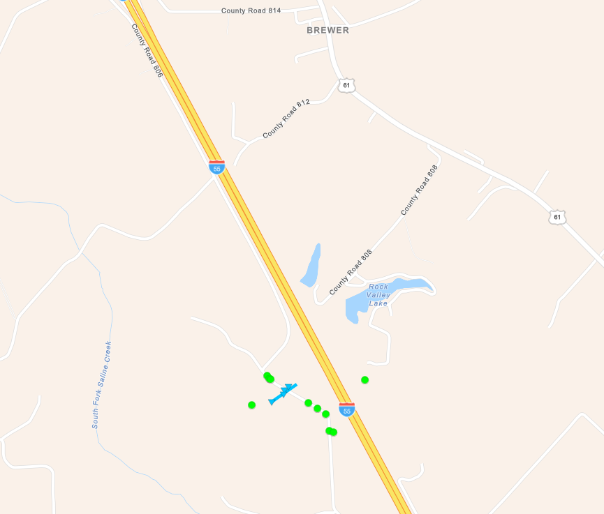
Tornado - South of Brewer, Missouri
|
||||||||||||||||
The Enhanced Fujita (EF) Scale classifies tornadoes into the following categories:
| EF0 Weak 65-85 mph |
EF1 Moderate 86-110 mph |
EF2 Significant 111-135 mph |
EF3 Severe 136-165 mph |
EF4 Extreme 166-200 mph |
EF5 Catastrophic 200+ mph |
 |
|||||
Photos
ADDITIONAL PHOTOS COMING SOON!
 |
 |
||
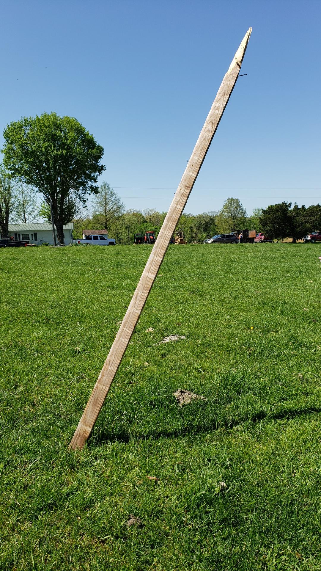
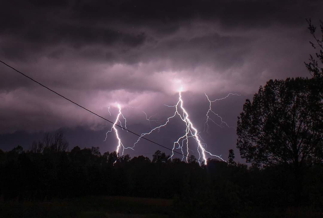
| Damage associated with tornado south of Bremen via NWS Damage Survey | Lightning near Golconda, IL via Amanda Burton | Caption (source) |
Caption (source) |
Storm Reports
PRELIMINARY LOCAL STORM REPORT...SUMMARY
NATIONAL WEATHER SERVICE PADUCAH KY
1133 PM CDT SAT APR 30 2022

..TIME...   ...EVENT...      ...CITY LOCATION...     ...LAT.LON...
..DATE...   ....MAG....      ..COUNTY LOCATION..ST.. ...SOURCE....
            ..REMARKS..

0355 PM     HAIL             1 SSW MOUNT CARMEL      38.40N 87.78W
04/30/2022  E0.75 INCH       WABASH             IL   EMERGENCY MNGR


0434 PM     HAIL             VAN BUREN               37.01N 91.01W
04/30/2022  E1.00 INCH       CARTER             MO   EMERGENCY MNGR

            ESTIMATED 45-50 MPH WINDS.

0438 PM     TSTM WND DMG     VAN BUREN               37.01N 91.01W
04/30/2022                   CARTER             MO   EMERGENCY MNGR

            2-3 INCH DIAMETER LIMBS DOWN. FLASH FLOODING
            OCCURRING ON ROADS.

0445 PM     HAIL             5 ENE VAN BUREN         37.03N 90.92W
04/30/2022  E1.75 INCH       CARTER             MO   EMERGENCY MNGR

            GOLFBALL SIZE HAIL OBSERVED NEAR JUNCTION OF
            US 60 AND HWY 21N.

0453 PM     HAIL             2 NNW MCBRIDE           37.86N 89.86W
04/30/2022  E1.50 INCH       PERRY              MO   TRAINED SPOTTER

            REPORTED TREE LIMBS DOWN AS WELL SOUTHWEST
            OF THE AIRPORT.

0504 PM     TSTM WND DMG     BREWER                  37.78N 89.93W
04/30/2022                   PERRY              MO   BROADCAST MEDIA

            DAMAGE REPORTED TO TREES AND METAL ROOFS.
            POSSIBLE TORNADO.

0505 PM     HAIL             PIEDMONT                37.15N 90.70W
04/30/2022  E0.50 INCH       WAYNE              MO   LAW ENFORCEMENT


0505 PM     HAIL             3 NW LITHIUM            37.87N 89.93W
04/30/2022  E1.00 INCH       PERRY              MO   TRAINED SPOTTER


0505 PM     HAIL             FREEMONT                36.95N 91.16W
04/30/2022  E0.50 INCH       CARTER             MO   LAW ENFORCEMENT


0506 PM     HAIL             2 SSW PIEDMONT          37.12N 90.72W
04/30/2022  E1.50 INCH       WAYNE              MO   BROADCAST MEDIA

            REPORTED ON HH HIGHWAY NEAR CLEARWATER LAKE.

0507 PM     HAIL             1 NW LEEPER             37.08N 90.72W
04/30/2022  E1.00 INCH       WAYNE              MO   PUBLIC

            REPORT FROM MPING: QUARTER (1.00 IN.).

0511 PM     TSTM WND DMG     2 S BREWER              37.76N 89.92W
04/30/2022                   PERRY              MO   TRAINED SPOTTER

            25-30 FT POLE BARN WAS DAMAGED. SHINGLES
            BLOWN OFF HOMES. SPOTTER HAD OBSERVED A
            FUNNEL CLOUD IN THE VICINITY OF THE DAMAGE.

0511 PM     TSTM WND DMG     1 S BREWER              37.76N 89.93W
04/30/2022                   PERRY              MO   TRAINED SPOTTER

            TREES AND POWER LINES DOWN. MINOR DAMAGE TO
            BUILDINGS.

0512 PM     TSTM WND GST     3 N PERRYVILLE          37.77N 89.87W
04/30/2022  E60 MPH          PERRY              MO   TRAINED SPOTTER


0520 PM     TSTM WND DMG     3 NNW MENFRO            37.82N 89.74W
04/30/2022                   PERRY              MO   911 CALL CENTER

            REPORT OF WIND DAMAGE WITH BARN LEVELED,
            ROOF DAMAGE TO BUILDING, FARM EQUIPMENT
            DAMAGED, AND POWER LINES DOWN.

0536 PM     HAIL             PIEDMONT                37.15N 90.70W
04/30/2022  M1.00 INCH       WAYNE              MO   BROADCAST MEDIA


0600 PM     HAIL             PATTERSON               37.19N 90.55W
04/30/2022  E0.88 INCH       WAYNE              MO   TRAINED SPOTTER


0610 PM     HAIL             GREENVILLE              37.13N 90.45W
04/30/2022  M1.00 INCH       WAYNE              MO   BROADCAST MEDIA


0802 PM     TSTM WND DMG     WILLISVILLE             37.98N 89.59W
04/30/2022                   PERRY              IL   TRAINED SPOTTER

            TREE UPROOTED AND FELL ON POWER LINES. TREES
            DOWN BLOCKING ROUTE-4.

0803 PM     HAIL             CUTLER                  38.03N 89.57W
04/30/2022  E1.00 INCH       PERRY              IL   TRAINED SPOTTER
 |
Media use of NWS Web News Stories is encouraged! Please acknowledge the NWS as the source of any news information accessed from this site. |
|