Overview
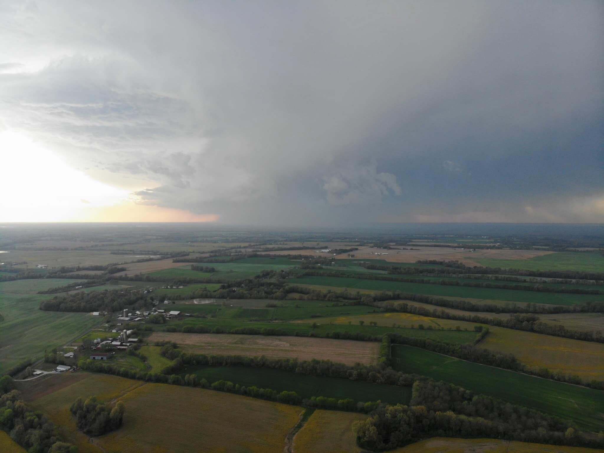
Severe thunderstorms occurred during the late afternoon and evening hours as a strong cold front moved into the area. Surface low pressure moved across central Illinois during the late afternoon hours, with our region well into the systems warm sector. High temperatures soared into the mid 80s in many locations, which helped to prime the atmosphere for severe thunderstorm development. Discrete storms formed over southeast Missouri and far southwest Illinois initially around 5 PM and quickly became severe. These storms continued to push east/southeastward into the evening hours. As the cold front approached from the northwest, a line of storms moved into the I-64 corridor but seemed to lose their intensity as they progressed across the Wabash Valley and Evansville Tri-State region. While a few wind damage reports were received, the main impact from these storms was large hail ranging from quarter sized to greater than golf balls. The largest hailstones observed were 2.25" in diameter in Sikeston, MO.Wind & Hail:
Wind
Very few wind damage reports were reported during this event. There was some wind damage associated with storms in Perry County Missouri and Jackson County Illinois. The highest observed wind gust from any observing station in the area was 63 mph at the Todd County Kentucky Mesonet station near Trenton. Just outside of our forecast area, a wind gust of 71 mph was recorded at the Mount Carmel, Illinois airport. That wind gust was associated with a potent line of storms that produced a substantial amount of wind damage before entering our area. This line did still produce some wind damage in the Petersburg, Indiana area before further decreasing in strength heading into the Evansville area.
Hail
Large hail was common with many of the storms during this event. Quarter sized hail occurred with numerous storms, but there was also some very large hail reported with a few of the stronger cells. The largest hail observed was 2.25" in the Sikeston, Missouri area. Golf ball sized hail was reported in Wayne and Bollinger Counties in Missouri.
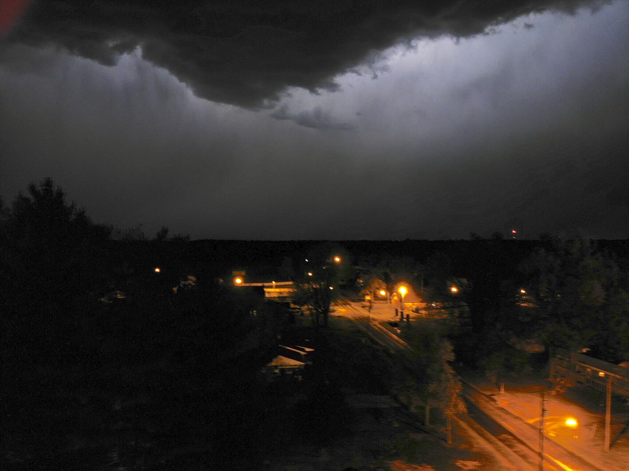
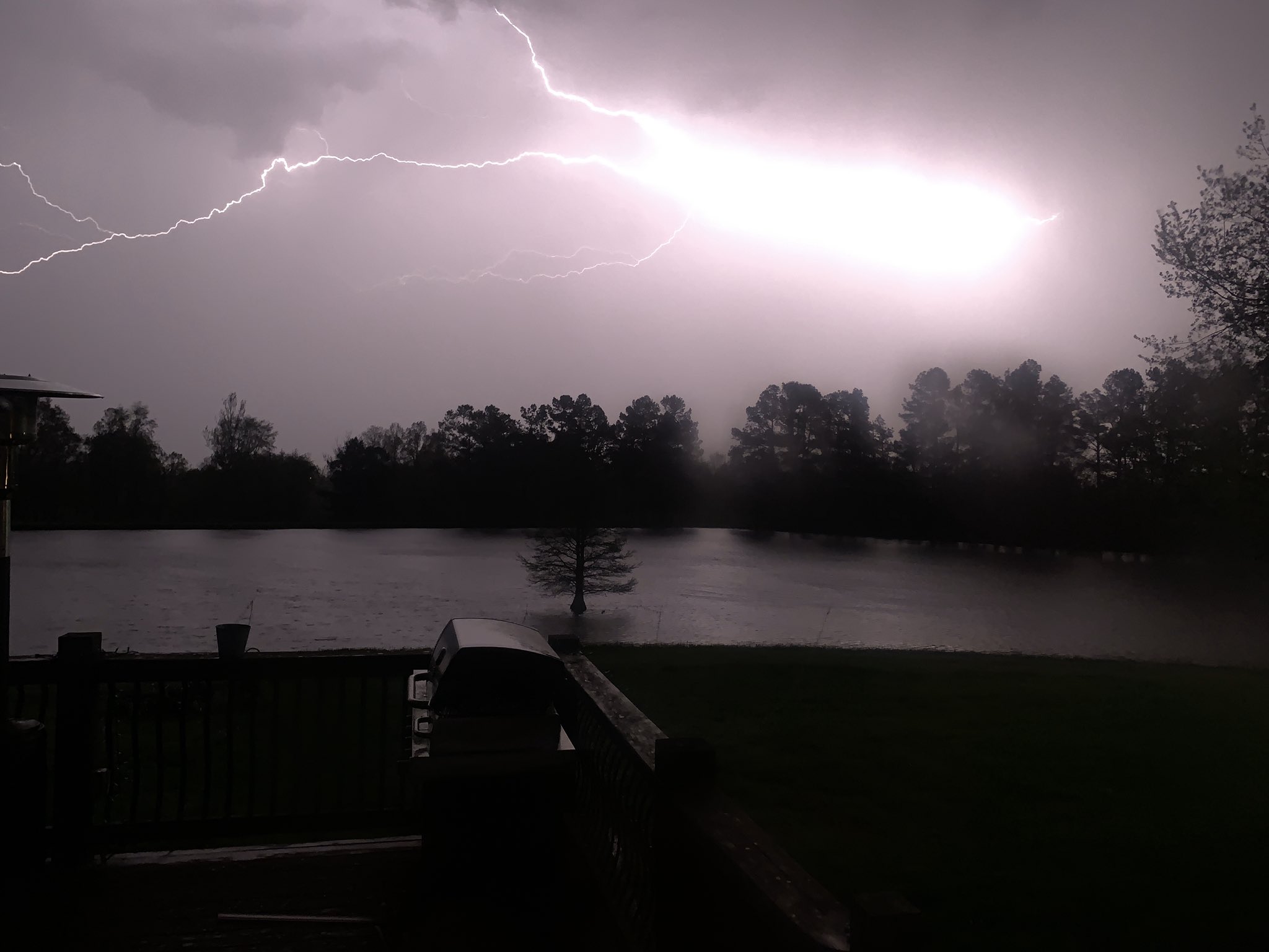
Photos
 |
 |
 |
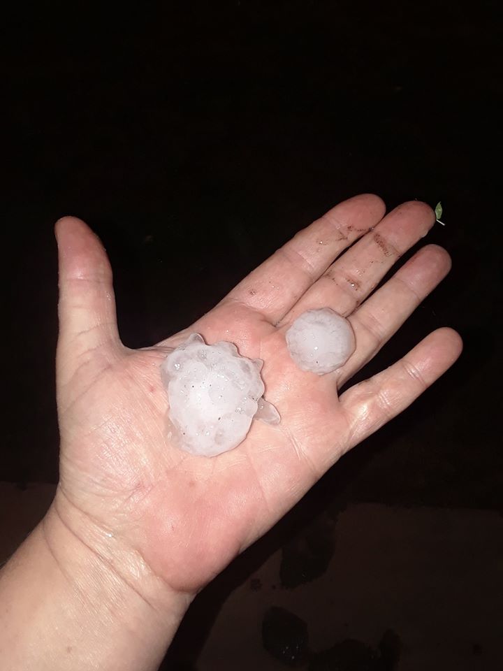 |
| Supercell structure over Alexander County IL via Michael Schulz | Lightning illuminating a gust front over Pulaski County, IL via Michael Schulz | Lightning in Wingo, KY area via Roger Gough | Golf ball sized hail in East Prairie, MO via Noah Bergren |
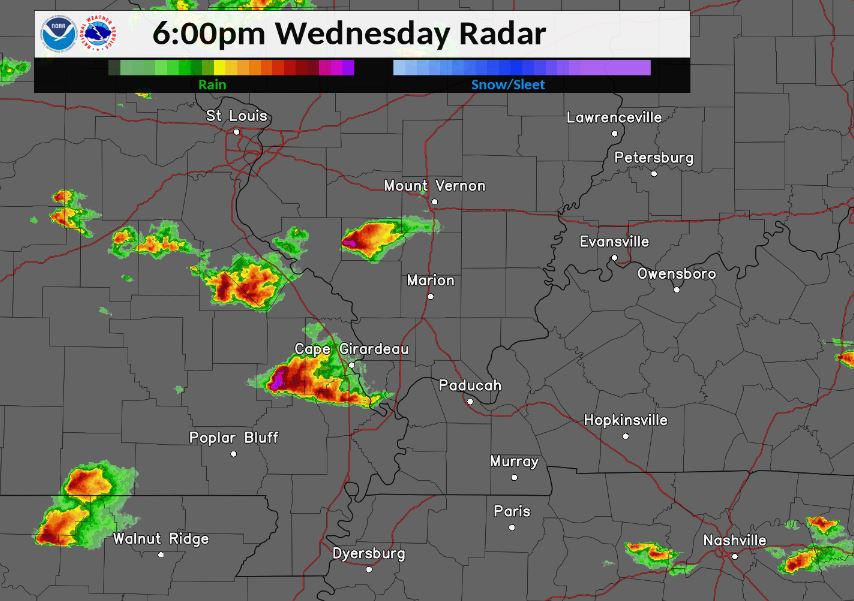
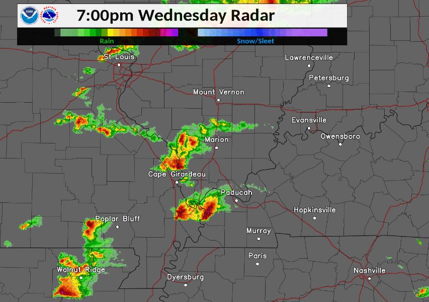
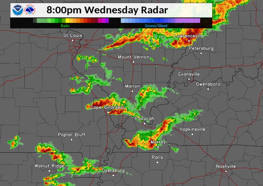
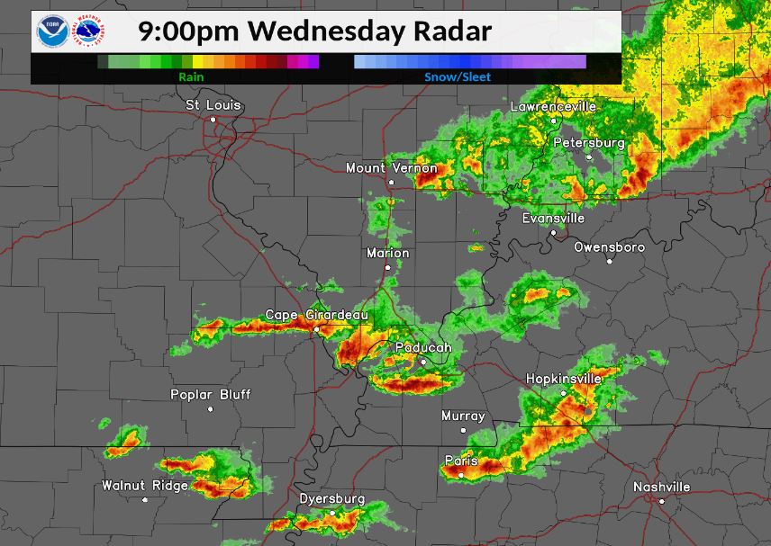
Radar
Here are snapshots of the radar at the top of each hour from 6-9 PM. This was the time period when the majority of the warnings were issued.
(Click images to enlarge)
 |
 |
 |
 |
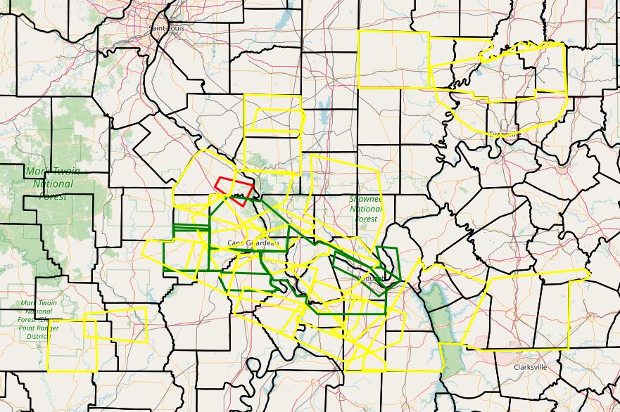
The graphic below shows all of the warnings issued during this event. There were 31 total warnings: 28 Severe Thunderstorm, 2 Flash Flood, and 1 Tornado.
 |
Storm Reports
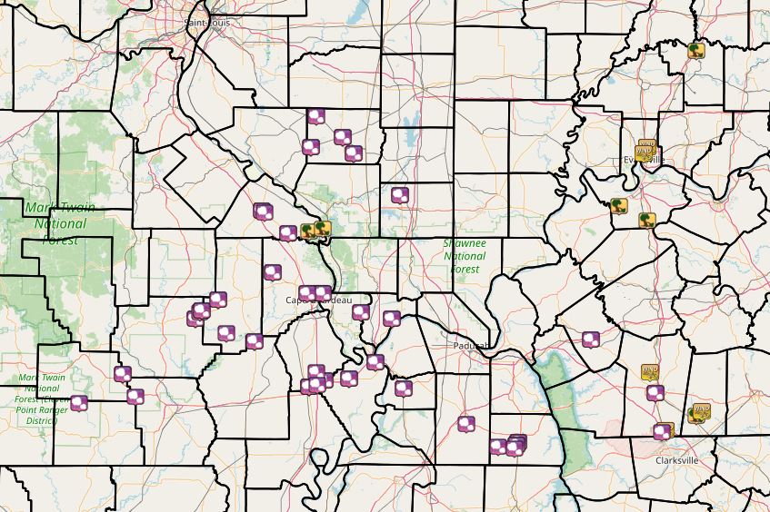 |
The graphic above depicts all LSR's issued during this event. Purple icons indicate large hail, while yellow tree icons indicate damaging winds.
PRELIMINARY LOCAL STORM REPORT...SUMMARY
NATIONAL WEATHER SERVICE PADUCAH KY
406 AM CDT THU APR 9 2020

..TIME...   ...EVENT...      ...CITY LOCATION...     ...LAT.LON...
..DATE...   ....MAG....      ..COUNTY LOCATION..ST.. ...SOURCE....
            ..REMARKS..

0538 PM     HAIL             4 E CLUBB               37.21N 90.27W
04/08/2020  E1.00 INCH       WAYNE              MO   BROADCAST MEDIA

            .

0538 PM     HAIL             SWANWICK                38.18N 89.54W
04/08/2020  E0.75 INCH       PERRY              IL   BROADCAST MEDIA

            TIME ESTIMATED FROM RADAR.

0542 PM     HAIL             4 S GRAVELTON           37.24N 90.24W
04/08/2020  E1.00 INCH       WAYNE              MO   PUBLIC

            REPORT FROM MPING: QUARTER (1.00 IN.).

0545 PM     HAIL             4 SSE GRAVELTON         37.25N 90.23W
04/08/2020  M1.75 INCH       WAYNE              MO   BROADCAST MEDIA

            .

0553 PM     HAIL             6 W GLENALLEN           37.30N 90.13W
04/08/2020  E1.75 INCH       BOLLINGER          MO   BROADCAST MEDIA

            .

0559 PM     HAIL             ZALMA                   37.14N 90.08W
04/08/2020  E1.75 INCH       BOLLINGER          MO   AMATEUR RADIO

            TIME ESTIMATED FROM RADAR.

0602 PM     HAIL             CUTLER                  38.03N 89.57W
04/08/2020  M1.50 INCH       PERRY              IL   TRAINED SPOTTER

            .

0613 PM     HAIL             ADVANCE                 37.10N 89.91W
04/08/2020  M1.00 INCH       STODDARD           MO   EMERGENCY MNGR

            .

0614 PM     HAIL             PINCKNEYVILLE           38.08N 89.38W
04/08/2020  E1.50 INCH       PERRY              IL   PUBLIC

            .

0623 PM     HAIL             PERRYVILLE              37.73N 89.87W
04/08/2020  M0.88 INCH       PERRY              MO   TRAINED SPOTTER

            .

0625 PM     HAIL             4 W DU QUOIN            38.00N 89.31W
04/08/2020  M1.00 INCH       PERRY              IL   EMERGENCY MNGR

            .

0626 PM     HAIL             1 SE PERRYVILLE         37.72N 89.85W
04/08/2020  E1.00 INCH       PERRY              MO   PUBLIC

            REPORT FROM MPING: QUARTER (1.00 IN.).

0639 PM     HAIL             UNIONTOWN               37.62N 89.71W
04/08/2020  M1.00 INCH       PERRY              MO   EMERGENCY MNGR

            .

0641 PM     TSTM WND DMG     ALTENBURG               37.63N 89.58W
04/08/2020                   PERRY              MO   EMERGENCY MNGR

            SEVERAL TREE TOPS BROKEN OFF IN FROHNA AND
            ALTENBURG. LIVE 10 INCH TREE TRUNKS SNAPPED.
            TRAMPOLINES DISPLACED. POWER OUTAGES ON THE
            WEST SIDE OF ALTENBURG.

0645 PM     HAIL             SIKESTON                36.88N 89.58W
04/08/2020  M1.00 INCH       SCOTT              MO   TRAINED SPOTTER

            .

0646 PM     HAIL             8 W GRANDIN             36.80N 90.97W
04/08/2020  E1.00 INCH       RIPLEY             MO   PUBLIC

            REPORT FROM MPING: QUARTER (1.00 IN.).

0646 PM     TSTM WND DMG     GRAND TOWER             37.64N 89.50W
04/08/2020                   JACKSON            IL   EMERGENCY MNGR

            POWER OUTAGE DUE TO THUNDERSTORM WINDS.

0649 PM     HAIL             CAIRO                   37.00N 89.18W
04/08/2020  M0.70 INCH       ALEXANDER          IL   BROADCAST MEDIA

            .

0650 PM     HAIL             4 N MINER               36.95N 89.54W
04/08/2020  E1.50 INCH       SCOTT              MO   PUBLIC

            REPORT FROM MPING: PING PONG BALL (1.50
            IN.).

0650 PM     HAIL             2 W BERTRAND            36.91N 89.49W
04/08/2020  M1.00 INCH       SCOTT              MO   TRAINED SPOTTER

            .

0651 PM     HAIL             SIKESTON                36.88N 89.58W
04/08/2020  M2.25 INCH       SCOTT              MO   BROADCAST MEDIA

            NUMEROUS REPORTS OF 1 TO 2 INCH HAIL WITH
            2.25 INCHES BEGIN THE LARGEST.

0654 PM     HAIL             MINER                   36.89N 89.53W
04/08/2020  M2.25 INCH       SCOTT              MO   BROADCAST MEDIA

            BROADCAST MEDIA PICTURES OF HAIL IN MINER.
            TIME ESTIAMTED FROM RADAR.

0709 PM     HAIL             BARDWELL                36.87N 89.01W
04/08/2020  M1.25 INCH       CARLISLE           KY   TRAINED SPOTTER

            .

0712 PM     HAIL             2 ENE ELLSINORE         36.94N 90.71W
04/08/2020  E1.00 INCH       CARTER             MO   EMERGENCY MNGR

            .

0712 PM     HAIL             10 SE ELLSINORE         36.83N 90.63W
04/08/2020  E1.00 INCH       BUTLER             MO   EMERGENCY MNGR

            CORRECTS PREVIOUS HAIL REPORT FROM 2 ENE
            ELLSINORE.

0713 PM     HAIL             CHARLESTON              36.92N 89.34W
04/08/2020  E1.00 INCH       MISSISSIPPI        MO   TRAINED SPOTTER

            .

0730 PM     HAIL             HERRIN                  37.80N 89.03W
04/08/2020  E1.00 INCH       WILLIAMSON         IL   PUBLIC

            .

0743 PM     HAIL             3 S MAYFIELD            36.70N 88.63W
04/08/2020  E1.00 INCH       GRAVES             KY   PUBLIC

            REPORT FROM MPING: QUARTER (1.00 IN.).

0750 PM     HAIL             3 NW CAPE GIRARDEAU     37.33N 89.59W
04/08/2020  M0.75 INCH       CAPE GIRARDEAU     MO   PUBLIC

            REPORT FROM MPING: DIME (0.75 IN.).

0752 PM     HAIL             3 NE CAPE GIRARDEAU     37.33N 89.51W
04/08/2020  E1.00 INCH       CAPE GIRARDEAU     MO   TRAINED SPOTTER

            .

0752 PM     HAIL             1 NW CAPE GIRARDEAU     37.33N 89.56W
04/08/2020  E1.00 INCH       CAPE GIRARDEAU     MO   PUBLIC

            REPORT FROM MPING: QUARTER (1.00 IN.).

0756 PM     HAIL             3 ENE CAPE GIRARDEAU    37.33N 89.50W
04/08/2020  E1.00 INCH       CAPE GIRARDEAU     MO   BROADCAST MEDIA

            .

0800 PM     HAIL             LYNN GROVE              36.59N 88.44W
04/08/2020  E1.00 INCH       CALLOWAY           KY   PUBLIC

            REPORT FROM MPING: QUARTER (1.00 IN.).

0807 PM     HAIL             MURRAY                  36.61N 88.32W
04/08/2020  M1.00 INCH       CALLOWAY           KY   TRAINED SPOTTER

            .

0808 PM     HAIL             PRINCETON               37.11N 87.88W
04/08/2020  M1.00 INCH       CALDWELL           KY   TRAINED SPOTTER

            .

0815 PM     TSTM WND DMG     2 E PETERSBURG          38.49N 87.24W
04/08/2020                   PIKE               IN   PUBLIC

            REPORT FROM MPING: TREES UPROOTED OR
            SNAPPED; ROOF BLOWN OFF.

0818 PM     HAIL             1 SW MURRAY             36.60N 88.33W
04/08/2020  E1.50 INCH       CALLOWAY           KY   PUBLIC

            .

0823 PM     HAIL             MILLERSVILLE            37.43N 89.80W
04/08/2020  E1.00 INCH       CAPE GIRARDEAU     MO   BROADCAST MEDIA

            .

0825 PM     HAIL             3 SW MURRAY             36.58N 88.34W
04/08/2020  E1.00 INCH       CALLOWAY           KY   PUBLIC

            REPORT FROM MPING: QUARTER (1.00 IN.).

0831 PM     HAIL             2 N OLMSTED             37.21N 89.08W
04/08/2020  M0.70 INCH       PULASKI            IL   EMERGENCY MNGR

            .

0835 PM     HAIL             HOPKINSVILLE            36.85N 87.49W
04/08/2020  M1.00 INCH       CHRISTIAN          KY   EMERGENCY MNGR

            .

0840 PM     TSTM WND GST     7 NNW HOPKINSVILLE      36.95N 87.52W
04/08/2020  M48 MPH          CHRISTIAN          KY   MESONET

            MESONET STATION PGHL HOPKINSVILLE 6 N.

0843 PM     HAIL             TAMMS                   37.24N 89.27W
04/08/2020  M1.00 INCH       ALEXANDER          IL   BROADCAST MEDIA

            .

0854 PM     TSTM WND GST     3 N EVANSVILLE          38.03N 87.54W
04/08/2020  M52 MPH          VANDERBURGH        IN   ASOS

            .

0855 PM     TSTM WND GST     OAK GROVE               36.67N 87.43W
04/08/2020  E55 MPH          CHRISTIAN          KY   TRAINED SPOTTER

            .

0856 PM     HAIL             3 NW CAPE GIRARDEAU     37.33N 89.59W
04/08/2020  E1.00 INCH       CAPE GIRARDEAU     MO   PUBLIC

            REPORT FROM MPING: QUARTER (1.00 IN.).

0857 PM     HAIL             1 NE FORT CAMPBELL NORT 36.66N 87.45W
04/08/2020  E0.75 INCH       CHRISTIAN          KY   PUBLIC

            REPORT FROM MPING: DIME (0.75 IN.).

0858 PM     TSTM WND GST     1 NW EVANSVILLE         38.00N 87.56W
04/08/2020  E50 MPH          VANDERBURGH        IN   PUBLIC

            .

0900 PM     TSTM WND DMG     ROBARDS                 37.68N 87.54W
04/08/2020                   HENDERSON          KY   FIRE DEPT/RESCUE

            POWER POLES SNAPPED ON SWANN LANE IN
            ROBARDS. TIME ESTIMATED.

0900 PM     TSTM WND DMG     1 N CORYDON             37.75N 87.71W
04/08/2020                   HENDERSON          KY   FIRE DEPT/RESCUE

            TREE DOWN ON HIGHWAY 266 WEST OF CORYDON.
            TIME ESTIMATED.

0905 PM     TSTM WND GST     4 NE TRENTON            36.76N 87.21W
04/08/2020  M63 MPH          TODD               KY   MESONET

            MESONET STATION ZION ELKTON 5 SW.

0905 PM     TSTM WND DMG     2 NE TRENTON            36.74N 87.24W
04/08/2020                   TODD               KY   BROADCAST MEDIA

            PART OF A BARN BLOWN ONTO A ROAD. TIME
            ESTIMATED.
Environment
Near-storm environment:
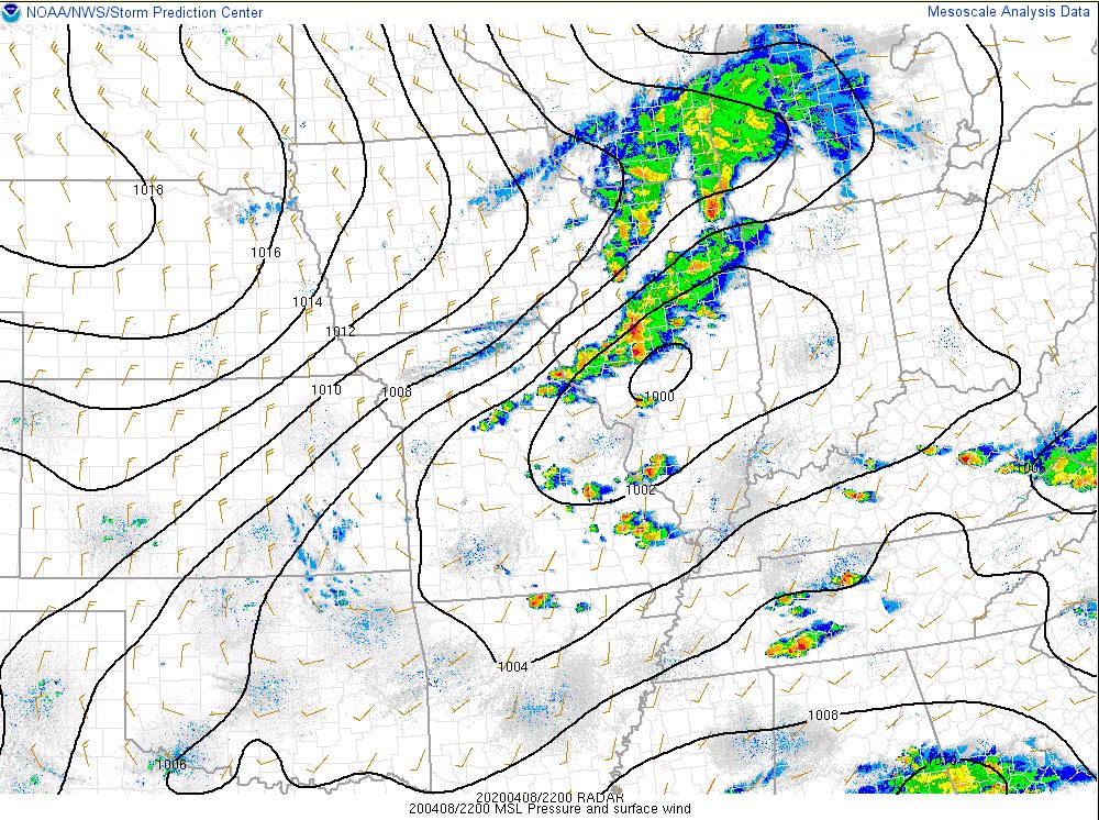 |
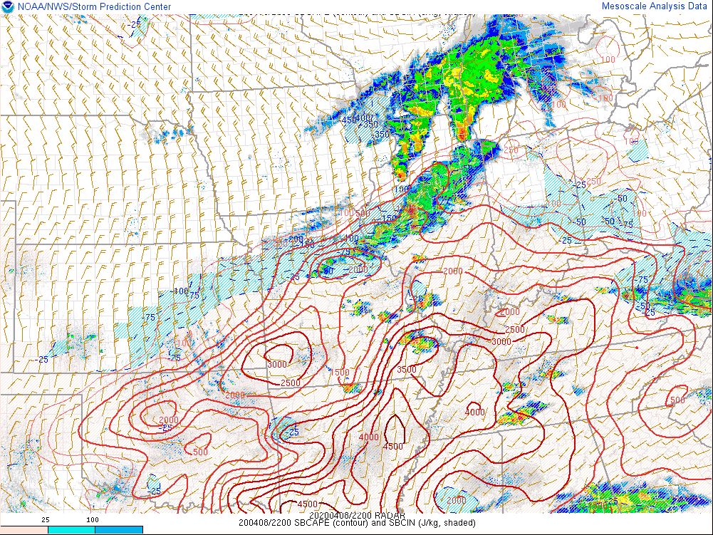 |
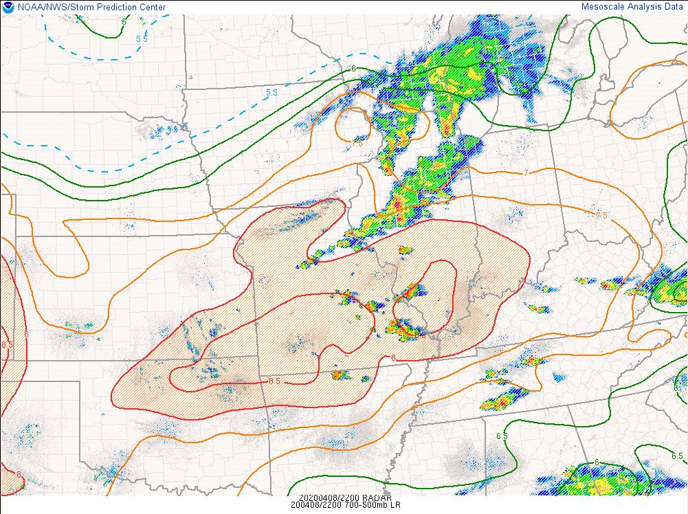 |
| MSLP and surface winds at 5 PM | Surface CAPE at 5 PM | Mid level lapse rates at 5 PM |
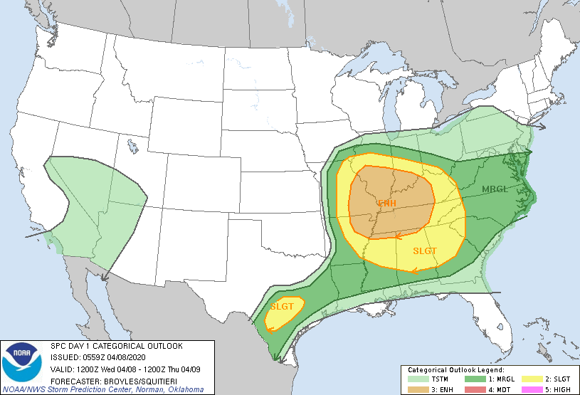
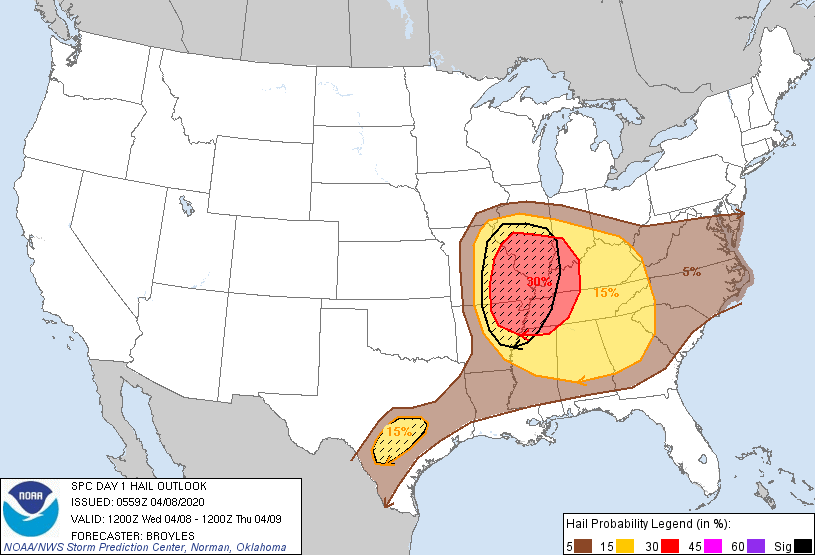
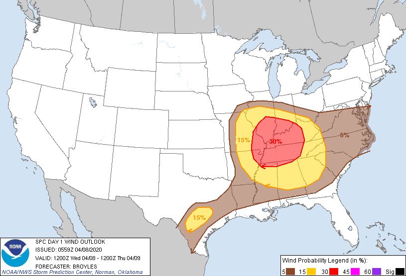
Storm Prediction Center Day 1 Outlook issued at 1 AM on April 8, 2020:
 |
 |
 |
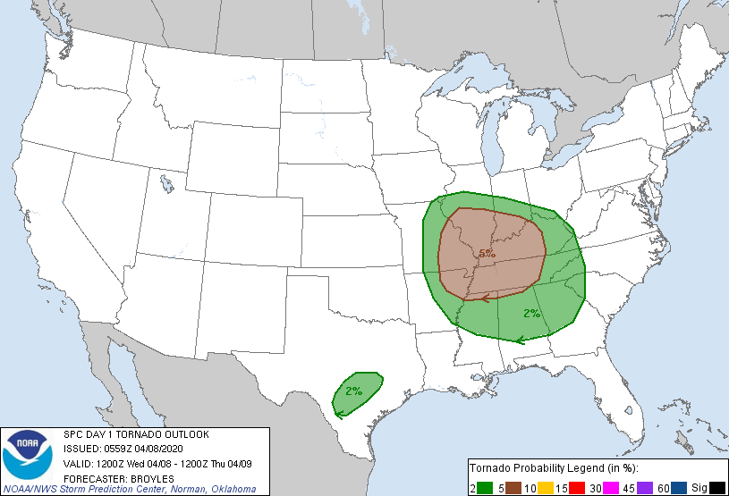 |
| Convective Outlook | Day 1 Hail Risk | Day 1 Wind Risk | Day 1 Tornado Risk |
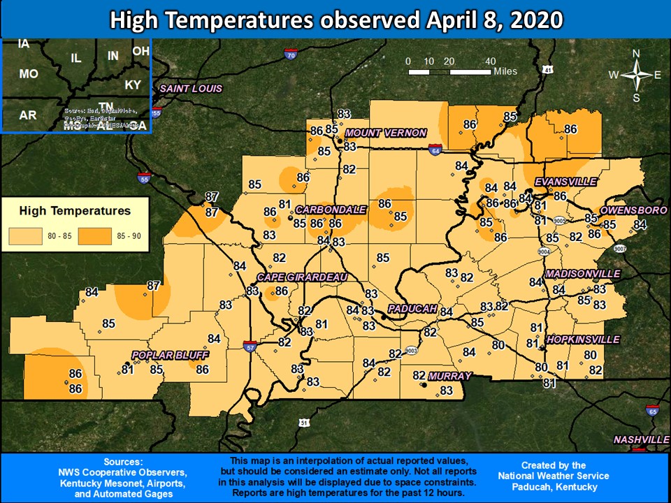
Observed High Temperatures: (Record high of 86 was set in Evansville, IN and record high of 85 was tied in Cape Girardeau, MO)
 |
Additional data.
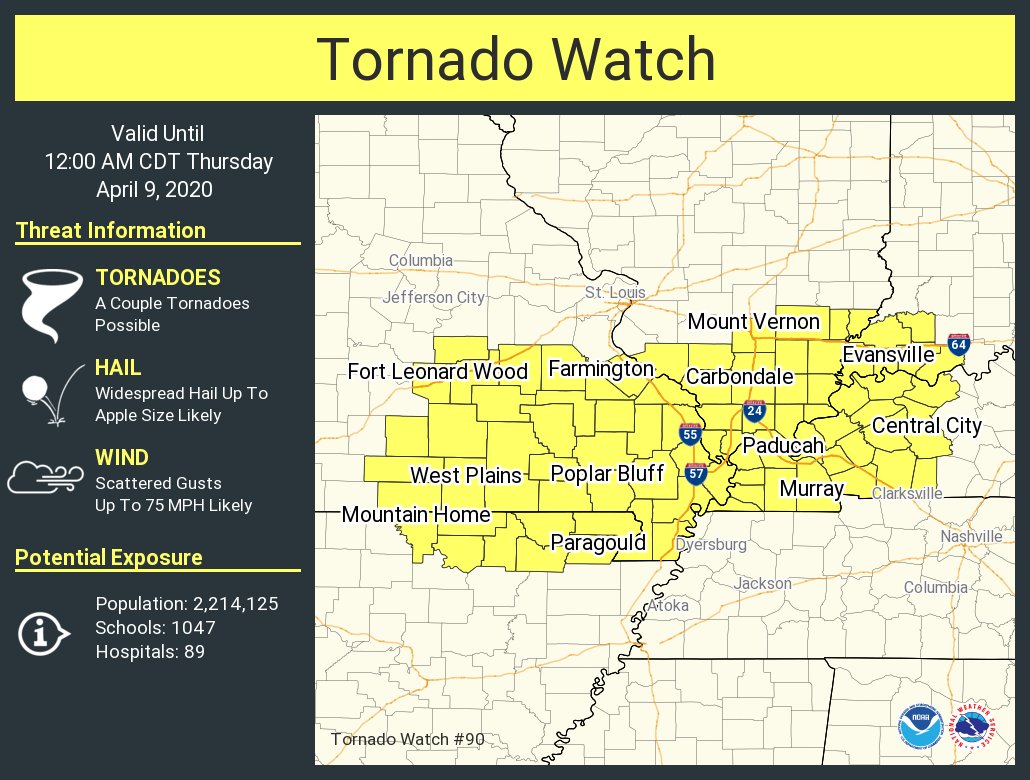 |
| Tornado Watch in effect for entire region, Valid from 4:25 PM until Midnight (the watch was cancelled around 10:45 PM) |
 |
Media use of NWS Web News Stories is encouraged! Please acknowledge the NWS as the source of any news information accessed from this site. |
|

