Overview
Multiple lines of thunderstorms formed across southeast Missouri after midnight on April 2, 2024. The southern line really took off as it quickly ejected east across the Mississippi River, racing across southern Illinois and into western Kentucky and southwest Indiana between 3 and 7 AM. This thunderstorm complex remained intact across Kentucky and all the way to West Virginia. This event officially met the definition requirements of a derecho, with widespread significant wind damage. Embedded within the line were dozens of circulations that led to 19 tornadoes across our forecast area. This was the most tornadoes in a single event across our Quad-State region since Halloween 2013 (19 tornadoes that day). There were 7 EF-2's, 11 EF-1's, and 1 EF-0 tornadoes with this event.
Tornadoes:
|
Tornado #1 - West of Cape Girardeau
|
||||||||||||||||
|
Tornado #2 - Lake of Egypt, IL
|
||||||||||||||||
|
Tornado #3 - Stonefort, IL
|
||||||||||||||||
|
Tornado #4 - El Dorado, IL (Southeast)
|
||||||||||||||||
|
Tornado #5 - Ridgway, IL
|
||||||||||||||||
|
Tornado #6 - New Haven, IL (South)
|
||||||||||||||||
|
Tornado #7 - Harmonie State Park, IN
|
||||||||||||||||
|
Tornado #8 - Blairsville, IN (South)
|
||||||||||||||||
|
Tornado #9 - St. Wendel & Hillsdale, IN
|
||||||||||||||||
|
Tornado #10 - Darmstadt, IN (North)
|
||||||||||||||||
|
Tornado #11 - Elberfeld, IN #1 (South)
|
||||||||||||||||
|
Tornado #12 - Elberfeld, IN #2 (South)
|
||||||||||||||||
|
Tornado #13 - Lynnville, IN (South)
|
||||||||||||||||
|
Tornado #14 - Kevil, KY (Northeast)
|
||||||||||||||||
|
Tornado #15 - Ridgway, IL (East)
|
||||||||||||||||
|
Tornado #16 - Uniontown, KY (South)
|
||||||||||||||||
|
Tornado #17 - Morganfield, KY (North)
|
||||||||||||||||
|
Tornado #18 - Sullivan, KY
|
||||||||||||||||
|
Tornado #19 - SE of Chandler, IN
|
||||||||||||||||
The Enhanced Fujita (EF) Scale classifies tornadoes into the following categories:
| EF0 Weak 65-85 mph |
EF1 Moderate 86-110 mph |
EF2 Significant 111-135 mph |
EF3 Severe 136-165 mph |
EF4 Extreme 166-200 mph |
EF5 Catastrophic 200+ mph |
 |
|||||
Wind:
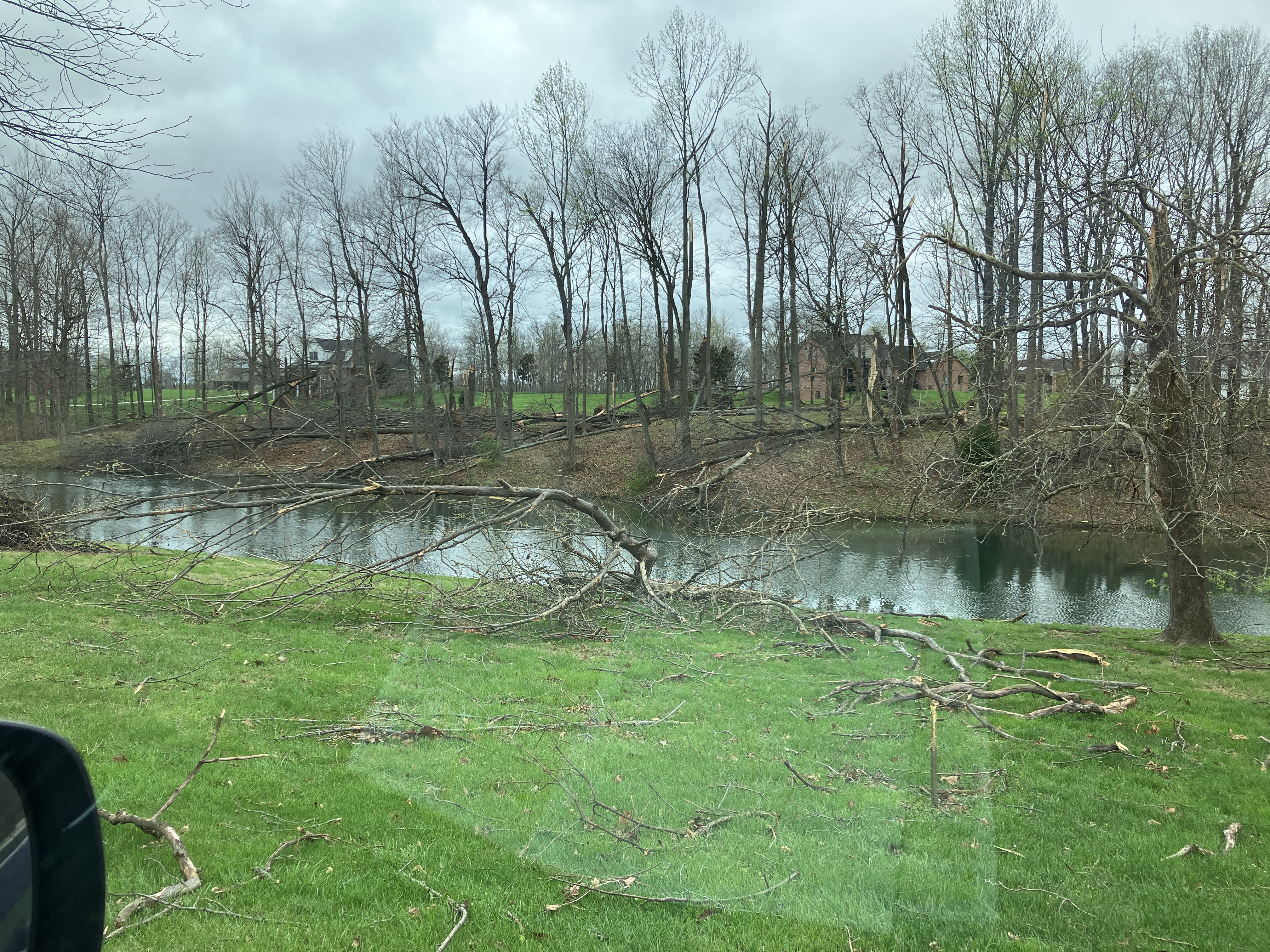
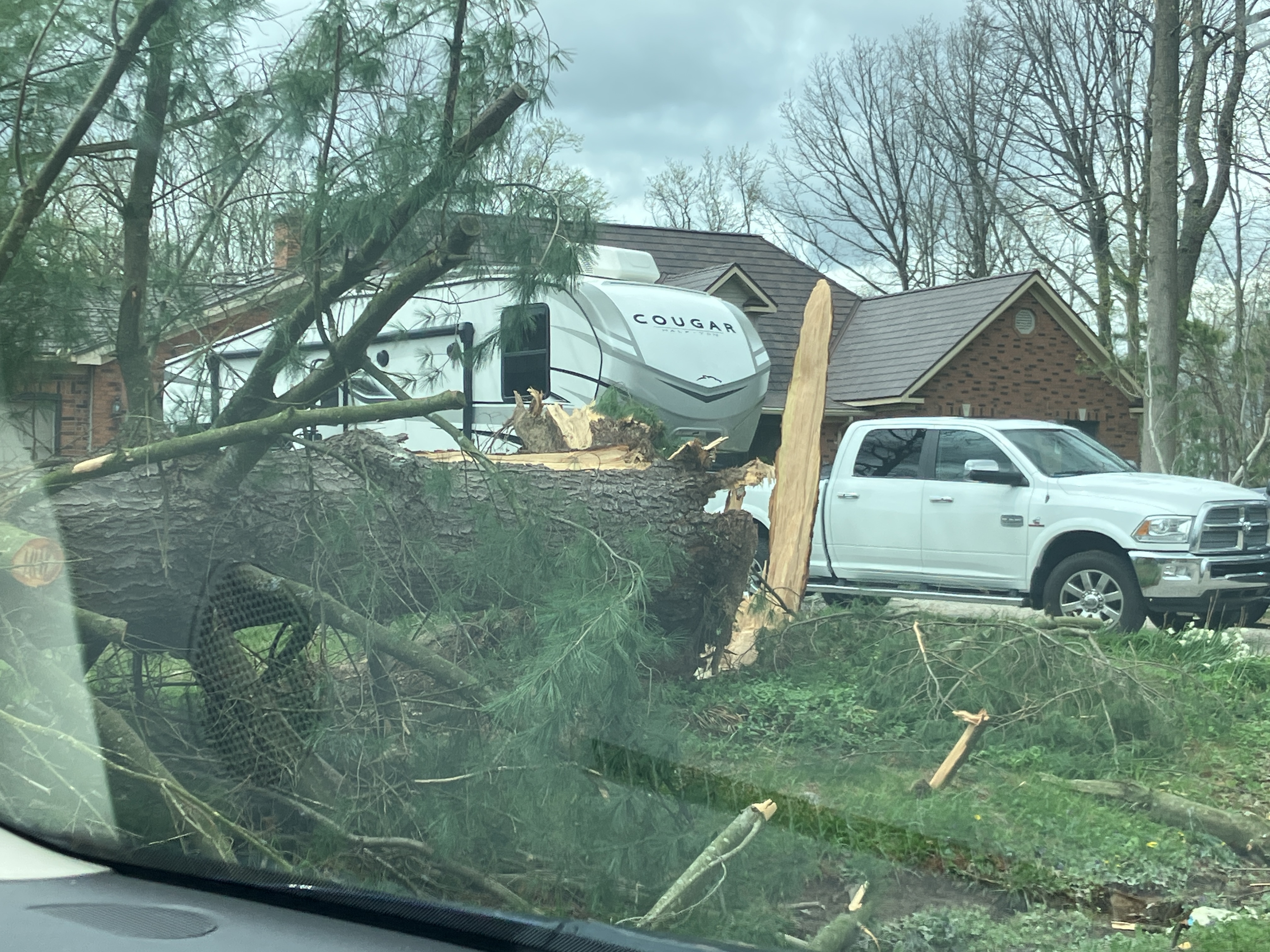
Significant straight-line wind damage occurred in many areas outside of the tornadoes. Swaths of 70-95 mph winds produced widespread downed trees and some damage to homes and businesses. We have confirmed that three microbursts occurred, one was north of Mount Vernon, Indiana and the other south of Boonville, Indiana. Additional areas of concentrated damage included the north side of Evansville, Indiana, south of the Lake of Egypt tornado in southern Williamson County, Illinois, and the west side of Cape Girardeau, Missouri. Additionally, a macroburst with peak winds of 95 mph impacted portions of far eastern Posey and central Vanderburgh County, IN. This macroburst caused significant tree and roof and siding damage, including damage to a hanger and the Evansville Regional Airport, where an 84 mph wind gust was measured.
 |
 |
| Microburst swath in Posey County, Indiana Downloadable KMZ File |
Microburst swath in Warrick County Indiana Downloadable KMZ File |
 |
 |
| Microburst swath in Cape Girardeau County, Missouri Downloadable KMZ File |
Macroburst swath in Posey and Vanderburgh County, IN Downloadable KMZ File |
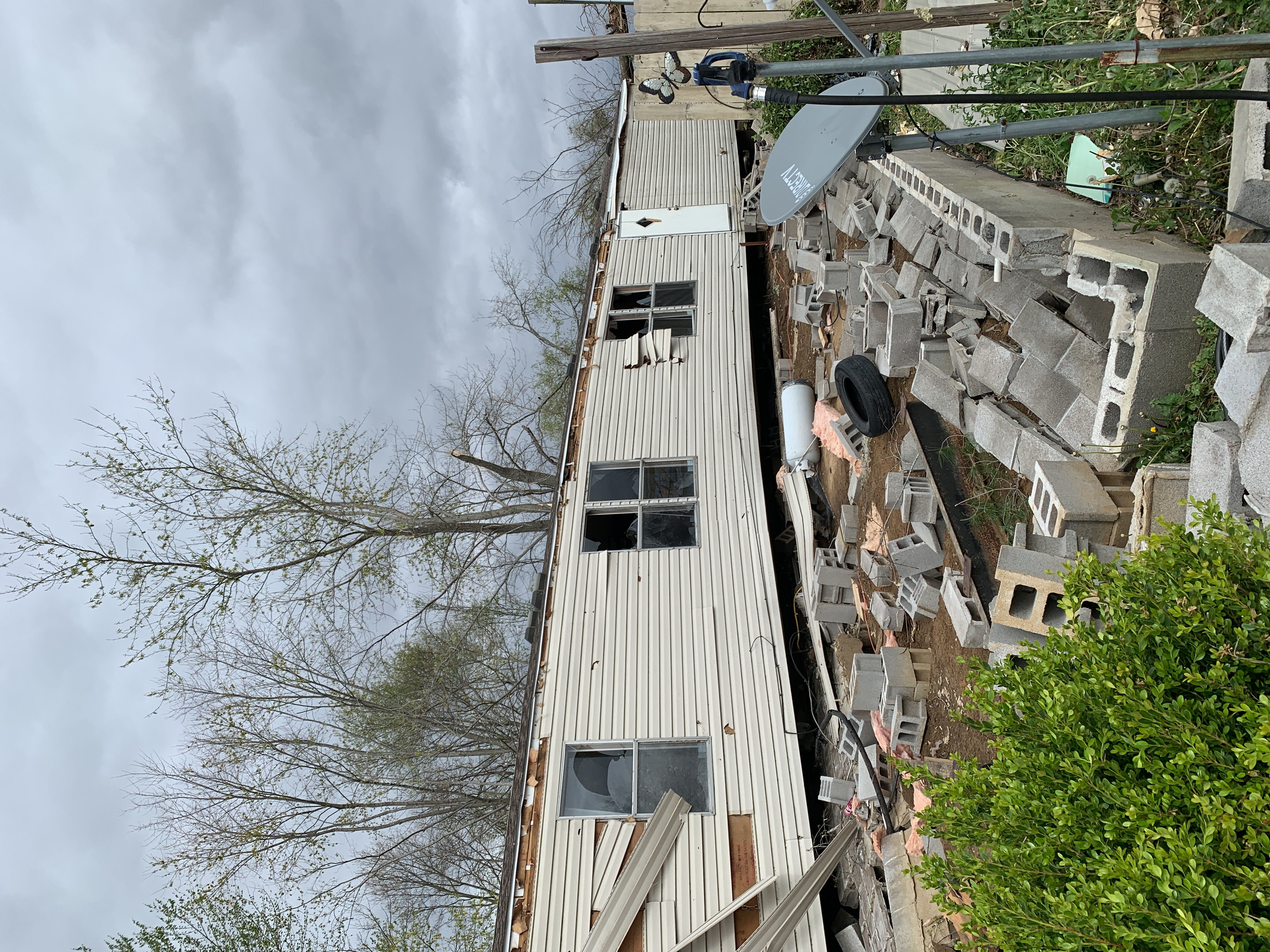
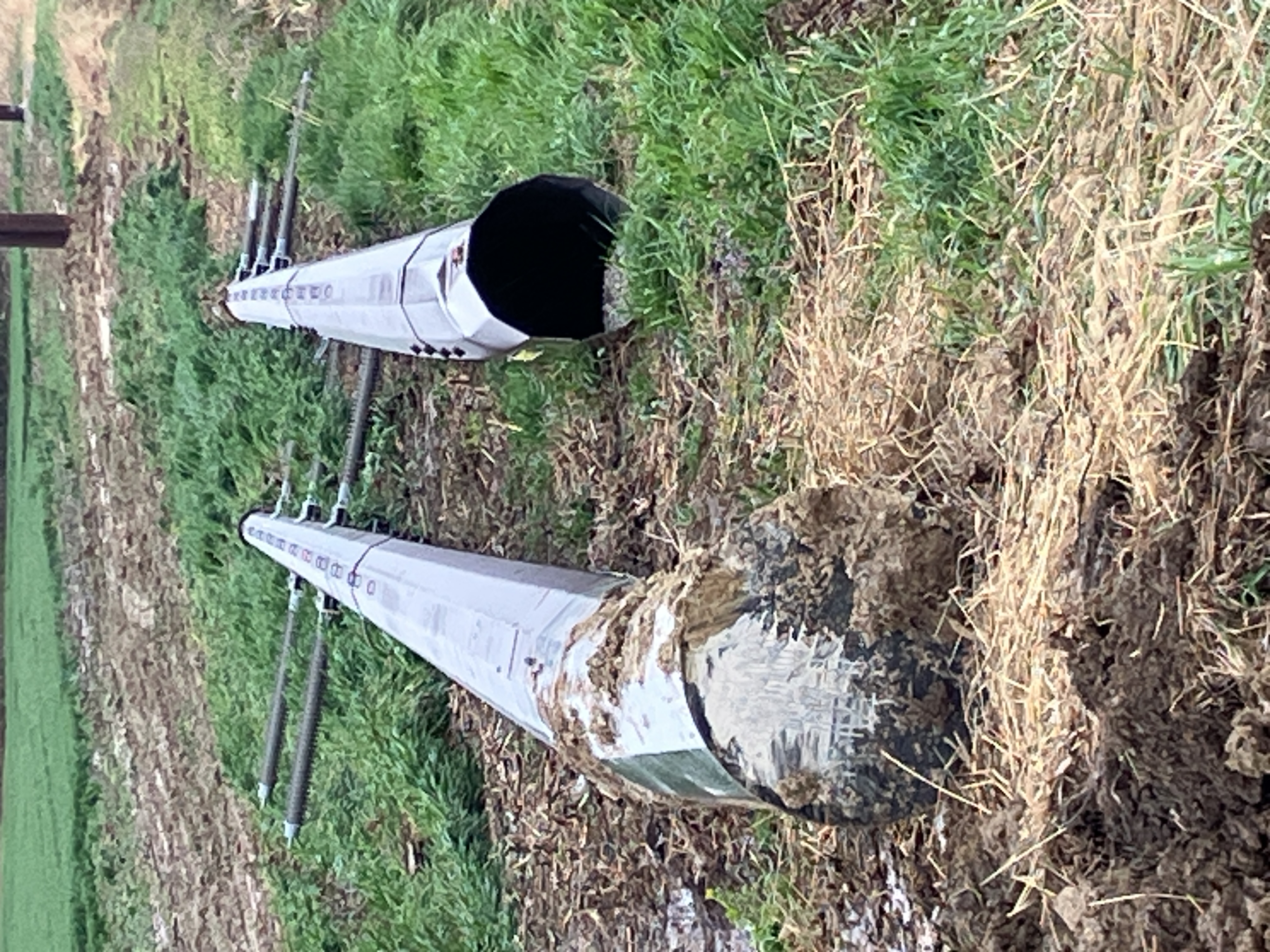
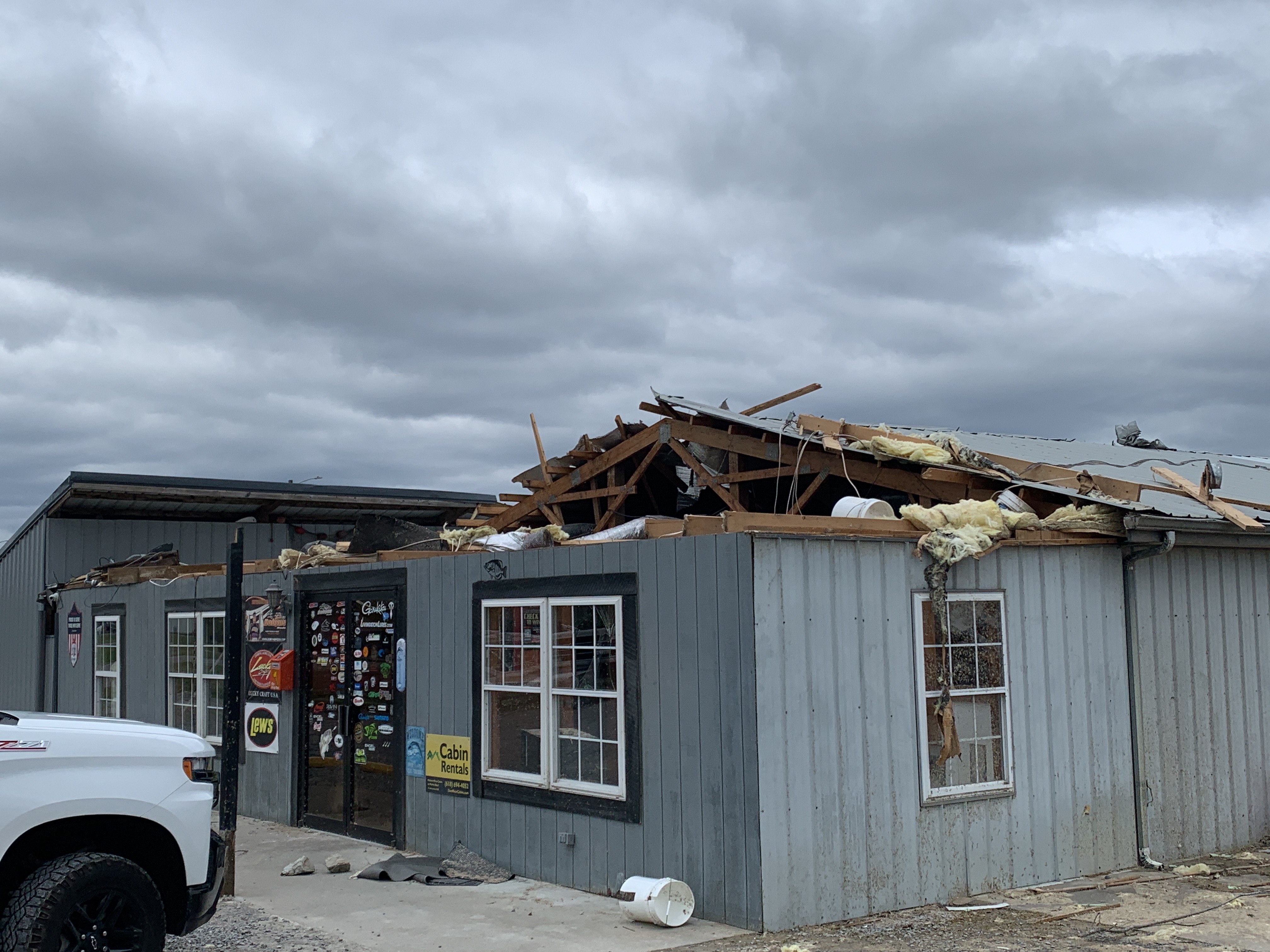
Photos
 |
 |
 |
.jpg) |
| NWS Damage Survey southeast of El Dorado, IL | NWS Damage Survey northern Vanderburgh County, IN | Damage from Lake of Egypt Tornado in Illinois | Damage from Lake of Egypt Tornado in Illinois |
 |
 |
 |
.png) |
| NWS Damage Survey in Posey County Indiana | NWS Damage Survey in Posey County Indiana | NWS Damage Survey in Posey County Indiana | Damage in Evansville, Indiana |
 |
.png) |
 |
.jpg) |
| NWS Damage Survey in St. Wendel, Indiana | Tornado damage in Stonefort, Illinois | NWS Damage Survey south of Uniontown, KY | Tornado damage along Woodville Road in McCracken County Kentucky |
Radar
Here is a radar loop of the event. The loop runs from 10 PM on April 1st through 7 PM on April 2nd. Multiple rounds of thunderstorms impacted the region. The most widespread damage and all of the tornadoes occurred with the line of thunderstorms that moved through from about 2:30 AM until 7 AM on April 2nd.
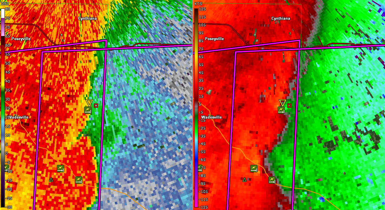
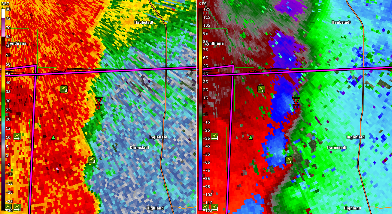
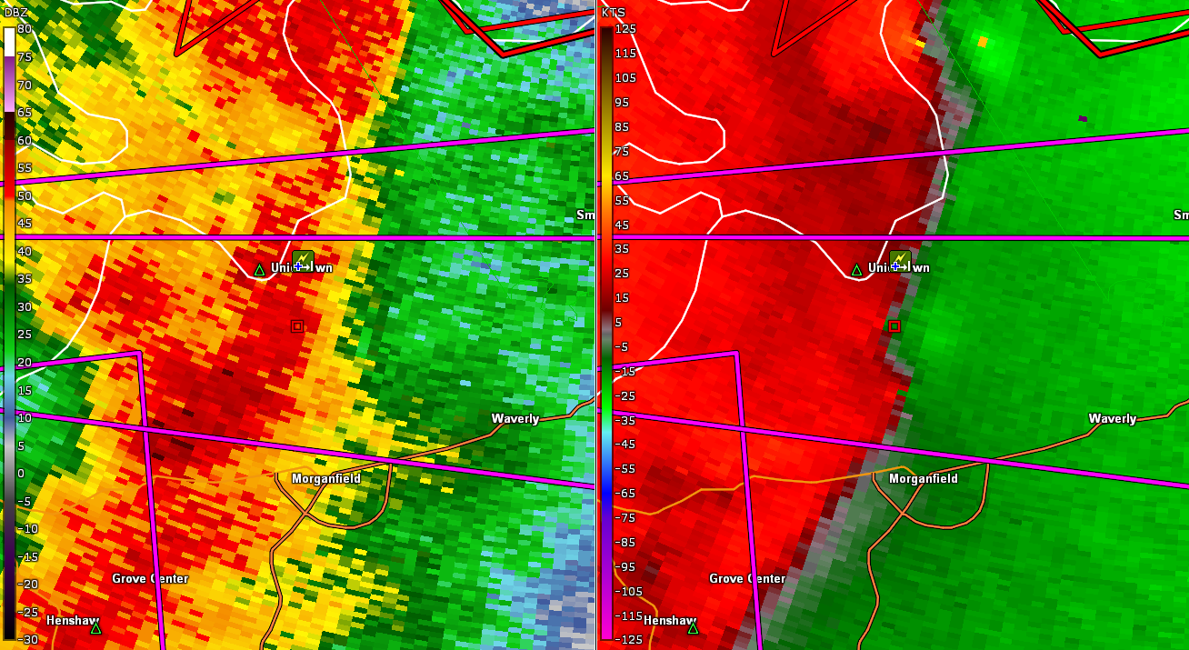
The images below are radar snapshots for each of the 7 EF-2 tornadoes that occurred with this event
 |
 |
 |
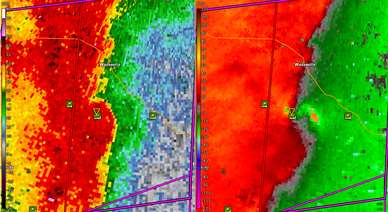 |
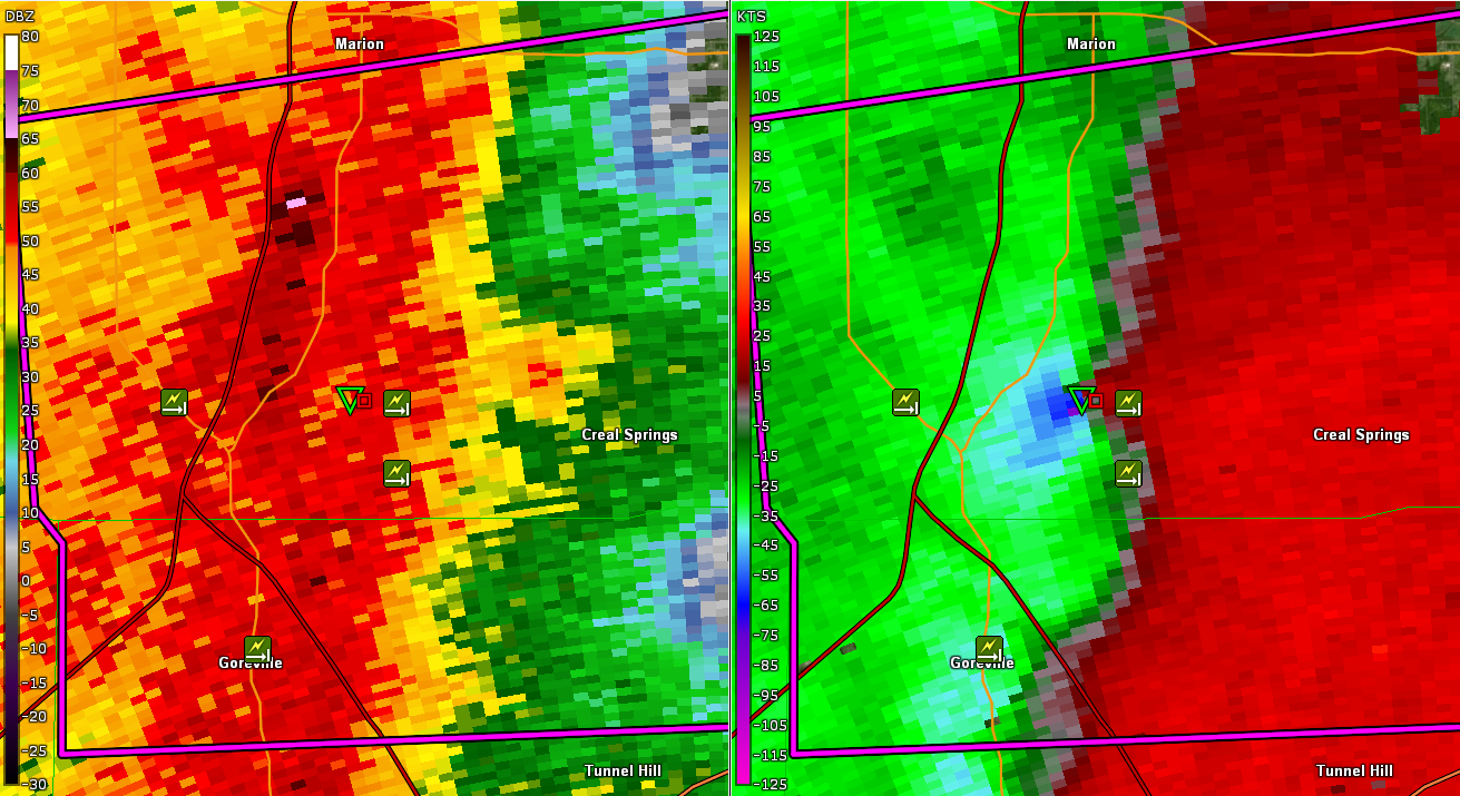
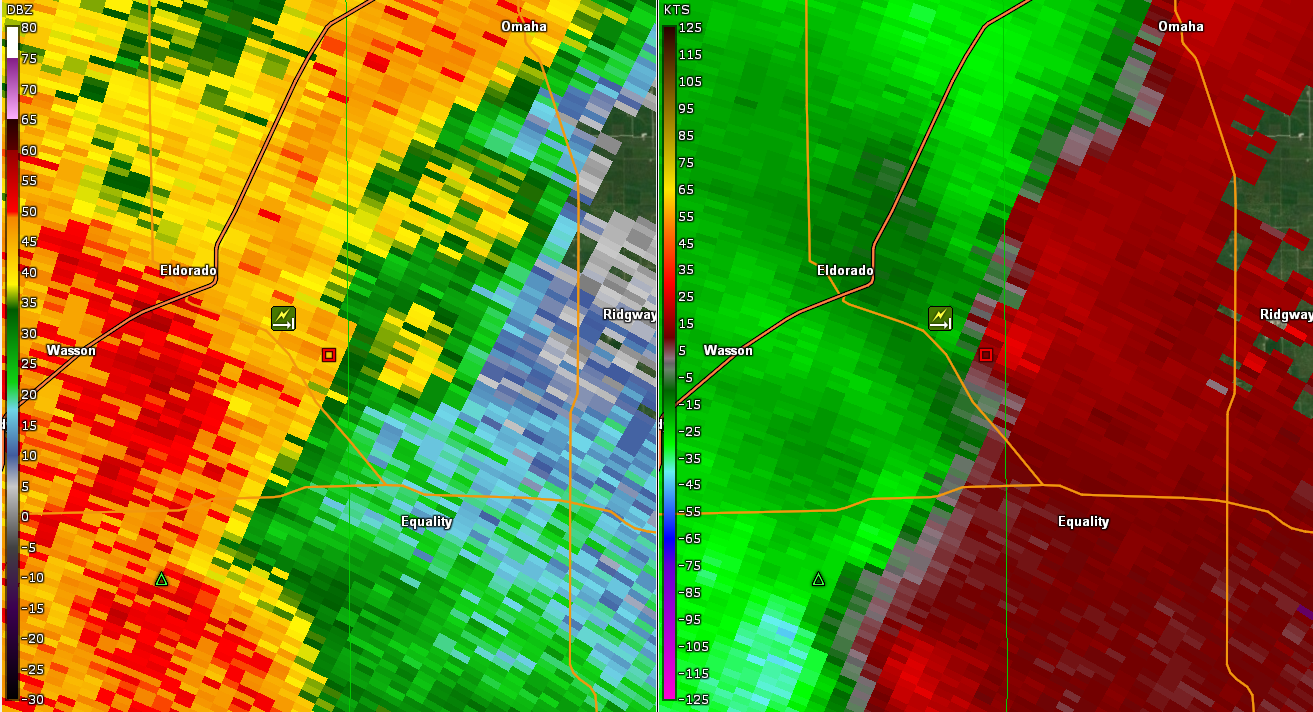
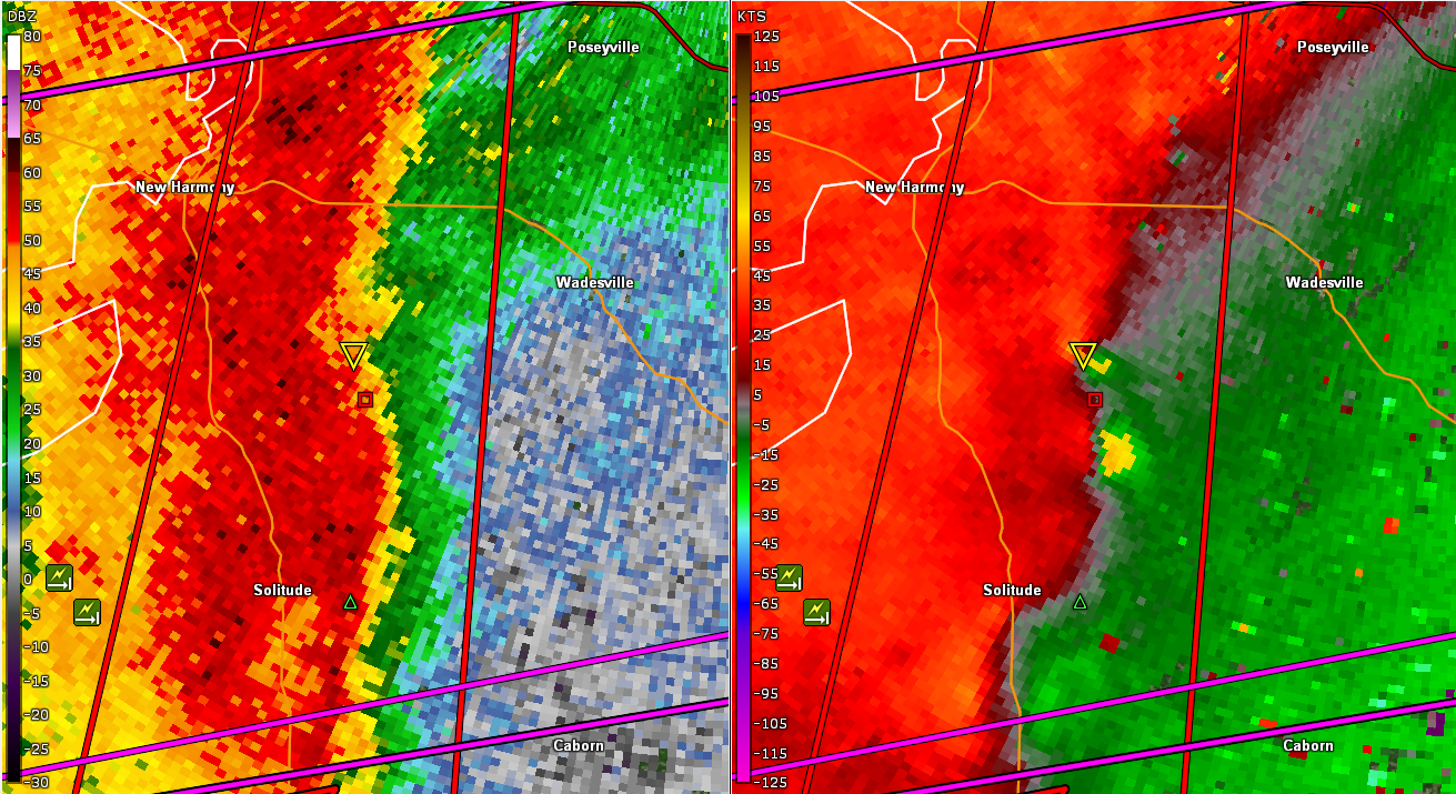
| Radar Reflectivity and Storm Relative Velocity for Lake of Egypt, IL EF-2 | Radar Reflectivity and Storm Relative Velocity for El Dorado, IL EF-2 | Radar Reflectivity and Storm Relative Velocity for Posey County, IN EF-2's before they merged | Radar Reflectivity and Storm Relative Velocity for Posey County, IN EF-2 after merging |
 |
 |
 |
| Radar Reflectivity and Storm Relative Velocity for St. Wendel, IN EF-2 | Radar Reflectivity and Storm Relative Velocity for Northern Vanderburgh County, IN EF-2 | Radar Reflectivity and Storm Relative Velocity for Uniontown, KY EF-2 |
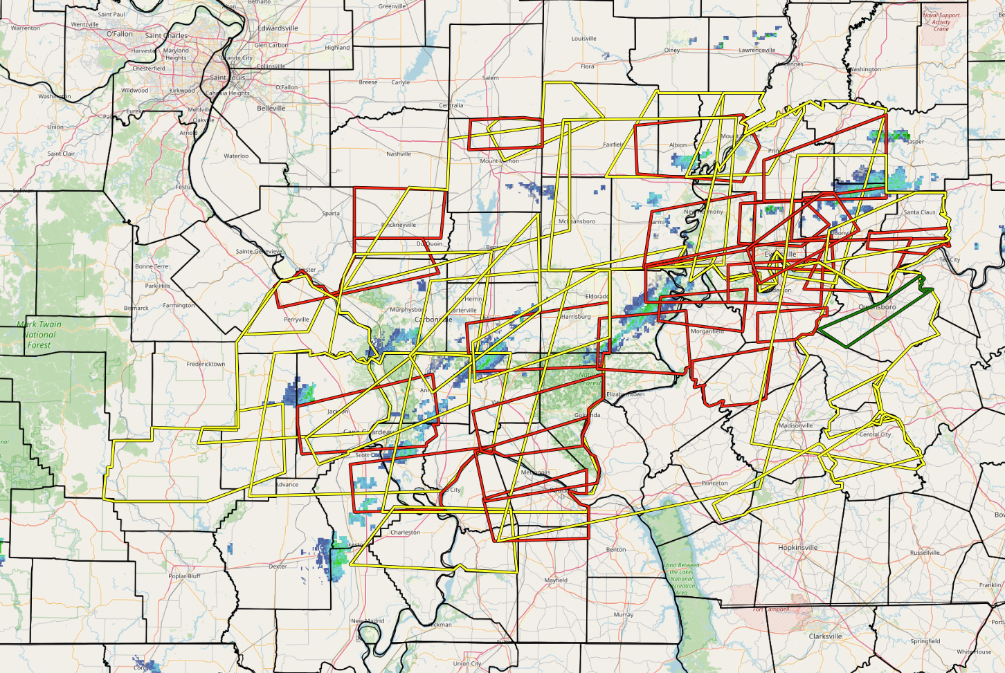
The graphics below show the warnings issued during the event. Map on the left is all warnings and on the right is the Tornado Warnings issued for each county.
 |
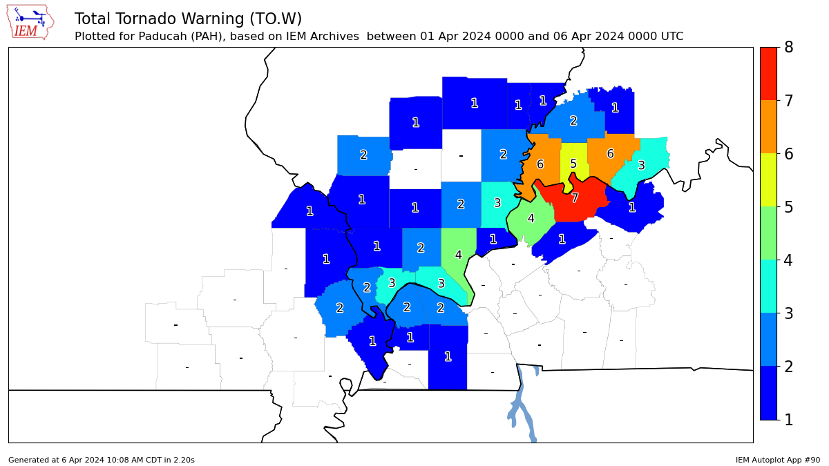 |
| Map of Severe Thunderstorm and Tornado warnings issued during this event. | Total number of Tornado Warnings issued for each county |
Storm Reports
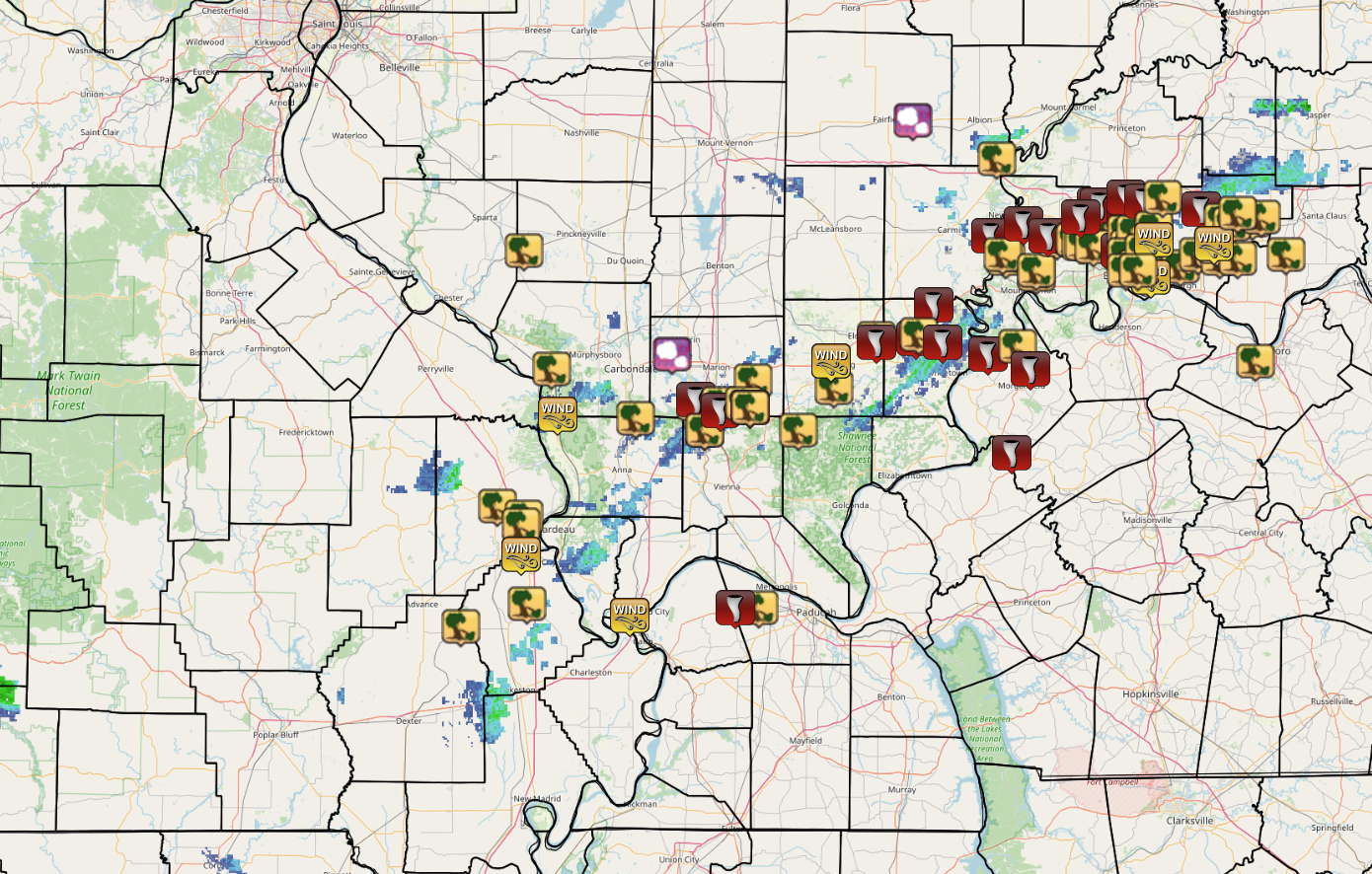 |
| Map of local storm reports from the event. Icons including tornadoes, thunderstorm wind gusts/damage, and hail. |
Preliminary Local Storm Report...Summary
National Weather Service Paducah KY
303 PM CDT Wed Apr 3 2024

..TIME...   ...EVENT...      ...CITY LOCATION...     ...LAT.LON...
..DATE...   ....MAG....      ..COUNTY LOCATION..ST.. ...SOURCE....
            ..REMARKS..

0244 AM     Tstm Wnd Dmg     Cutler                  38.03N 89.57W
04/02/2024                   Perry              IL   Emergency Mngr

            Tree downed onto a trailer in Culter. Time
            estimated by radar.

0415 AM     Hail             4 WNW Golden Gate       38.37N 88.28W
04/02/2024  E1.50 Inch       Wayne              IL   Public

            Report from mPING of 1.5 inch hail.

0415 AM     Tstm Wnd Dmg     2 ENE Bell City         37.04N 89.78W
04/02/2024                   Stoddard           MO   Public

            Damage to a barn.

0417 AM     Tstm Wnd Dmg     1 SSW Jackson           37.36N 89.66W
04/02/2024                   Cape Girardeau     MO   Law Enforcement

            Trees down on powerlines.

0417 AM     Tstm Wnd Dmg     Gorham                  37.72N 89.48W
04/02/2024                   Jackson            IL   Emergency Mngr

            428 residents out of power in the
            Gorham/Grand Tower Area.

0420 AM     Tstm Wnd Dmg     2 NW Cape Girardeau     37.33N 89.57W
04/02/2024                   Cape Girardeau     MO   Broadcast Media

            Roof damage to a house on Highland Drive.

0420 AM     Tstm Wnd Dmg     2 WNW Cape Girardeau    37.31N 89.58W
04/02/2024                   Cape Girardeau     MO   Amateur Radio

            A couple large trees down.

0422 AM     Tstm Wnd Gst     4 SE Grand Tower        37.60N 89.46W
04/02/2024  M62 MPH          Jackson            IL   Mesonet

            Mesonet station UP809 3.6 SE Grand Tower
            (UPR).

0424 AM     Tstm Wnd Dmg     Benton                  37.10N 89.56W
04/02/2024                   Scott              MO   Public

            Large grain bin destroyed. Relayed via
            Facebook.

0437 AM     Tstm Wnd Dmg     3 SE Makanda            37.59N 89.20W
04/02/2024                   Union              IL   Public

            Several snapped trees and siding removed
            from a home.

0438 AM     Tstm Wnd Dmg     Goreville               37.56N 88.97W
04/02/2024                   Johnson            IL   Broadcast Media

            New constructed pole barn that was still
            unfinished was blown down.
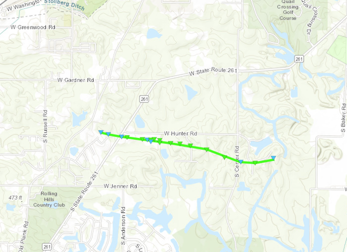
0446 AM     Tornado          6 NNW Goreville         37.64N 89.00W
04/02/2024                   Williamson         IL   NWS Storm Survey

            An EF-2 tornado impacted the Lake Of Egypt
            community in the early morning hours of
            Tuesday, April 2. The tornado began along
            Highway 148, just west of Interstate 57.
            After crossing Highway 37 east of Interstate
            57, the tornado passed along Lake of Egypt
            Road. The most severe damage occurred near
            the intersection of Lake of Egypt Road and
            Market Road, where severe roof and
            structural damage occurred to three
            businesses. The Lake of Egypt Fire
            Protection building nearby had one of its
            windows blown out. Paralleling Kimmel
            Orchard Road, the tornado did damage to
            homes and outbuildings before lifting just
            to the west of Wagon Creek Road. Hundreds of
            trees were uprooted, snapped at the base, or
            suffered damage to large limbs along the
            path.

0446 AM     Tstm Wnd Dmg     5 N Goreville           37.63N 89.00W
04/02/2024                   Williamson         IL   Trained Spotter

            Several mature trees blown over or snapped.
            Possible tornado.

0449 AM     Tstm Wnd Dmg     Goreville               37.56N 88.97W
04/02/2024                   Johnson            IL   Broadcast Media

            Newly constructed pole barn blown down in
            Goreville.

0450 AM     Tstm Wnd Dmg     5 W Creal Springs       37.63N 88.92W
04/02/2024                   Williamson         IL   Trained Spotter

            Two large trees down, including an uprooted
            oak tree and a pine tree snapped.

0450 AM     Tstm Wnd Gst     3 WSW Mound City        37.07N 89.22W
04/02/2024  M58 MPH          Alexander          IL   AWOS

            AWOS station KCIR Cairo IL.

0450 AM     Tstm Wnd Dmg     5 W Creal Springs       37.61N 88.92W
04/02/2024                   Williamson         IL   Trained Spotter

            Corrects previous tornado report from 5 W
            Creal Springs. Sporadic trees and power
            poles snapped in the North Shoreland
            Subdivision.

0453 AM     Tstm Wnd Gst     3 WNW Scott City        37.23N 89.58W
04/02/2024  M64 MPH          Scott              MO   ASOS

            ASOS station KCGI Cape Girardeau MO.

0455 AM     Tstm Wnd Dmg     5 NE Creal Springs      37.69N 88.81W
04/02/2024                   Williamson         IL   Trained Spotter

            Roof damage to outbuildings, tree snapped,
            and boat blown around.

0455 AM     Tstm Wnd Dmg     Creal Springs           37.63N 88.84W
04/02/2024                   Williamson         IL   Emergency Mngr

            High winds reported. Power out in rural
            area.
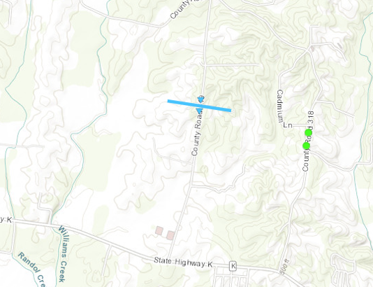
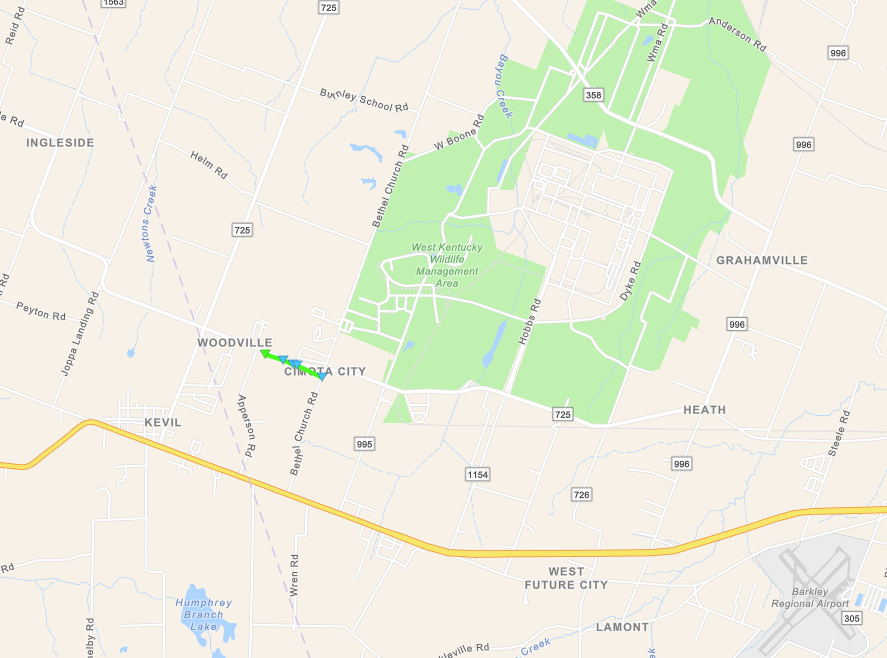
0456 AM     Tornado          1 ENE Creal Springs     37.62N 88.82W
04/02/2024                   Williamson         IL   NWS Storm Survey

            An EF-1 tornado impacted the Stonefort
            community during the early morning hours of
            Tuesday, April 2. The tornado began just
            east of Creal Springs along Saltpetre Road.
            Damage was mainly to trees as the tornado
            moved parallel to Pleasant Valley Road. The
            tornado moved directly through the community
            of Stonefort, causing extensive tree damage.
            Most damage to buildings was caused by trees
            falling onto the building. However, a couple
            of homes had portions of their roofs
            removed. The tornado continued east into
            Saline County for about one mile, lifting
            near the crossing of Battleford Road and the
            Illinois Central Railway.

0457 AM     Tstm Wnd Dmg     1 E Creal Springs       37.62N 88.82W
04/02/2024                   Williamson         IL   Emergency Mngr

            Widespread tree/powerline damage. More
            significant structural damage near Lake of
            Egypt and east to Stonefort. Radar indicated
            TDS in this area.

0502 AM     Tstm Wnd Dmg     5 SE Stonefort          37.56N 88.66W
04/02/2024                   Pope               IL   Trained Spotter

            Large trees down.

0503 AM     Tstm Wnd Dmg     Heath                   37.09N 88.79W
04/02/2024                   McCracken          KY   Emergency Mngr

            Carports blown off a building, other roof
            damage. Trees and powerlines down in the
            Heath and Woodville Rd. area.

0505 AM     Tornado          1 NE Kevil              37.09N 88.87W
04/02/2024                   McCracken          KY   NWS Storm Survey

            A brief EF-1 tornado struck just east of the
            Woodville community in far western McCracken
            County, KY. The tornado moved parallel along
            the south side of Woodville Road. The most
            severe damage was to a house that had a
            portion of its roof removed. Another couple
            homes suffered facia and siding damage.
            About a dozen trees had large limbs downed.
            The tornado path was about 0.6 mile in
            length with an estimated maximum width of 50
            yards.

0511 AM     Tstm Wnd Dmg     5 S Harrisburg          37.67N 88.54W
04/02/2024                   Saline             IL   Public

            Trees snapped at the ground.

0513 AM     Tstm Wnd Dmg     2 ESE Eldorado          37.80N 88.40W
04/02/2024                   Saline             IL   Public

            Possible tornado. Several out buildings
            destroyed. Home severely damaged. Powerlines
            down.
0515 AM     Tornado          2 ESE Eldorado          37.79N 88.40W
04/02/2024                   Saline             IL   Public

            *** 2 INJ ***
            An EF-2 tornado occurred approximately two
            miles southeast of Eldorado during the early
            morning hours of Tuesday, April 8th. The
            tornado began near the Intersection of
            Highway 142 and Ridgway Road. Here, the
            tornado destroyed an outbuilding, uprooted
            several large trees, and removed portions of
            the roofs of two homes. Crossing Ridgway
            Road and the intersection of White Road, the
            tornado severely damaged an industrial
            garage and two manufactured homes. One
            manufactured home was moved several feet off
            its foundation and had one of its walls torn
            open. Two occupants of the home suffered
            laceration injuries due to flying debris.
            About five large hardwood trees just behind
            this home were all snapped at the base.
            Moving east-southeast, the tornado lifted
            near Dusty Road just south of Ridgway Road.

0521 AM     Tornado          1 W Ridgway             37.80N 88.27W
04/02/2024                   Gallatin           IL   NWS Storm Survey

            A brief EF-1 tornado impacted the west side
            of Ridgway, IL, during the early morning
            hours of Tuesday, April 2. The tornado began
            just south of Main Street along St. Joseph
            Road, where one home suffered minor roof
            damage and several large tree limbs were
            downed. Moving northeast, the tornado
            damaged a grain bin just south of Main
            Street and damaged the roof of an
            outbuilding just north of Main Street. The
            tornado did limited tree damage in the city
            park before lifting near the intersection of
            City Park Drive and Murphy Street.
0522 AM     Tornado          5 W New Haven           37.89N 88.21W
04/02/2024                   Gallatin           IL   Public

            An EF-1 tornado impacted far northeast
            Gallatin County, IL, and extreme southwest
            Posey County, IN, during the early morning
            hours of Tuesday, April 2. The tornado began
            in the Cottonwood community along Noel Road.
            Here several large trees were uprooted, one
            crushing a small brick building. One
            manufactured home was severely damaged and a
            nearby outbuilding had a part of its roof
            removed. Moving eastward the tornado did
            mainly tree damage as passed south of the
            community of New Haven. The tornado lifted
            shortly after crossing the Wabash River in
            Posey County, IN, just south of the
            confluence of the Little Wabash and Wabash
            Rivers.

0523 AM     Tstm Wnd Dmg     1 N Ridgway             37.81N 88.26W
04/02/2024                   Gallatin           IL   Emergency Mngr

            Grain bin blown into the roadway near
            Ridgway.

0524 AM     Tstm Wnd Dmg     Grayville               38.27N 88.00W
04/02/2024                   Edwards            IL   Public

            Large tree snapped at the base. Relayed via
            Facebook.
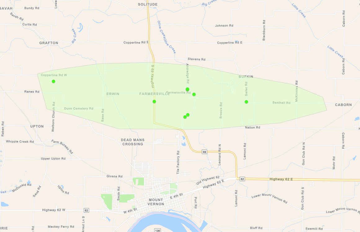
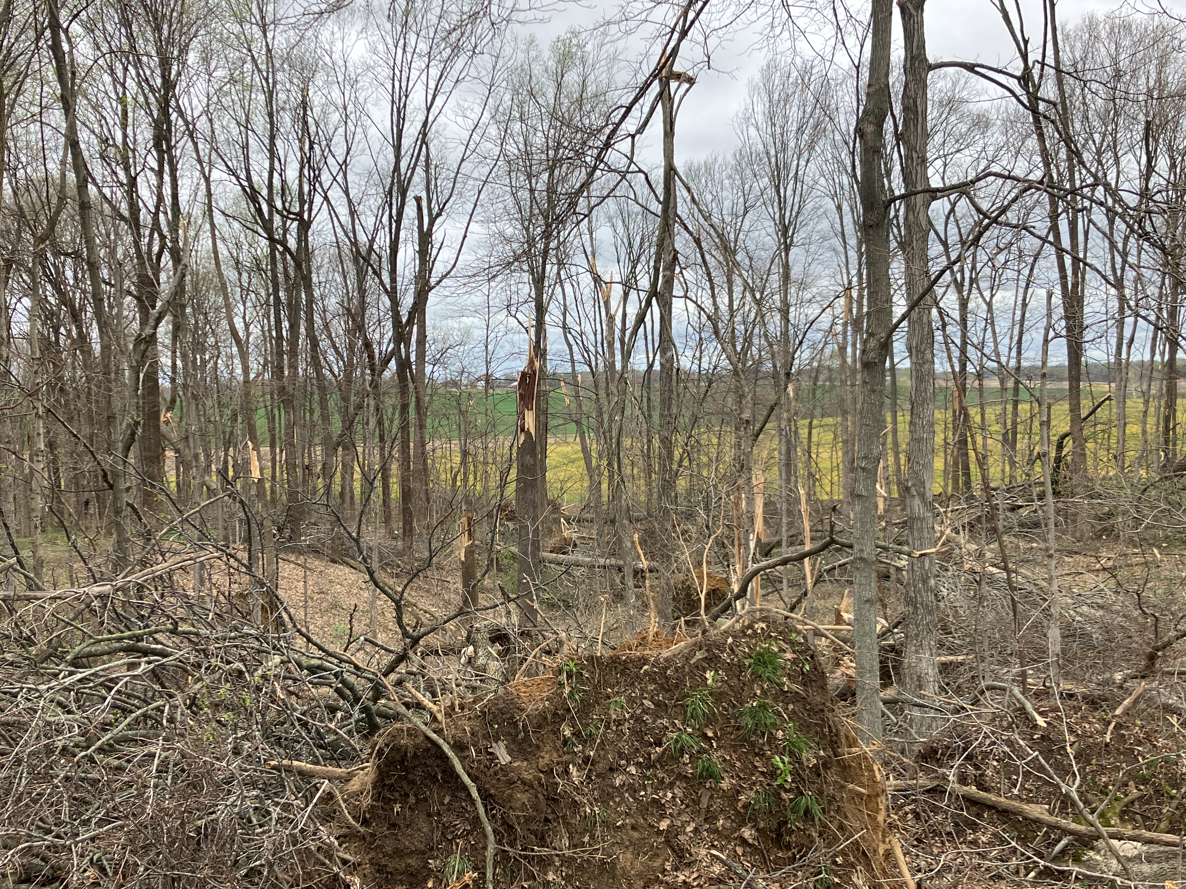
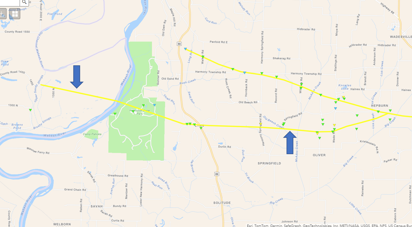
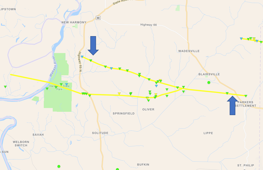
0531 AM     Tornado          3 NNE Maunie            38.07N 88.02W
04/02/2024                   White              IL   NWS Storm Survey

            Hundreds of trees uprooted or snapped.
            Several outbuildings/sheds were damaged or
            destroyed. Minor to moderate roof damage to
            several homes. Path started just west of the
            Wabash River in White County Illinois.
            Crossed through Harmonie State Park and
            across Hwy 69. This tornado eventually
            merged with another tornado west- southwest
            of the town of Blairsville. Peak wind was
            115 mph (EF-2) and max width was 250 yards.

0535 AM     Tstm Wnd Dmg     5 E Maunie              38.01N 87.97W
04/02/2024                   Posey              IN   Trained Spotter

            Barns and sheds destroyed. Possible tornado.

0536 AM     Tstm Wnd Dmg     7 NW Mount Vernon       38.02N 87.98W
04/02/2024                   Posey              IN   Public

            Large pole barn destroyed. Relayed via
            Facebook.
0537 AM     Tornado          2 SSE New Harmony       38.10N 87.91W
04/02/2024                   Posey              IN   NWS Storm Survey

            EF-2 Tornado. Hundreds of trees were snapped
            or uprooted. Dozens of outbuildings were
            damaged or destroyed. Minor to moderate
            damage to several homes. This path started
            just east of Hwy 69 near Harmony Township
            Road and tracked southeast, eventually
            merging with another tornado west-southwest
            of the town of Blairsville. It lifted
            several miles southeast of Blairsville in
            extreme eastern Posey County. While the
            tornado lifted, straight-line wind damage
            continued into Vanderburgh County on the
            north side of Evansville.

0539 AM     Tstm Wnd Dmg     Uniontown               37.78N 87.93W
04/02/2024                   Union              KY   Emergency Mngr

            *** 1 INJ ***
            Mobile home destroyed by tree. One minor
            injury. Additional damage in Sullivan.

0540 AM     Tstm Wnd Dmg     3 NE Mount Vernon       37.97N 87.87W
04/02/2024                   Posey              IN   Public

            Severe damage to a barn, including a
            destroyed wall and roof removed. Debris
            thrown about 100 feet away from the
            structure. Possible tornado.

0541 AM     Tstm Wnd Dmg     3 NE Mount Vernon       37.98N 87.87W
04/02/2024                   Posey              IN   Public

            Several trees uprooted and snapped. Damage
            to structures in the area. Possible tornado.

0542 AM     Tstm Wnd Dmg     7 SE New Harmony        38.07N 87.83W
04/02/2024                   Posey              IN   Public

            Corrects previous tornado report from 7 SE
            New Harmony. Severe tree damage in a
            concentrated path. Possible tornado.

0542 AM     Tstm Wnd Dmg     7 S Poseyville          38.06N 87.80W
04/02/2024                   Posey              IN   Public

            Severe tree damage in a concentrated path.
            Possible tornado.

0543 AM     Tstm Wnd Dmg     8 S Poseyville          38.06N 87.74W
04/02/2024                   Posey              IN   Public

            Significant tree damage reported. Possible
            tornado.

0545 AM     Tstm Wnd Dmg     8 S Poseyville          38.06N 87.74W
04/02/2024                   Posey              IN   Public

            Heavy concentrated tree damage path.
            Possible tornado.

0547 AM     Tstm Wnd Dmg     8 W Darmstadt           38.05N 87.72W
04/02/2024                   Posey              IN   Public

            Trees downed and snapped. Shingle damage to
            a house. Fences blown down.

0547 AM     Tstm Wnd Dmg     5 S Cynthiana           38.11N 87.71W
04/02/2024                   Posey              IN   Public

            Severe roof damage to a house. House is not
            habitable. Possible tornado.
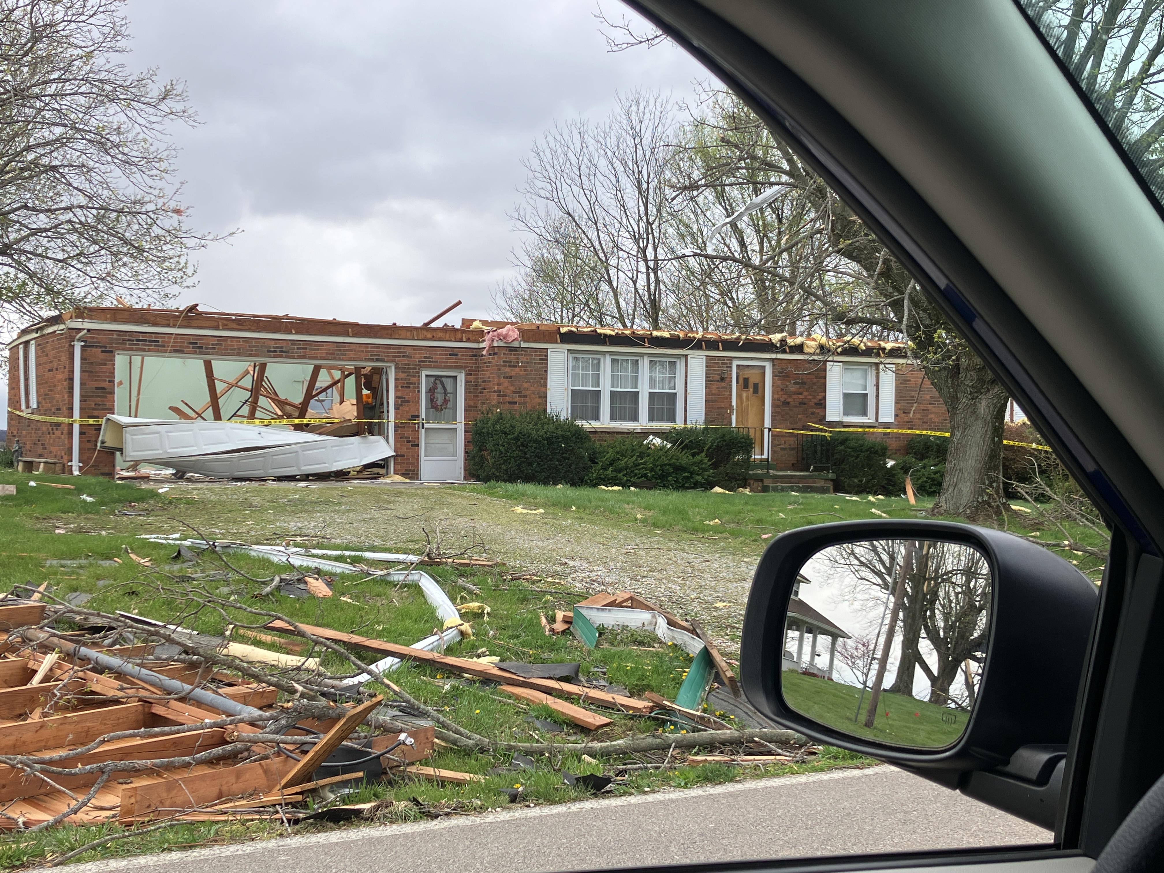
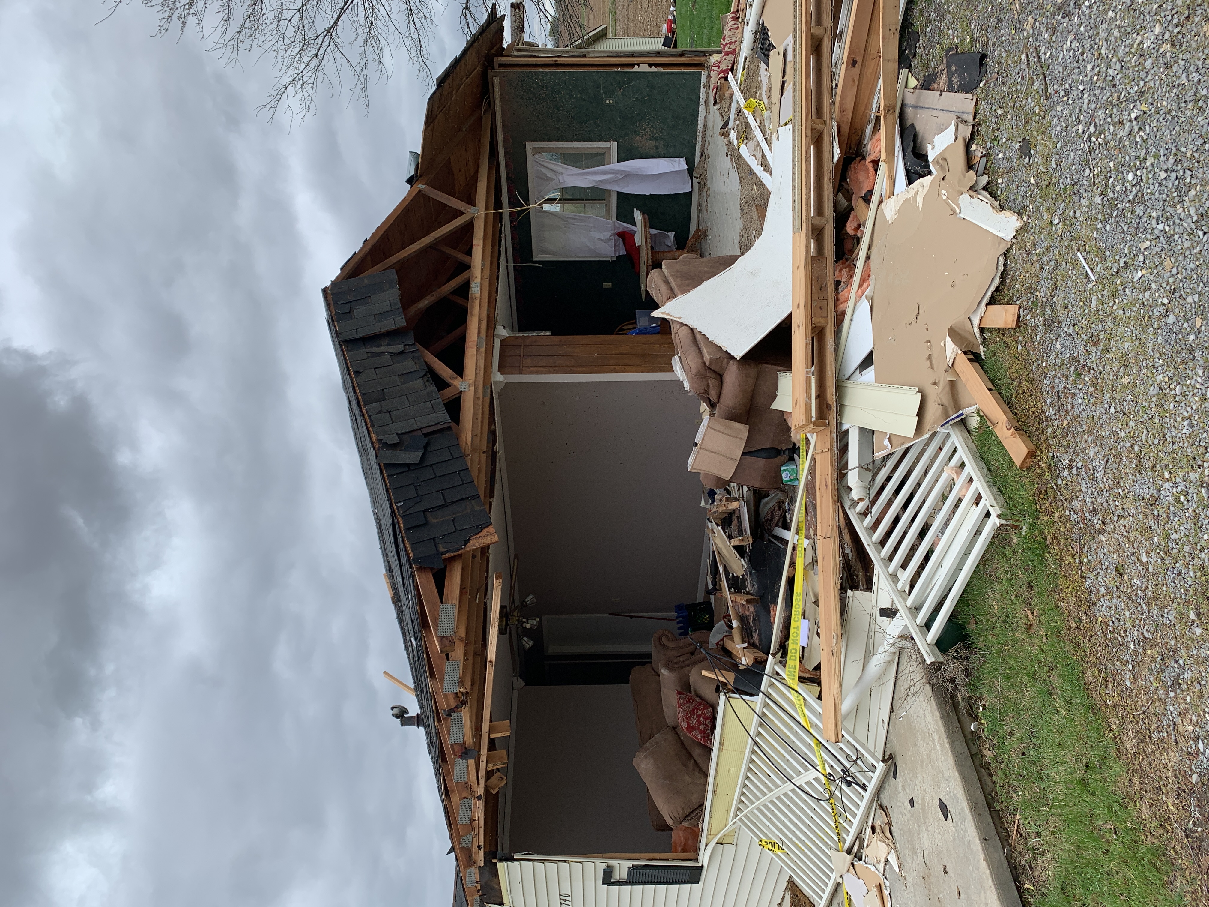
0547 PM     Tornado          5 S Cynthiana           38.12N 87.72W
04/02/2024                   Posey              IN   NWS Storm Survey

            EF-2 Tornado. This tornado started in far
            eastern Posey County just northwest of St
            Wendel. It then moved east southeast across
            the entire width of Vanderburgh County
            before lifting in far western Warrick County
            to the east of I-69 near the intersection of
            Kansas Road and Euler Road. The most
            significant damage occurred in the St Wendel
            area where several homes had their entire
            roof removed. Minor structural damage
            occurred to a few homes in the Hillsdale
            area near Hwy 41. Numerous outbuildings or
            sheds were damaged or destroyed along the
            path. There were hundreds of trees that were
            snapped or uprooted as well.
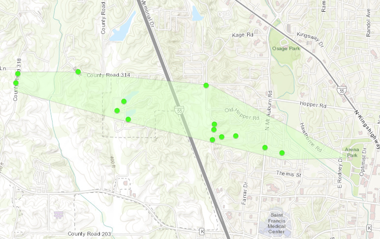
0548 AM     Tornado          3 SE Cynthiana          38.15N 87.67W
04/02/2024                   Vanderburgh        IN   NWS Storm Survey

            EF-2 Tornado. Hundreds of trees were snapped
            or uprooted. Dozens of outbuildings were
            damaged or destroyed. Minor to moderate
            damage to several homes. Electrical power
            poles were snapped. This path started just
            south of I-64 along Hwy 65 in far northwest
            Vanderburgh County. It then tracked
            east-southeast across Hwy 41 and I-69.
            Another tornado merged with it a few miles
            south of Elberfeld in northwest Warrick
            County and then the tornado dissipated
            shortly after. Path length was 14.2 miles
            and max width was 200 yards. Peak winds were
            115 mph.

0549 AM     Tstm Wnd Dmg     4 SE Cynthiana          38.15N 87.66W
04/02/2024                   Vanderburgh        IN   Public

            Corrects previous tornado report from 4 SE
            Cynthiana. Severe damage to a house.
            Possible tornado.

0549 AM     Tstm Wnd Dmg     3 W Darmstadt           38.09N 87.63W
04/02/2024                   Vanderburgh        IN   Public

            Several evergreen trees down across a wide
            area. Additional trees with large limbs
            down. Power lines down.

0549 AM     Tstm Wnd Dmg     8 W Darmstadt           38.05N 87.71W
04/02/2024                   Posey              IN   Public

            Several trees snapped with their trunks
            twisted. East-facing part of a barn roof
            removed. Possible tornado.

0550 AM     Tstm Wnd Dmg     6 SW Darmstadt          38.04N 87.68W
04/02/2024                   Vanderburgh        IN   Public

            Damage to the Town and Country Mobile Home
            Court, including several trees snapped and
            uprooted, siding and skirting pulled off
            homes, and awnings blown hundreds of feet.
            Possible tornado.

0553 AM     Tstm Wnd Dmg     3 NW Evansville         38.02N 87.58W
04/02/2024                   Vanderburgh        IN   Public

            Large tree uprooted and fell on a car.
            Significant shingle damage.

0553 AM     Tstm Wnd Dmg     3 N Darmstadt           38.13N 87.57W
04/02/2024                   Vanderburgh        IN   Public

            Corrects previous tornado report from 3 N
            Darmstadt. Several trees uprooted. Roof to a
            garage and home damaged. Pole barn severely
            damage. Possible tornado.

0553 AM     Tstm Wnd Dmg     4 NW Evansville         38.03N 87.59W
04/02/2024                   Vanderburgh        IN   Public

            Corrects previous tornado report from 4 NW
            Evansville. Significant shingle damage to a
            house.
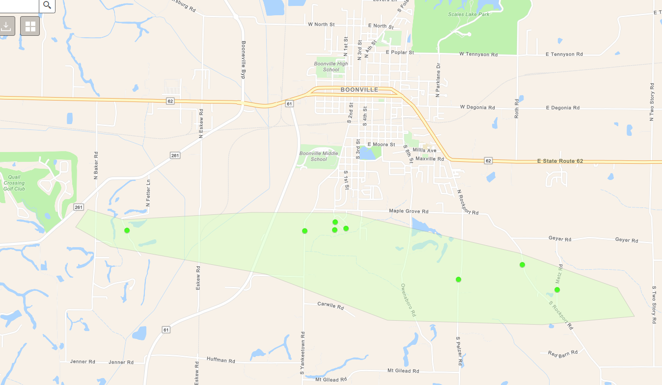
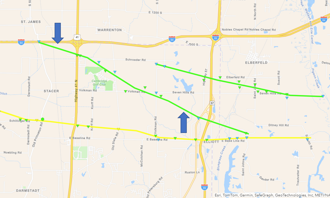
0554 AM     Tornado          2 S Haubstadt           38.17N 87.57W
04/02/2024                   Gibson             IN   NWS Storm Survey

            EF-1 Tornado. Dozens of trees were snapped
            or uprooted. Several outbuildings were
            damaged or destroyed. Minor to moderate
            damage to a few homes. This path started
            along I-64 just west of exit 25. It then
            tracked southwest just on the outskirts of
            the Cambridge Golf Club. It crossed Volkman
            Road and continued southeast crossing I-69
            before merging with another tornado a few
            miles south of Elberfeld in far northwest
            Warrick County. Path length was 7.3 miles
            and max width was 200 yards. Peak winds were
            100 mph.

0554 AM     Tstm Wnd Dmg     3 W Melody Hill         38.04N 87.56W
04/02/2024                   Vanderburgh        IN   Public

            Two large trees uprooted.

0554 AM     Tstm Wnd Dmg     1 SSE Darmstadt         38.08N 87.57W
04/02/2024                   Vanderburgh        IN   Trained Spotter

            HAM radio operator/trained spotter reports
            power pole down, several trees topped and 3
            trees uprooted.

0555 AM     Tstm Wnd Dmg     3 NW Evansville         38.02N 87.57W
04/02/2024                   Vanderburgh        IN   Public

            Fence blown down and shed moved by high
            winds.

0555 AM     Tstm Wnd Dmg     2 E Darmstadt           38.08N 87.54W
04/02/2024                   Vanderburgh        IN   Public

            Extensive and severe tree damage. Several
            tall poplar trees snapped. Some nearby trees
            fell onto homes. Possible tornado.

0557 AM     Tstm Wnd Dmg     2 WSW Evansville        37.98N 87.57W
04/02/2024                   Vanderburgh        IN   Emergency Mngr

            70 mph wind gust measured at
            Evansville/Vanderburgh EOC. Roof damage to
            EOC. Numerous reports of trees and
            powerlines down and damage to mobile homes
            throughout Vanderburgh County.

0557 AM     Tstm Wnd Dmg     1 NE Evansville         37.99N 87.53W
04/02/2024                   Vanderburgh        IN   Public

            Small metal storage barn blown over. Fences
            blown down.

0557 AM     Tstm Wnd Dmg     Melody Hill             38.03N 87.51W
04/02/2024                   Vanderburgh        IN   Public

            Large tree down as well as numerous large
            branches. Fence also blown down.

0557 AM     Tstm Wnd Dmg     1 E Evansville          37.99N 87.52W
04/02/2024                   Vanderburgh        IN   Public

            Eight inch tree limb down.
0558 AM     Tornado          3 W Elberfeld           38.16N 87.51W
04/02/2024                   Vanderburgh        IN   NWS Storm Survey

            EF-1 Tornado. One home suffered minor roof
            damage. Several outbuildings were damaged or
            destroyed. Dozens of trees were snapped or
            uprooted. Tornado touched down just
            southwest of the I-69 and I-64 interchange
            and continued east-southeast across I-69. It
            lifted near the intersection of Seven Hills
            Road and Schultz Road about 1.5 miles
            southeast of Elberfeld.

0558 AM     Tstm Wnd Dmg     2 E Melody Hill         38.04N 87.48W
04/02/2024                   Vanderburgh        IN   Public

            Large tree limbs down. Camper pushed then
            rolled over. Metal shed wall damaged.

0600 AM     Tstm Wnd Dmg     5 NNE Melody Hill       38.09N 87.48W
04/02/2024                   Vanderburgh        IN   Public

            Billboard damaged at Hwy 57 and I-69 exit.

0600 AM     Tstm Wnd Dmg     4 NNE Melody Hill       38.08N 87.48W
04/02/2024                   Vanderburgh        IN   Fire Dept/Rescue

            Power poles snapped along I-69 South of
            Boonville New Harmony road.

0602 AM     Tstm Wnd Dmg     3 N Newburgh            37.99N 87.39W
04/02/2024                   Warrick            IN   Public

            Large pine tree with limbs down, damaging a
            fence.

0603 AM     Tstm Wnd Dmg     Elberfeld               38.17N 87.45W
04/02/2024                   Warrick            IN   Broadcast Media

            2 semis blown of the road near the
            intersection of I-69 and I-64.

0605 AM     Tstm Wnd Gst     3 NE Melody Hill        38.06N 87.48W
04/02/2024  M84 MPH          Vanderburgh        IN   Mesonet

            Mesonet station IN016 1.2 NE Melody Hill
            (INDOT).

0605 AM     Tstm Wnd Dmg     3 SE Chandler           38.02N 87.33W
04/02/2024                   Warrick            IN   Public

            Several trees downed in the neighborhood and
            a destroyed shed.
0606 AM     Tornado          4 S Lynnville           38.14N 87.32W
04/02/2024                   Warrick            IN   NWS Storm Survey

            EF-1 Tornado. Tornado followed Turpin Hill
            Road and crossed over Hwy 61 north of
            Greenbrier. It then made a jog southeast and
            went along Folsomville Road, which is where
            significant shingle damage occurred to a
            home and a large barn was destroyed. A few
            other homes observed minor damage. Dozens of
            trees were snapped or uprooted.

0610 AM     Tstm Wnd Dmg     Boonville               38.04N 87.27W
04/02/2024                   Warrick            IN   Public

            Carport destroyed and damage to a house.

0610 AM     Tstm Wnd Dmg     1 S Boonville           38.03N 87.28W
04/02/2024                   Warrick            IN   CO-OP Observer

            Significant amount of damage in southern
            Boonville. Trees down, roof damage, and some
            structural damage.

0610 AM     Tstm Wnd Dmg     2 S Boonville           38.01N 87.26W
04/02/2024                   Warrick            IN   Public

            Several trees uprooted and snapped.

0611 AM     Tstm Wnd Dmg     5 NE Boonville          38.10N 87.22W
04/02/2024                   Warrick            IN   Public

            Trees tops removed.

0611 AM     Tstm Wnd Dmg     3 NW Tennyson           38.11N 87.15W
04/02/2024                   Warrick            IN   Public

            Large tree limbs down. Relayed via Facebook.

0611 AM     Tstm Wnd Dmg     4 NNE Boonville         38.11N 87.25W
04/02/2024                   Warrick            IN   Public

            Large tree uprooted. Relayed via Facebook.

0612 AM     Tstm Wnd Dmg     5 SE Boonville          38.01N 87.20W
04/02/2024                   Warrick            IN   Public

            Greenhouse knocked down. Measured wind gusts
            of 54 mph.

0615 AM     Tstm Wnd Gst     1 N Boonville           38.05N 87.28W
04/02/2024  M58 MPH          Warrick            IN   Emergency Mngr

            Measured on SE side of Boonville.

0615 AM     Tstm Wnd Dmg     3 N Tennyson            38.12N 87.12W
04/02/2024                   Warrick            IN   Emergency Mngr

            Tin roof ripped off barn, numerous trees
            down on roads, power poles also
            down...report from public called in to EMA.

0620 AM     Tstm Wnd Dmg     Chrisney                38.02N 87.04W
04/02/2024                   Spencer            IN   Emergency Mngr

            Utility poles snapped in Chrisney.

0626 AM     Tstm Wnd Dmg     6 NW Tennyson           38.13N 87.20W
04/02/2024                   Warrick            IN   Public

            House severely damaged by falling trees.
            Possible tornado.

1240 PM     Hail             Carterville             37.76N 89.08W
04/02/2024  E1.00 Inch       Williamson         IL   Broadcast Media

            Hail up to quarter size falling at WSIL-TV
            in Carterville.

0131 PM     Hail             Harrisburg              37.74N 88.55W
04/02/2024  M0.88 Inch       Saline             IL   Law Enforcement


0133 PM     Tstm Wnd Gst     Harrisburg              37.74N 88.55W
04/02/2024  M55 MPH          Saline             IL   Law Enforcement


0240 PM     Tstm Wnd Gst     3 ESE Evansville        37.96N 87.49W
04/02/2024  E60 MPH          Vanderburgh        IN   Trained Spotter


0335 PM     Tstm Wnd Dmg     1 SE Evansville         37.98N 87.53W
04/02/2024                   Vanderburgh        IN   Trained Spotter

            Three pine trees with snapped trunks. Wind
            speed estimated around 75 mph.

0349 PM     Tstm Wnd Dmg     2 SW Owensboro          37.74N 87.14W
04/02/2024                   Daviess            KY   Emergency Mngr

            Two trees down on homes along Scherm Road on
            the west side of Owensboro.
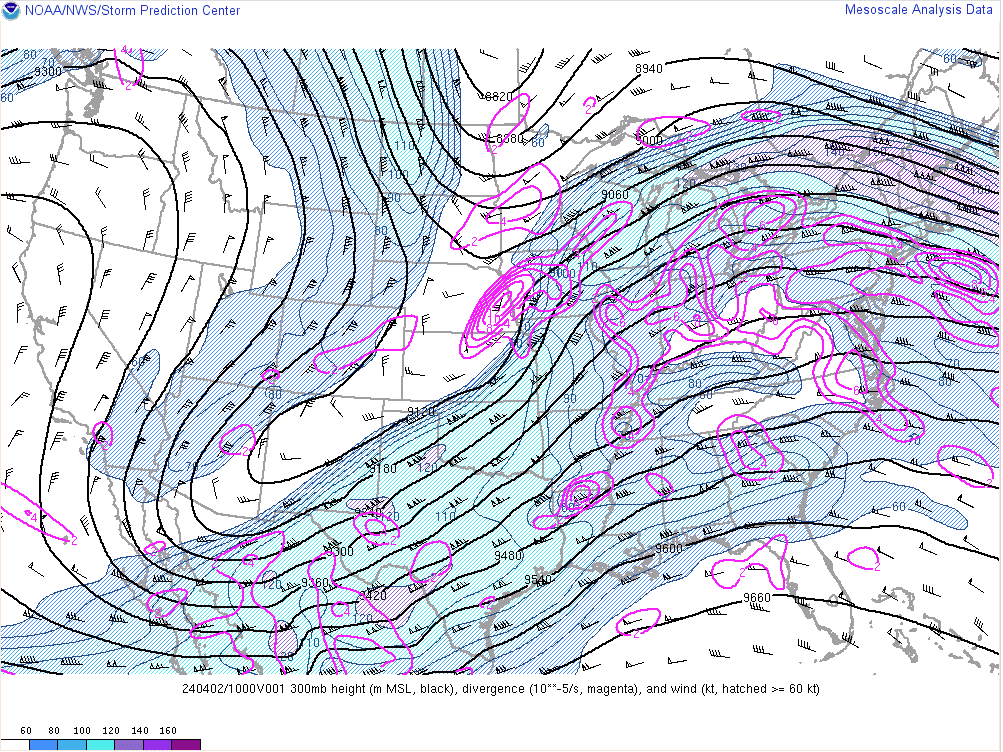
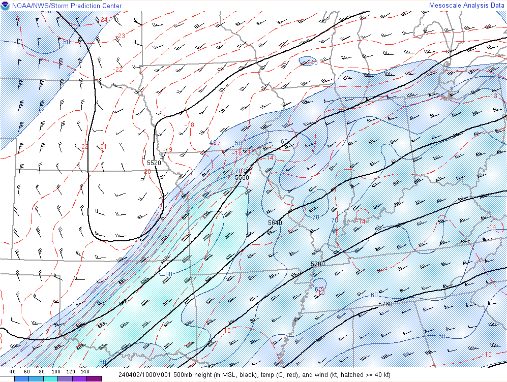
Environment
The synoptic environment was characterized by a deep mid to upper level trough ejecting across the Central Plains. Strong diffluence was present across the Ohio Valley region during the overnight and morning hours on April 2nd. The strong lift ended up winning out over the strong capping inversion (warm layer aloft) that was present during the evening prior. This had prevented convection from developing until well after midnight across most of our area. The mid-levels were characterized by a seasonably strong southwesterly 70-90 knot jet. At the surface, low pressure lifted northeast from eastern Oklahoma across central Missouri and into Illinois. This low rapidly deepened later in the day on April 2nd as it lifted toward Chicago, IL and into the Great Lakes.
 |
 |
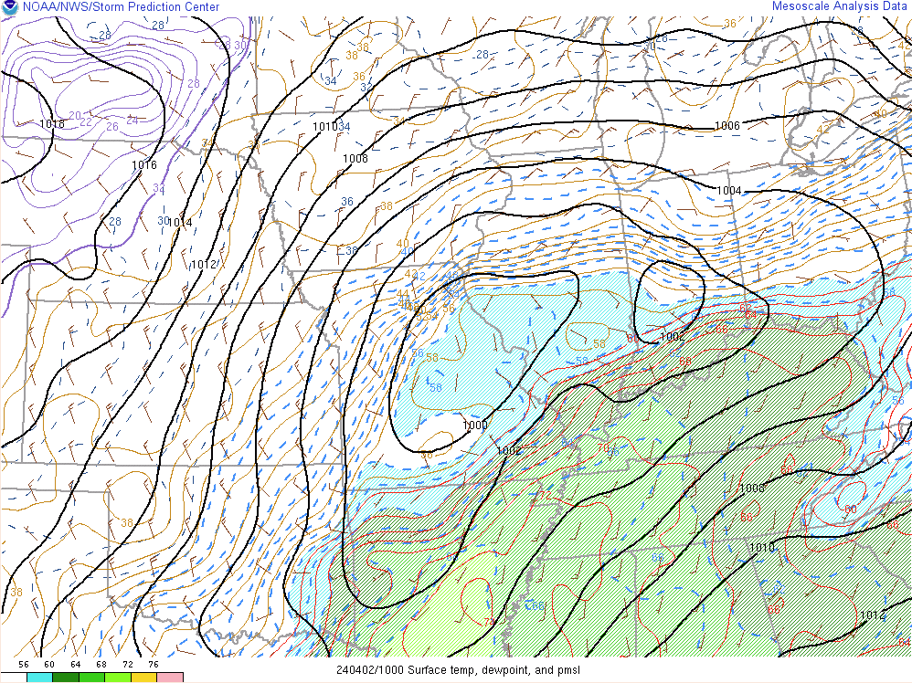 |
| 300mb chart at 5 AM April 2, 2024 | 500mb chart at 5 AM April 2, 2024 | Surface chart at 5 AM April 2, 2024 |
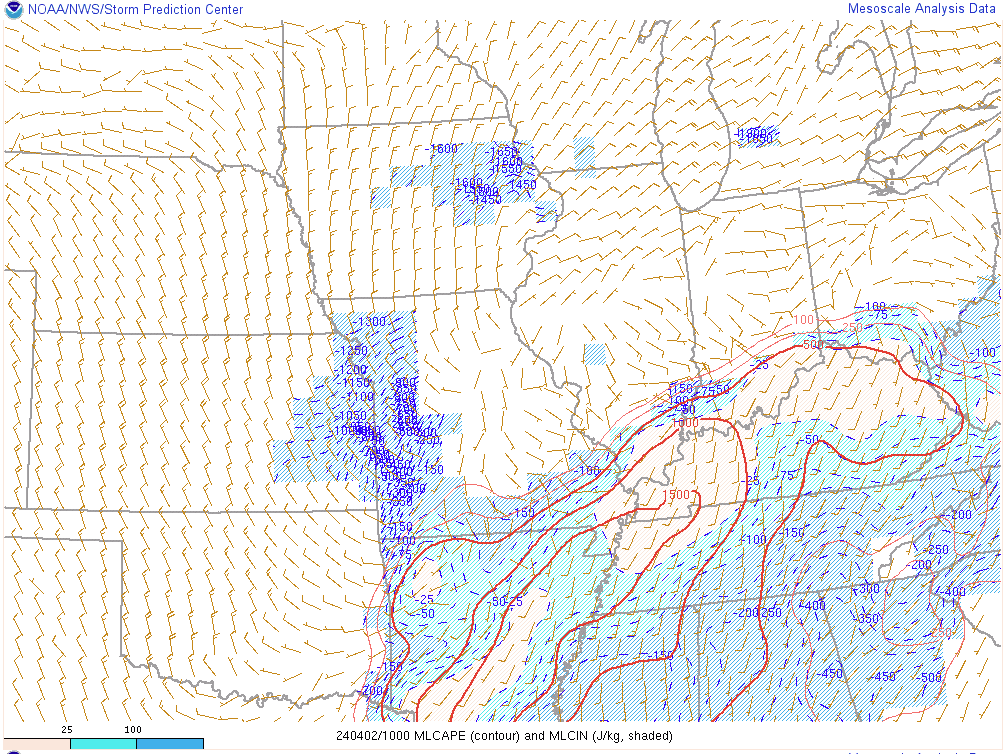
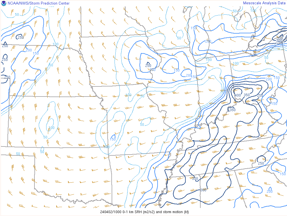
Instability increased across the region during the overnight and early morning with MLCAPE values of 1000-1500 j/kg. At the same time, we had plenty of wind shear present with 60-70 kts of effective shear across the region. In particular, the low level wind shear was quite impressive with 0-1 km values of 30-35 knots.
 |
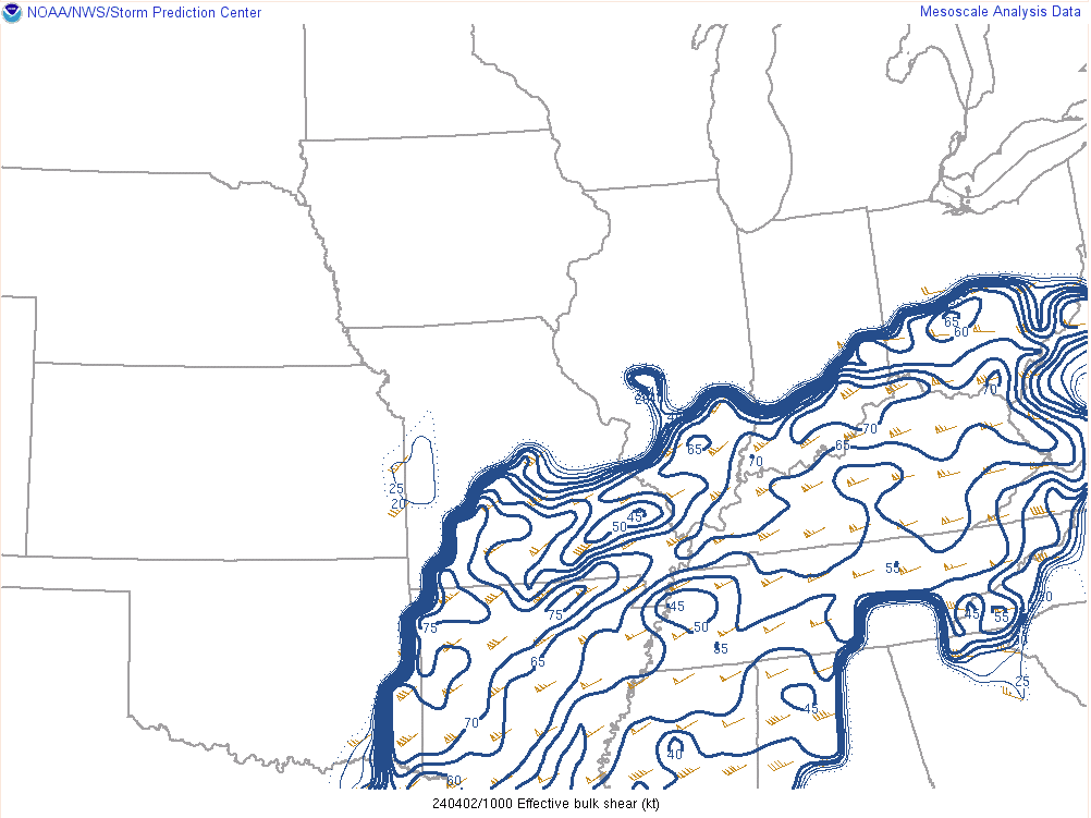 |
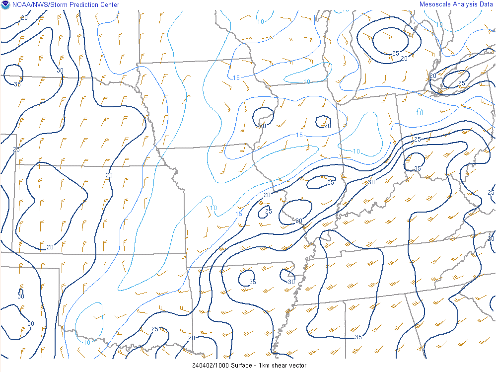 |
| Mixed-Layer CAPE at 5 AM April 2, 2024 | 0-6km effective shear at 5 AM April 2, 2024 | 0-1 km shear at 5 AM April 2, 2024 |
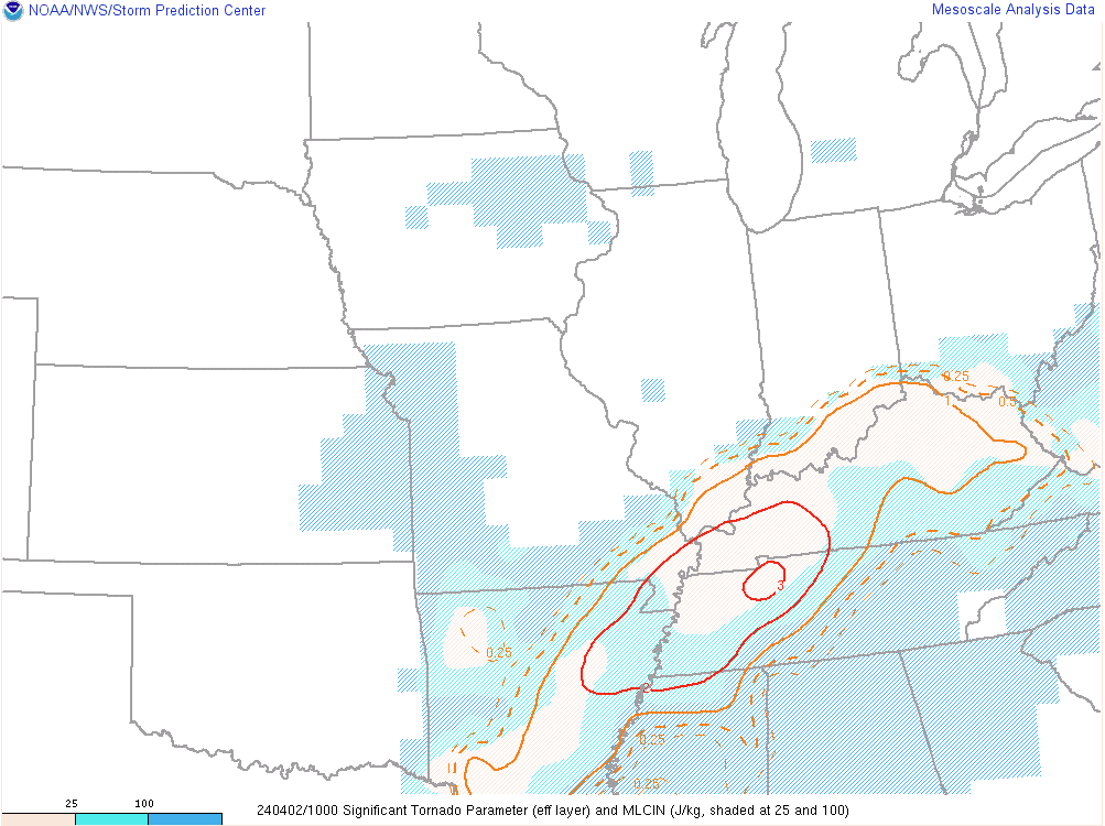
One thing we noticed was how strong the capping inversion was on the Little Rock, AR observed sounding at 7 PM on April 1st. This largely helped prevent storms from developing until well after midnight. This is when the large scale lift was able to overcome this capping inversion and lead to rapid thunderstorm develop with a very robust line of thunderstorms that formed across southeast Missouri and southwest Illinois and rapidly spread eastward across the rest of our region. Once that cap broke, the environment in place was conducive for significant thunderstorms including the risk for tornadoes.
 |
 |
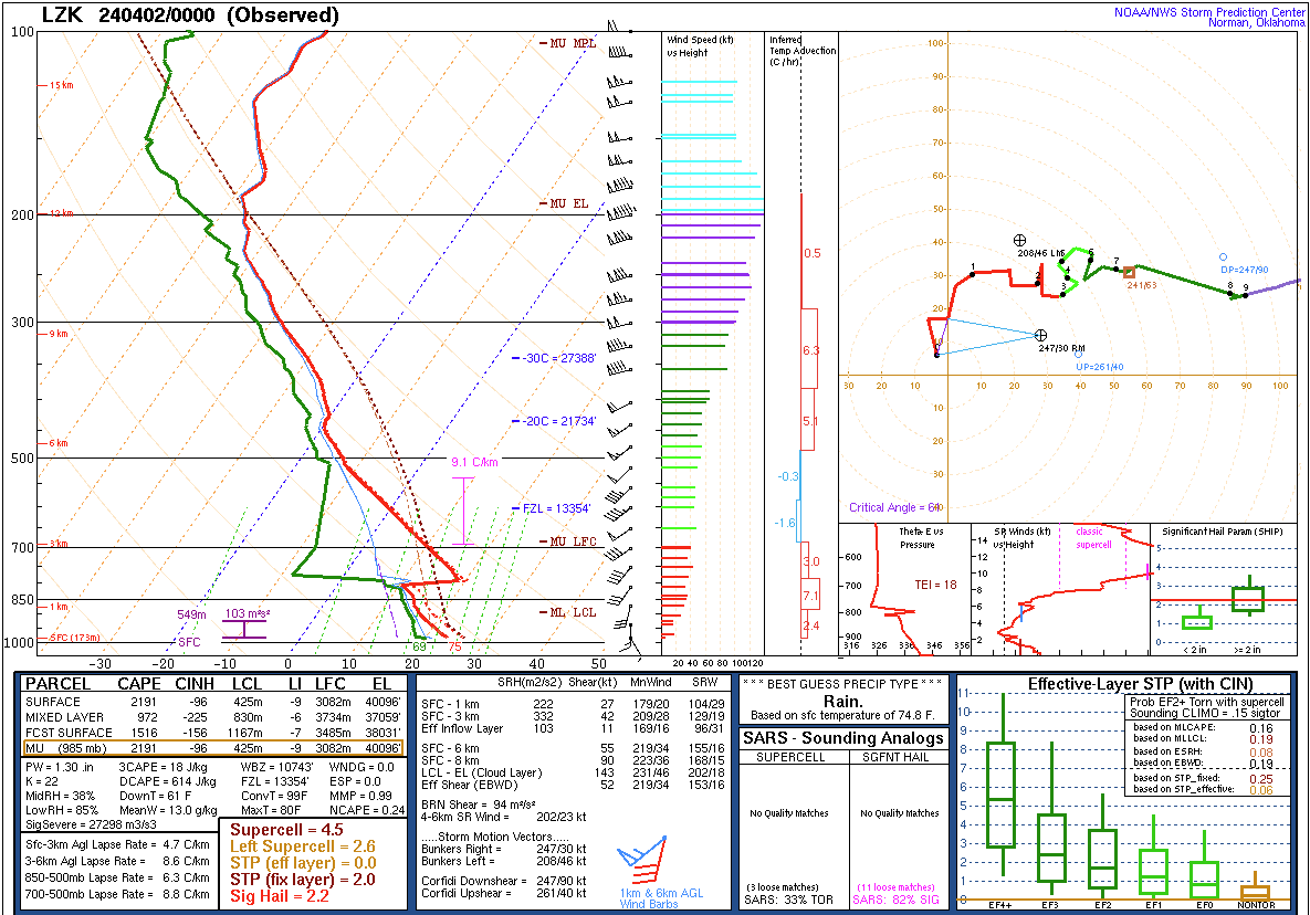 |
| Significant Tornado Parameter (STP) at 5 AM April 2, 2024 | 0-1 km Storm Relative Helicity (SRH) at 5 AM April 2, 2024 | Observed Sounding in Little Rock, AR at 7 PM April 1st |
Additional Information
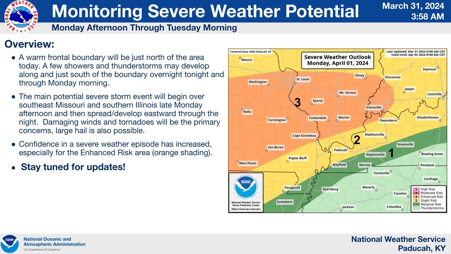
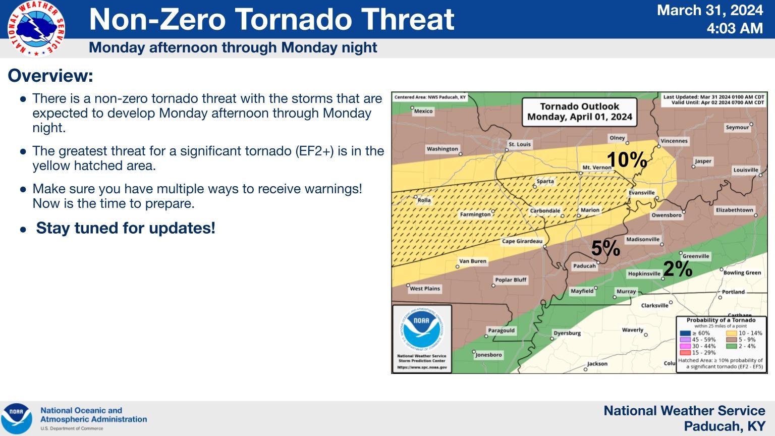
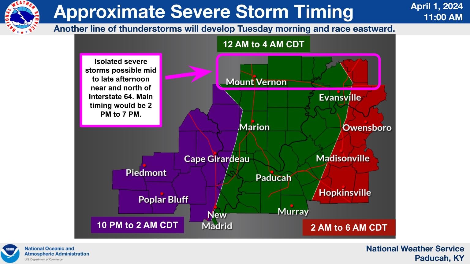
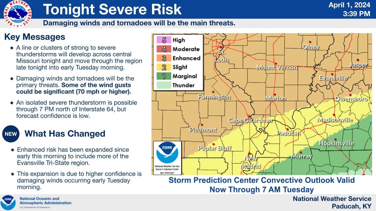
An enhanced risk (level 3 out of 5) was in effect for portions of Missouri, Illinois, and Indiana about 48 hours before the event unfolded. The tornado outlook issued at that same time indicated the was a chance for significant tornadoes (EF-2 or stronger). As the event drew closer, the enhanced risk was shifted a bit further south across more of the region. Our timing graphic indicated it would be mainly an overnight event occurring between midnight and 6 AM. This panned out well, with the worst of the storms occurring between 2 and 7 AM.
 |
 |
 |
 |
| SPC Forecast 48 hours before the event | SPC tornado forecast 48 hours before the event | Timing forecast about 18 hours before the event | SPC forecast 12 hours before the event |
 |
Media use of NWS Web News Stories is encouraged! Please acknowledge the NWS as the source of any news information accessed from this site. |
|


%20EF-2.PNG)
%20EF-1.PNG)
%20EF-2.PNG)
%20EF-1.PNG)
%20EF-1.PNG)
(1).PNG)
%20EF-2.PNG)
%20EF-1.PNG)
.PNG)
%20EF-1.PNG)
.PNG)
.PNG)
.PNG)