Overview
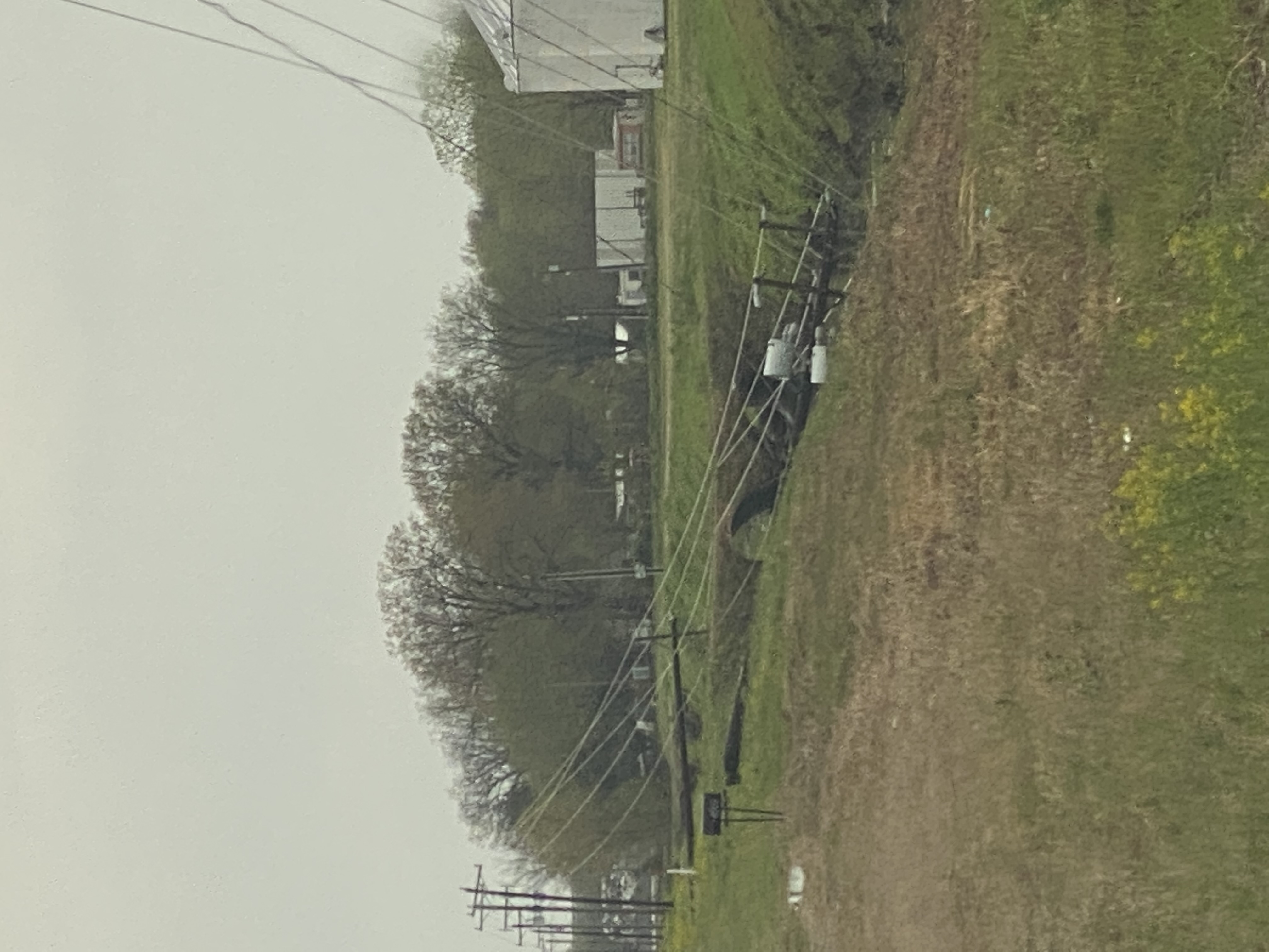
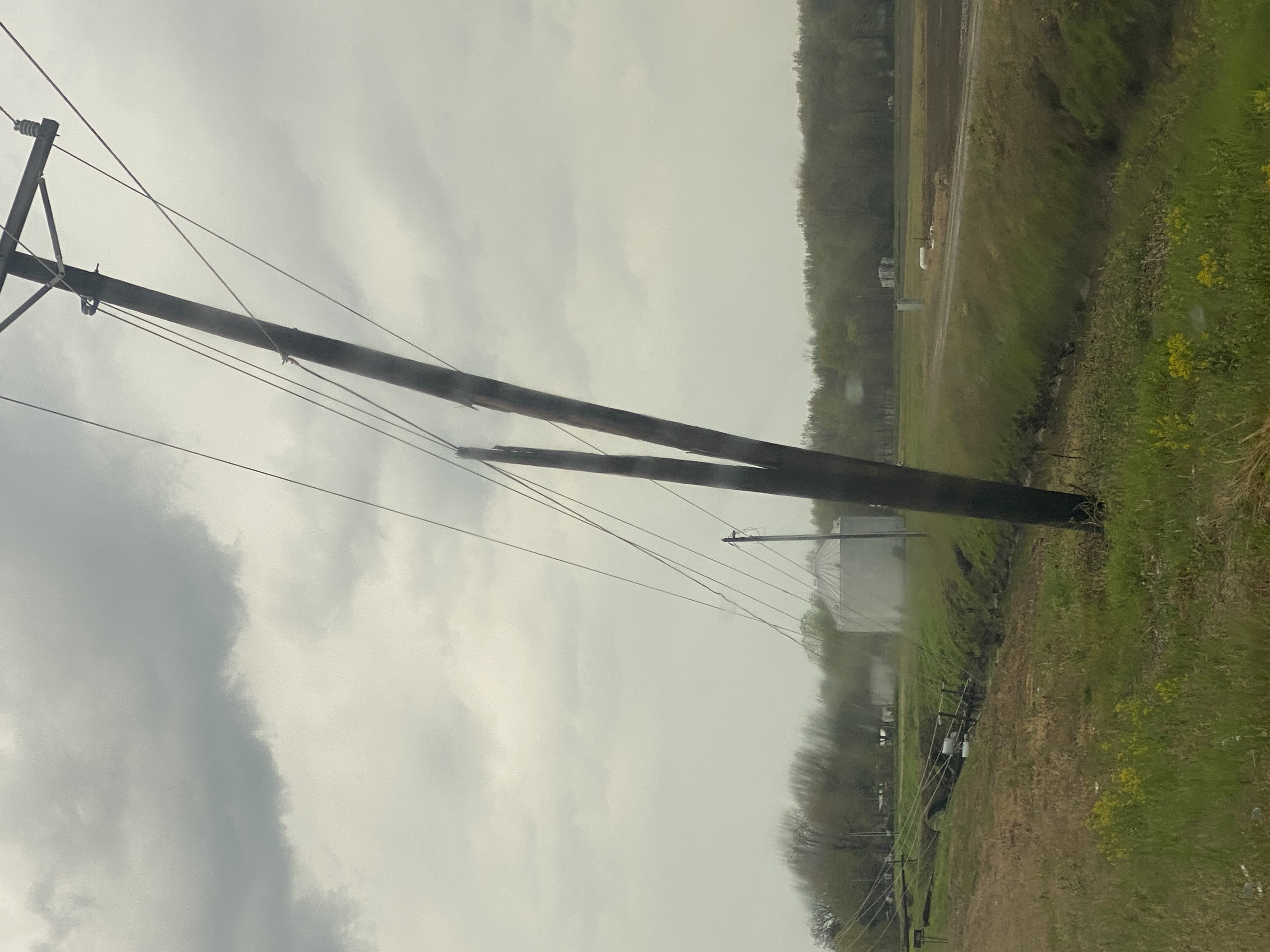
Scattered thunderstorms produced isolated large hail up to the size of golf balls, along with isolated wind damage during the afternoon and evening. Most of the reports were from southeast Missouri. Between 3:30 and 7:30 PM, approximately 23 reports of hail dime-size or larger hail or wind damage were received. The vast majority of reports were large hail.Wind & Hail:
Most severe weather reports were large hail up to golf-ball size. There were a few wind damage reports, mostly consisting of minor damage caused by 50 to 60 mph winds.
Wind
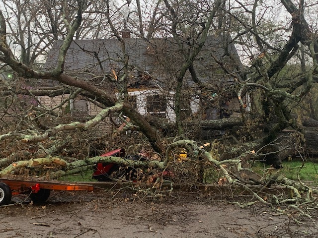
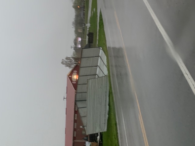
Below are photos of wind impacts in Butler County and Bollinger County, MO. Thanks to Bollinger County Emergency Management and the Poplar Bluff Severe Weather Response Team for the photos. Click on images for full size versions.
 |
 |
 |
 |
| Marble Hill, MO from Calvin Troxell | Marble Hill, MO from Calvin Troxell | 1 mile east of Poplar Bluff airport from Steven Seawright | 1 mile east of Poplar Bluff airport from Steven Seawright |
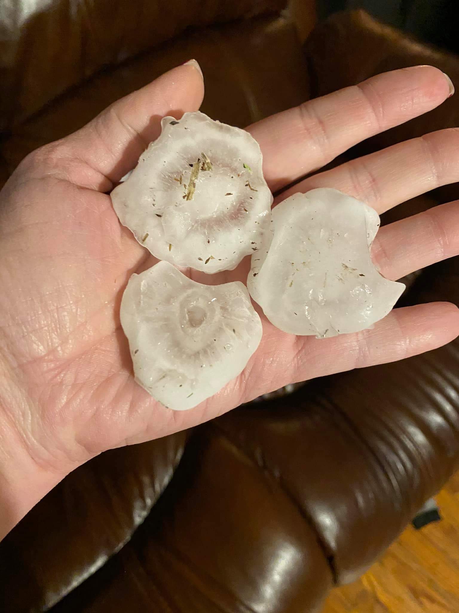
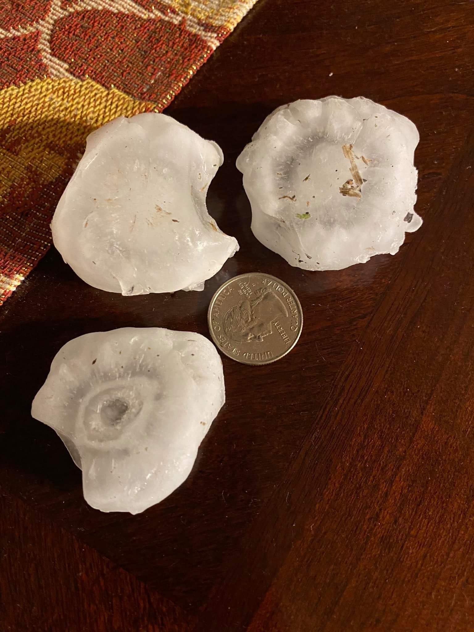
Hail
The largest hailstones documented with this event occurred in southeast Butler County, MO. Click on images for full size versions.
 |
 |
||
| Large hail in Qulin, MO from Steven Seawright | Large hail in Qulin, MO from Steven Seawright |
Storm Reports
PRELIMINARY LOCAL STORM REPORT...SUMMARY
NATIONAL WEATHER SERVICE PADUCAH KY
830 AM CDT SAT APR 10 2021

..TIME...   ...EVENT...      ...CITY LOCATION...     ...LAT.LON...
..DATE...   ....MAG....      ..COUNTY LOCATION..ST.. ...SOURCE....
            ..REMARKS..

0340 PM     HAIL             2 S GREENVILLE          37.10N 90.45W
04/09/2021  M0.70 INCH       WAYNE              MO   TRAINED SPOTTER

            NEAR CAMP ALLEN.

0351 PM     HAIL             GATEWOOD                36.58N 91.09W
04/09/2021  M0.88 INCH       RIPLEY             MO   PUBLIC

            RELAYED BY TV MEDIA.

0419 PM     HAIL             DONIPHAN                36.62N 90.82W
04/09/2021  E1.00 INCH       RIPLEY             MO   BROADCAST MEDIA

            QUARTER SIZE HAIL NEAR LONE STAR SCHOOL.

0434 PM     HAIL             DONIPHAN                36.62N 90.82W
04/09/2021  E1.50 INCH       RIPLEY             MO   BROADCAST MEDIA


0437 PM     HAIL             ELLSINORE               36.94N 90.75W
04/09/2021  E1.00 INCH       CARTER             MO   EMERGENCY MNGR

            COVERING THE GROUND.

0447 PM     HAIL             3 W ELLSINORE           36.93N 90.80W
04/09/2021  E1.00 INCH       CARTER             MO   BROADCAST MEDIA


0448 PM     HAIL             PIEDMONT                37.15N 90.70W
04/09/2021  E0.88 INCH       WAYNE              MO   BROADCAST MEDIA


0455 PM     HAIL             3 SSW PATTERSON         37.15N 90.57W
04/09/2021  E0.70 INCH       WAYNE              MO   EMERGENCY MNGR

            PEA TO DIME SIZE HAIL.

0457 PM     HAIL             PATTERSON               37.19N 90.55W
04/09/2021  E1.75 INCH       WAYNE              MO   BROADCAST MEDIA


0507 PM     HAIL             QULIN                   36.60N 90.25W
04/09/2021  E1.75 INCH       BUTLER             MO   BROADCAST MEDIA


0507 PM     HAIL             QULIN                   36.60N 90.25W
04/09/2021  E1.00 INCH       BUTLER             MO   BROADCAST MEDIA


0513 PM     HAIL             4 N QULIN               36.66N 90.25W
04/09/2021  E1.00 INCH       BUTLER             MO   BROADCAST MEDIA

            IN COMMUNITY OF BROSELEY.

0514 PM     HAIL             2 NW CHRISTOPHER        37.99N 89.08W
04/09/2021  E1.00 INCH       FRANKLIN           IL   TRAINED SPOTTER


0516 PM     HAIL             3 N MURPHYSBORO         37.81N 89.33W
04/09/2021  E0.70 INCH       JACKSON            IL   EMERGENCY MNGR


0530 PM     TSTM WND DMG     PUXICO                  36.95N 90.16W
04/09/2021                   STODDARD           MO   EMERGENCY MNGR

            POWER LINES DOWN, BLOCKING ROAD.

0530 PM     HAIL             PUXICO                  36.95N 90.16W
04/09/2021  E1.00 INCH       STODDARD           MO   BROADCAST MEDIA


0535 PM     HAIL             FISK                    36.78N 90.21W
04/09/2021  E1.00 INCH       BUTLER             MO   BROADCAST MEDIA


0543 PM     HAIL             3 W VERGENNES           37.91N 89.39W
04/09/2021  E0.70 INCH       JACKSON            IL   LAW ENFORCEMENT

            PEA TO DIME SIZE HAIL.

0610 PM     TSTM WND DMG     3 SE ZALMA              37.11N 90.04W
04/09/2021                   BOLLINGER          MO   BROADCAST MEDIA

            OLD TRAILER BLOWN ACROSS COUNTY ROAD 640
            NEAR STODDARD COUNTY LINE. TIN ROOFING BLOWN
            AROUND.

0620 PM     TSTM WND DMG     MARBLE HILL             37.30N 89.98W
04/09/2021                   BOLLINGER          MO   EMERGENCY MNGR

            CARPORT BLOWN OVER FENCE.

0620 PM     TSTM WND DMG     MARBLE HILL             37.30N 89.98W
04/09/2021                   BOLLINGER          MO   EMERGENCY MNGR

            LARGE ROTTED TREE LANDED ON A HOUSE, CAUSING
            EXTENSIVE DAMAGE. OCCURRED AT SAME TIME AND
            LOCATION AS CARPORT BLOWN OVER FENCE.

0625 PM     TSTM WND GST     CAPE GIRARDEAU          37.31N 89.55W
04/09/2021  M53 MPH          CAPE GIRARDEAU     MO   ASOS


0626 PM     FLOOD            MARION                  37.73N 88.94W
04/09/2021                   WILLIAMSON         IL   TRAINED SPOTTER

            STANDING WATER ON ROADS. A VEHICLE STOPPED
            IN FLOODWATERS.

0705 PM     TSTM WND DMG     AVA                     37.89N 89.49W
04/09/2021                   JACKSON            IL   BROADCAST MEDIA

            TWO TREES DOWN IN AVA. ONE ON A HOUSE AND
            ANOTHER ON A TRUCK. TIME ESTIMATED FROM
            RADAR.
 |
Media use of NWS Web News Stories is encouraged! Please acknowledge the NWS as the source of any news information accessed from this site. |
|

