Overview
A large ridge of high pressure aloft set up over the center of the country around August 20th and lead to a week-long heatwave across our region. High temperatures were primarily only in the low to mid 90s most days, but the main headline was the extreme humidity levels witnessed over the entirety of this event. Portions of our region experienced very heavy rainfall amounts of 15 to 25 inches from July 1st through mid August. This set the stage for record levels of evapotranspiration from the vegetation and crops. Dew points, a measure of humidity levels, were routinely in the upper 70s to lower 80s, with several locations peaking in the mid 80s. Cape Girardeau and Paducah each tied their highest dew points on record of 83 and 82 degrees respectively. This caused heat index readings to peak between 105 and 120 degrees each day from August 20th through the 25th, and continued across southwest portions of the region on the 26th. The high humidity levels also led to dense fog formation several nights during this event, which was rather unusual for a prolonged heat wave.Heat Index
The looping image below shows the highest heat index observed across our region each day from August 20th through the 26th. Further down, you will see a table with the highest values observed each day at select locations across our region. The highest reading was 130 degrees at the Perryville, MO airport. Most locations peaked between 115 and 120 degrees. There were several other sites that peaked slightly above 120 degrees though.
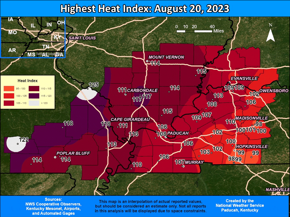 |
| Location | Provider | Aug 20 | Aug 21 | Aug 22 | Aug 23 | Aug 24 | Aug 25 | Aug 26 | Max |
| Cape Girardeau MO | ASOS | 118 | 117 | 116 | 113 | 119 | 120 | 107 | 120 |
| Carbondale IL | ASOS | 111 | 117 | 111 | 108 | 110 | 114 | 92 | 117 |
| Evansville IN | ASOS | 104 | 106 | 106 | 107 | 111 | 114 | M | 114 |
| Paducah KY | ASOS | 108 | 110 | 111 | 114 | 113 | 117 | 107 | 117 |
| Poplar Bluff MO | ASOS | 114 | 112 | 113 | 108 | 115 | 113 | 110 | 115 |
| Cairo IL | AWOS | 113 | 112 | M | M | 117 | 118 | 110 | 118 |
| Carmi IL | AWOS | 115 | 114 | 111 | 110 | 118 | 119 | 96 | 119 |
| Fort Campbell KY | AWOS | 98 | 106 | 111 | 105 | 110 | 114 | 110 | 114 |
| Greenville KY | AWOS | 100 | 106 | 108 | 105 | 111 | 114 | 98 | 114 |
| Harrisburg IL | AWOS | 114 | 118 | 116 | 116 | 117 | 124 | 101 | 124 |
| Henderson KY | AWOS | 109 | 109 | 106 | 106 | 113 | 115 | 93 | 115 |
| Hopkinsville KY 2 E | AWOS | 99 | 113 | 111 | 110 | 113 | 113 | 98 | 113 |
| Madisonville KY | AWOS | 102 | 108 | 107 | 107 | 112 | 115 | 101 | 115 |
| Marion IL | AWOS | 117 | 117 | 113 | 110 | 113 | 123 | 90 | 123 |
| Metropolis IL | AWOS | 106 | 108 | 108 | 105 | 108 | 113 | 102 | 113 |
| Mt Vernon IL | AWOS | 114 | 117 | 113 | 111 | 117 | 118 | 85 | 118 |
| Murray KY | AWOS | 111 | 113 | 117 | 113 | 120 | 124 | 117 | 124 |
| Owensboro KY | AWOS | 102 | 108 | 106 | 105 | 114 | 115 | 96 | 115 |
| Perryville MO | AWOS | 125 | 130 | 122 | 117 | 121 | 125 | 90 | 130 |
| Sikeston MO | AWOS | 113 | 115 | 113 | 113 | 118 | 115 | 113 | 118 |
| Sturgis KY 2 E | AWOS | 108 | 110 | 107 | 105 | 110 | 115 | 97 | 115 |
| Benton KY 4 N | KYMN | 106 | 110 | 109 | 109 | 111 | 116 | 108 | 116 |
| Cadiz KY 4 SW | KYMN | 102 | 106 | 110 | 110 | 112 | 118 | 105 | 118 |
| Calhoun KY 5 NW | KYMN | 106 | 113 | 115 | 117 | 116 | 121 | 104 | 121 |
| Dixon KY 1 NW | KYMN | 110 | 110 | 109 | 112 | 115 | 118 | 101 | 118 |
| Elkton KY 5 SW | KYMN | 99 | 105 | 107 | 104 | 110 | 114 | 101 | 114 |
| Greenville KY 6 N | KYMN | 98 | 105 | 107 | 106 | 108 | 114 | 100 | 114 |
| Henderson KY 5 E | KYMN | 109 | 111 | 111 | 106 | 116 | 119 | 99 | 119 |
| Hickman KY 2 E | KYMN | 110 | 109 | 111 | 111 | 115 | 115 | 111 | 115 |
| Hopkinsville KY 6 N | KYMN | 100 | 106 | 109 | 110 | 112 | 120 | 102 | 120 |
| La Center KY 5 NNE | KYMN | 109 | 112 | 113 | 109 | 113 | 118 | 111 | 118 |
| Madisonville KY 4 S | KYMN | 100 | 103 | 106 | 102 | 108 | 113 | 101 | 113 |
| Marion KY 4 NE | KYMN | 107 | 108 | 110 | 110 | 112 | 117 | 104 | 117 |
| Mayfield KY 6 SW | KYMN | 106 | 108 | 109 | 110 | 111 | 115 | 110 | 115 |
| Morganfield KY 4 E | KYMN | 113 | 115 | 115 | 117 | 117 | 120 | 102 | 120 |
| Murray KY 1 W | KYMN | 107 | 109 | 111 | 111 | 112 | 117 | 108 | 117 |
| Princeton KY 2 SE | KYMN | 102 | 106 | 105 | 105 | 108 | 113 | 101 | 113 |
| Bean Ridge IL | RAWS | 111 | 113 | 114 | 113 | 113 | 117 | 108 | 117 |
| Big Springs MO | RAWS | 122 | 126 | 117 | 112 | 116 | 116 | 106 | 126 |
| Crab Orchard IL | RAWS | 117 | 121 | 118 | 114 | 119 | 123 | 104 | 123 |
| Dixon Springs IL | RAWS | 115 | 115 | 112 | 110 | 115 | 121 | 101 | 121 |
| Doniphan MO | RAWS | 114 | 118 | 112 | 109 | 114 | 114 | 110 | 118 |
| Fort Campbell, KY | RAWS | 99 | 109 | 118 | 116 | 114 | 119 | 109 | 119 |
| Golden Pond KY | RAWS | 103 | 108 | 111 | 114 | 113 | 116 | 107 | 116 |
| Greenville KY | RAWS | 101 | 108 | 109 | 107 | 111 | 116 | 102 | 116 |
| Piedmont MO 20 ENE | RAWS | 118 | 121 | 123 | 111 | 117 | 121 | 114 | 123 |
Extreme Humidity
Some of the highest dew points on record were observed across our region during this heatwave. Most locations reached 80 degrees at least once, and several locations reached this level for 7 consecutive days! Dew point temperature is a measure of humidity, with values greater than 75 degrees typically referred to as oppressive. The looping image below shows the highest dew point observed across our region each day from August 20th through the 26th. Further down, you will see a table with the highest values observed each day at select locations. The highest reading was 86 degrees in Perryville, MO and the McLean County Kentucky Mesonet site near Calhoun.
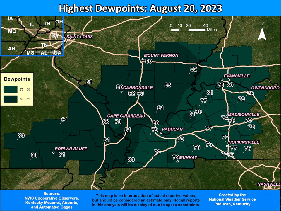 |
| Location | Provider | Aug 20 | Aug 21 | Aug 22 | Aug 23 | Aug 24 | Aug 25 | Aug 26 | Max |
| Cape Girardeau MO | ASOS | 83 | 82 | 82 | 82 | 83 | 82 | 81 | 83 |
| Carbondale IL | ASOS | 80 | 81 | 81 | 80 | 79 | 82 | 77 | 82 |
| Evansville IN | ASOS | 77 | 78 | 78 | 77 | 78 | 78 | M | 78 |
| Paducah KY | ASOS | 79 | 81 | 79 | 82 | 80 | 81 | 78 | 82 |
| Poplar Bluff MO | ASOS | 81 | 79 | 80 | 79 | 80 | 78 | 77 | 81 |
| Hopkinsville KY 2 E | AWOS | 77 | 77 | 81 | 82 | 81 | 82 | 77 | 82 |
| Sturgis KY 2 E | AWOS | 77 | 77 | 77 | 79 | 79 | 79 | 73 | 79 |
| Cairo IL | AWOS | 81 | 83 | M | M | 83 | 82 | 80 | 83 |
| Carmi IL | AWOS | 82 | 82 | 82 | 80 | 82 | 80 | 77 | 82 |
| Fort Campbell KY | AWOS | 79 | 82 | 84 | 81 | 84 | 84 | 80 | 84 |
| Greenville KY | AWOS | 76 | 79 | 78 | 78 | 79 | 79 | 74 | 79 |
| Harrisburg IL | AWOS | 83 | 84 | 83 | 82 | 82 | 83 | 79 | 84 |
| Henderson KY | AWOS | 78 | 79 | 79 | 79 | 79 | 79 | 74 | 79 |
| Madisonville KY | AWOS | 75 | 81 | 81 | 80 | 80 | 80 | 76 | 81 |
| Marion IL | AWOS | 82 | 84 | 84 | 82 | 82 | 83 | 77 | 84 |
| Metropolis IL | AWOS | 80 | 82 | 80 | 81 | 81 | 80 | 80 | 82 |
| Mt Vernon IL | AWOS | 80 | 81 | 80 | 80 | 80 | 81 | 74 | 81 |
| Murray KY | AWOS | 82 | 84 | 84 | 84 | 84 | 84 | 84 | 84 |
| Owensboro KY | AWOS | 76 | 78 | 78 | 78 | 80 | 81 | 75 | 81 |
| Perryville MO | AWOS | 85 | 86 | 85 | 84 | 85 | 83 | 78 | 86 |
| Sikeston MO | AWOS | 81 | 79 | 81 | 81 | 81 | 79 | 79 | 81 |
| La Center KY 5 NNE | KYMN | 81 | 81 | 82 | 80 | 81 | 83 | 81 | 83 |
| Benton KY 4 N | KYMN | 79 | 80 | 79 | 79 | 81 | 81 | 79 | 81 |
| Cadiz KY 4 SW | KYMN | 76 | 79 | 81 | 80 | 81 | 83 | 79 | 83 |
| Calhoun KY 5 NW | KYMN | 79 | 84 | 85 | 86 | 83 | 84 | 81 | 86 |
| Dixon KY 1 NW | KYMN | 80 | 81 | 81 | 81 | 82 | 81 | 77 | 82 |
| Elkton KY 5 SW | KYMN | 76 | 79 | 80 | 79 | 80 | 81 | 77 | 81 |
| Greenville KY 6 N | KYMN | 75 | 79 | 79 | 78 | 79 | 79 | 78 | 79 |
| Henderson KY 5 E | KYMN | 80 | 81 | 81 | 81 | 82 | 82 | 77 | 82 |
| Hickman KY 2 E | KYMN | 80 | 81 | 81 | 81 | 82 | 82 | 81 | 82 |
| Hopkinsville KY 6 N | KYMN | 76 | 82 | 81 | 81 | 81 | 84 | 80 | 84 |
| Madisonville KY 4 S | KYMN | 74 | 80 | 80 | 77 | 79 | 79 | 75 | 80 |
| Marion KY 4 NE | KYMN | 80 | 82 | 81 | 80 | 81 | 82 | 79 | 82 |
| Mayfield KY 6 SW | KYMN | 79 | 82 | 80 | 83 | 81 | 81 | 81 | 83 |
| Morganfield KY 4 E | KYMN | 81 | 82 | 83 | 83 | 82 | 82 | 79 | 83 |
| Murray KY 1 W | KYMN | 79 | 80 | 80 | 81 | 81 | 81 | 80 | 81 |
| Princeton KY 2 SE | KYMN | 77 | 81 | 80 | 80 | 80 | 81 | 78 | 81 |
| Bean Ridge IL | RAWS | 79 | 81 | 81 | 81 | 82 | 81 | 78 | 82 |
| Big Springs MO | RAWS | 80 | 82 | 78 | 81 | 78 | 78 | 77 | 82 |
| Crab Orchard IL | RAWS | 83 | 83 | 81 | 85 | 82 | 84 | 80 | 85 |
| Dixon Springs IL | RAWS | 81 | 81 | 80 | 81 | 81 | 82 | 77 | 82 |
| Doniphan MO | RAWS | 81 | 80 | 77 | 79 | 80 | 78 | 77 | 81 |
| Fort Campbell KY | RAWS | 75 | 82 | 81 | 81 | 81 | 82 | 78 | 82 |
| Golden Pond KY | RAWS | 76 | 81 | 79 | 82 | 81 | 82 | 78 | 82 |
| Greenville KY | RAWS | 75 | 80 | 75 | 79 | 79 | 79 | 75 | 80 |
| Piedmont MO 20 ENE | RAWS | 81 | 82 | 81 | 82 | 80 | 82 | 79 | 82 |
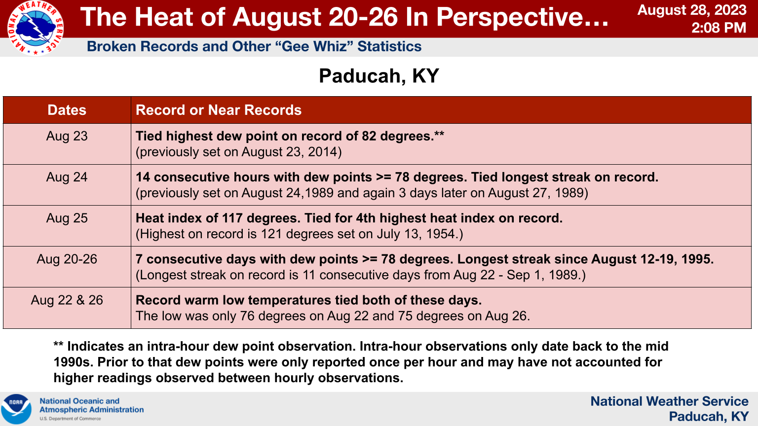
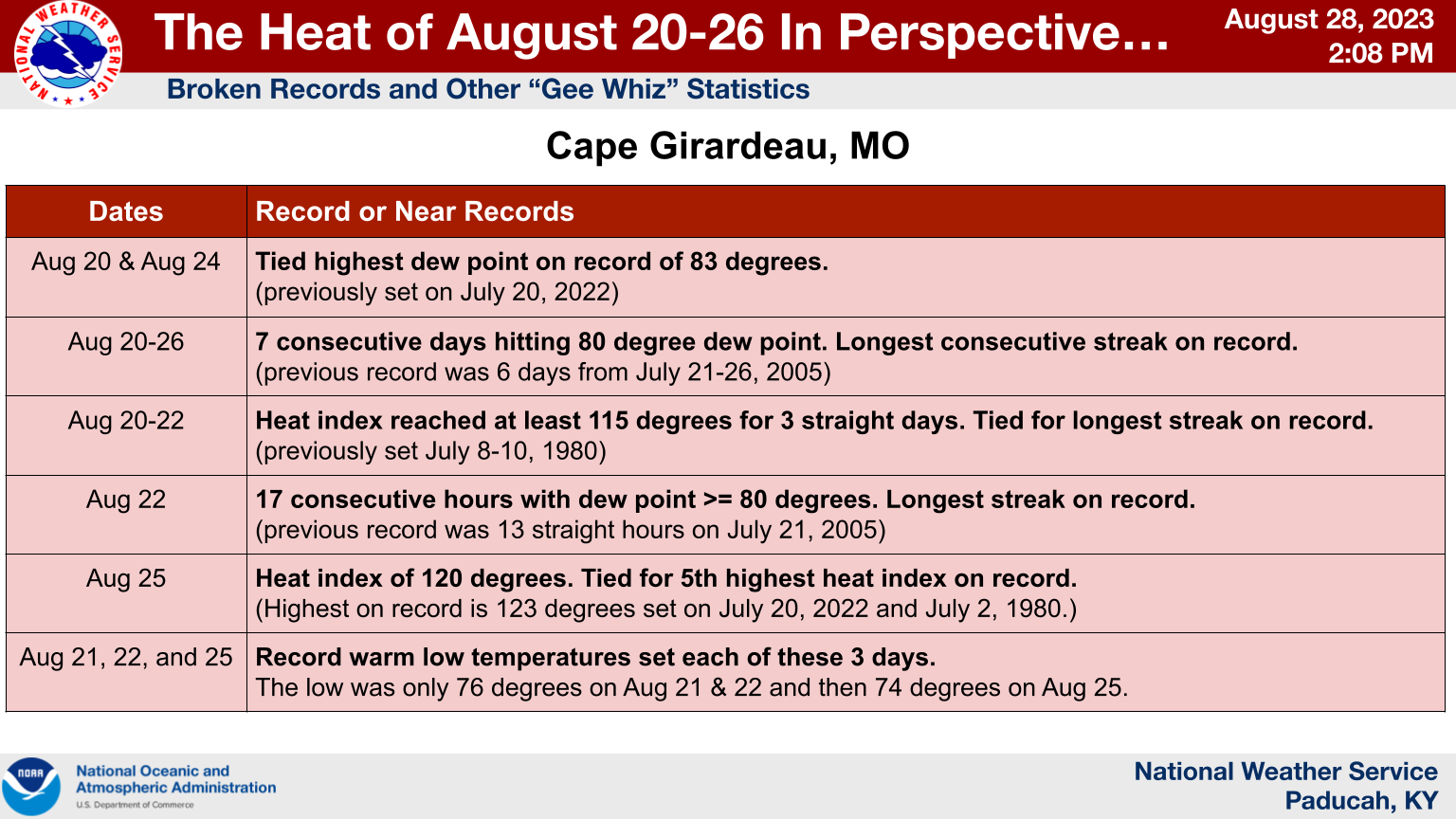
Records
A list of all of the records and other notable statistics that were observed in Paducah and Cape Girardeau. (Click on the images to enlarge)
 |
 |
Environment
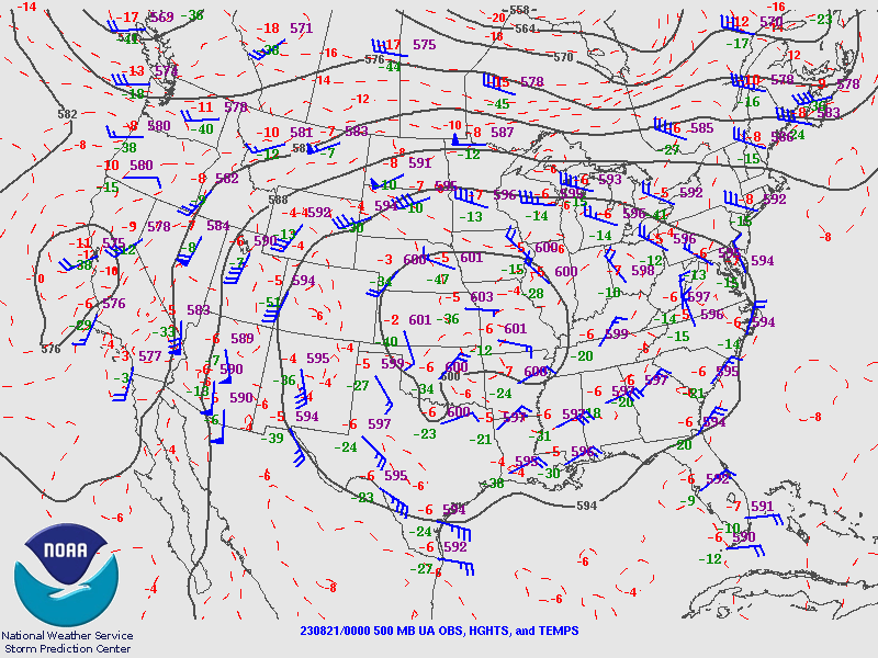
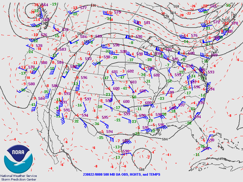
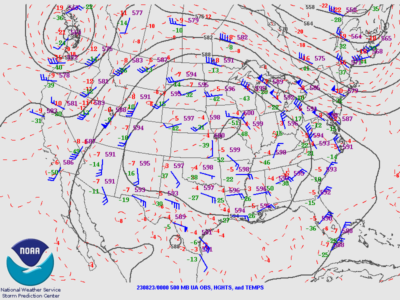
The upper level pattern at 500mb (roughly 18,000 feet above the surface) featured a large 600dam ridge that became established on August 20th across Missouri and Kansas. It reached its peak on August 21st before slowly shrinking through the 25th. Several upper air sites established their highest 500mb heights on record including Springfield, MO and Topeka, KS.
 |
 |
 |
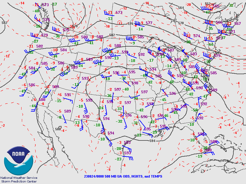 |
| August 20 - 7 PM CDT | August 21 - 7 PM CDT | August 22 - 7 PM CDT | August 23 - 7 PM CDT |
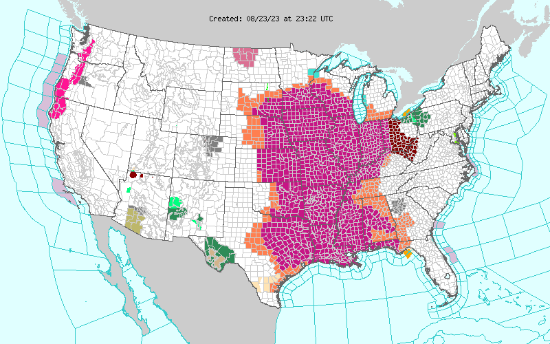 |
| Map showing all of the National Weather Service Watches, Warnings, and Advisories that were in effect the afternoon of Wednesday, August 23rd. The magenta color across much of the central part of the country shows where the Excessive Heat Warnings were in effect on this date. |
Additional Information
 |
Media use of NWS Web News Stories is encouraged! Please acknowledge the NWS as the source of any news information accessed from this site. |
|

