Overview
Another significant flooding event occurred across southeast Missouri into far southwest Kentucky on August 3rd and 4th. This was just 2 weeks after the historic flooding that occurred on July 19th. The hardest hit areas this time were approximately one county west of the July 19th event. Locations from Marble Hill and Sikeston, Missouri southeast to Hickman, Kentucky and Union City, Tennessee observed amounts of 6 to 12 inches. There were 2 waves of heavy rain, one occurring from around midnight into the morning on August 3rd and the second from around midnight into the morning on August 4th. The environment in place allowed very efficient rainfall production as thunderstorms trained over the same locations.Flooding
Numerous Flash Flood Warnings were issued during the overnight and morning hours on August 3rd and again on August 4th. A rare Flash Flood Emergency was issued around 6:30 AM for Fulton County Kentucky, including the city of Hickman. Numerous roads were closed due to high water over them, several evacuations of homes occurred, and there were a few water rescues.
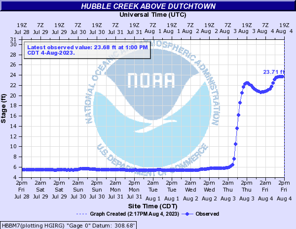
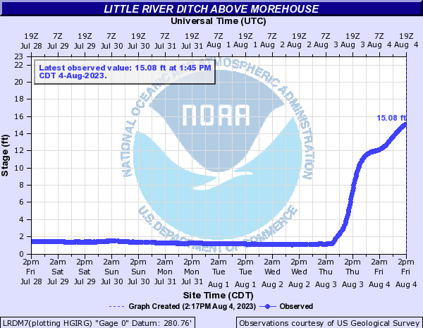
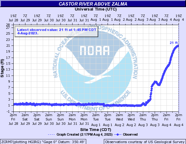
Several creeks and smaller rivers saw significant rises in a short time period due to the excessive rainfall amounts. Here are some of the more notable jumps along rivers in southeast Missouri and west Kentucky:
Hydrographs
 |
 |
 |
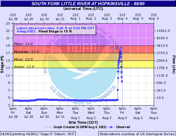 |
| Hubble Creek above Dutchtown, MO | Little River Ditch above Morehouse, MO | Castor River above Zalma, MO | South Fork Little River at Hopkinsville, KY 68/80 |
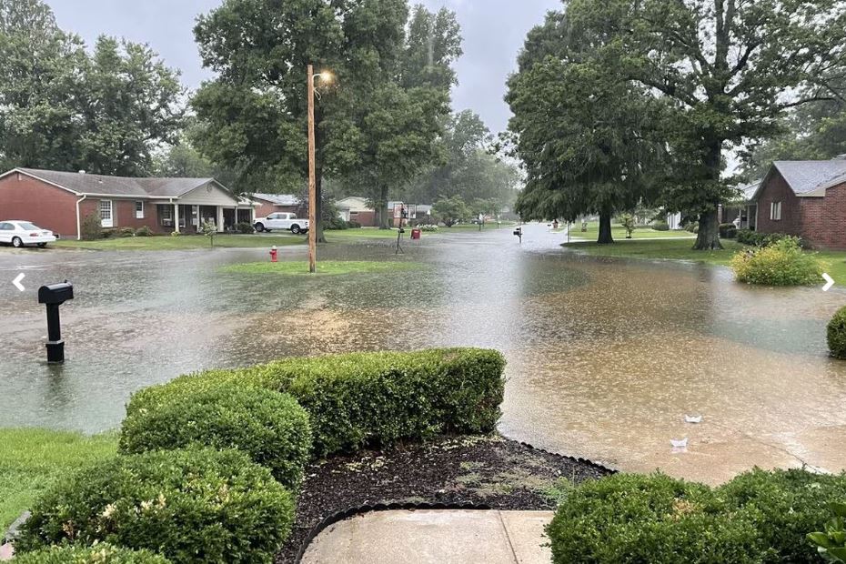
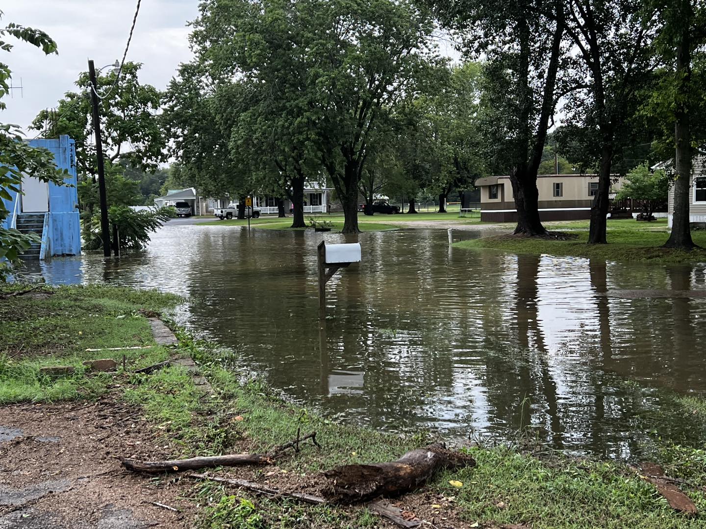
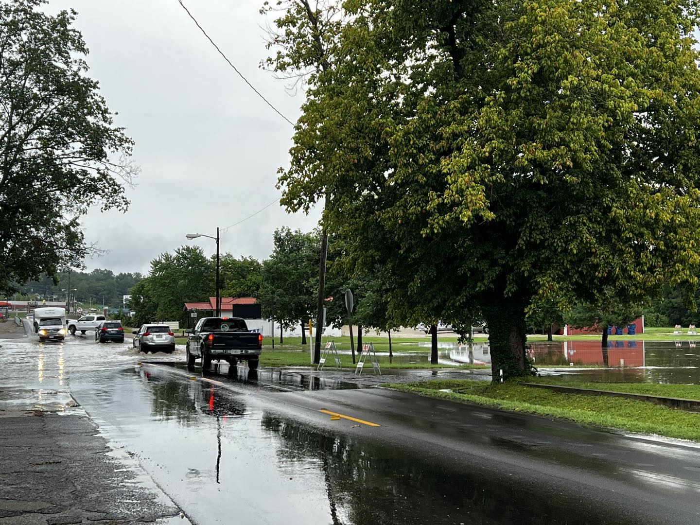
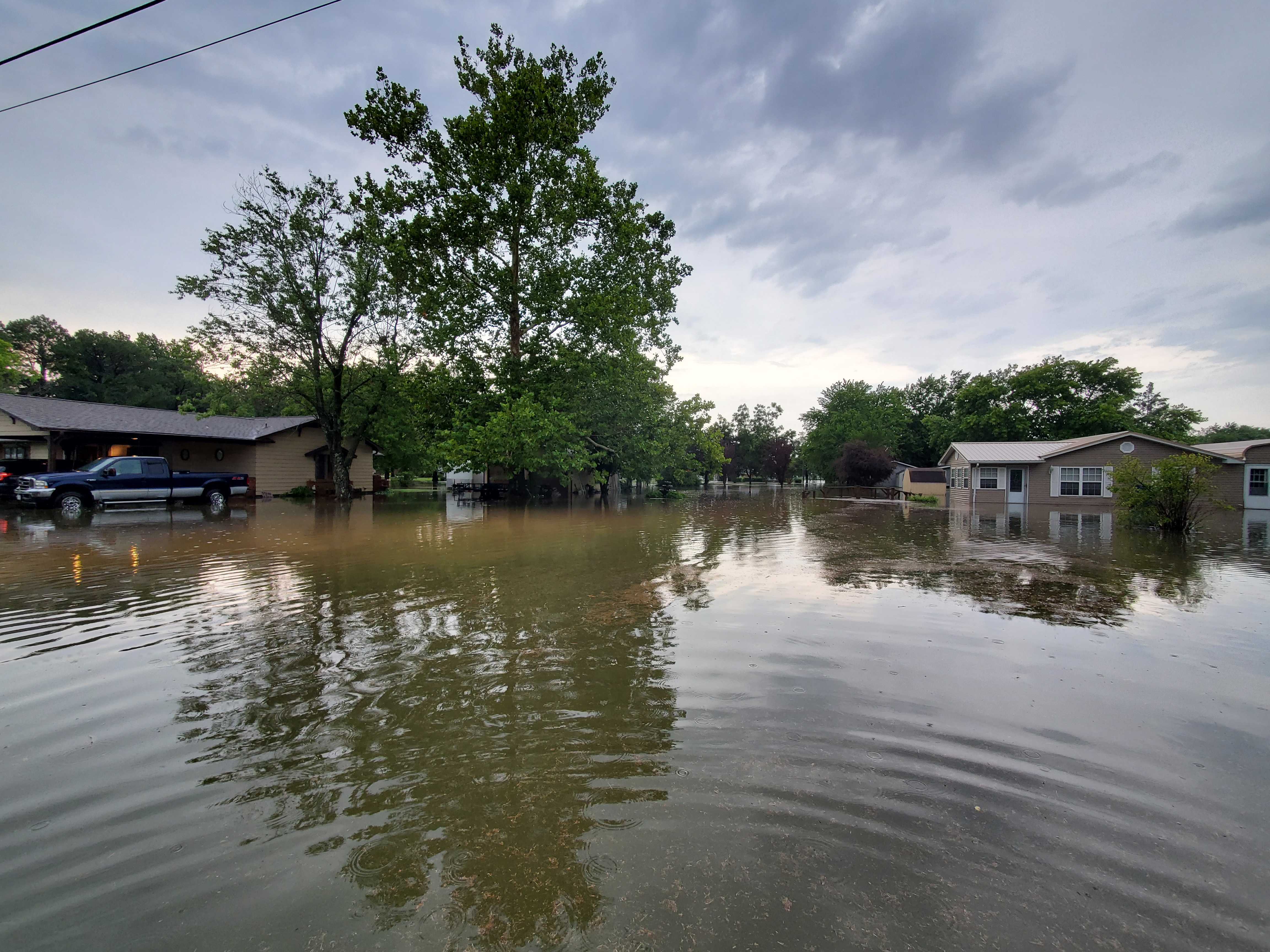
Photos
 |
 |
 |
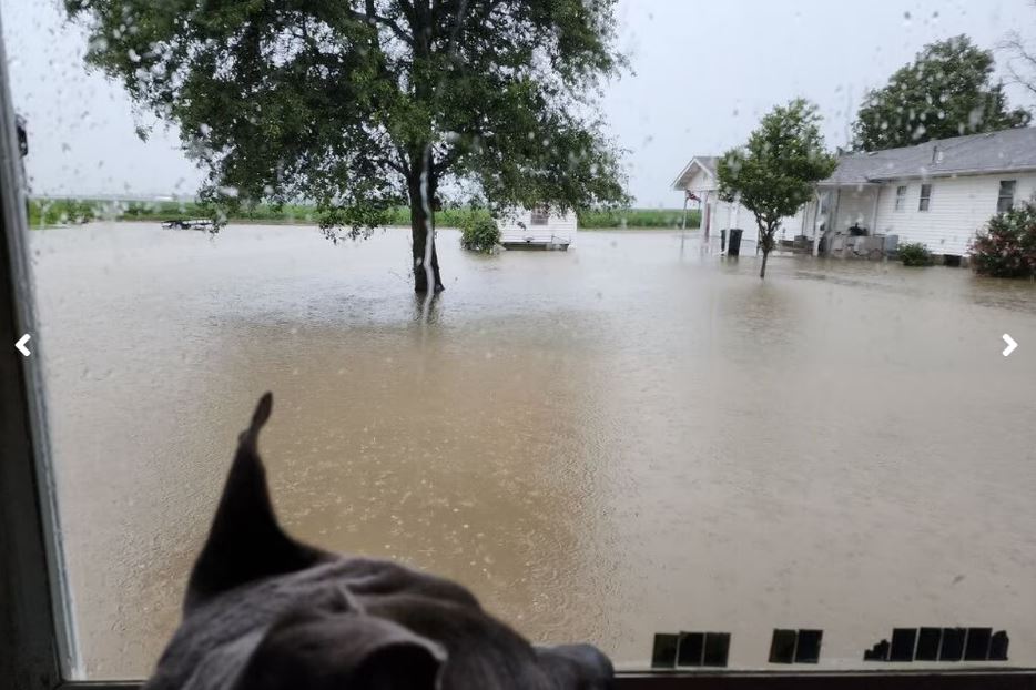 |
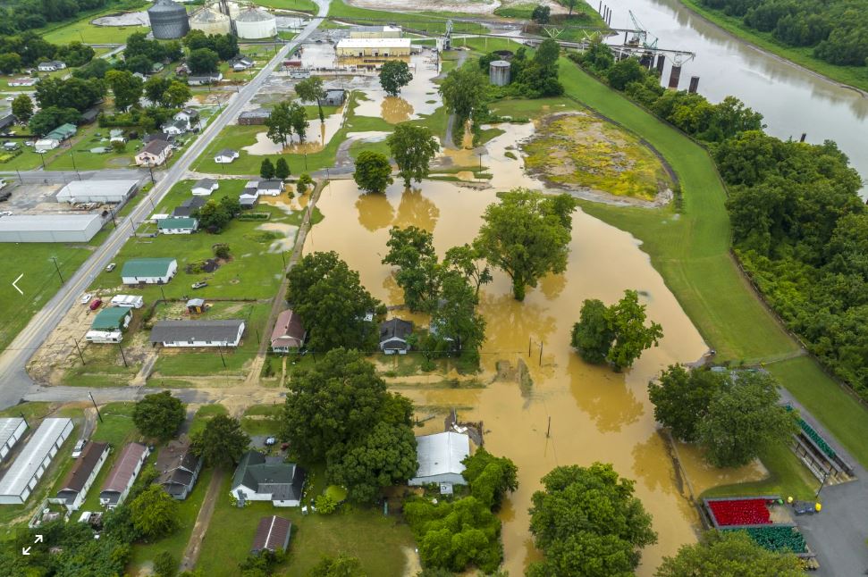
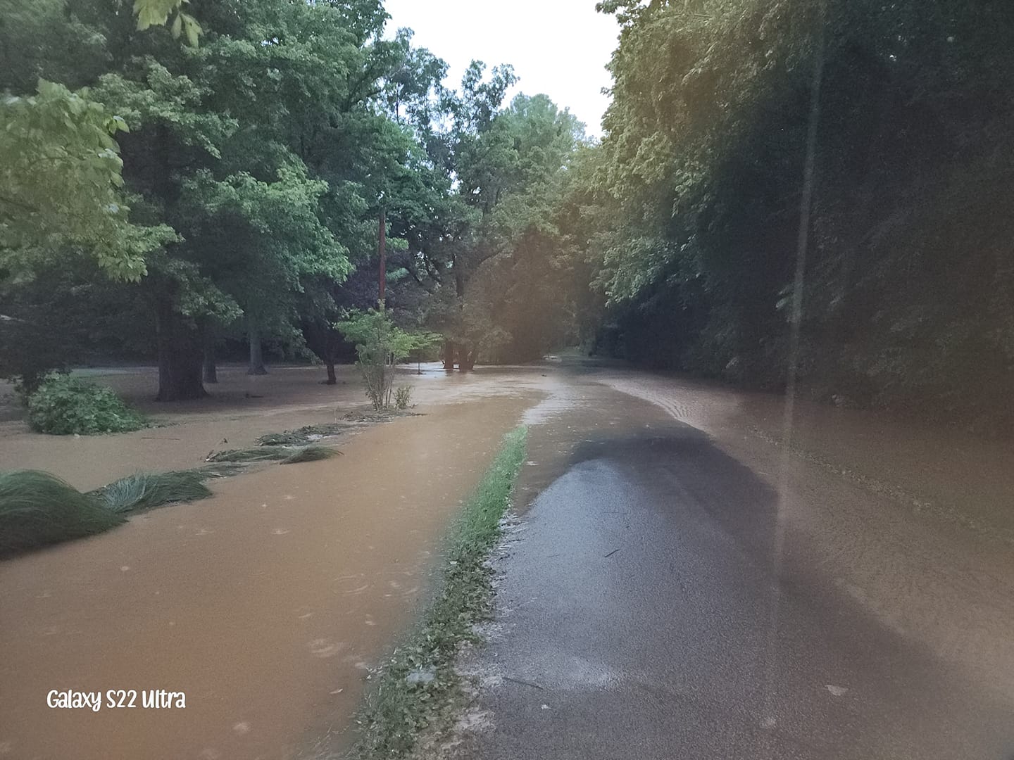
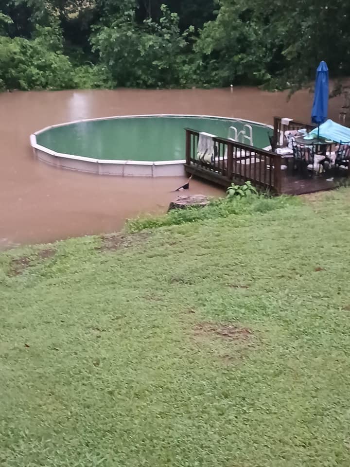
| Aerial footage of Hickman, KY courtesy of Ryan C. Hermens | Hickman, KY courtesy of Tori Watts | Backyard in Hickman, KY courtesy of KyleJona Kimmons | South of Sikeston, MO courtesy of Christina |
.JPG) |
 |
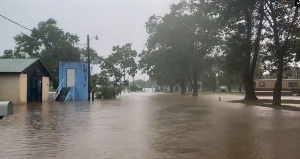 |
 |
| Loves Truck Stop in Sikeston, MO courtesy of Tracy Wilson | Sikeston, MO courtesy of KFVS-12 | Marble Hill, MO courtesy of Emily Pike | Marble Hill, MO courtesy of City of Marble Hill Facebook page |
 |
 |
| Marble Hill, MO courtesy of City of Marble Hill Facebook page | Advance, MO courtesy of Emily Pike |
Radar
Click here for a radar loop from the 1st wave of heavy rain from 10 PM August 2nd - 12 PM August 3rd.
Click here for a radar loop from the 2nd wave of heavy rain from 11 PM August 3rd - 2 PM August 4th.
Storm Reports
Preliminary Local Storm Report...Summary
National Weather Service Paducah KY
812 PM CDT Fri Aug 4 2023

..TIME...   ...EVENT...      ...CITY LOCATION...     ...LAT.LON...
..DATE...   ....MAG....      ..COUNTY LOCATION..ST.. ...SOURCE....
            ..REMARKS..

0926 AM     Rain             2 E Hickman             36.57N 89.15W
08/04/2023  M11.05 inch      Fulton             KY   Mesonet

            Measured over the past 48 hours.

0400 PM     Rain             1 NW Sikeston           36.89N 89.59W
08/04/2023  M10.94 inch      Scott              MO   Public

            2 day rainfall total at personal weather
            station in Sikeston.

0400 PM     Rain             2 SSW Miner             36.87N 89.55W
08/04/2023  M10.84 inch      Scott              MO   Public

            2 day rainfall total at personal weather
            station in Sikeston.

0400 PM     Rain             Benton                  37.10N 89.56W
08/04/2023  M9.01 inch       Scott              MO   Public

            2 day rainfall total at personal weather
            station in Benton.

0400 PM     Rain             Advance                 37.10N 89.91W
08/04/2023  M8.95 inch       Stoddard           MO   Public

            2 day rainfall total at personal weather
            station in Advance.

0400 PM     Rain             7 NNW Zalma             37.24N 90.12W
08/04/2023  M8.77 inch       Bollinger          MO   Public

            2 day rainfall total at personal weather
            station south of Grassy.

0700 AM     Rain             2 W Sikeston            36.88N 89.62W
08/04/2023  M8.48 inch       Scott              MO   CO-OP Observer

            2 day rainfall at Sikeston COOP station.
            Rain still ongoing at time of report.

0100 PM     Rain             Marble Hill             37.30N 89.98W
08/04/2023  M7.97 inch       Bollinger          MO   CO-OP Observer

            2 day rainfall total at COOP station in
            Marble Hill.

0400 PM     Rain             Chaffee                 37.18N 89.66W
08/04/2023  M7.81 inch       Scott              MO   Public

            2 day rainfall total at personal weather
            station just east of Chaffee.

0530 PM     Rain             4 SSW Gravelton         37.24N 90.27W
08/04/2023  M7.49 inch       Wayne              MO   Mesonet

            Corrects previous rain report from 4 SSW
            Gravelton. 2 day rainfall total for Piedmont
            RAWS site which is located in far northeast
            Wayne County along Hwy 34 between the towns
            of Clubb and Cascade.

0912 AM     Rain             New Hamburg             37.13N 89.59W
08/03/2023  E7.00 inch       Scott              MO   Public

            Rainfall total through 9 AM.

0456 PM     Rain             Benton                  37.10N 89.56W
08/03/2023  E6.29 inch       Scott              MO   Public

            Rainfall total since midnight at personal
            weather station.

0400 PM     Rain             2 ESE Sikeston          36.87N 89.55W
08/03/2023  M6.04 inch       Scott              MO   Public

            Rainfall total since midnight at Personal
            Weather Station.

0400 PM     Rain             Advance                 37.10N 89.91W
08/03/2023  M5.86 inch       Stoddard           MO   Public

            Rainfall total since midnight at personal
            weather station.

1100 AM     Rain             Marble Hill             37.30N 89.98W
08/03/2023  M5.83 inch       Bollinger          MO   CO-OP Observer

            12 hour rainfall total ending at 11AM at
            COOP station in Marble Hill. 36 hour
            rainfall total is 7.38 inches.

0600 AM     Rain             Albion                  38.37N 88.06W
08/03/2023  M5.71 inch       Edwards            IL   Trained Spotter

            Storm total rainfall.

0459 PM     Rain             6 NNW Zalma             37.23N 90.11W
08/03/2023  M5.24 inch       Bollinger          MO   Public

            Rainfall total since midnight at personal
            weather station 2 miles south of Grassy.

1003 AM     Flash Flood      Diehlstadt              36.96N 89.43W
08/03/2023                   Scott              MO   Trained Spotter

            Spotter reports street flooding continues in
            Diehlstadt, Scott County MO.

0440 PM     Rain             2 ENE Hickman           36.57N 89.16W
08/03/2023  M4.75 inch       Fulton             KY   Mesonet

            Kentucky Mesonet station HCKM Hickman KY 2
            E. Rainfall total since midnight.

0440 PM     Rain             2 NW Anniston           36.85N 89.36W
08/03/2023  M4.61 inch       Mississippi        MO   Mesonet

            Mesonet station MOA27 Charleston, MO South.
            24 hour rainfall total.

0500 PM     Rain             3 SE Burfordville       37.34N 89.77W
08/03/2023  M4.29 inch       Cape Girardeau     MO   Public

            Rainfall total since midnight at personal
            weather station.

0938 AM     Rain             East Prairie            36.78N 89.38W
08/03/2023  M3.00 inch       Mississippi        MO   Trained Spotter

            Trained spotter report of 3 inches of rain
            in East Prairie.

0411 PM     Rain             5 SE Evansville         37.93N 87.48W
08/03/2023  M1.60 inch       Vanderburgh        IN   Trained Spotter

            1.6 inches of rainfall measured since
            midnight on Angel Mounds, southeast side of
            Evansville.

0125 AM     Hail             Williamsville           36.97N 90.55W
08/03/2023  E0.75 inch       Wayne              MO   Emergency Mngr

            Penny size hail in Williamsville MO.

0937 AM     Flash Flood      Hickman                 36.56N 89.19W
08/04/2023                   Fulton             KY   Emergency Mngr

            Five homes in Hickman were evacuated earlier
            due to flash flooding in Hickman. Water
            levels are slowly receding, but numerous
            streets remained closed.

0912 AM     Landslide        Hickman                 36.56N 89.19W
08/04/2023                   Fulton             KY   Emergency Mngr

            Kentucky Highway 94 is closed in downtown
            Hickman due to a mudslide caused by heavy
            rain.

0900 AM     Flash Flood      1 WNW Oakton            36.67N 89.09W
08/04/2023                   Hickman            KY   Emergency Mngr

            Kentucky Highway 123 closed at Obion Creek
            between mile markers 14 to 16.

0753 AM     Flash Flood      1 SW Delta              37.19N 89.75W
08/04/2023                   Cape Girardeau     MO   Emergency Mngr

            Highway 25 is closed again due to flooding
            near Delta.

0740 AM     Flash Flood      1 NE New Madrid         36.60N 89.54W
08/04/2023                   New Madrid         MO   Emergency Mngr

            Water of portions of US Highway 61 near New
            Madrid. Approximate location.

0735 AM     Flash Flood      2 N Zalma               37.17N 90.09W
08/04/2023                   Bollinger          MO   Emergency Mngr

            Highway H north of Zalma is closed due.

0625 AM     Flash Flood      Hickman                 36.56N 89.19W
08/04/2023                   Fulton             KY   Emergency Mngr

            Widespread flash flooding occurring in
            Hickman. Numerous roads are closed. At least
            one home has been evacuated due to flooding.

0549 AM     Flash Flood      Hickman                 36.56N 89.19W
08/04/2023                   Fulton             KY   911 Call Center

            Several streets flooded in Hickman.

1032 AM     Flash Flood      Advance                 37.10N 89.91W
08/03/2023                   Stoddard           MO   Broadcast Media

            Streets flooded and homes with flooded
            basements on Benton Ave and Grissom St in
            Advance.

1030 AM     Flash Flood      Sikeston                36.88N 89.58W
08/03/2023                   Scott              MO   Public

            Public photo shared on Facebook of flooded
            streets and water threatening homes in
            Sikeston.

1004 AM     Flash Flood      1 NE Hickman            36.57N 89.18W
08/03/2023                   Fulton             KY   Emergency Mngr

            Fulton County emergency manager report of
            road flooding near senior center in Hickman,
            KY.

0849 AM     Flash Flood      1 SW Delta              37.19N 89.75W
08/03/2023                   Cape Girardeau     MO   Emergency Mngr

            Water over Highway 25 near the community of
            Arbor.

0836 AM     Flash Flood      3 NNW New Hamburg       37.16N 89.61W
08/03/2023                   Scott              MO   Emergency Mngr

            Flash flooding of County Highway 217 east of
            Chaffee.

0815 AM     Flash Flood      Marble Hill             37.30N 89.98W
08/03/2023                   Bollinger          MO   Emergency Mngr

            Marble Hill park has flooded.

0813 AM     Flash Flood      Marble Hill             37.30N 89.98W
08/03/2023                   Bollinger          MO   Broadcast Media

            Highway 34 is starting to flood near Roark
            Wood Products in Marble Hill.

0658 AM     Flash Flood      Patton                  37.50N 90.01W
08/03/2023                   Bollinger          MO   911 Call Center

            Several streets flooded in Patton.

0633 AM     Flood            2 ESE Owensville        38.26N 87.65W
08/03/2023                   Gibson             IN   Trained Spotter

            Water over State Route 168 between
            Owensville and Fort Branch at the 2, 3, and
            5 mile markers.

0400 AM     Flash Flood      Cisne                   38.51N 88.44W
08/03/2023                   Wayne              IL   Law Enforcement

            US 45 is closed due to flooding north of
            Cisne.

0228 AM     Flash Flood      1 N Albion              38.39N 88.06W
08/03/2023                   Edwards            IL   Law Enforcement

            Water was reported covering Route 130 about
            1 mile north of Albion at 228 AM. Semi
            driver relayed to dispatch that it felt like
            the water was trying to sweep the semi-truck
            off the road.

0204 AM     Flash Flood      Jeffersonville          38.45N 88.40W
08/03/2023                   Wayne              IL   Law Enforcement

            Water reported over a portion of US 45 north
            of Jeffersonville. Report relayed by
            Fairfield Police Department.

1155 PM     Tstm Wnd Dmg     Fruitland               37.45N 89.64W
08/02/2023                   Cape Girardeau     MO   Broadcast Media

            Trees down with power outages in Fruitland.
            Report relayed by KFVS 12. Time estimated
            from radar.

1132 PM     Tstm Wnd Dmg     Patton                  37.50N 90.01W
08/02/2023                   Bollinger          MO   Broadcast Media

            Power lines down near Patton. Relayed by
            KFVS 12. Time estimated from radar.

1120 PM     Tstm Wnd Dmg     4 WSW Silver Lake       37.66N 90.05W
08/02/2023                   Perry              MO   Broadcast Media

            Trees down with power outages at Lake Perry.
Rainfall
The primary axis of heaviest rain occurred across southeast Missouri into far southwest Kentucky. However, there were secondary narrow bands of heavy rain that occurred to the northeast across portions of southeast Illinois, southwest Indiana, and the southern Pennyrile region of west Kentucky. The corridor of 6 to 12 inches was focused from Bollinger County Missouri southeast into Fulton County Kentucky and northwest Tennessee. The 24 hour images show that the heaviest rain from the 2nd batch occurred roughly over the same area that experienced the heaviest from the 1st batch. The bullseye was displaced further southeast with the 2nd wave though, over Hickman and Union City, as opposed to over Marble Hill and into southern Cape Girardeau County with the initial wave.
The Fulton County Mesonet located 2 miles east of Hickman, KY observed 11.28" of rain in 33 hours from 3 AM August 3rd through 12 PM August 4th. This broke the previous 2 day rainfall record for Fulton County which was 9.80" back on January 1-2, 1966. The 1 day record also was shattered, with 9.69" occurring between 8 AM August 3rd and 8 AM August 4th. The previous 1 day record for the county was 7.24" set back on September 23, 2006.
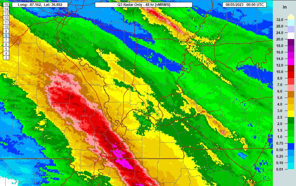 |
|
| 48 Hour MRMS rainfall estimates ending at 7 PM August 4th | |
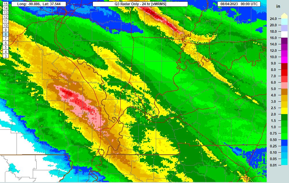 |
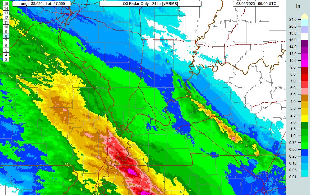 |
| 24 Hour MRMS rainfall estimates ending at 7 PM August 3rd | 24 Hour MRMS rainfall estimates ending at 7 PM August 4th |
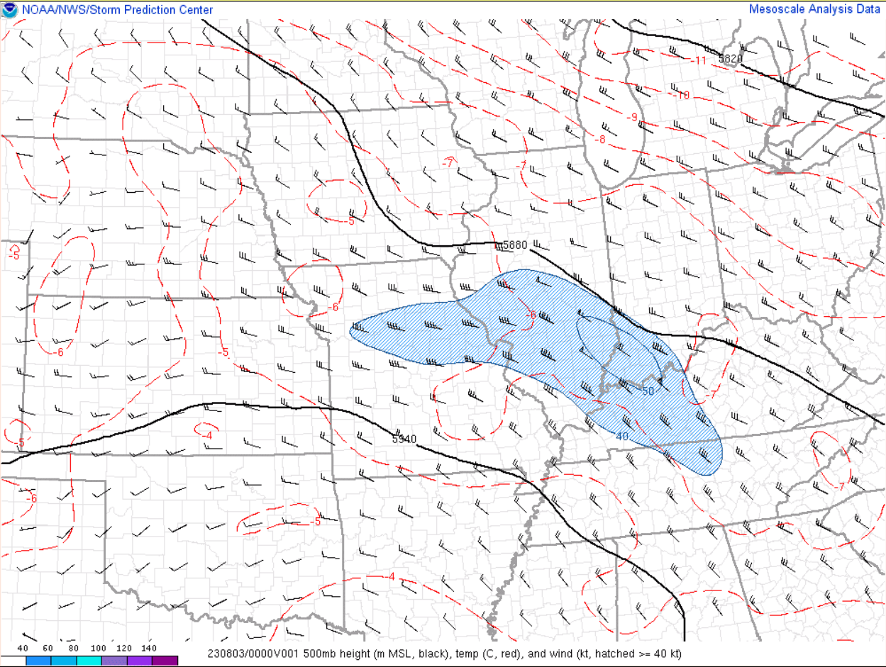
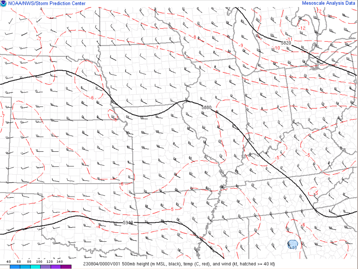
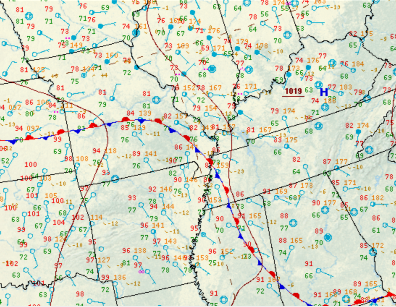
Environment
The synoptic pattern featured northwest flow at 500mb across the lower Ohio Valley. Meanwhile, surface analysis indicated a frontal boundary was drapped across southeast Missouri into west Tennessee.
 |
 |
 |
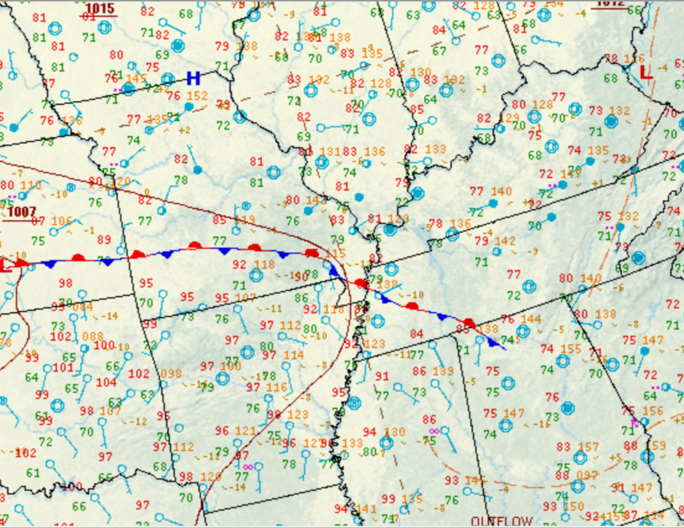 |
| 500mb chart at 7 PM August 3rd | 500mb chart at 7 PM August 4th | Surface chart at 7 PM August 3rd | Surface chart at 7 PM August 4th |
Southwest of the frontal boundary, extreme heat and humidity were present which led to high levels of instability. MUCAPE values of 2000-4000 j/kg were present across south central Missouri into northern Arkansas during the overnight on August 3rd. Even stronger instability was realized during the overnight on the 4th with values of 3000-5000 j/kg. The thunderstorms developed along the CAPE gradient which was positioned near and west of the Mississippi River. The mean steering flow was southeastward parallel to the boundary in place.
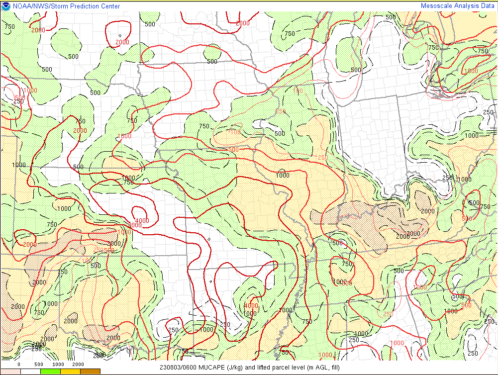 |
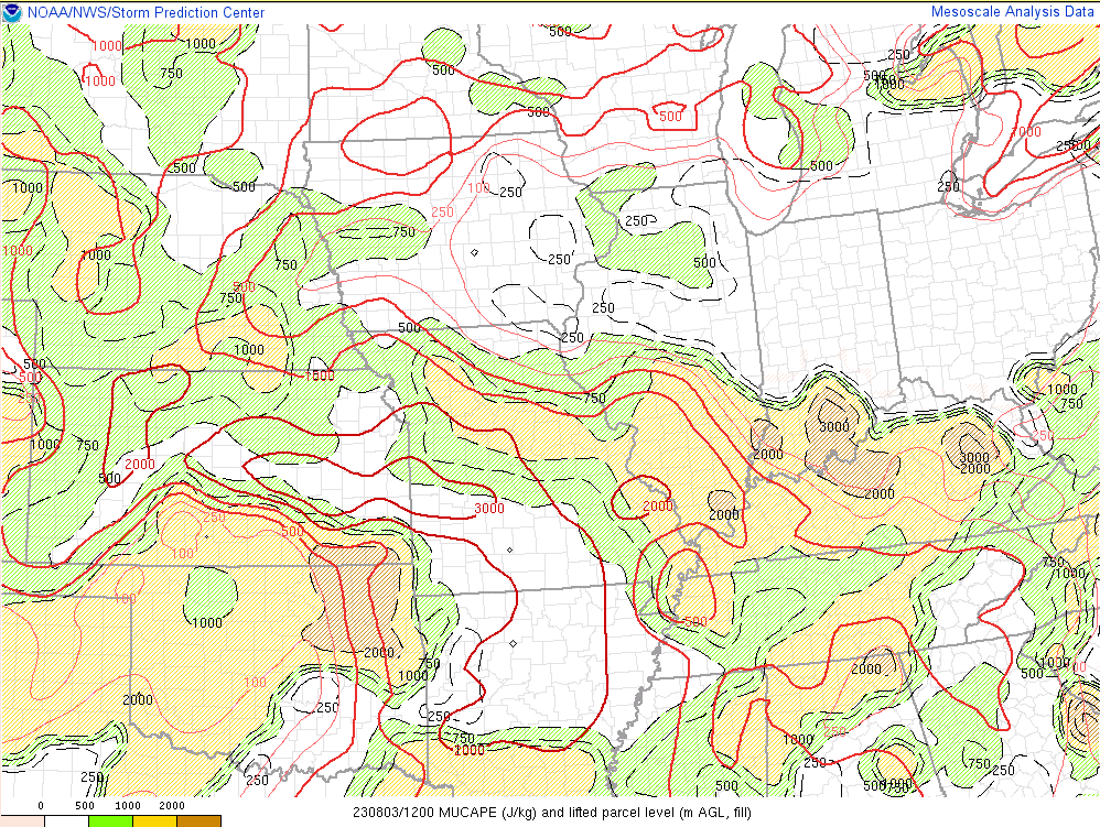 |
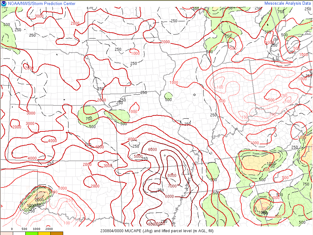 |
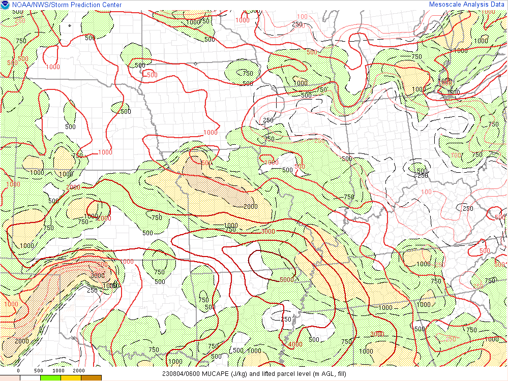 |
| MUCAPE at 1 AM August 3rd | MUCAPE at 7 AM August 3rd | MUCAPE at 7 PM August 3rd | MUCAPE at 1 AM August 4th |
Precipitable water values were extremely high, peaking around 2.3 to 2.4 inches each night/morning. Meanwhile, a healthy low level jet developed late night into the morning which helped provide the lift needed to allow the thunderstorms to back build and continuously move over the same locations.
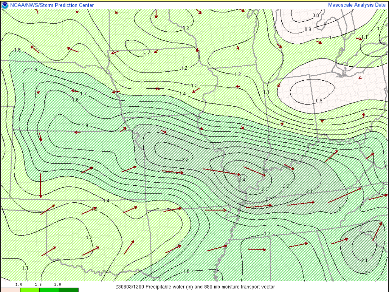 |
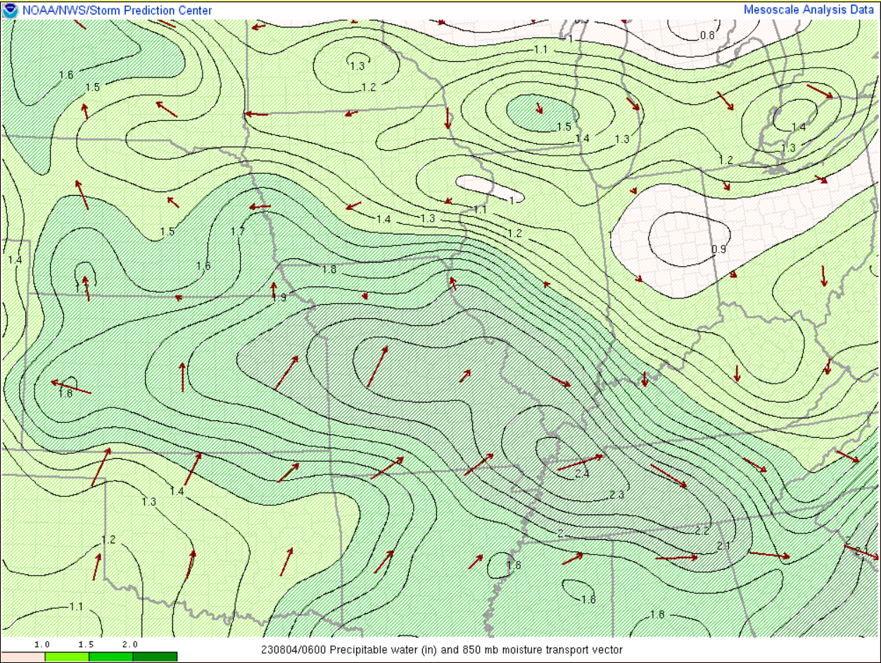 |
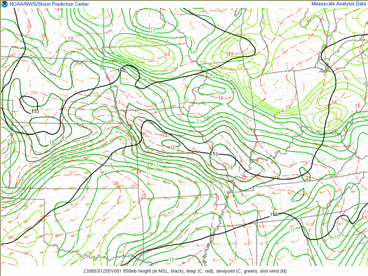 |
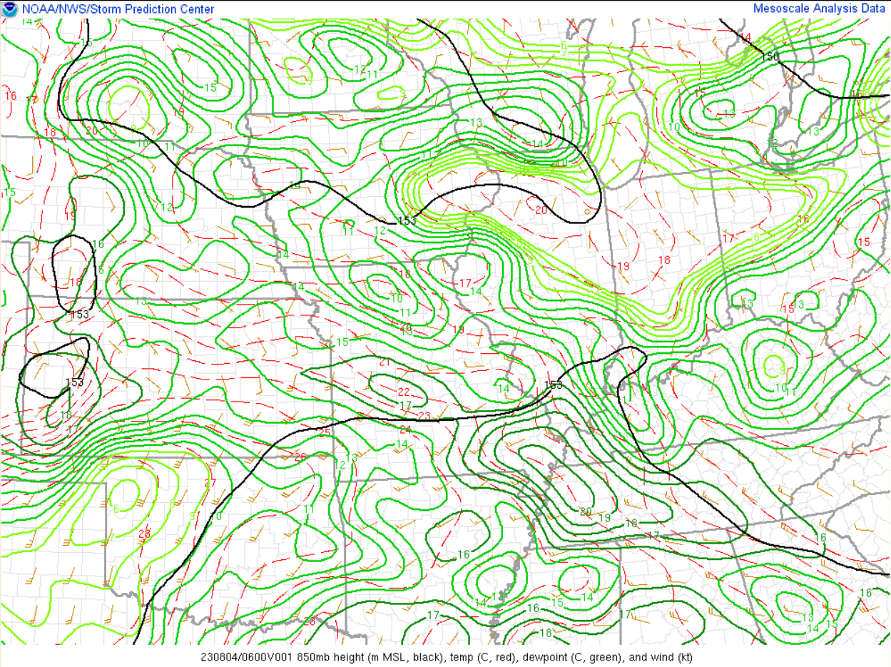 |
| Precipitable water at 7 AM August 3rd | Precipitable water at 1 AM August 4th | 850 mb chart at 7 AM August 3rd | 850 mb chart at 1 AM August 4th |
Additional Information
The Forecast - WFO Paducah started mentioning the pattern favored heavy rain/training thunderstorm potential in their AFD's a week beforehand. We issued a Flash Flood Watch shortly after 1 AM on August 2nd. The initial watch went through Noon on the 3rd but as the signal for a secondary heavy rain event grew, we extended the watch through Noon on the 4th.
As confidence grew that training thunderstorms would produce copious amounts of rainfall, WPC upgraded their excessive rainfall outlooks both on the evening of August 3rd and again on the 4th.
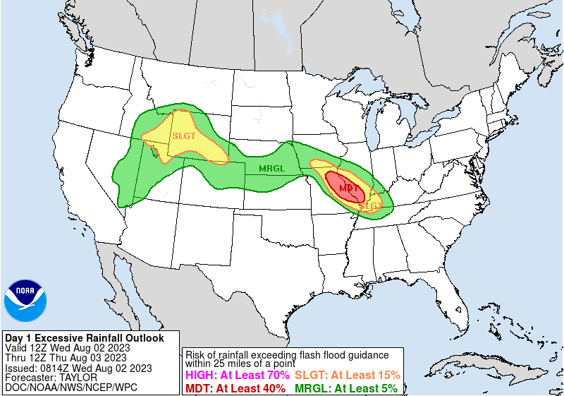 |
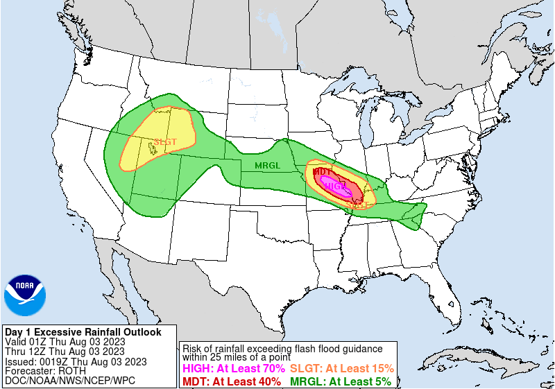 |
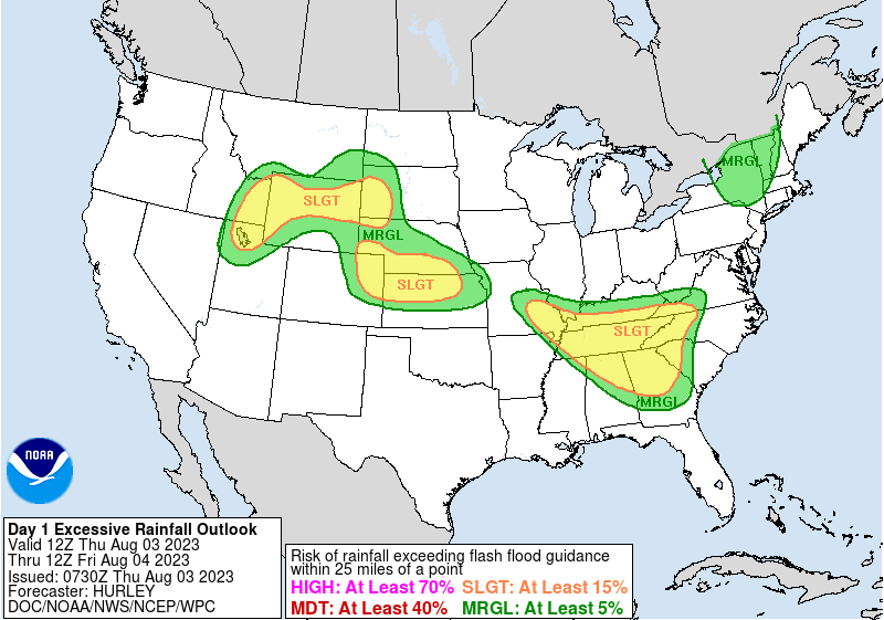 |
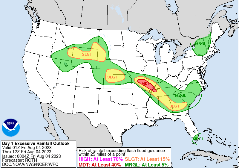 |
| Initial WPC Day 1 Outlook for Aug 3rd | WPC early evening update for Aug 3rd | Initial WPC Day 1 Outlook for Aug 4th | WPC early evening update for Aug 4th |
 |
Media use of NWS Web News Stories is encouraged! Please acknowledge the NWS as the source of any news information accessed from this site. |
|

