Overview
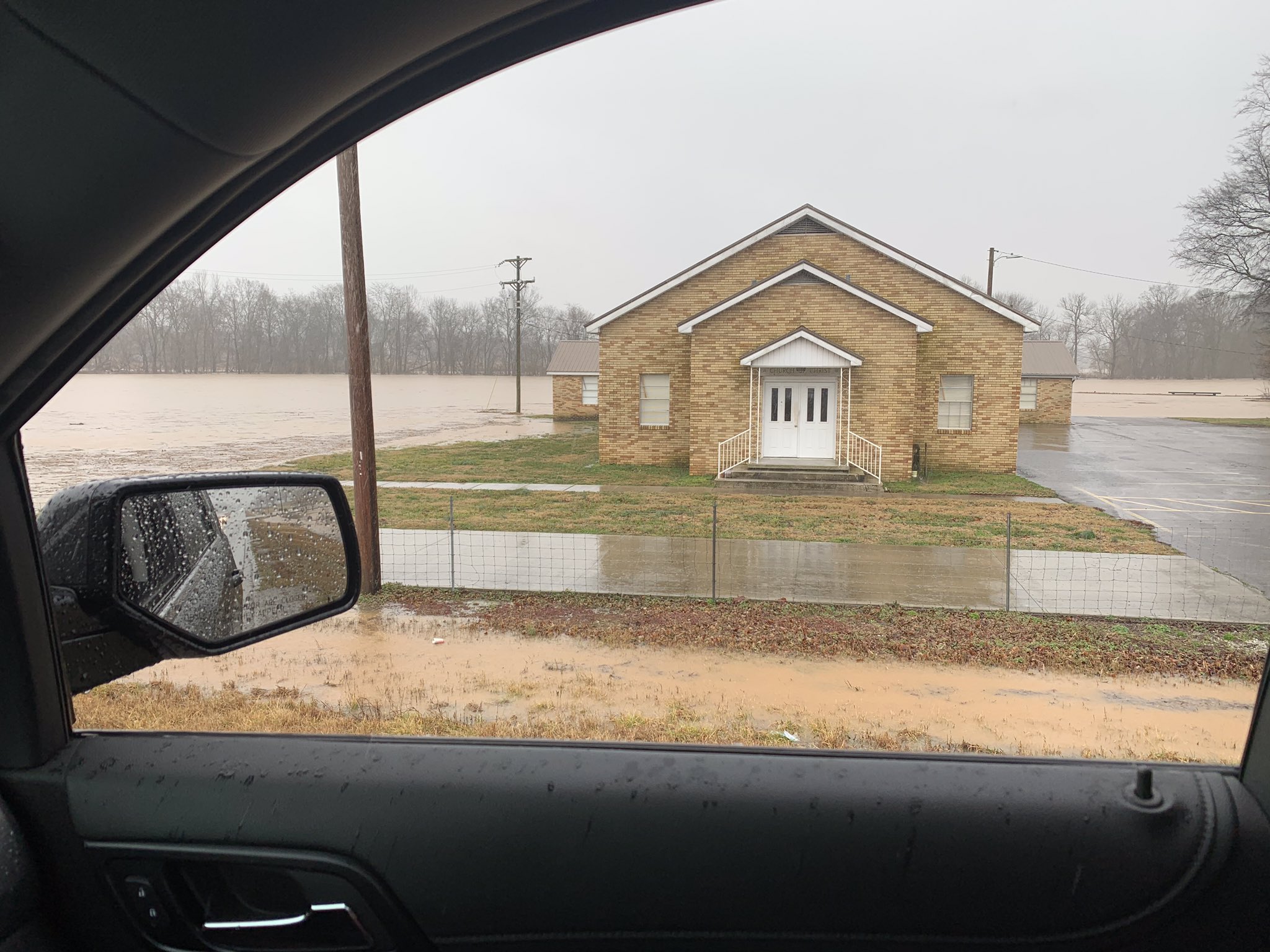
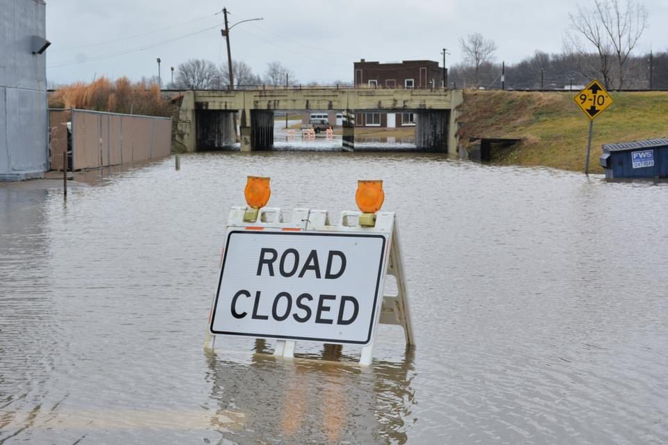
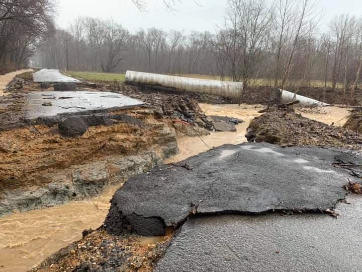
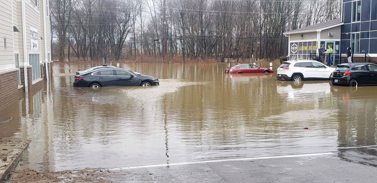
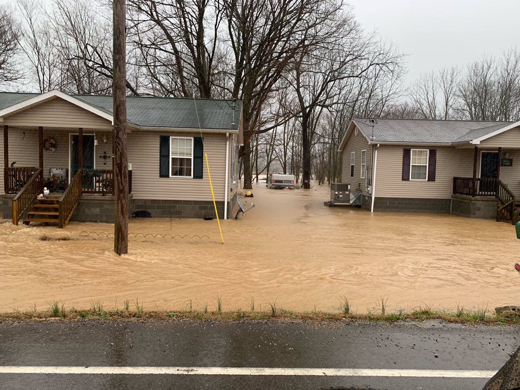
Rain moved northeastward across the region during the late afternoon and evening hours on February 27. Waves of moderate to heavy rain with embedded thunderstorms continued through the night and into the day on the 28th. The heaviest rain occurred across southern portions of western Kentucky during the morning and afternoon hours on the 28th. Hourly rainfall rates of 1 to 2 inches per hour caused major flash flooding to occur in the towns of Fulton, Murray, Hopkinsville, and Elkton along with surrounding areas. Storm total rainfall amounts were in the 4 to 7 inch range in this corridor. Numerous roads were impassable and/or washed out across these areas due to high water over them. Murray was hit especially hard during the morning on the 28th with several cars, homes, and businesses flooded. Flood waters were rising quickly in the town of Elkton shortly before 3 PM and at least 10 evacuations of homes were underway. NWS Paducah issued a rare Flash Flood Emergency for Todd County Kentucky at 2:50 PM. Highway 41 was impassable south of Hopkinsville during the late afternoon due to high water over all 4 lanes. The rain continued into the evening on the 28th, before gradually tapering off from northwest to southeast by around midnight.Flooding
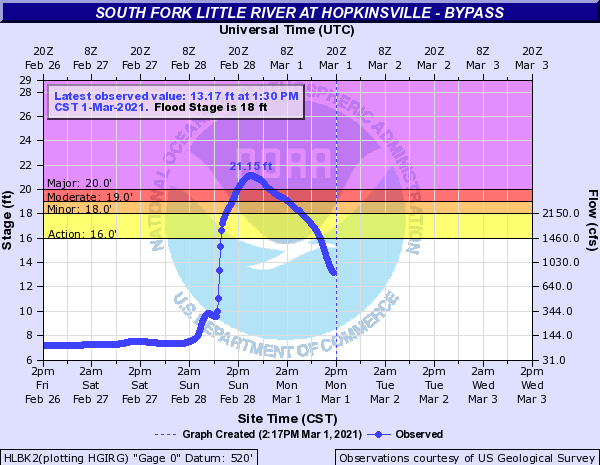
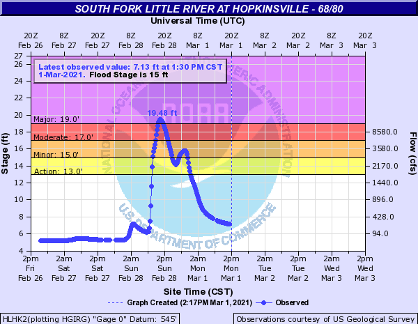
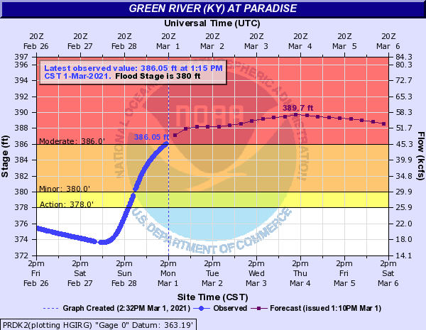
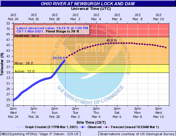
Water levels along smaller creeks and streams quickly rose during the day on Sunday. With 4 to 7 inches of rain in the Hopkinsville area, the South Fork Little River gauges experienced major flooding. In fact, the Bypass gauge recorded a crest of 21.15 feet which was only 2 tenths below the record of 21.35 feet set on July 7, 2016. Records date back to 2010 for this gauge. River levels continued to rise along other area rivers over the first week of March. On March 1, there were a total of 16 points with River Flood Warnings issued across the Paducah forecast area. This included points along the Green, Ohio, Little Wabash, Wabash, Patoka, White, and South Fork Little Rivers.
Hydrographs (Click images to enlarge)
 |
 |
 |
 |
| South Fork Little River - Hopkinsville Bypass Gauge | South Fork Little River - Hopkinsville 68/80 Gauge | Green River at Paradise, KY | Ohio River at Newburgh, IN |
Photos (Click images to enlarge)
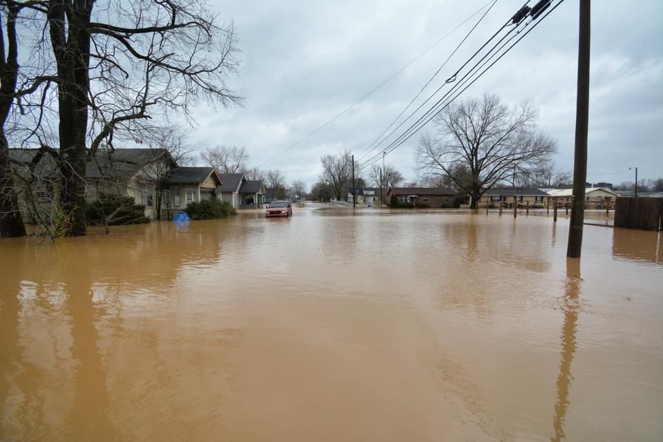
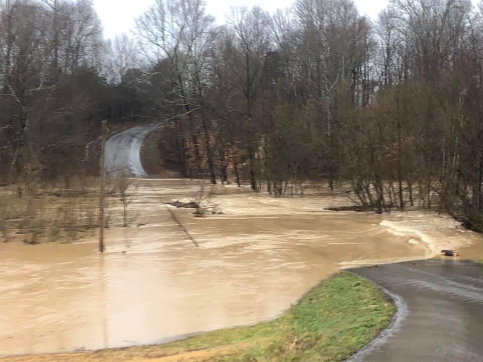
Here are various pictures we received from the significant flooding across southern portions of western Kentucky including Murray, Hopkinsville, Fulton, and Elkton.
 |
 |
 |
%20via%20WHOP%20AM%20FM.jpg) |
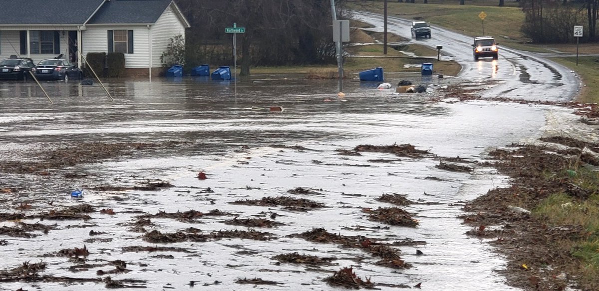
| Hopkinsville, KY via Joshua Claussen | Little River out of its banks along Hwy 68 East of Hopkinsville via CCEM | Corner of Northwood Dr. and 4th Street in Murray, KY via Stephanie Anderson | Flooding in Elkton via WHOP AM/FM |
 |
 |
 |
 |
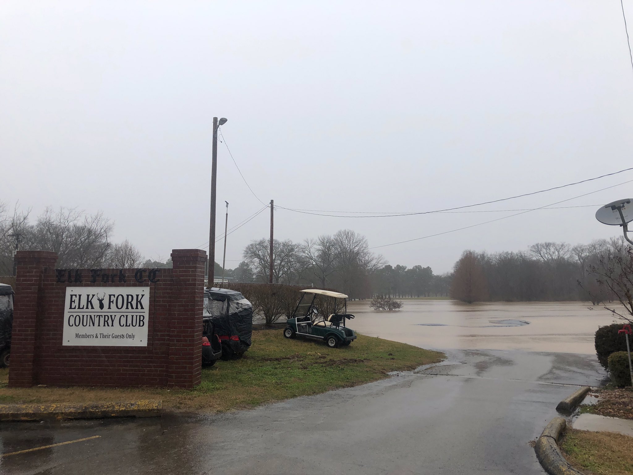
| Fulton, KY via Joni Yates | Flooding near Elk Fork Country Club in Elkton via Marla Gillespie | Fulton, KY via Joni Yates | Wingo, KY via Beau Dodson |
 |
 |
 |
 |
| Pea Ridge Road and Stokes Chapel Road in Todd County via WHOP AM/FM | Murray, KY via Beau Dodson | Murray, KY behind The Keg and 16th Street via Stephanie Anderson | Flooding in Elkton via WHOP AM/FM |
Rain Reports
Many locations across the region received 1.5" to 4" of rain for the 48 hour period ending at 8 AM March 1st. However, a swath of heavier amounts was focused across southern portions of western Kentucky from Fulton to Murray, Hopkinsville, and Elkton. This area received 4 to 7 inches for the event. The Mesonet station in Murray picked up a little over 1.5" within an hour from 8 to 9 AM on February 28. Hourly rainfall rates of 1 to 2 inches per hour were observed for a period of time during the morning and afternoon. Heavy rainfall of 2 to 3.5" occurred in the Evansville metro area. The Evansville airport picked up 2.22" on February 28, which set a new daily record. Below the rainfall map you will find a listing of rainfall reports for the 48 hour period ending at 8 AM March 1 along with Local Storm Reports issued during the event.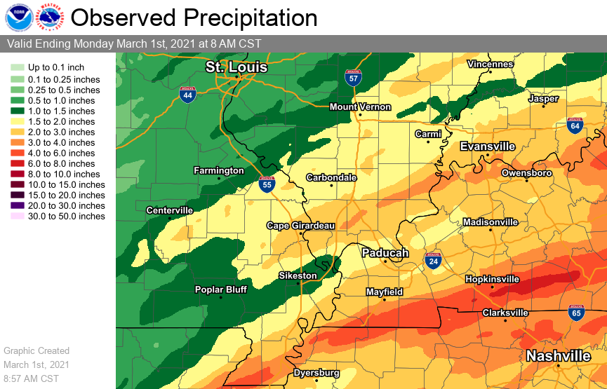 |
| 48 hour rainfall totals ending at 8 AM March 1, 2021 |
PUBLIC INFORMATION STATEMENT
NATIONAL WEATHER SERVICE PADUCAH KY
852 AM CST MON MAR 1 2021

...PRECIPITATION REPORTS...

LOCATION                     AMOUNT    TIME/DATE       PROVIDER
1.9 S ELKTON KY              6.60 IN   0700 AM 03/01   HADS
FARMINGTON KY 5.6 S          6.48 IN   0700 AM 03/01   COCORAHS
MURRAY KY                    5.64 IN   0700 AM 03/01   COOP
MURRAY KY 1 WSW              5.63 IN   0700 AM 03/01   COCORAHS
ELKTON KY                    5.52 IN   0831 AM 03/01   CWOP
3 SE ALLEGRE KY              5.49 IN   0830 AM 03/01   AWS
MURRAY 1 W KY                5.44 IN   0830 AM 03/01   KYMN2
1.2 SE HOPKINSVILLE KY       5.27 IN   0700 AM 03/01   HADS
5 SSE AURORA KY              5.14 IN   0830 AM 03/01   AWS
7.7 SW GRACEY KY             5.13 IN   0700 AM 03/01   HADS
FULTON KY 5 W                5.08 IN   0700 AM 03/01   COCORAHS
FULTON KY 3.3 NE             4.56 IN   0700 AM 03/01   COCORAHS
HOPKINSVILLE KY 0.3 NW       4.53 IN   0700 AM 03/01   COCORAHS
HERNDON KY 4 SW              4.48 IN   0700 AM 03/01   COOP
ELKTON KY 5 SW               4.46 IN   0830 AM 03/01   KYMN2
KENLAKE RESORT KY            4.30 IN   0600 AM 03/01   COOP
OAK GROVE KY 4.6 NW          4.29 IN   0700 AM 03/01   COCORAHS
FORT CAMPBELL KY             4.24 IN   0756 AM 03/01   AWOS
MURRAY KY                    4.18 IN   0831 AM 03/01   CWOP
4 ESE HERNDON KY             3.98 IN   0830 AM 03/01   AWS
MAYFIELD KY                  3.93 IN   0832 AM 03/01   CWOP
GOLDEN POND KY               3.89 IN   0821 AM 03/01   RAWS
NEWBURGH IN 0.3 SE           3.60 IN   0700 AM 03/01   COCORAHS
HENDERSON KY 0.4 SSW         3.58 IN   0700 AM 03/01   COCORAHS
HERNDON KY                   3.45 IN   0830 AM 03/01   CWOP
CADIZ KY 4 SW                3.44 IN   0600 AM 03/01   COOP
1.8 NE HOPKINSVILLE KY       3.40 IN   0730 AM 03/01   HADS
3.3 NW UNIONTOWN KY          3.40 IN   0600 AM 03/01   COOP
PRINCETON KY                 3.34 IN   0831 AM 03/01   CWOP
HENDERSON 5 E KY             3.33 IN   0830 AM 03/01   KYMN2
CADIZ KY 2 NNW               3.31 IN   0600 AM 03/01   COOP
HOPKINSVILLE 6 N KY          3.24 IN   0830 AM 03/01   KYMN2
CADIZ 4 SW KY                3.21 IN   0830 AM 03/01   KYMN2
CANTON KY                    3.19 IN   0700 AM 03/01   HADS
EVANSVILLE IN 8.8 WSW        3.16 IN   0810 AM 03/01   COCORAHS
BOONVILLE IN 4.5 WSW         3.14 IN   0700 AM 03/01   COCORAHS
ROCKPORT IN 4.0 WNW          3.10 IN   0700 AM 03/01   COCORAHS
NEWBURGH IN 2.2 NW           3.09 IN   0700 AM 03/01   COCORAHS
NEW CONCORD KY               3.02 IN   0831 AM 03/01   CWOP
FULTON KY 5.0 W              2.95 IN   0600 AM 03/01   COCORAHS
TRENTON KY 2 SW              2.95 IN   0700 AM 03/01   COCORAHS
6 S JUNCTION IN              2.94 IN   0835 AM 03/01   AWS
HENDERSON 8 SSW              2.93 IN   0700 AM 03/01   COOP
NEWBURGH IN 1.8 ENE          2.89 IN   0948 PM 02/28   COCORAHS
NEWBURGH IN                  2.87 IN   0831 AM 03/01   CWOP
FARMINGTON KY 5.6 S          2.86 IN   0700 AM 03/01   COCORAHS
OWENSBORO KY 4.9 S           2.85 IN   0700 AM 03/01   COCORAHS
EVANSVILLE IN                2.78 IN   0831 AM 03/01   CWOP
MAYFIELD KY 6 SW             2.77 IN   0830 AM 03/01   KYMN2
2.7 W UNIONTOWN KY           2.76 IN   0800 AM 03/01   HADS
MT. VERNON IN                2.73 IN   0831 AM 03/01   CWOP
OAKLAND CITY IN              2.71 IN   0831 AM 03/01   CWOP
MADISONVILLE KY              2.65 IN   0832 AM 03/01   CWOP
MOUNT VERNON IN 10.6 ENE     2.65 IN   0700 AM 03/01   COCORAHS
EVANSVILLE IN 6.7 NW         2.63 IN   0700 AM 03/01   COCORAHS
MARION KY 6.3 NW             2.58 IN   0700 AM 03/01   COCORAHS
EDDYVILLE KY 2 NNE           2.57 IN   0804 AM 03/01   COCORAHS
COBDEN IL 0.8 SSE            2.56 IN   0700 AM 03/01   COCORAHS
CENTRAL CITY KY              2.55 IN   0832 AM 03/01   CWOP
0.7 NW HENDERSON KY          2.54 IN   0745 AM 03/01   HADS
SMITHLAND LOCK AND DAM       2.53 IN   0600 AM 03/01   COOP
COBDEN IL 4 ENE              2.52 IN   0700 AM 03/01   COCORAHS
5.2 N PEMBROKE KY            2.50 IN   0730 AM 03/01   HADS
MOUNT VERNON IN 11.0 ENE     2.50 IN   0700 AM 03/01   COCORAHS
FRANCISCO IN 0.1 SE          2.49 IN   0700 AM 03/01   COCORAHS
4.3 W CERULEAN KY            2.47 IN   0700 AM 03/01   HADS
HICKMAN KY 2 E               2.47 IN   0830 AM 03/01   KYMN2
2.0 W EVANSVILLE IN          2.43 IN   0800 AM 03/01   COOP
BEAN RIDGE IL                2.41 IN   0757 AM 03/01   RAWS
DIXON SPRINGS IL             2.34 IN   0808 AM 03/01   RAWS
CROFTON KY 3 N               2.33 IN   0700 AM 03/01   COOP
EVANSVILLE IN 5.9 WNW        2.33 IN   0700 AM 03/01   COCORAHS
OWENSBORO KY                 2.33 IN   0756 AM 03/01   AWOS
CAPE GIRARDEAU MO 2 N        2.33 IN   0724 AM 03/01   COCORAHS
ROSICLARE IL 5 NW            2.33 IN   0700 AM 03/01   COOP
EVANSVILLE IN 5.4 NNE        2.32 IN   0700 AM 03/01   COCORAHS
HENDERSON KY                 2.29 IN   0756 AM 03/01   AWOS
EVANSVILLE IN 10 NW          2.28 IN   0700 AM 03/01   COCORAHS
EVANSVILLE IN                2.27 IN   0835 AM 03/01   AWS
SCOTT CITY MO 0.9 E          2.27 IN   0700 AM 03/01   COCORAHS
MADISONVILLE KY 4 S          2.23 IN   0830 AM 03/01   KYMN2
EVANSVILLE IN                2.22 IN   0835 AM 03/01   AWS
CARBONDALE IL 2.8 S          2.22 IN   0630 AM 03/01   COCORAHS
3.0 W FAIRDEALING MO         2.21 IN   0700 AM 03/01   HADS
GREENVILLE KY 6 N            2.21 IN   0830 AM 03/01   KYMN2
DONGOLA IL                   2.20 IN   0835 AM 03/01   AWS
CALHOUN KY 5 NW              2.19 IN   0830 AM 03/01   KYMN2
SCHELLER IL                  2.16 IN   0832 AM 03/01   CWOP
W.FRANKFORT IL               2.15 IN   0830 AM 03/01   CWOP
MOUNT VERNON IN              2.12 IN   0821 AM 03/01   CWOP
EVANSVILLE IN                2.11 IN   0754 AM 03/01   ASOS
CHRISTOPHER IL 1.1 NNW       2.10 IN   0700 AM 03/01   COCORAHS
CADIZ KY 2 NNW               2.09 IN   0545 AM 03/01   COCORAHS
PADUCAH KY 1.3 W             2.08 IN   0700 AM 03/01   COCORAHS
LIVERMORE KY                 2.08 IN   0800 AM 03/01   HADS
CAPE GIRARDEAU MO            2.06 IN   0753 AM 03/01   ASOS
3.4 W WARE IL                2.04 IN   0830 AM 03/01   HADS
2 W EVANSVILLE IN            2.04 IN   0834 AM 03/01   AWS
GREENVILLE KY                2.03 IN   0755 AM 03/01   RAWS
1.5 S DUTCHTOWN MO           2.03 IN   0700 AM 03/01   HADS
POSEYVILLE IN 2.8 NW         2.03 IN   0700 AM 03/01   COCORAHS
POSEYVILLE IN 2.9 SSE        2.03 IN   0700 AM 03/01   COCORAHS
MOUNT VERNON IN              2.01 IN   0834 AM 03/01   AWS
PRINCETON KY 2 SE            2.01 IN   0830 AM 03/01   KYMN2
BROOKPORT IL 7 ENE           2.00 IN   0700 AM 03/01   COCORAHS
MARION KY 4 NE               2.00 IN   0830 AM 03/01   KYMN2
3.0 NE FARRAR MO             2.00 IN   0830 AM 03/01   HADS
PRELIMINARY LOCAL STORM REPORT...SUMMARY
NATIONAL WEATHER SERVICE PADUCAH KY
235 PM CST MON MAR 1 2021
..TIME... ...EVENT... ...CITY LOCATION... ...LAT.LON...
..DATE... ....MAG.... ..COUNTY LOCATION..ST.. ...SOURCE....
..REMARKS..
0845 AM HEAVY RAIN 4 N BELL CITY 36.59N 88.51W
02/28/2021 M3.80 INCH GRAVES KY COCORAHS
COCORAHS STATION KY-GV-4 FARMINGTON 5.6 S.
0900 AM FLASH FLOOD MURRAY 36.61N 88.30W
02/28/2021 CALLOWAY KY TRAINED SPOTTER
CONSIDERABLE FLASH FLOODING OCCURRING THE
MURRAY AREA. NUMEROUS ROADS ARE FLOODED,
INCLUDING US 641 AND HIGHWAY 80. WATER IS
ENTERING HOMES AND BUSINESSES.
0900 AM HEAVY RAIN 4 WNW NEWBURGH 37.97N 87.47W
02/28/2021 M2.96 INCH VANDERBURGH IN COCORAHS
COCORAHS STATION IN-VN-36 EVANSVILLE 4.1
ESE.
0916 AM FLASH FLOOD 4 SSW AURORA 36.72N 88.16W
02/28/2021 CALLOWAY KY TRAINED SPOTTER
LEDBETTER CREEK IS WELL OUT OF ITS BANKS
NEAR KY 94 AND WOODSONG LANE. WATER IS FAST
FLOWING.
0920 AM FLASH FLOOD 2 NW SEDALIA 36.66N 88.63W
02/28/2021 GRAVES KY PUBLIC
WATER FLOWING SWIFTLY OVER HIGHWAY 303 IN
SOUTHERN GRAVES COUNTY.
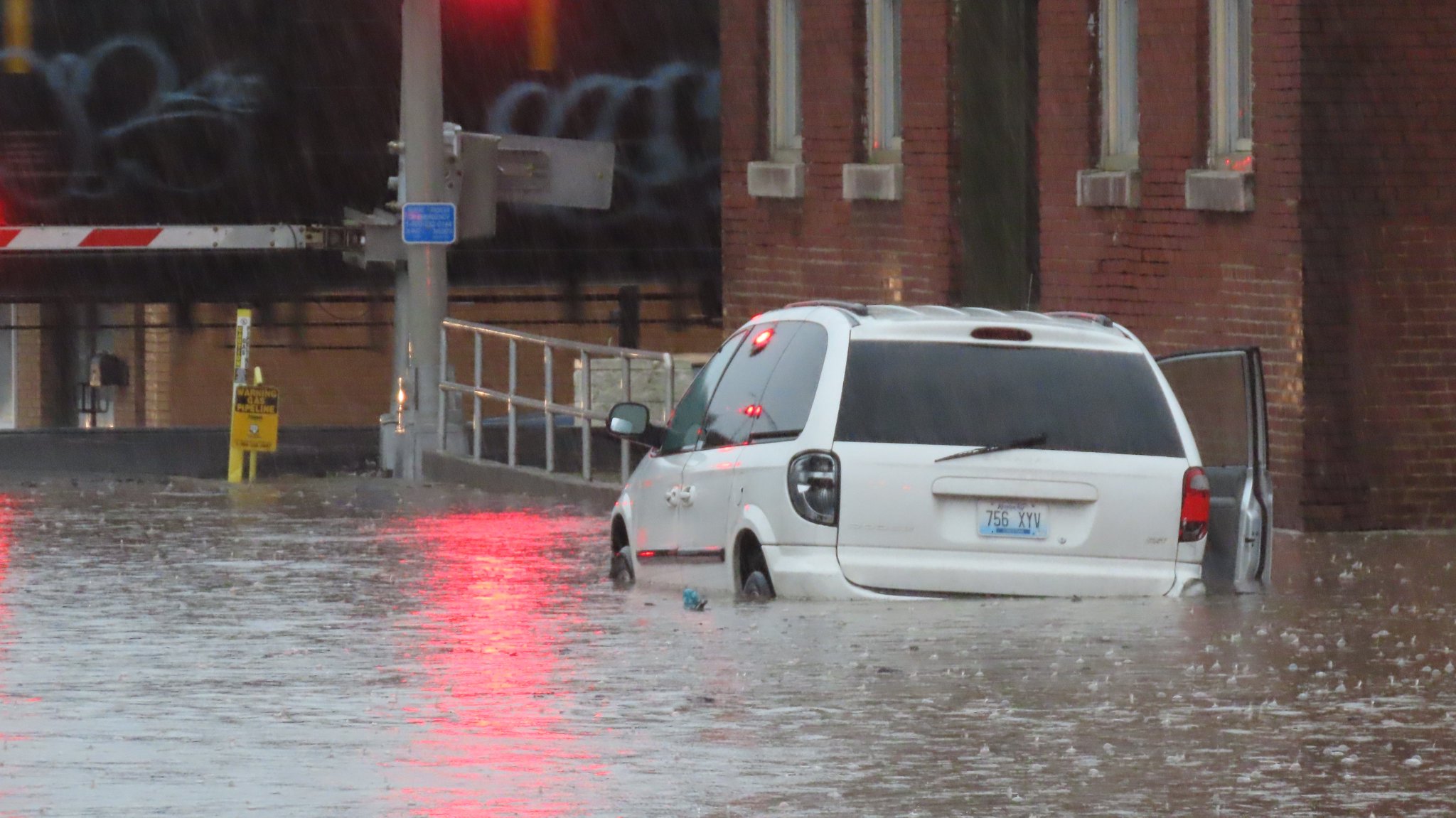
0940 AM FLASH FLOOD 1 NNE HOPKINSVILLE 36.86N 87.49W
02/28/2021 CHRISTIAN KY PUBLIC
MINIVAN BECAME DISABLED IN FLOOD WATERS ON E
9TH ST NEAR THE RAILROAD TRACKS IN
HOPKINSVILLE.
0953 AM FLASH FLOOD 2 NW ELKTON 36.83N 87.18W
02/28/2021 TODD KY PUBLIC
SMALL CREEK ALONG STOKES CHAPEL ROAD IS OUT
OF ITS BANKS AND FLOODING THE ROAD. FIELDS
AND YARDS FLOODING. REPORT FROM MPING.
1000 AM FLASH FLOOD 3 E MURRAY 36.62N 88.26W
02/28/2021 CALLOWAY KY BROADCAST MEDIA
BROOKFIELD LANE IN MURRAY NEARLY COMPLETELY
SUBMERGED IN WATER, DEEP IN SOME AREAS.
1026 AM FLASH FLOOD 2 NW MURRAY 36.63N 88.33W
02/28/2021 CALLOWAY KY TRAINED SPOTTER
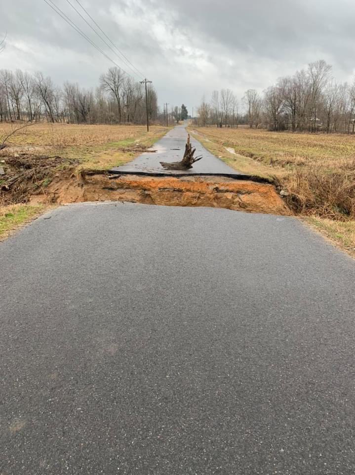
SEVERAL ROADS UNDER WATER. PART OF BAILY
ROAD WASHED AWAY.
1026 AM FLASH FLOOD 1 NNW MURRAY 36.62N 88.32W
02/28/2021 CALLOWAY KY TRAINED SPOTTER
SOME CARS HALFWAY SUBMERGED UNDER WATER ON
121 BYPASS CLOSE TO CSFB CENTER.
1047 AM FLASH FLOOD 2 S WINGO 36.61N 88.73W
02/28/2021 GRAVES KY TRAINED SPOTTER
A PORTION OF WINGO ROAD IN GRAVES COUNTY
COMPLETELY WASHED AWAY.
0218 PM HEAVY RAIN 8 NE MURRAY 36.69N 88.21W
02/28/2021 M3.80 INCH CALLOWAY KY BROADCAST MEDIA
STORM TOTAL SO FAR. NOTICED RAILROAD TRACKS
WERE WASHED OUT AT HWY 80 CROSSING NEAR
MURRAY.
0225 PM FLASH FLOOD 1 ENE ELKTON 36.81N 87.15W
02/28/2021 TODD KY EMERGENCY MNGR
EVACUATIONS UNDERWAY ON WATER STREET, EAST
MAIN STREET AND DON DRIVE IN ELTKON. WATER
UP TO AND UNDER STRUCTURES, BUT NOT INSIDE
YET. NORTH MAIN STREET IS CLOSED COMING INTO
ELKTON. ELK FORK ROAD IS ALSO CLOSED.
0430 PM FLASH FLOOD 6 W PEMBROKE 36.76N 87.47W
02/28/2021 CHRISTIAN KY EMERGENCY MNGR
HWY 41 HAS BEEN CLOSED SOUTH OF HOPKINSVILLE
NEAR NOVADELL GOLF COURSE. ROAD IS
IMPASSABLE DUE TO HIGH WATER.
0634 PM FLASH FLOOD MURRAY 36.61N 88.31W
02/28/2021 CALLOWAY KY TRAINED SPOTTER
MANY ROADS STILL FLOODED DUE TO THE ONGOING
EVENING RAINS. STORM TOTAL RAINFALL 5.05
INCHES.
0700 AM HEAVY RAIN 1 ENE MURRAY 36.62N 88.30W
03/01/2021 M5.64 INCH CALLOWAY KY PUBLIC
2 DAY STORM TOTAL RAINFALL. 0.6 INCH THE
FIRST DAY, 5.04 INCHES THE SECOND.
Flash Flood Emergency - Todd County Kentucky
In coordination with local emergency management, the NWS Paducah office issued a Flash Flood Emergency for Todd County Kentucky during the afternoon on February 28th. Numerous roads were under high water and evacuations were underway at several houses along Water Street. Here is the text from the Flash Flood Emergency:
BULLETIN - EAS ACTIVATION REQUESTED
Flash Flood Warning
National Weather Service Paducah KY
250 PM CST Sun Feb 28 2021

...FLASH FLOOD EMERGENCY FOR CENTRAL TODD COUNTY...INCLUDING
ELKTON...

The National Weather Service in Paducah has issued a

* Flash Flood Warning for...
  Todd County in south central Kentucky...

* Until 900 PM CST Sunday.

* At 250 PM CST, emergency management reported evacuation of several
  homes in Elkton. Widespread flash flooding of small streams across
  both rural and urban areas is occurring. Between 4 and 6 inches of
  rain have fallen. Additional rounds of heavy rain are expected to
  move through Todd County through early this evening, which will
  only make the ongoing flooding situation worse.

  This is a FLASH FLOOD EMERGENCY for Central Todd County...
  including Elkton. This is a PARTICULARLY DANGEROUS SITUATION. SEEK
  HIGHER GROUND NOW!

  HAZARD...Life threatening flash flooding. Thunderstorms
           producing flash flooding.

  SOURCE...Emergency management.

  IMPACT...This is a PARTICULARLY DANGEROUS SITUATION. SEEK
           HIGHER GROUND NOW! Life threatening flash flooding of
           low water crossings, small creeks and streams, urban
           areas, highways, streets and underpasses.

* Some locations that will experience flash flooding include...
  Elkton, Clarksville, Guthrie, Trenton, Allegre, Justice,
  Allensville and Clifty.

PRECAUTIONARY/PREPAREDNESS ACTIONS...

Move to higher ground now! This is an extremely dangerous and
life-threatening situation. Do not attempt to travel unless you are
fleeing an area subject to flooding or under an evacuation order.

Turn around, don`t drown when encountering flooded roads. Most flood
deaths occur in vehicles.

&&

LAT...LON 3707 8726 3707 8725 3706 8725 3704 8725
      3704 8726 3704 8713 3706 8705 3679 8706
      3677 8705 3675 8706 3664 8706 3664 8734

FLASH FLOOD...OBSERVED
FLASH FLOOD DAMAGE THREAT...CATASTROPHIC
EXPECTED RAINFALL...0.5-1.5 INCHES IN 1 HOUR

$$

DWS
 |
Media use of NWS Web News Stories is encouraged! Please acknowledge the NWS as the source of any news information accessed from this site. |
|

