Overview
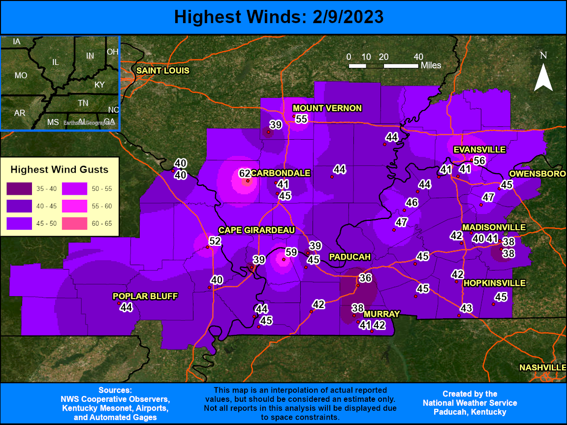
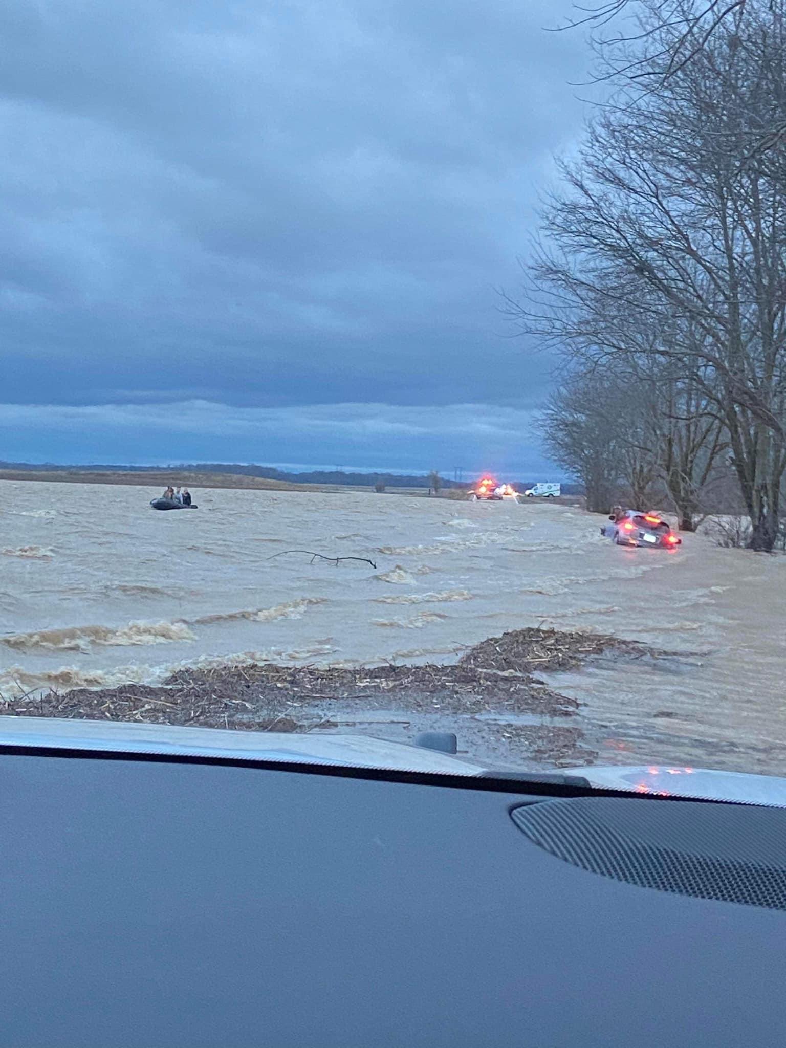
A storm system impacted the region with a multitude of hazards on February 8th and 9th, 2023. Heavy rainfall amounts of 2 to 3+ inches led to flooding issues across portions of southern Illinois and southeast Missouri. Numerous Flood Advisories were in effect throughout this event. A water rescue was performed in Hamilton County, Illinois on the morning of the 9th. During the evening on February 8th, a few thunderstorms developed that produced strong winds. After midnight, what instability we had seemed to dissipate, but a line of heavier showers was able to mix down some of the stronger winds aloft allowing for scattered tree damage and power outages to occur. After the rain ended, strong gradient winds developed during the early morning and continued through the day on the 9th. Most locations observed peak wind gusts of 40 to 50 mph, but there were some locations that experienced wind gusts of 55 to 60 mph. The highest observed gusts were 62 mph at Carbondale, IL and 59 mph at the Ballard County, KY Mesonet.Strong Winds
Strong gradient winds developed after midnight and continued into the day on February 9th. Some of the highest gusts were associated with the last line of heavy showers that moved through. Other locations observed their highest winds after the rain exited during the early to mid morning hours. The strong winds occurred due to a rapidly deepening low pressure system that moved from near Springfield, MO to Chicago, IL. A tight pressure gradient developed across our region and the strong winds just off the surface were able to mix down. These winds produced scattered tree damage and caused some power outages as well. At the peak, several thousands customers were without power across southern Illinois. Isolated power outages also occurred in our other three states. Here is a public information statement with the highest peak wind gusts across the region.
 |
Photos
 |
%20courtesy%20of%20Allison%20Wilson.jpg) |
 |
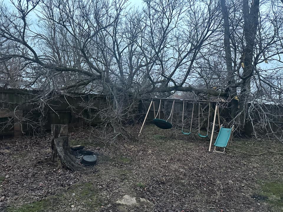 |
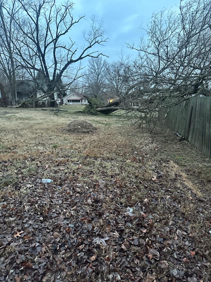
| Hamilton County water rescue, courtesy of Nick Hausen | Ingram Hill Road in Saline County, (along Saline Creek) courtesy of Allison Wilson | Tree damage in Hendron, KY, courtesy of Michael Brewer | Tree damage in West Frankfort, IL, courtesy of Jordan Osterhout |
 |
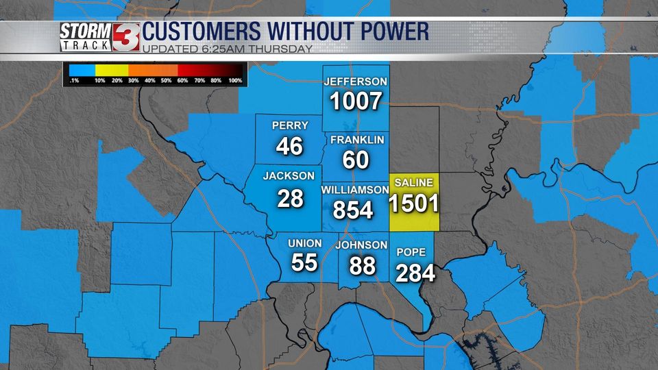 |
| Tree uprooted in West Frankfort, IL, courtesy of Jordan Osterhout | Customers without power at 5 AM on February 9th, courtesy of Nick Hausen |
Radar
Click here for a radar loop of this event.
The rain started across southeast Missouri and far west Kentucky early on the morning of February 8th. It eventually lifted further north reaching the I-64 corridor by late afternoon and continued into the evening and overnight. The final line of showers moved from west to east between 2 and 6 AM on February 9th. This last band was able to mix down some of the stronger winds that had developed just off the surface after midnight. They were basically severe showers with no lightning noted with them. Wind gusts of 40 to 60 mph occurred at most locations as this band moved through.
Storm Reports
PRELIMINARY LOCAL STORM REPORT...SUMMARY NATIONAL WEATHER SERVICE PADUCAH KY 308 PM CST THU FEB 9 2023 ..TIME... ...EVENT... ...CITY LOCATION... ...LAT.LON... ..DATE... ....MAG.... ..COUNTY LOCATION..ST.. ...SOURCE.... ..REMARKS.. 0955 AM NON-TSTM WND GST NEWBURGH 37.95N 87.40W 02/09/2023 M55 MPH WARRICK IN TRAINED SPOTTER 0850 AM NON-TSTM WND GST 1 SE ENERGY 37.77N 89.02W 02/09/2023 M41 MPH WILLIAMSON IL AWOS AWOS STATION KMWA MARION IL. 0850 AM HEAVY RAIN 1 ESE WEST FRANKFORT 37.90N 88.92W 02/09/2023 M2.92 INCH FRANKLIN IL MESONET MESONET STATION AS076 W.FRANKFORT. 0839 AM HEAVY RAIN GRAYVILLE 38.26N 88.00W 02/09/2023 M3.15 INCH WHITE IL MESONET MESONET STATION GW1251 GRAYVILLE. 0835 AM HEAVY RAIN CRAINVILLE 37.75N 89.06W 02/09/2023 M3.14 INCH WILLIAMSON IL MESONET MESONET STATION FW7109 CRAINVILLE. 0830 AM FLASH FLOOD 4 NNE BROUGHTON 37.98N 88.43W 02/09/2023 HAMILTON IL BROADCAST MEDIA WATER RESCUE ALONG NORRIS CITY ROAD AT THE NORTH FORK SALINE RIVER BRIDGE. EXACT TIME UNKNOWN BUT IT DID OCCUR SOMETIME BETWEEN SUNRISE AND 8:30 AM. 0830 AM NON-TSTM WND GST 4 ESE HENDERSON 37.82N 87.51W 02/09/2023 M40 MPH HENDERSON KY MESONET MESONET STATION GRHM HENDERSON KY 5 E. 0815 AM NON-TSTM WND GST 1 ENE BRECKINRIDGE CENT 37.69N 87.84W 02/09/2023 M41 MPH UNION KY MESONET MESONET STATION FRNY MORGANFIELD KY 4 E. 0815 AM HEAVY RAIN 4 WNW POPLAR BLUFF 36.78N 90.47W 02/09/2023 M2.69 INCH BUTLER MO COCORAHS COCORAHS STATION MO-BU-3 POPLAR BLUFF 3.7 WNW. 0805 AM NON-TSTM WND GST 4 NE MARION 37.38N 88.04W 02/09/2023 M47 MPH CRITTENDEN KY MESONET MESONET STATION RPTN MARION KY 4 NE. 0800 AM HEAVY RAIN 4 NW TUNNEL HILL 37.56N 88.88W 02/09/2023 M3.40 INCH JOHNSON IL TRAINED SPOTTER STORM TOTAL RAINFALL. 0757 AM HEAVY RAIN 5 ENE THEBES 37.25N 89.38W 02/09/2023 M2.80 INCH ALEXANDER IL MESONET MESONET STATION BNRI2 BEAN RIDGE IL. 0755 AM HEAVY RAIN 5 SW MARION 37.68N 89.00W 02/09/2023 M2.82 INCH WILLIAMSON IL MESONET MESONET STATION COWI2 CRAB ORCHARD IL. 0753 AM HEAVY RAIN 3 NE DONIPHAN 36.65N 90.78W 02/09/2023 M2.98 INCH RIPLEY MO MESONET MESONET STATION DFSM7 DONIPHAN MO. 0730 AM NON-TSTM WND GST 5 WSW HENDERSON 37.82N 87.67W 02/09/2023 M40 MPH HENDERSON KY AWOS AWOS STATION KEHR HENDERSON KY. 0730 AM HEAVY RAIN 1 SSE MAKANDA 37.60N 89.23W 02/09/2023 M3.23 INCH JACKSON IL COCORAHS COCORAHS STATION IL-JK-32 MAKANDA 1.5 SSE. 0724 AM NON-TSTM WND GST 2 N MELODY HILL 38.05N 87.52W 02/09/2023 M45 MPH VANDERBURGH IN ASOS ASOS STATION KEVV EVANSVILLE IN. 0724 AM HEAVY RAIN 1 SW CRAINVILLE 37.74N 89.08W 02/09/2023 M2.98 INCH WILLIAMSON IL COCORAHS COCORAHS STATION IL-WM-14 CARTERVILLE IL 1.6 SSE. 0724 AM HEAVY RAIN 1 SW CRAINVILLE 37.74N 89.08W 02/09/2023 M2.98 INCH WILLIAMSON IL COCORAHS COCORAHS STATION IL-WM-14 CARTERVILLE IL 1.6 SSE. 0720 AM NON-TSTM WND DMG HERNDON 36.71N 87.60W 02/09/2023 CHRISTIAN KY TRAINED SPOTTER LARGE TREE BRANCH FELL ONTO DECK AND PART OF THE HOUSE. IT OCCURRED SOMETIME DURING THE NIGHT. 0720 AM HEAVY RAIN ALBION 38.38N 88.06W 02/09/2023 M2.70 INCH EDWARDS IL TRAINED SPOTTER 24 HOUR STORM TOTAL. 0716 AM HEAVY RAIN 6 WNW NORRIS CITY 38.02N 88.42W 02/09/2023 M2.82 INCH HAMILTON IL COCORAHS COCORAHS STATION IL-HM-4 NORRIS CITY, IL 7 NW. 0708 AM HEAVY RAIN 5 ESE SIMPSON 37.44N 88.67W 02/09/2023 M2.95 INCH POPE IL MESONET MESONET STATION DSFI2 DIXON SPRINGS IL. 0700 AM NON-TSTM WND GST 4 NNE WINGO 36.70N 88.72W 02/09/2023 M42 MPH GRAVES KY MESONET MESONET STATION PRYB MAYFIELD KY 6 SW. 0700 AM HEAVY RAIN 2 W SIKESTON 36.88N 89.62W 02/09/2023 M2.50 INCH SCOTT MO CO-OP OBSERVER CO-OP OBSERVER STATION SKSM7 SIKESTON MO POWER STATION. 0700 AM HEAVY RAIN 1 ENE CARBONDALE 37.73N 89.20W 02/09/2023 M2.50 INCH JACKSON IL CO-OP OBSERVER CO-OP OBSERVER STATION MDHI2 CARBONDALE IL SEWAGE PLANT. 0700 AM HEAVY RAIN 1 E ALBION 38.38N 88.03W 02/09/2023 M2.52 INCH EDWARDS IL COCORAHS COCORAHS STATION IL-EW-4 ALBION IL 1.4 E. 0700 AM HEAVY RAIN 2 S RALEIGH 37.80N 88.53W 02/09/2023 M2.59 INCH SALINE IL COCORAHS COCORAHS STATION IL-SL-1 HARRISBURG IL 4.6 NNE. 0700 AM HEAVY RAIN 1 N CAIRO 37.01N 89.18W 02/09/2023 M2.62 INCH ALEXANDER IL COCORAHS COCORAHS STATION IL-AL-2 CAIRO, IL. 0700 AM HEAVY RAIN ALBION 38.37N 88.06W 02/09/2023 M2.70 INCH EDWARDS IL COCORAHS COCORAHS STATION IL-EW-3 ALBION, IL. 0700 AM HEAVY RAIN 2 NNE PHILLIPSTOWN 38.17N 88.01W 02/09/2023 M2.71 INCH WHITE IL COCORAHS COCORAHS STATION IL-WH-4 CROSSVILLE IL 3.0 E. 0700 AM HEAVY RAIN 4 NNW MAKANDA 37.67N 89.26W 02/09/2023 M2.80 INCH JACKSON IL COCORAHS COCORAHS STATION IL-JK-29 CARBONDALE 4.4 SW. 0700 AM HEAVY RAIN 1 SSE COBDEN 37.52N 89.25W 02/09/2023 M3.04 INCH UNION IL COCORAHS COCORAHS STATION IL-UN-6 COBDEN IL 0.8 SSE. 0700 AM HEAVY RAIN 2 N CAPE GIRARDEAU 37.34N 89.55W 02/09/2023 M3.08 INCH CAPE GIRARDEAU MO COCORAHS COCORAHS STATION MO-CG-8 CAPE GIRARDEAU MO 2.3 N. 0700 AM HEAVY RAIN DIEHLSTADT 36.96N 89.43W 02/09/2023 M3.15 INCH SCOTT MO TRAINED SPOTTER EVENT RAINFALL TOTAL. 0700 AM HEAVY RAIN 4 ENE COBDEN 37.56N 89.19W 02/09/2023 M3.15 INCH UNION IL COCORAHS COCORAHS STATION IL-UN-8 COBDEN IL 4 ENE. 0700 AM HEAVY RAIN 2 SSW MAKANDA 37.59N 89.25W 02/09/2023 M3.21 INCH UNION IL COCORAHS COCORAHS STATION IL-UN-12 COBDEN 4.2 N. 0700 AM HEAVY RAIN 2 W CREAL SPRINGS 37.61N 88.88W 02/09/2023 M3.26 INCH WILLIAMSON IL COCORAHS COCORAHS STATION IL-WM-18 CREAL SPRINGS 2.2 W. 0700 AM HEAVY RAIN 4 NE GOREVILLE 37.59N 88.92W 02/09/2023 M3.34 INCH JOHNSON IL COCORAHS COCORAHS STATION IL-JH-2 GOREVILLE 3.8 NE. 0700 AM HEAVY RAIN 2 ESE CARBONDALE 37.72N 89.19W 02/09/2023 M3.40 INCH JACKSON IL COCORAHS COCORAHS STATION IL-JK-33 CARBONDALE 1.7 ESE. 0700 AM HEAVY RAIN 5 NNW OXLY 36.67N 90.73W 02/09/2023 M3.55 INCH RIPLEY MO COCORAHS COCORAHS STATION MO-RP-8 FAIRDEALING 6.0 W. 0700 AM NON-TSTM WND DMG HENDRON 37.04N 88.63W 02/09/2023 MCCRACKEN KY TRAINED SPOTTER CORRECTS PREVIOUS NON-TSTM WND DMG REPORT FROM HERNDON, KY. LARGE TREE BRANCH FELL ONTO DECK AND PART OF THE HOUSE. IT OCCURRED SOMETIME DURING THE NIGHT. 0700 AM HEAVY RAIN COBDEN 37.53N 89.25W 02/09/2023 M3.04 INCH UNION IL TRAINED SPOTTER STORM TOTAL RAINFALL. 0652 AM NON-TSTM WND GST 3 E CARMI 38.08N 88.12W 02/09/2023 M44 MPH WHITE IL AWOS AWOS STATION KCUL CARMI IL. 0650 AM NON-TSTM WND GST 2 WSW CENTRAL CITY 37.29N 87.16W 02/09/2023 M40 MPH MUHLENBERG KY MESONET MESONET STATION CCTY GREENVILLE KY 6 N. 0650 AM TSTM WND GST CENTRAL CITY 37.30N 87.13W 02/09/2023 M47 MPH MUHLENBERG KY TRAINED SPOTTER EAST BROAD STREET IN CENTRAL CITY KENTUCKY. MEASURED WIND GUST 46.7 MPH. NUMEROUS SMALL LIMBS DOWN WITH ONE 8 DIAMETER LIMB DOWN. 0645 AM NON-TSTM WND DMG EVANSVILLE 37.98N 87.54W 02/09/2023 VANDERBURGH IN TRAINED SPOTTER TREE DOWN ON A HOUSE ALONG COKER AVE IN EVANSVILLE. TIME ESTIMATED. LIKELY ASSOCIATED WITH GRADIENT WINDS BEHIND THE LINE OF SHOWERS. 0610 AM NON-TSTM WND GST 7 NNW HOPKINSVILLE 36.95N 87.52W 02/09/2023 M41 MPH CHRISTIAN KY MESONET MESONET STATION PGHL HOPKINSVILLE KY 6 N. 0602 AM NON-TSTM WND GST 2 SE HEATH 37.07N 88.77W 02/09/2023 M45 MPH MCCRACKEN KY ASOS ASOS STATION KPAH PADUCAH KY. 0600 AM HEAVY RAIN CAPE GIRARDEAU 37.31N 89.55W 02/09/2023 M2.80 INCH CAPE GIRARDEAU MO TRAINED SPOTTER 0533 AM NON-TSTM WND GST 4 SW OWENSBORO 37.72N 87.17W 02/09/2023 M40 MPH DAVIESS KY AWOS AWOS STATION KOWB OWENSBORO KY. 0530 AM TSTM WND GST 4 NW CALHOUN 37.59N 87.32W 02/09/2023 M47 MPH MCLEAN KY MESONET MESONET STATION PVRT CALHOUN KY 5 NW. 0500 AM NON-TSTM WND DMG 4 NW DALE 38.20N 87.04W 02/09/2023 WARRICK IN TRAINED SPOTTER TREE FELL ON POWER LINE ALONG COUNTY ROAD 1200 SOUTH ALONG THE DUBOIS/WARRICK COUNTY LINE. POWER OUTAGE IN HOLLAND FROM 6 AM TO 9:45 AM EST. 0500 AM NON-TSTM WND GST 6 S WOLF ISLAND 36.66N 89.20W 02/09/2023 M44 MPH MISSISSIPPI MO MESONET MESONET STATION EW4994 DORENA MO. 0455 AM NON-TSTM WND GST 2 NNE SIKESTON 36.90N 89.57W 02/09/2023 M40 MPH SCOTT MO AWOS AWOS STATION KSIK SIKESTON MO. 0450 AM NON-TSTM WND GST 2 ENE HICKMAN 36.57N 89.16W 02/09/2023 M45 MPH FULTON KY MESONET MESONET STATION HCKM HICKMAN KY 2 E. 0450 AM TSTM WND GST 2 ESE PRINCETON 37.10N 87.86W 02/09/2023 M45 MPH CALDWELL KY MESONET MESONET STATION PRNC PRINCETON KY 2 SE. 0435 AM TSTM WND GST 2 E STURGIS 37.54N 87.95W 02/09/2023 M46 MPH UNION KY MESONET MESONET STATION KTWT STURGIS MUNICIPAL AIRPORT. 0409 AM NON-TSTM WND GST 1 WSW RALEIGH 37.82N 88.55W 02/09/2023 M44 MPH SALINE IL AWOS AWOS STATION KHSB HARRISBURG IL. 0356 AM TSTM WND GST 2 E MOUNT VERNON 38.32N 88.87W 02/09/2023 M55 MPH JEFFERSON IL AWOS PEAK WIND GUST AT KMVN MT VERNON IL AWOS ASSOCIATED WITH PASSING LINE OF SHOWERS. 0355 AM NON-TSTM WND GST 5 SW MARION 37.68N 89.00W 02/09/2023 M45 MPH WILLIAMSON IL MESONET MESONET STATION COWI2 CRAB ORCHARD IL. 0355 AM TSTM WND DMG 4 W MCLEANSBORO 38.08N 88.61W 02/09/2023 HAMILTON IL EMERGENCY MNGR REPORT OF TREE DOWN AT INTERSECTION OF IL ROUTE 14 AND COUNTY ROAD 525E WEST OF MCLEANSBORO. TIME ESTIMATED BY RADAR. 0355 AM TSTM WND DMG BLUFORD 38.33N 88.74W 02/09/2023 JEFFERSON IL BROADCAST MEDIA PUBLIC REPORT OF SHINGLE DAMAGE TO A HOME IN BLUFORD FROM PASSING LINE OF SHOWERS. TIME ESTIMATED FROM RADAR. REPORT RELAYED BY WSIL TV. 0355 AM TSTM WND DMG ELDORADO 37.81N 88.44W 02/09/2023 SALINE IL BROADCAST MEDIA PUBLIC REPORT OF FLAG POLE BENT OVER AND BROKEN AS LINE OF SHOWERS MOVED THROUGH. TIME ESTIMATED FROM RADAR. REPORT RELAYED BY WSIL TV. 0350 AM TSTM WND DMG HARRISBURG 37.74N 88.54W 02/09/2023 SALINE IL UTILITY COMPANY TIME ESTIMATED BY RADAR. POWER OUTAGES THROUGHOUT SALINE COUNTY DUE TO BAND OF SHOWERS MOVED THROUGH SHORTLY BEFORE 4 AM. ROUGHLY 1778 CUSTOMERS STILL WITHOUT POWER AT 630 AM. 0340 AM TSTM WND DMG HARRISBURG 37.74N 88.55W 02/09/2023 SALINE IL PUBLIC TREES DOWN NEAR HARRISBURG. REPORT RECEIVED VIA SOCIAL MEDIA. 0340 AM TSTM WND DMG HARRISBURG 37.74N 88.55W 02/09/2023 SALINE IL PUBLIC TREES DOWN NEAR HARRISBURG. REPORT RECEIVED VIA SOCIAL MEDIA. 0325 AM NON-TSTM WND GST 4 SW CADIZ 36.83N 87.86W 02/09/2023 M45 MPH TRIGG KY MESONET MESONET STATION CADZ CADIZ KY 4 SW. 0325 AM TSTM WND DMG WEST FRANKFORT 37.90N 88.93W 02/09/2023 FRANKLIN IL BROADCAST MEDIA PUBLIC REPORT OF A TREE DOWN FROM PASSING LINE OF SHOWERS. TIME ESTIMATED FROM RADAR. REPORT RELAYED BY WSIL TV. 0325 AM TSTM WND DMG LONE OAK 37.03N 88.66W 02/09/2023 MCCRACKEN KY PUBLIC 1-INCH TREE LIMBS BROKEN. SHINGLES BLOWN OFF. WIND GUSTS ASSOCIATED WITH PASSING LINE OF SHOWERS. TIME ESTIMATED FROM RADAR. 0322 AM TSTM WND DMG CARBONDALE 37.73N 89.22W 02/09/2023 JACKSON IL TRAINED SPOTTER TREE DAMAGE REPORTED IN THE CARBONDALE AREA DUE TO STRONG WIND GUSTS WITH PASSING LINE OF SHOWERS. WINDS WERE ESTIMATED AT 60 MPH. 0320 AM TSTM WND DMG WEST FRANKFORT 37.90N 88.93W 02/09/2023 FRANKLIN IL BROADCAST MEDIA LARGE TREE UPROOTED AND ON A FENCE. TIME ESTIMATED BY RADAR WITH A LINE OF SHOWERS MOVING THROUGH. 0317 AM TSTM WND GST 3 SSW DE SOTO 37.78N 89.25W 02/09/2023 M62 MPH JACKSON IL ASOS PEAK WIND GUST AT KMDH CARBONDALE IL ASOS ASSOCIATED WITH PASSING LINE OF SHOWERS. 0310 AM TSTM WND DMG VIENNA 37.41N 88.89W 02/09/2023 JOHNSON IL BROADCAST MEDIA PUBLIC REPORT OF DAMAGE TO SIDING ON A HOME IN VIENNA. WINDS ASSOCIATED WITH PASSING LINE OF SHOWERS. TIME ESTIMATED FROM RADAR. REPORT RELAYED BY WSIL TV. 0305 AM NON-TSTM WND GST 1 W MURRAY 36.61N 88.34W 02/09/2023 M41 MPH CALLOWAY KY MESONET MESONET STATION MRRY MURRAY KY 1 W. 0253 AM TSTM WND GST 3 WNW SCOTT CITY 37.23N 89.58W 02/09/2023 M52 MPH SCOTT MO ASOS PEAK WIND GUST AT KCGI CAPE GIRARDEAU MO ASOS ASSOCIATED WITH PASSING LINE OF SHOWERS. 0235 AM NON-TSTM WND GST 3 NNE LITHIUM 37.87N 89.87W 02/09/2023 M40 MPH PERRY MO AWOS AWOS STATION KPCD PERRYVILLE MO. 0230 AM NON-TSTM WND GST 4 NE TRENTON 36.76N 87.21W 02/09/2023 M45 MPH TODD KY MESONET MESONET STATION ZION ELKTON KY 5 SW. 0230 AM NON-TSTM WND GST CAPE GIRARDEAU 37.31N 89.55W 02/09/2023 M50 MPH CAPE GIRARDEAU MO BROADCAST MEDIA GREATEST WINDS SPEED ACCOMPANIED A LINE OF SHOWERS. 0107 AM NON-TSTM WND GST 5 W ASH HILL 36.77N 90.32W 02/09/2023 M44 MPH BUTLER MO ASOS ASOS STATION KPOF POPLAR BLUFF MO. 1000 PM FLOOD MCLEANSBORO 38.09N 88.53W 02/08/2023 HAMILTON IL EMERGENCY MNGR MARKET ST AND ARMY NAVY STORE RD IN MCLEANSBORO ARE IMPASSABLE DUE TO HIGH WATER. THE DALE BLACKTOP IS ALSO IMPASSABLE. 0900 PM FLOOD 6 SSW MCLEANSBORO 38.01N 88.56W 02/08/2023 HAMILTON IL EMERGENCY MNGR CR 700 NORTH IS IMPASSABLE DUE TO HIGH WATER. HIGHWAY 142 AT CR 1000 NORTH AND AT DIGBY RD IS WATER COVERED, BUT PASSABLE. HIGHWAY 242 AT BLAIRSVILLE RD IS ALSO WATER COVERED, BUT PASSABLE. 0852 PM FLOOD 2 NNW HANAFORD 37.98N 88.85W 02/08/2023 FRANKLIN IL EMERGENCY MNGR AKIN BLACKTOP NEAR AKIN HAS FLOODED. 0831 PM TSTM WND DMG 3 N METROPOLIS 37.20N 88.72W 02/08/2023 MASSAC IL EMERGENCY MNGR LARGE TREE BLOWN DOWN. 0818 PM TSTM WND DMG 1 ENE KEVIL 37.09N 88.87W 02/08/2023 MCCRACKEN KY TRAINED SPOTTER LARGE TREE LIMB BLOWN DOWN. 0724 PM TSTM WND GST ANNISTON 36.83N 89.33W 02/08/2023 M70 MPH MISSISSIPPI MO PUBLIC TIME ESTIMATED FROM RADAR. RELAYED BY KFVS. 0610 PM TSTM WND DMG BERNIE 36.67N 89.97W 02/08/2023 STODDARD MO PUBLIC PART OF A CARPORT WAS DAMAGED. TIME ESTIMATED FROM RADAR. REPORT RELAYED BY KFVS. 0450 PM FLOOD 2 N GRANDIN 36.86N 90.82W 02/08/2023 CARTER MO EMERGENCY MNGR HIGH WATER FROM THE LITTLE BLACK RIVER HAS FLOODED CR 240.
Rain Reports
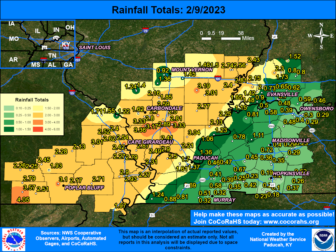
Here is a public information statement containing observed rainfall reports from this event. The graphic below shows the observed rainfall across the region. The heaviest swath was focused across southeast Missouri into southern Illinois. A broad swath of 1.5 to 3 inches occurred and there were several sites over 3". The highest report was 4.05" at a CoCoRaHS station in far southwest Ripley County, Missouri.
 |
 |
Media use of NWS Web News Stories is encouraged! Please acknowledge the NWS as the source of any news information accessed from this site. |
|

