Overview
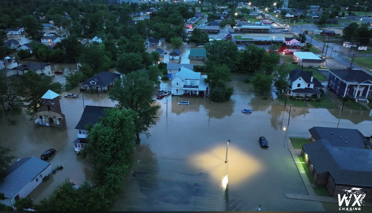
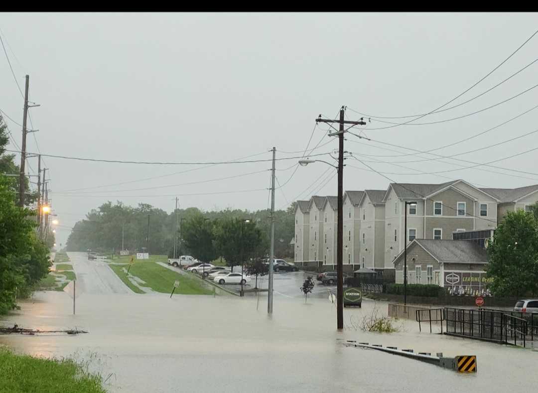
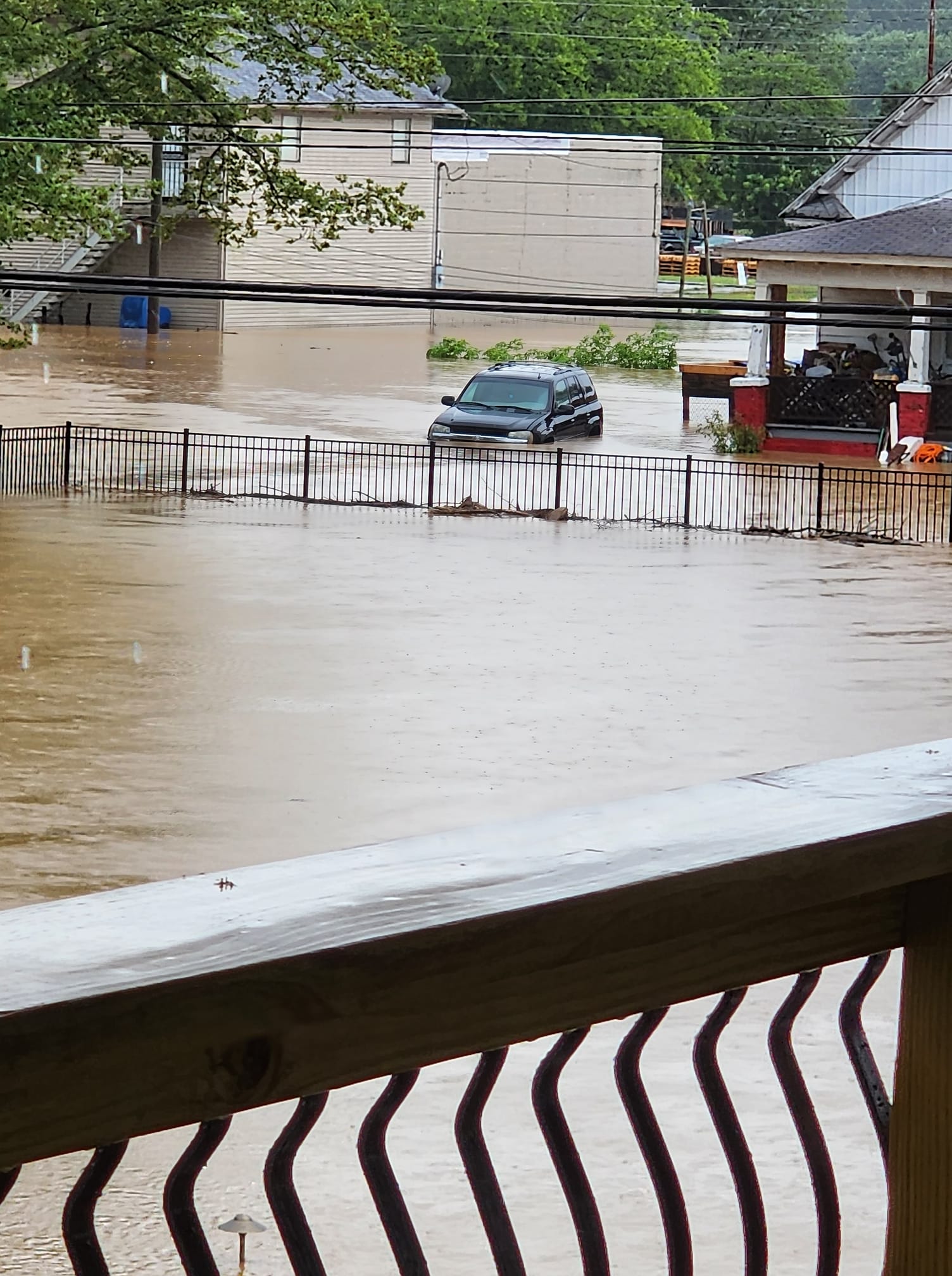
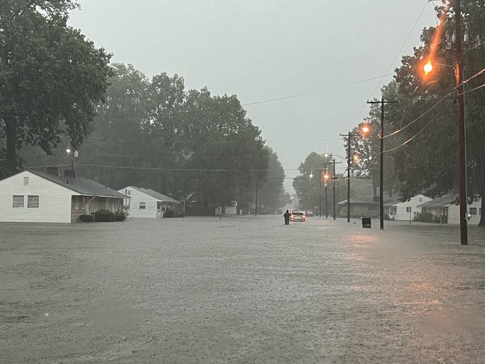
A historic flash flooding event unfolded during the overnight and into the morning hours on July 19, 2023 across far western Kentucky into portions of southern Illinois. Widespread rainfall totals ranging from 6 to 12 inches occurred from Cape Girardeau to Paducah, Mayfield, and Murray. The majority of this rain fell within a 10 hour window between Midnight and 10 AM. Among the hardest hit counties was Graves County, which had not completely recovered from a catastrophic tornado in December of 2021. Widespread flash flooding of roads made travel difficult or impossible for several hours during the peak of the heaviest rainfall in the morning. The city of Mayfield, which bore the brunt of the December 2021 tornado, experienced catastrophic flooding that inundated many homes, businesses, schools, and various other institutions.
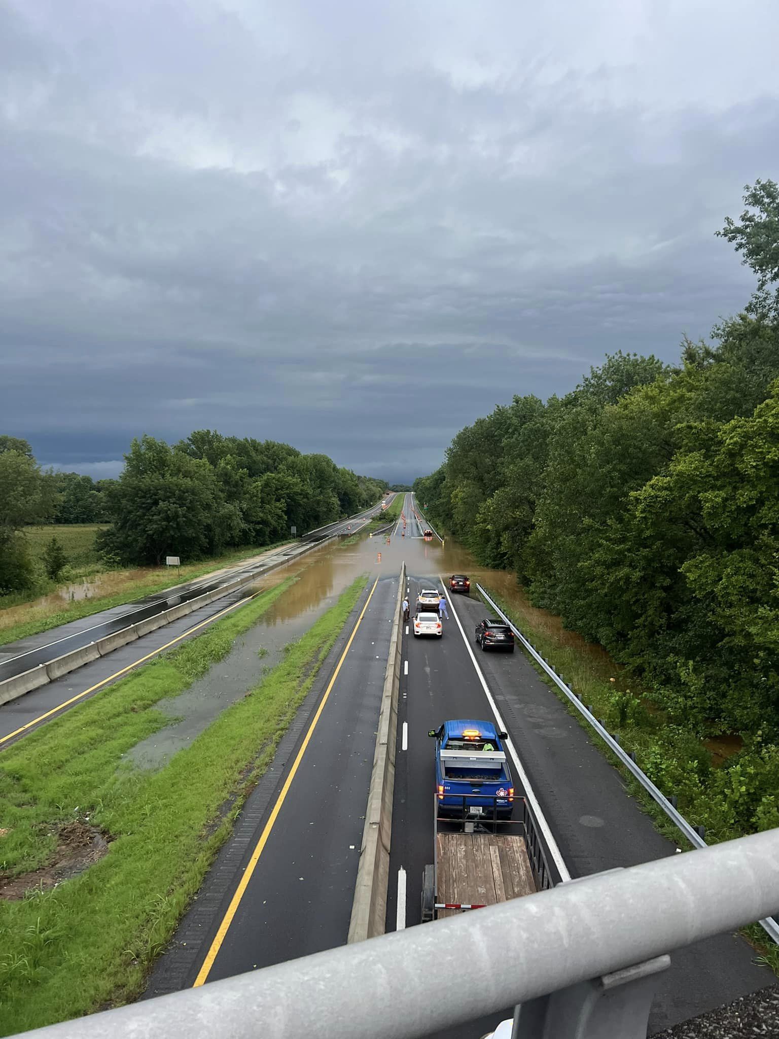
Our office issued 5 Flash Flood Emergencies during this event, including all or portions of Ballard, Carlisle, Hickman, Graves, and McCracken counties in Kentucky and Pulaski county in Illinois. Impacts included numerous water rescues, many homes and businesses inundated by flood waters with some people trapped in their homes, washed out roads, and dozens of roads impassable due to flood waters. At one point a section of I-57 in Pulaski County Illinois and I-69 in Graves County Kentucky were closed due to high water flowing over them. Crop damage was expected to run into the millions of dollars. At one farm alone in southern Graves County, crop damage was estimated around 40,000 dollars.
Flooding
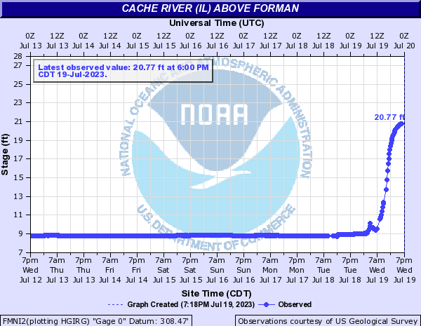
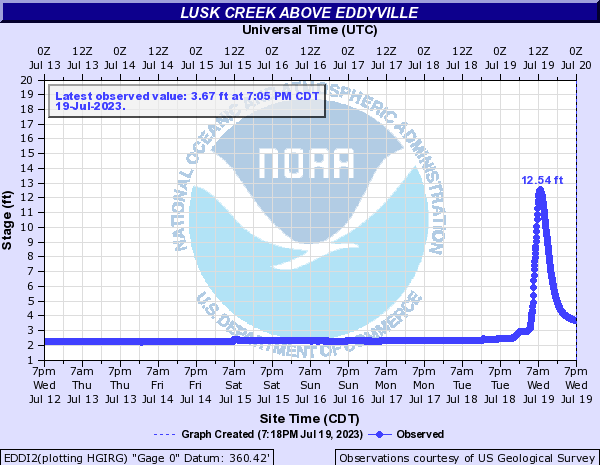
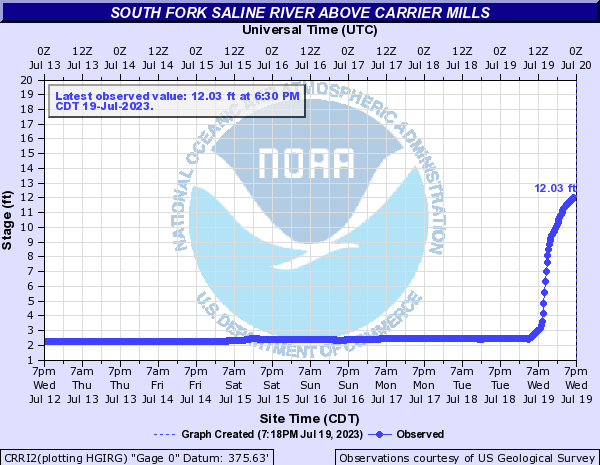
Numerous creeks and smaller rivers experienced significant rises in a very short amount of time. The Ohio River even experienced a notable rise in river levels in a short period of time. The gauge at Cairo, IL jumped over 5 feet in 24 hours, which is something very rarely observed on larger rivers.
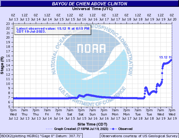
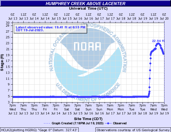
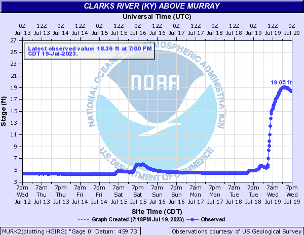
Hydrographs
 |
 |
 |
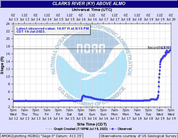 |
| Bayou de Chien above Clinton, KY | Humphrey Creek above La Center, KY | Clarks River above Murray, KY | Clarks River above Almo, KY |
 |
 |
 |
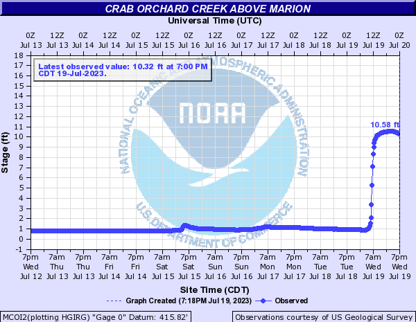 |
| Cache River above Forman, IL | Lusk Creek above Eddyville, IL | South Fork Saline River above Carrier Mills, IL | Crab Orchard Creek above Marion, IL |
County Records
County 1-, 2-, and 3-day record rainfall totals are listed below. The official total in Paducah on July 19th was 6.95", making it the 2nd highest single-day rainfall on record for the city (behind the 7.49" on September 5, 1985 from the remnants of Hurricane Elena).
| County | Site | Days | Rainfall |
| Alexander, IL | Cairo 3 N (COOP) | 2 | 7.83 in. |
| Ballard, KY | La Center 5 NNE (KY Mesonet) | 1 | 9.15 in. |
| Ballard, KY | La Center 5 NNE (KY Mesonet) | 2 | 9.73 in. |
| Ballard, KY | La Center 5 NNE (KY Mesonet) | 3 | 10.45 in. |
| Calloway, KY | Murray 1 W (KY Mesonet) | 1 | 6.98 in. |
| Graves, KY | Mayfield 6 SW (KY Mesonet) | 1 | 9.62 in. |
| Johnson, IL | Goreville 3.8 NE (CoCoRaHS) | 1 | 6.99 in. |
| Pulaski, IL | Ullin 0.4 WSW (CoCoRaHS) | 2 | 8.68 in. |
| Pulaski, IL | Ullin 0.4 WSW (CoCoRaHS) | 3 | 9.35 in. |
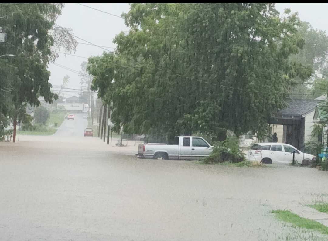
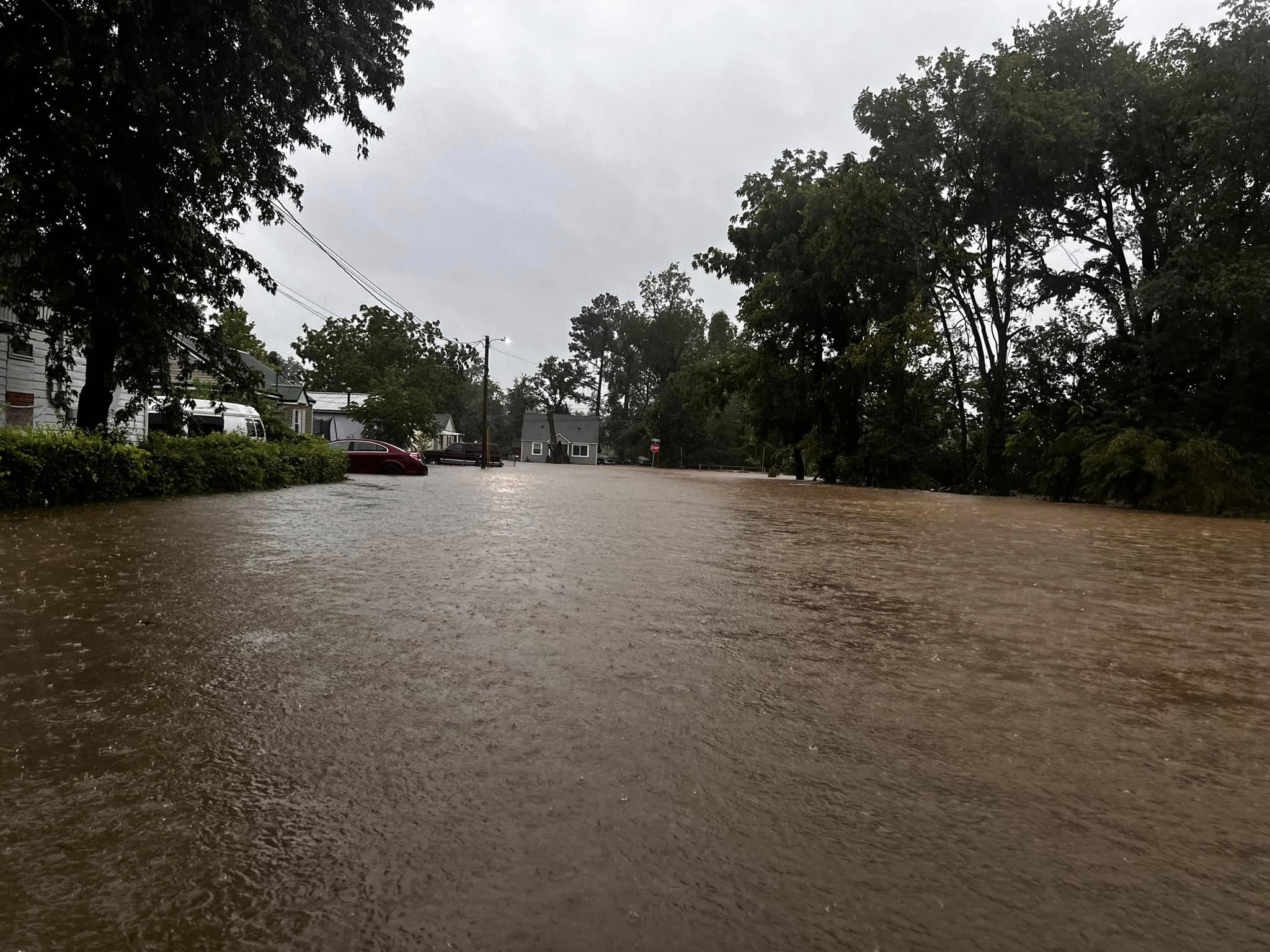
Photos
 |
 |
 |
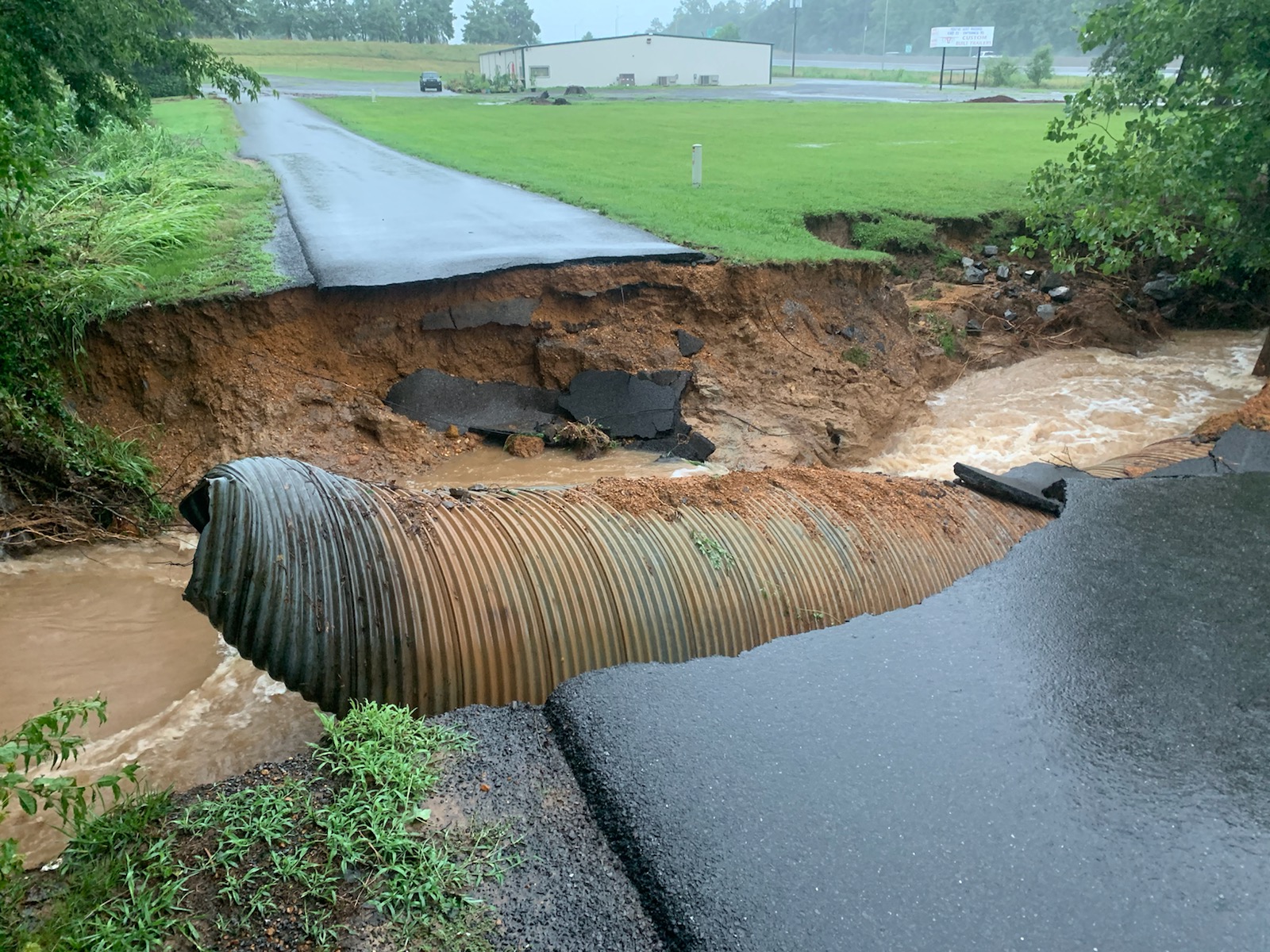 |
| Flooding on 10th Street in Mayfield, KY courtesy of Beau Dodson | Flooding in Mayfield, KY courtesy of Noah Bergren | Flooding in Mayfield, KY | Washed out culvert in Mayfield, KY courtesy of KFVS-12 Weather |
 |
 |
 |
 |
| Flooding on 16th Street in Murray, KY | Flooding on Central Ave in Fulton, KY courtesy of Sherry Cook-Pyatt | Flooding in Paducah, KY | Flooding along Purchase Parkway in KY |
Radar
Here is radar loop for the event.
Storms rapidly developed after 10 PM on the 18th and set up in a northwest to southeast line across southern Illinois, far west Kentucky, and along the Mississippi River in southeast Missouri. They continued to back build and train over the same areas through the overnight and into the morning of the 19th. By late morning into midday, rainfall rates finally started to decrease substantially.
Storm Reports
Preliminary Local Storm Report...Summary National Weather Service Paducah KY 404 PM CDT Thu Jul 20 2023 ..TIME... ...EVENT... ...CITY LOCATION... ...LAT.LON... ..DATE... ....MAG.... ..COUNTY LOCATION..ST.. ...SOURCE.... ..REMARKS.. 0900 AM Rain 6 ENE Hazel 36.54N 88.22W 07/20/2023 M6.76 inch Calloway KY Mesonet Mesonet station FW3304 New Concord KY 2 day rainfall total. 0845 AM Rain 6 ENE Hazel 36.54N 88.22W 07/20/2023 M6.86 inch Calloway KY Mesonet Mesonet station FW3304 New Concord KY 2 day rainfall total. 0840 AM Rain 1 W Carbondale 37.72N 89.23W 07/20/2023 M5.40 inch Jackson IL Cocorahs Cocorahs station IL-JK-31 Carbondale 0.7 W 2 day rainfall total. 0808 AM Rain 5 ESE Simpson 37.44N 88.67W 07/20/2023 M5.83 inch Pope IL Mesonet Mesonet station DSFI2 Dixon Springs IL 2 day rainfall total. 0714 AM Rain 1 SSE Bandana 37.13N 88.94W 07/20/2023 M9.51 inch Ballard KY Cocorahs Cocorahs station KY-BA-3 Kevil KY 4.6 NW 2 day rainfall total. 0700 AM Rain 1 SSE Cobden 37.52N 89.25W 07/20/2023 M5.04 inch Union IL Cocorahs Cocorahs station IL-UN-6 Cobden IL 0.8 SSE 2 day rainfall total. 0700 AM Rain 1 SW Jackson 37.37N 89.67W 07/20/2023 M5.11 inch Cape Girardeau MO CO-OP Observer CO-OP Observer station JACM7 Jackson MO 2 day rainfall total. 0700 AM Rain 2 SSW Water Valley 36.54N 88.83W 07/20/2023 M5.13 inch Hickman KY Cocorahs Cocorahs station KY-HC-1 Fulton 3.3 NE 2 day rainfall total. 0700 AM Rain 2 ESE Bush 37.83N 89.10W 07/20/2023 M5.27 inch Williamson IL Cocorahs Cocorahs station IL-WM-4 Bush IL 2 ESE 2 day rainfall total. 0700 AM Rain 3 WNW Hamletsburg 37.16N 88.50W 07/20/2023 M5.44 inch Massac IL Cocorahs Cocorahs station IL-MC-3 Brookport IL 7 ENE 2 day rainfall total. 0700 AM Rain 5 NNW Goreville 37.63N 89.00W 07/20/2023 M5.71 inch Williamson IL Cocorahs Cocorahs station IL-WM-12 Marion IL 8 SSW 2 day rainfall total. 0700 AM Rain 1 W Wickliffe 36.96N 89.09W 07/20/2023 M5.74 inch Ballard KY Mesonet Mesonet station WKLK2 0.8 W Wickliffe 2 day rainfall total. 0700 AM Rain 1 WNW Round Knob 37.26N 88.76W 07/20/2023 M5.88 inch Massac IL Cocorahs Cocorahs station IL-MC-1 Round Knob IL 1 WNW 2 day rainfall total. 0700 AM Rain 2 ENE Metropolis 37.17N 88.68W 07/20/2023 M5.94 inch Massac IL Cocorahs Cocorahs station IL-MC-2 Metropolis IL 2 ENE 2 day rainfall total. 0700 AM Rain 1 WSW Karnak 37.29N 88.99W 07/20/2023 M6.13 inch Pulaski IL Cocorahs Cocorahs station IL-PL-2 , IL 2 day rainfall total. 0700 AM Rain 2 W Creal Springs 37.61N 88.88W 07/20/2023 M6.99 inch Williamson IL Cocorahs Cocorahs station IL-WM-18 Creal Springs 2.2 W 2 day rainfall total. 0700 AM Rain Murray 36.61N 88.32W 07/20/2023 M7.61 inch Calloway KY Cocorahs Cocorahs station KY-CW-5 Murray 0.2 SSW 2 day rainfall total. 0700 AM Rain Murray 36.61N 88.31W 07/20/2023 M7.80 inch Calloway KY CO-OP Observer CO-OP Observer station MRYK2 Murray KY 2 day rainfall total. 0700 AM Rain Ullin 37.28N 89.19W 07/20/2023 M8.68 inch Pulaski IL Cocorahs Cocorahs station IL-PL-3 Ullin 0.4 WSW 2 day rainfall total. 1200 AM Rain 2 SE Heath 37.07N 88.77W 07/20/2023 M6.74 inch McCracken KY CO-OP Observer CO-OP Observer station PDHK2 West Paducah KY 2 W 2 day rainfall total. 0344 PM Flash Flood 3 SSW Midway 37.19N 88.66W 07/19/2023 Massac IL Public Bridge washed out due to flash flood. 0300 PM Rain 3 W Commerce 37.16N 89.50W 07/19/2023 M4.86 inch Scott MO Public tempest personal weather station rainfall total since noon yesterday. 3.71 inches occurred since midnight. 0300 PM Rain 1 E Wingo 36.64N 88.73W 07/19/2023 M11.97 inch Graves KY Public Tempest personal weather station rainfall total since Noon yesterday. 10.57 inches occurred since midnight. 0300 PM Rain 3 SSW Lowes 36.84N 88.79W 07/19/2023 M12.76 inch Graves KY Public Tempest personal weather station. 11.93 inches occurred since midnight. Storm total over past 27 hours is 12.73 inches. 0246 PM Rain Carterville 37.76N 89.08W 07/19/2023 E7.00 inch Williamson IL Public rain in 24 hours. 0244 PM Rain 2 ESE Heath 37.07N 88.76W 07/19/2023 E8.25 inch McCracken KY Public rain in 24 hours. 0244 PM Rain 3 N Fancy Farm 36.80N 88.79W 07/19/2023 E11.00 inch Graves KY Public inches of rain in last 24 hours. 0242 PM Rain 2 ENE Murray 36.62N 88.28W 07/19/2023 E9.00 inch Calloway KY Public 9 inches of rain in 24 hours. 0200 PM Rain 1 SSW Paducah 37.06N 88.65W 07/19/2023 M6.29 inch McCracken KY Cocorahs Cocorahs station KY-MK-14 Paducah 1.3 SSW 2 day rainfall total. 0100 PM Rain 3 NW Cape Girardeau 37.34N 89.58W 07/19/2023 M6.00 inch Cape Girardeau MO Public rain in the past 24 hours. 1244 PM Rain 5 ESE Water Valley 36.55N 88.72W 07/19/2023 M11.98 inch Graves KY Trained Spotter Precipitation since midnight. 1208 PM Flash Flood Arlington 36.79N 89.01W 07/19/2023 Carlisle KY Trained Spotter multiple homes flooded water moving swiftly through neighborhoods ongoing water rescues from emergency services. 1200 PM Rain Lowes 36.89N 88.77W 07/19/2023 M11.67 inch Graves KY Trained Spotter East Cunningham/Lowes area. Storm total rainfall. 1145 AM Flash Flood Arlington 36.79N 89.01W 07/19/2023 Carlisle KY Emergency Mngr Emergency crews conducting water rescues. 1100 AM Rain Lone Oak 37.04N 88.67W 07/19/2023 M5.25 inch McCracken KY Cocorahs Cocorahs station KY-MK-15 Paducah 3.1 SW 2 day rainfall total. 1050 AM Rain Johnston City 37.82N 88.93W 07/19/2023 M4.60 inch Williamson IL Public rain since midnight last night. 1040 AM Rain Cobden 37.53N 89.25W 07/19/2023 M5.30 inch Union IL Emergency Mngr Rainfall total since midnight. 1004 AM Rain 1 N Herrin 37.81N 89.03W 07/19/2023 M4.60 inch Williamson IL Trained Spotter Measured rainfall from midnight to 8 am CDT. 1000 AM Rain Cunningham 36.91N 88.89W 07/19/2023 E9.00 inch Carlisle KY Public 0937 AM Flash Flood 2 N Fancy Farm 36.80N 88.79W 07/19/2023 Graves KY Public Road washed away during flash flooding vehicle fell into hole in the road. 0934 AM Rain 2 S Fancy Farm 36.73N 88.80W 07/19/2023 M10.10 inch Graves KY Public rain fallen since beginning of the event. 0924 AM Rain 1 N Cambria 37.80N 89.12W 07/19/2023 M4.80 inch Williamson IL Trained Spotter Some flooding reported in this location. 0900 AM Rain 3 SSE Heath 37.04N 88.77W 07/19/2023 M7.02 inch McCracken KY Cocorahs Cocorahs station KY-MK-11 West Paducah 3.1 SSW 2 day rainfall total. 0900 AM Rain 2 NNW Murray 36.64N 88.34W 07/19/2023 M9.20 inch Calloway KY Cocorahs Cocorahs station KY-CW-7 Murray 2.4 NNW 2 day rainfall total. 0846 AM Rain 2 ESE Round Knob 37.24N 88.71W 07/19/2023 E4.90 inch Massac IL Trained Spotter Measured about 6 and half miles north northeast of Metropolis just east of I-24. 0836 AM Flash Flood 1 NW Grahamville 37.12N 88.79W 07/19/2023 McCracken KY Emergency Mngr Multiple water rescues ongoing in western McCracken County. 0830 AM Flash Flood 2 SW La Center 37.06N 88.99W 07/19/2023 Ballard KY Public numerous roads flooded. 0828 AM Flash Flood Wingo 36.64N 88.74W 07/19/2023 Graves KY Emergency Mngr Roads flooded. 0819 AM Flash Flood 3 SW Water Valley 36.54N 88.85W 07/19/2023 Hickman KY Public I-69 highway water over the road traffic stopped. 0815 AM Rain 3 ESE Kirksey 36.66N 88.37W 07/19/2023 M5.60 inch Calloway KY Trained Spotter Measured as of 815 am at the Murray Airport. 0815 AM Rain 3 SSW Hickory 36.79N 88.66W 07/19/2023 M8.13 inch Graves KY Official NWS Obs rain that fell in past 24 hours. 0804 AM Rain 2 ESE Marion 37.72N 88.90W 07/19/2023 M7.10 inch Williamson IL Public rain since midnight. 0800 AM Flash Flood 3 N Brookport 37.17N 88.62W 07/19/2023 Massac IL Emergency Mngr Water rescue of person trapped in vehicle. 0759 AM Flash Flood 2 NW Metropolis 37.17N 88.74W 07/19/2023 Massac IL Public Street flooded. 0746 AM Rain Bandana 37.14N 88.94W 07/19/2023 M7.23 inch Ballard KY Mesonet Rainfall total since midnight. Still coming down hard. 0738 AM Flash Flood 2 ESE Kevil 37.07N 88.85W 07/19/2023 McCracken KY Trained Spotter Heavy rain has caused water to cover one bridge and nearly cover the other on US Highway 60 between Kevil and West Paducah just west of where the 4-lane highway goes into 2 lanes. 0730 AM Flash Flood 3 SSW Round Knob 37.20N 88.77W 07/19/2023 Massac IL Emergency Mngr Corrects previous flash flood report from 3 SSW Round Knob. water rescue of adult and 2 children from flooded vehicle. 0729 AM Flash Flood 2 N La Center 37.10N 88.97W 07/19/2023 Ballard KY Trained Spotter 6.95 inches of rain in the last 24 hours. 0725 AM Flash Flood 2 ENE Paducah 37.09N 88.60W 07/19/2023 McCracken KY Public numerous streets flooded. 0725 AM Flash Flood Paducah 37.07N 88.64W 07/19/2023 McCracken KY Trained Spotter Numerous streets across Paducah flooded. 0723 AM Flash Flood 1 SSE Carbondale 37.71N 89.21W 07/19/2023 Jackson IL Public road flooded. 0720 AM Flash Flood Mayfield 36.74N 88.64W 07/19/2023 Graves KY Public house and streets flooded. 0710 AM Tstm Wnd Dmg Hazel 36.51N 88.33W 07/19/2023 Calloway KY Public Trees over the road and water. 0710 AM Flash Flood 3 W Hazel 36.50N 88.38W 07/19/2023 Calloway KY Public water over the road. 0705 AM Flash Flood Creal Springs 37.62N 88.83W 07/19/2023 Williamson IL Public streets flooded. 0701 AM Rain Lowes 36.89N 88.77W 07/19/2023 E7.25 inch Graves KY Public Amount of rain fallen since midnight. 0701 AM Rain 5 N Creal Springs 37.69N 88.86W 07/19/2023 M6.60 inch Williamson IL Public 0701 AM Tstm Wnd Dmg 3 NNW Mill Creek 37.39N 89.27W 07/19/2023 Union IL Broadcast Media Tree over road. 0700 AM Rain 1 ENE Carbondale 37.73N 89.20W 07/19/2023 M5.52 inch Jackson IL CO-OP Observer CO-OP Observer station MDHI2 Carbondale IL Sewage Plant 2 day rainfall total. 0700 AM Rain 4 NE Goreville 37.59N 88.92W 07/19/2023 M6.99 inch Johnson IL Cocorahs Cocorahs station IL-JH-2 Goreville 3.8 NE 2 day rainfall total. 0700 AM Rain 2 NE Bandana 37.16N 88.92W 07/19/2023 M8.65 inch Ballard KY Cocorahs Cocorahs station KY-BA-5 Kevil 5.7 NNW 2 day rainfall total. 0700 AM Flash Flood Creal Springs 37.62N 88.84W 07/19/2023 Williamson IL Broadcast Media Flooding along East Blue Avenue and Keely Street. 0642 AM Rain Harris Grove 36.57N 88.43W 07/19/2023 M6.00 inch Calloway KY Public rain measured since it started overnight. 0642 AM Flash Flood 2 SW Harris Grove 36.55N 88.45W 07/19/2023 Calloway KY Public Report of 6 inches of rain in since it started raining. 0638 AM Flash Flood 3 NW Wingo 36.67N 88.77W 07/19/2023 Graves KY Emergency Mngr numerous roads flooded. 0638 AM Flash Flood 5 WNW Wingo 36.66N 88.82W 07/19/2023 Hickman KY Emergency Mngr Several roads flooded. 58 East at Graves and Hickman County line. 207 North at Beulah Bottoms. Purchase Parkway at Wingo. Both Lanes KY 944 on Wingo Side of Purchase Parkway. 0630 AM Rain Lowes 36.89N 88.77W 07/19/2023 M7.25 inch Graves KY Public Most rainfall occurred after midnight. 0623 AM Flash Flood 4 W Creal Springs 37.62N 88.91W 07/19/2023 Williamson IL Public Report from mPING: Street/road flooding; Street/road closed; Vehicles stranded. 0623 AM Tstm Wnd Dmg 2 SW Goldon Pond 36.78N 88.05W 07/19/2023 Trigg KY Trained Spotter Tree down on Highway 68, blocking one lane of traffic. 0615 AM Rain 2 NE Lynn Grove 36.61N 88.41W 07/19/2023 M5.25 inch Calloway KY Public 0610 AM Flash Flood 6 S Marion 37.65N 88.95W 07/19/2023 Williamson IL Public Report from mPING: Street/road flooding; Street/road closed; Vehicles stranded. 0608 AM Flash Flood 6 N Goreville 37.63N 88.96W 07/19/2023 Williamson IL Public Report from mPING: River/Creek overflowing; Cropland/Yard/Basement Flooding. 0601 AM Flash Flood 2 WNW Mayfield 36.75N 88.68W 07/19/2023 Graves KY Public Washout occurred on Oak Grove Church Road in Graves County. Fast moving water continues through the washout at time of report. 0600 AM Rain Fancy Farm 36.76N 88.79W 07/19/2023 M6.00 inch Graves KY Trained Spotter Most rain fell since midnight. 0552 AM Hail 6 NNE Faridealing 36.93N 88.19W 07/19/2023 M1.25 inch Marshall KY Trained Spotter 0539 AM Flash Flood 1 NNW Murray 36.62N 88.32W 07/19/2023 Calloway KY Emergency Mngr Car stranded on 16th street near 121 in Murray. Water is about 3 feet deep in that area. 0530 AM Hail 5 N Faridealing 36.93N 88.22W 07/19/2023 M1.25 inch Marshall KY Public 0500 AM Rain 3 SSW Fancy Farm 36.72N 88.80W 07/19/2023 M7.00 inch Graves KY Public Most rain fell after midnight. 0459 AM Flash Flood Mayfield 36.73N 88.64W 07/19/2023 Graves KY Broadcast Media Roads, vehicles and homes flooded on 10th and Hale in Mayfield. 0456 AM Flash Flood 1 S Lynn Grove 36.58N 88.44W 07/19/2023 Calloway KY Trained Spotter Water flowing over Hwy 94 at multiple locations in vicinity of Lynn Grove. Approximately 8-12 inches of water at the time of report!. 0455 AM Tstm Wnd Dmg 1 ESE Lynn Grove 36.59N 88.42W 07/19/2023 Calloway KY Public Tree down on Lawrence Road in southwest Calloway County. Road is also flooded. 0439 AM Hail 4 NW Tunnel Hill 37.56N 88.89W 07/19/2023 E1.00 inch Johnson IL Public Report from mPING: Quarter (1.00 in.). 0330 AM Tstm Wnd Dmg 1 N Water Valley 36.58N 88.81W 07/19/2023 Graves KY Broadcast Media Tree down blocking Highway 45. Time estimated via radar. 0326 AM Tstm Wnd Dmg Sedalia 36.64N 88.61W 07/19/2023 Graves KY Trained Spotter Spotter reports widespread wind damage in Sedalia, estimates 70-80 mph gusts. 0300 AM Rain 3 NNW Sedalia 36.69N 88.62W 07/19/2023 M9.81 inch Graves KY Public Tempest personal weather station rainfall total since noon yesterday. 8.82 inches occurred since midnight. 0215 AM Rain Wingo 36.64N 88.74W 07/19/2023 M4.86 inch Graves KY Mesonet Rainfall occurred between midnight and 215 am. 0209 AM Flash Flood 4 N Water Valley 36.63N 88.81W 07/19/2023 Graves KY Trained Spotter Rushing water over highway 58 near Mullins Drive. 0156 AM Flash Flood Wingo 36.64N 88.73W 07/19/2023 Graves KY Emergency Mngr Numerous roads in Wingo flooded. Water surrounding/entering a house in Wingo. 0145 AM Hail 5 ESE Water Valley 36.55N 88.73W 07/19/2023 M0.88 inch Graves KY Trained Spotter 0144 AM Tstm Wnd Dmg 3 WSW Lynnville 36.55N 88.62W 07/19/2023 Graves KY Trained Spotter 8 inch in diameter tree blocking highway 94 about 1.5 miles southwest of Cuba, KY.
Rain Reports
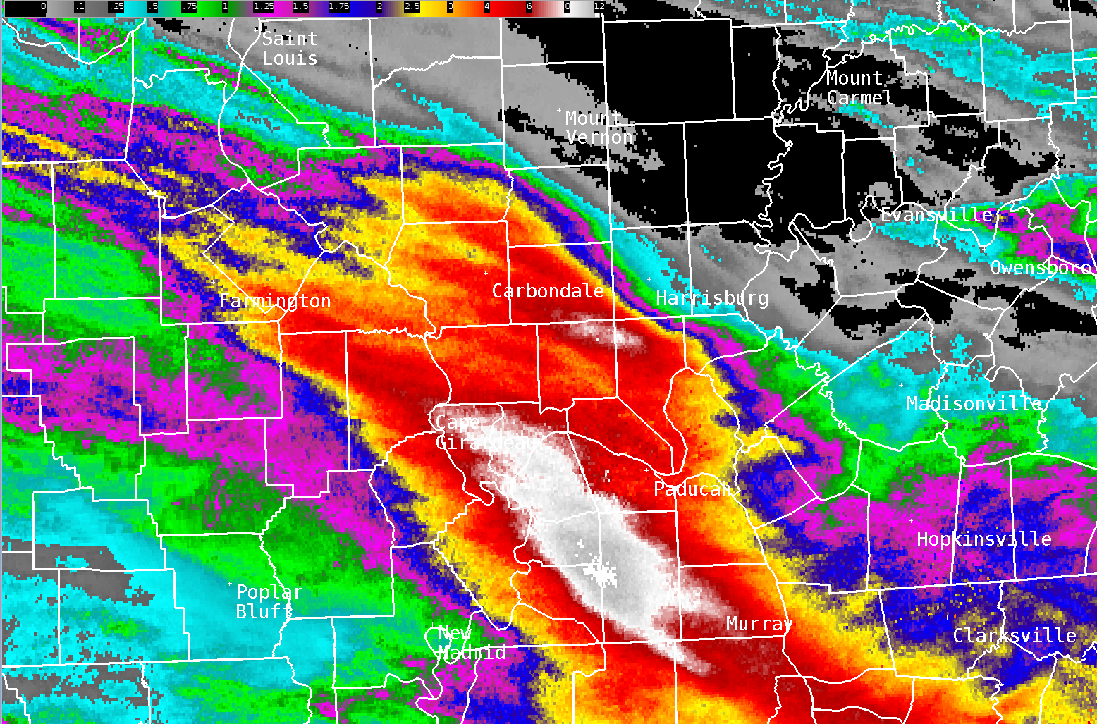
A corridor of 6 to 12 inches of rain occurred from Cape Girardeau and Carbondale southeast to Mayfield and Murray. The swath of 6+ inch amounts was roughly 25 miles wide and 90 miles long. The KY mesonet site 6 miles southwest of Mayfield received 11.28" of rain in a 24 hour period. This broke the previous Kentucky state record for 24 hour rainfall. The old record was 10.48" in Louisville, KY back on March 1, 1997. The highest observed amount that we received was 12.76" from a personal weather station near Fancy Farm, KY (Graves County). The map below shows MRMS radar estimates over a 24 hour period ending at 11 AM July 19th. The majority of this rain occurred after 10 PM on July 18th.
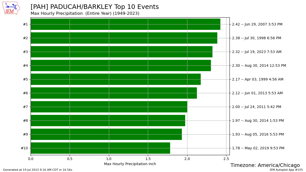
Paducah registered 2.32" of rain between 7 and 8 AM on July 19th. This was the 3rd largest 1 hour rainfall total on record, just shy of the all-time record of 2.42" established between 3 and 4 PM on June 29, 2007. Rainfall rates were generally 2 to 3 inches per hour across the hardest hit areas. However, some areas received 1 inch in as little as 10 to 15 minutes!
(Yellow and orange values on the map below signify amounts of 2.5 to 4", while reds were 4 to 7", and whites 7 to 13")
 |
 |
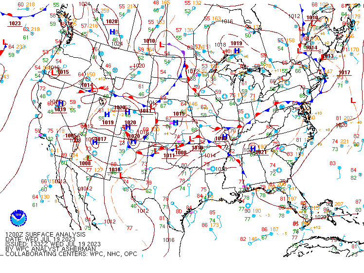
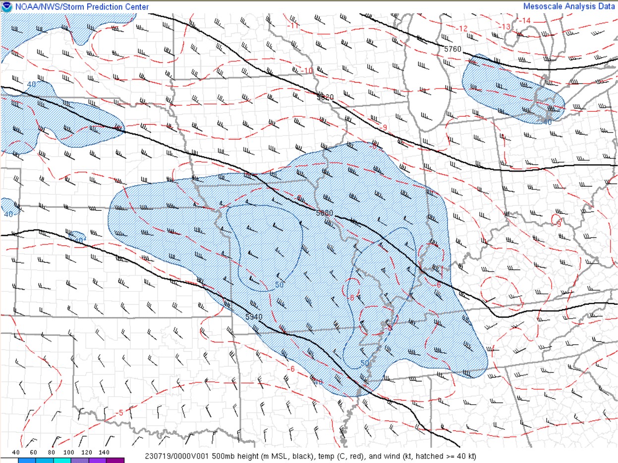
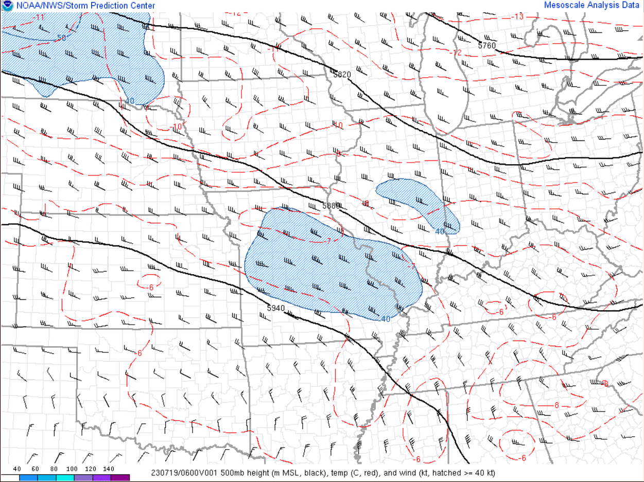
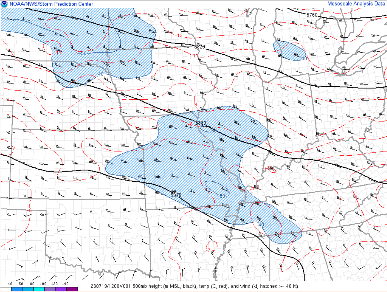
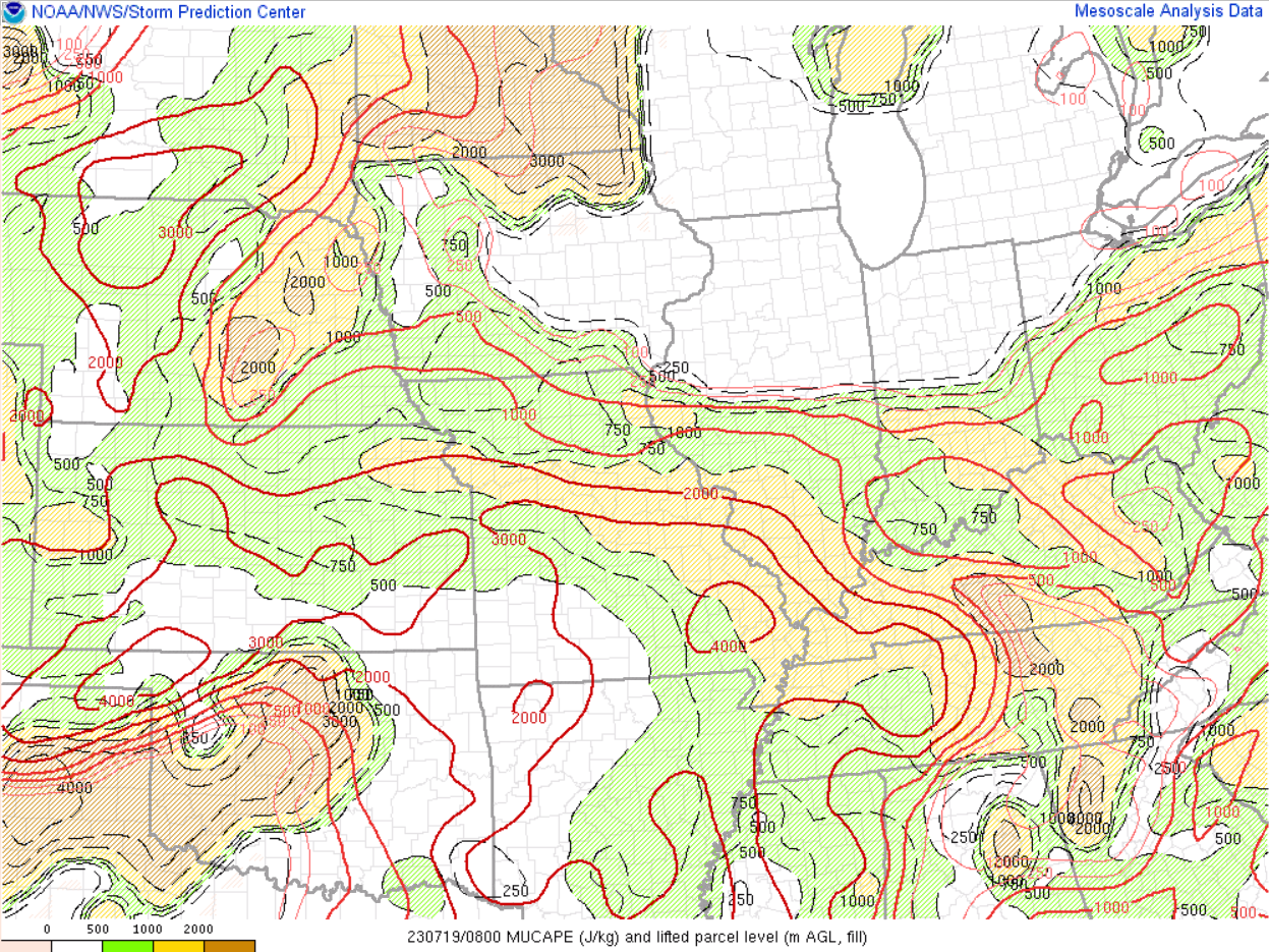
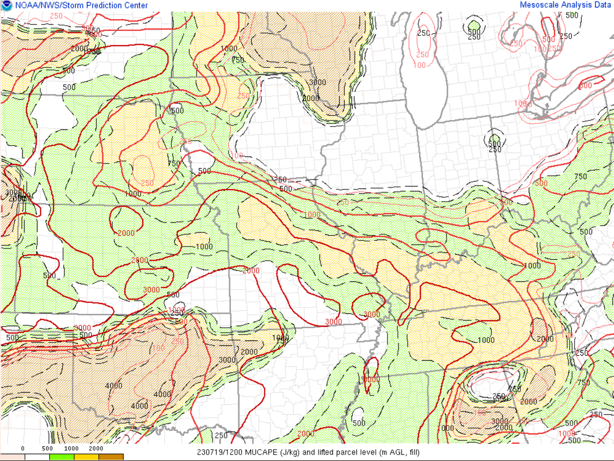
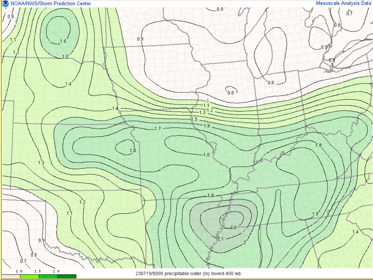
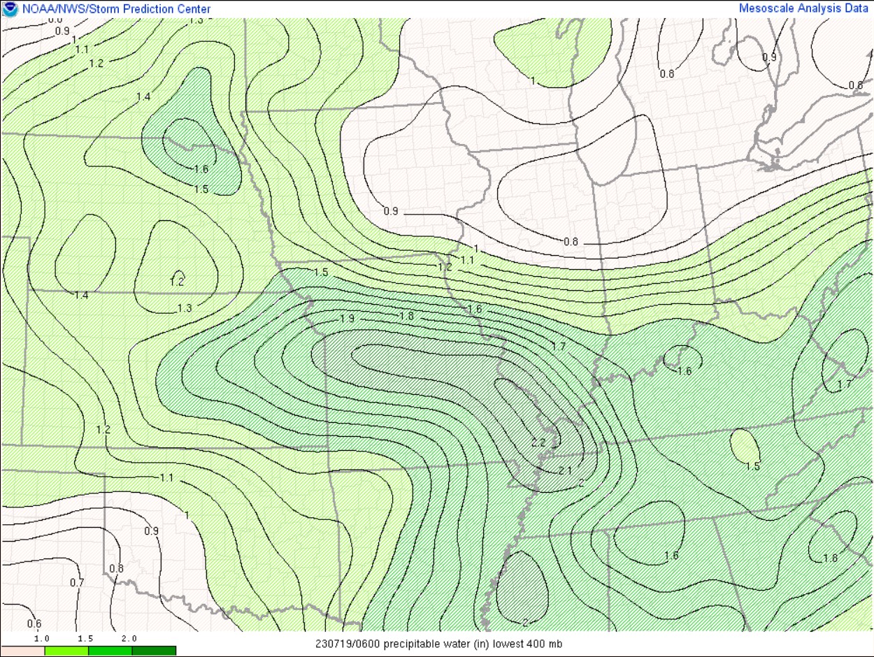
Environment
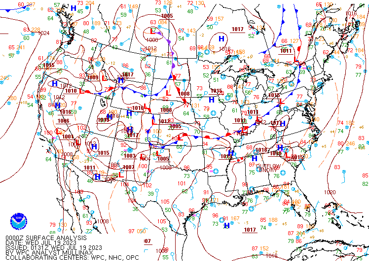
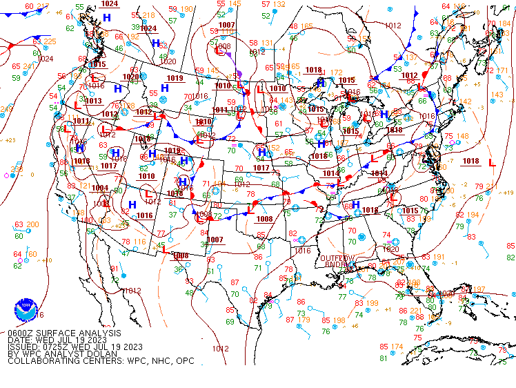
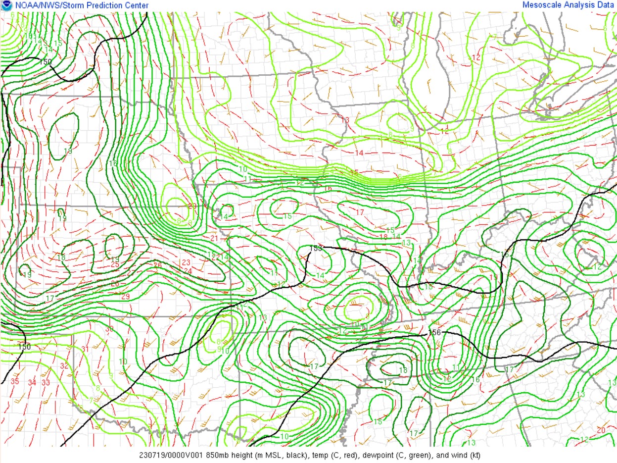
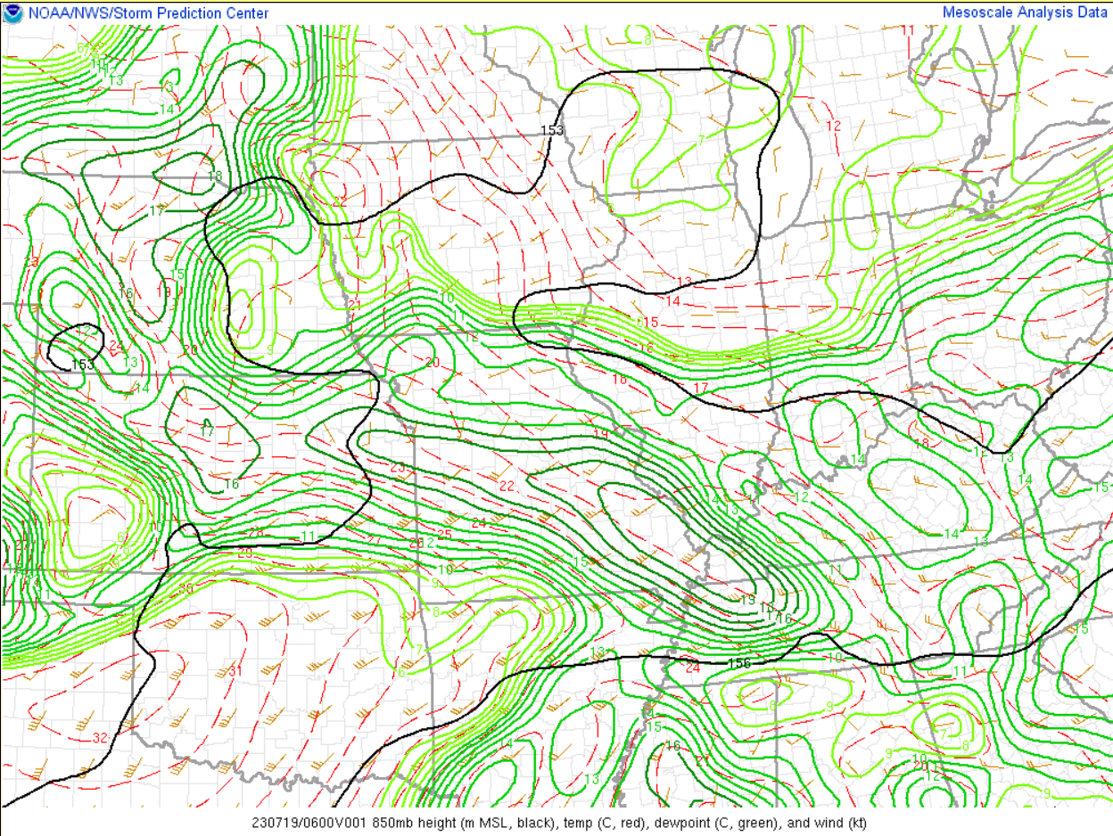
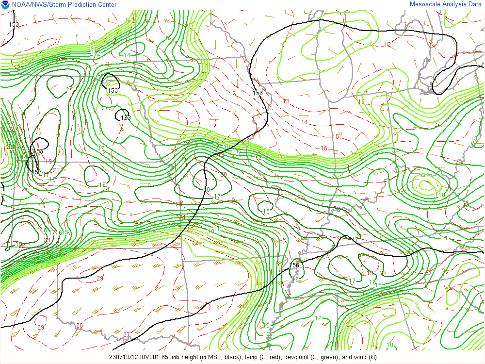
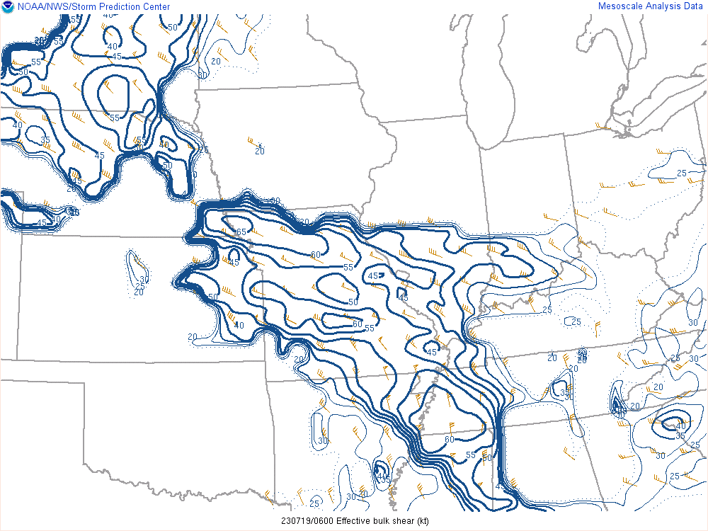
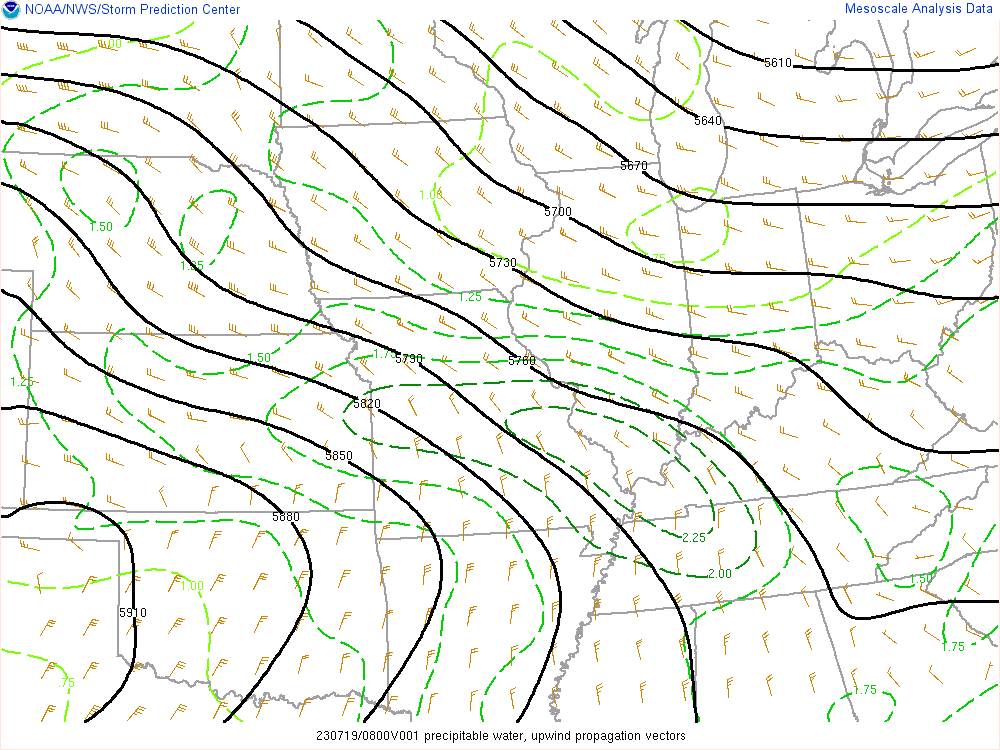
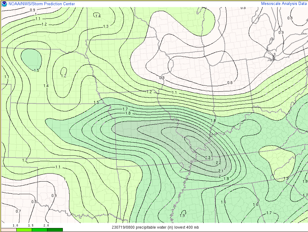
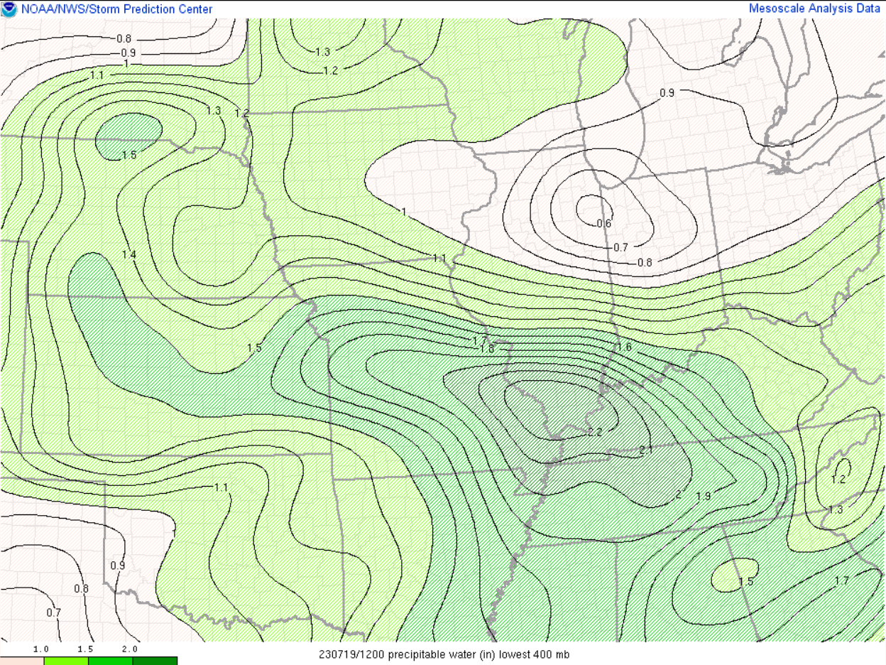
An MCS moved across the region during the late morning and afternoon on July 18th. Behind this system, a boundary setup southwest of us from south central Missouri into northeast Arkansas. This boundary lifted back northeast into southeast Missouri during the overnight and into the morning on July 19th. At the same time, a low level jet ramped up and led to strong convergence in the 850-700mb layer across the heart of our region. Extremely high moisture levels were present with precipitable water values up to 2.3". The position of the boundary oriented parallel with the flow provided an ideal setup for training convection over the same areas. The initial storms blew up by 11 PM and continued to channel southeastward across the same areas through the following morning.
 |
 |
 |
| WPC Surface Analysis at 7pm CDT July 18 | WPC Surface Analysis at 1am CDT July 19 | WPC Surface Analysis at 7am CDT July 19 |
 |
 |
 |
| RAP 500 mb analysis at 7pm CDT July 18 | RAP 500 mb analysis at 1am CDT July 19 | RAP 500 mb analysis at 7am CDT July 19 |
 |
 |
 |
| RAP 850 mb analysis at 7pm CDT July 18 | RAP 850 mb analysis at 1am CDT July 19 | RAP 850 mb analysis at 7am CDT July 19 |
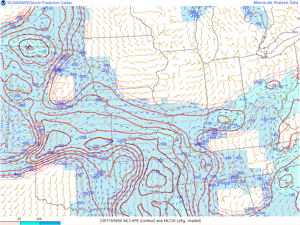
Near-storm environment summary.
 |
 |
 |
 |
| RAP MLCAPE analysis at 1am CDT July 19 | RAP effective bulk shear analysis at 1am CDT July 19 | RAP upwind propagation vector at 3am CDT July 19 | RAP 925-850 mb layer moisture transport at 3am CDT July 19 |
 |
 |
 |
 |
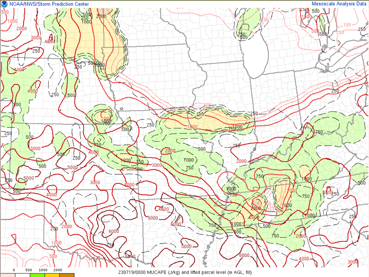
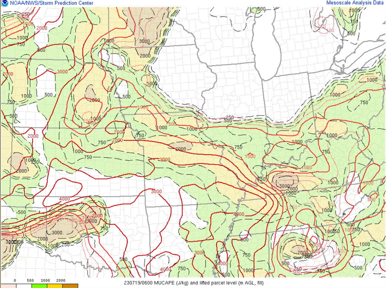
| SPC MUCAPE 7pm CDT July 18 | SPC MUCAPE 1am CDT July 19 | SPC MUCAPE 3am CDT July 19 | SPC MUCAPE 7am CDT July 19 |
 |
 |
 |
 |
| SPC PWAT 7pm CDT July 18 | SPC PWAT 1am CDT July 19 | SPC PWAT 3am CDT July 19 | SPC PWAT 7am CDT July 19 |
Additional environmental data.
 |
 |
 |
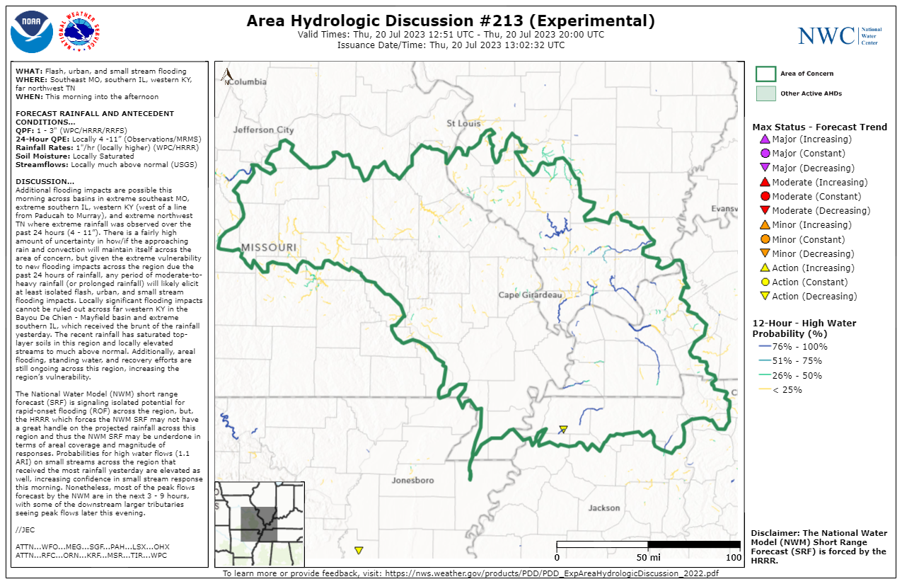 |
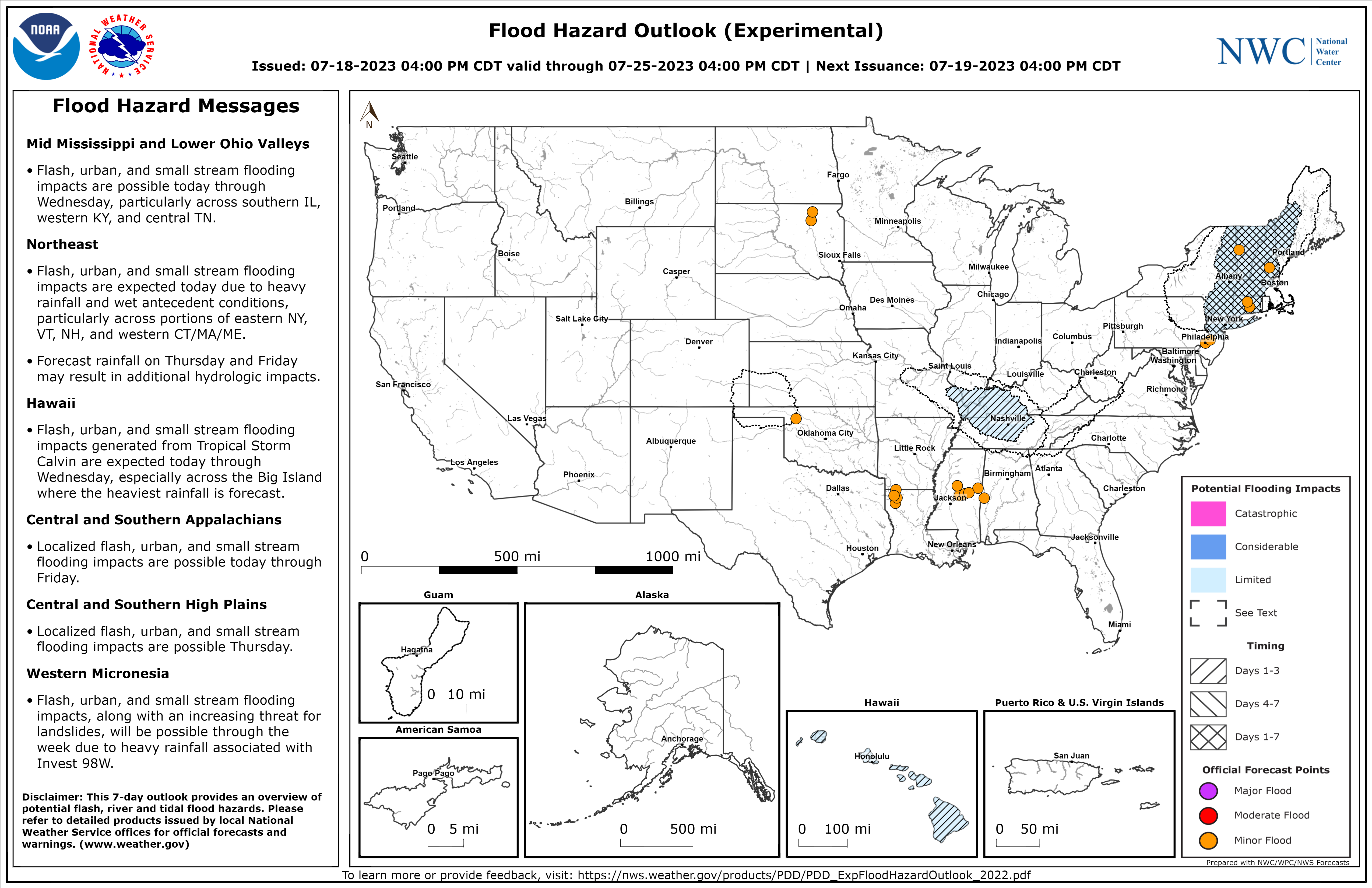
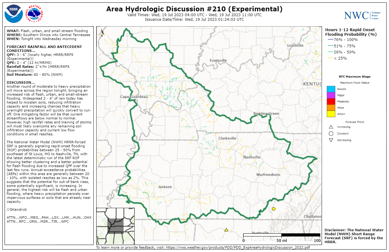
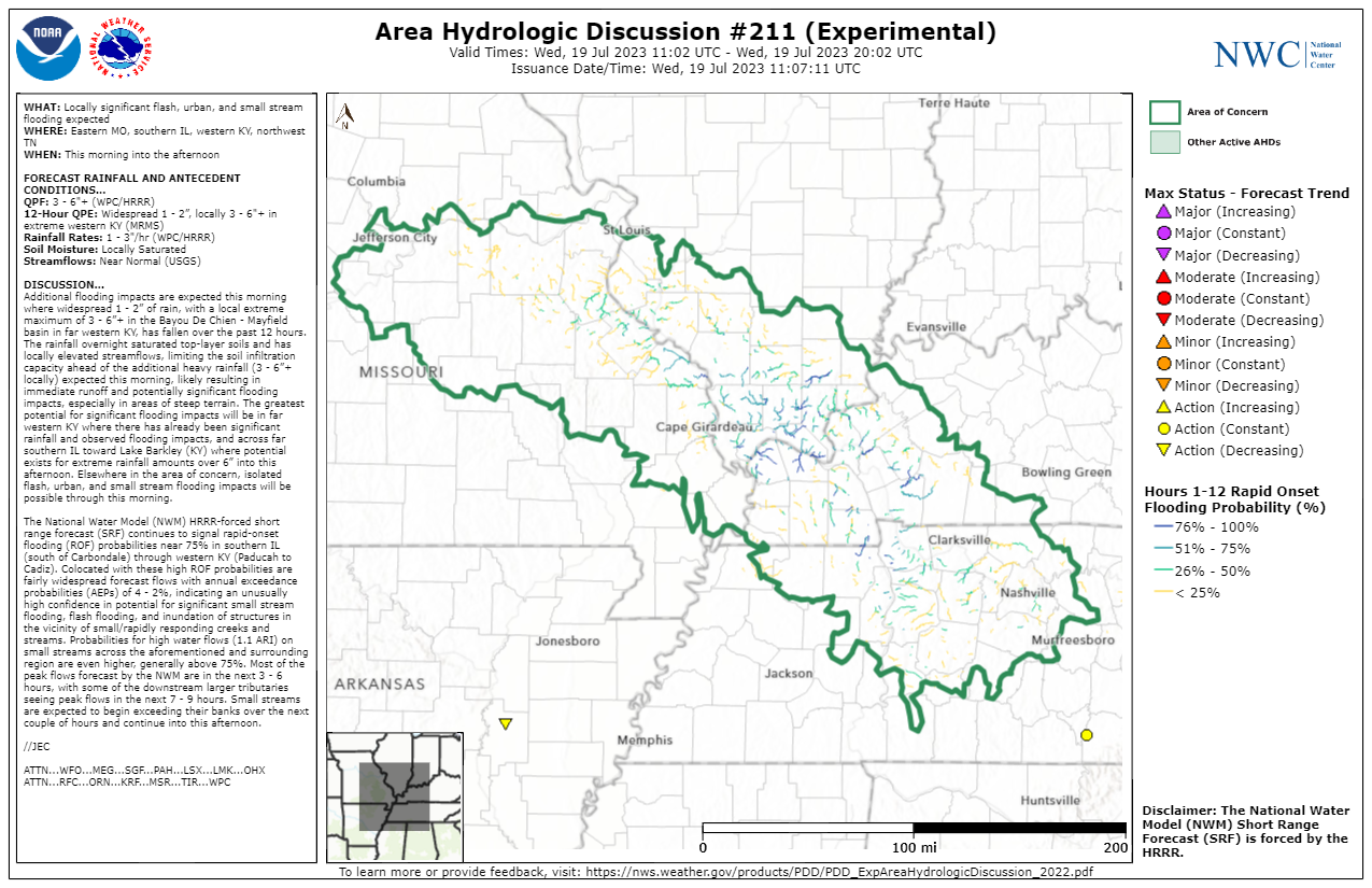
| NWC Flood Hazard Outlook 4pm CDT July 18 | NWC Area Hydrologic Discussion #210 8:24pm CDT July 18 | NWC Area Hydrologic Discussion #211 6:07am CDT July 19 | NWC Area Hydrologic Discussion #213 8:02am CDT July 20 |
 |
 |
 |
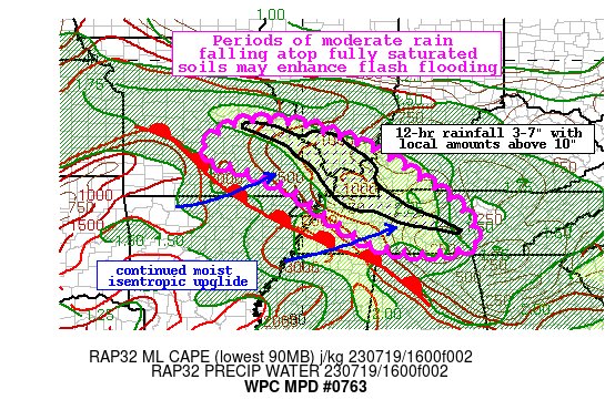 |
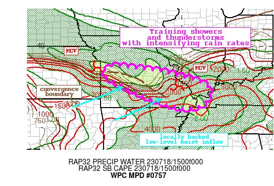
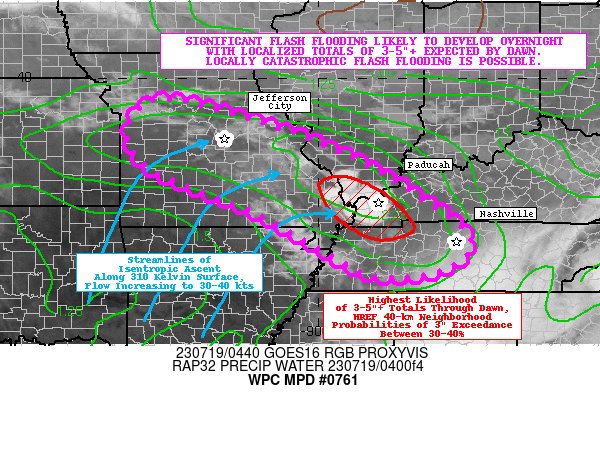
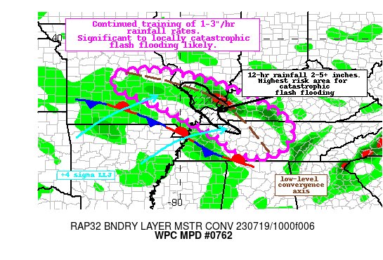
| WPC Mesoscale Precipitation Discussion #757 12:14pm CDT July 18 | WPC Mesoscale Precipitation Discussion #761 12:15am CDT July 19 | WPC Mesoscale Precipitation Discussion #762 7:04am CDT July 19 | WPC Mesoscale Precipitation Discussion #763 12:46pm CDT July 19 |
Additional Information
The Forecast
 |
 |
 |
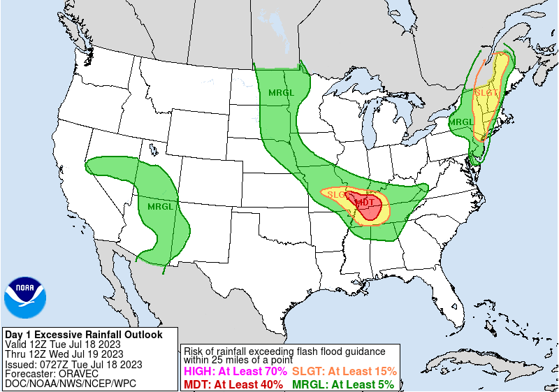 |
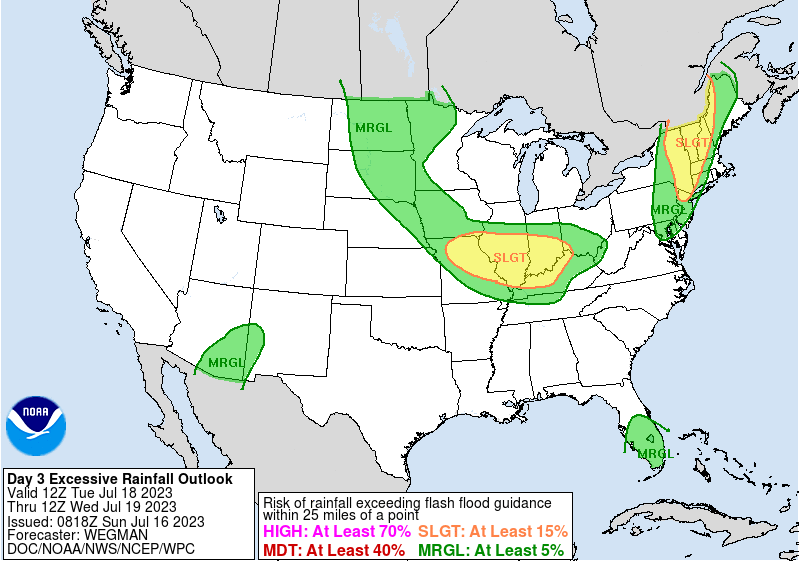
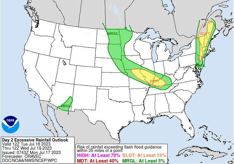
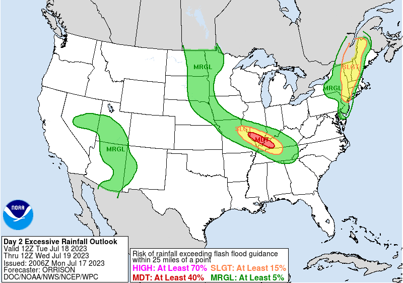
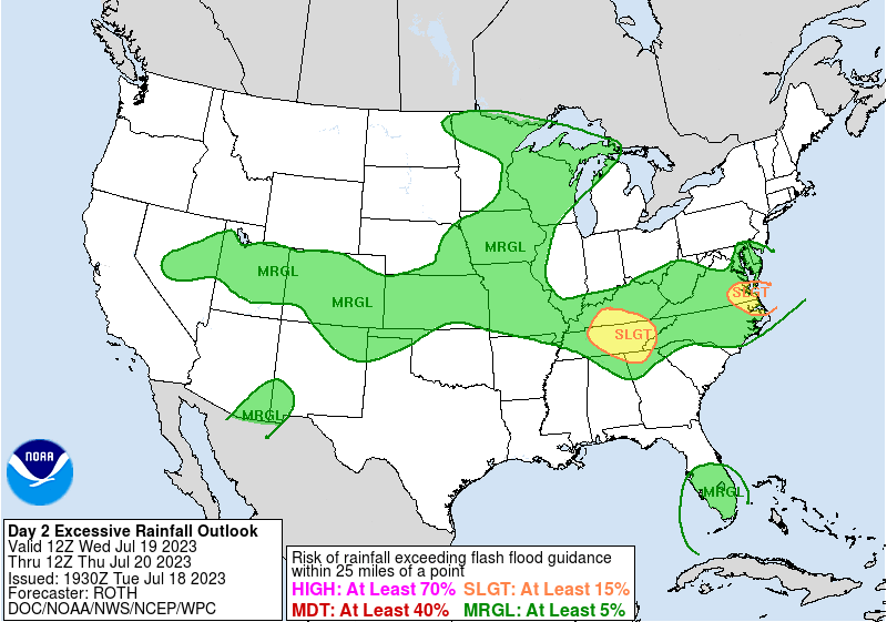
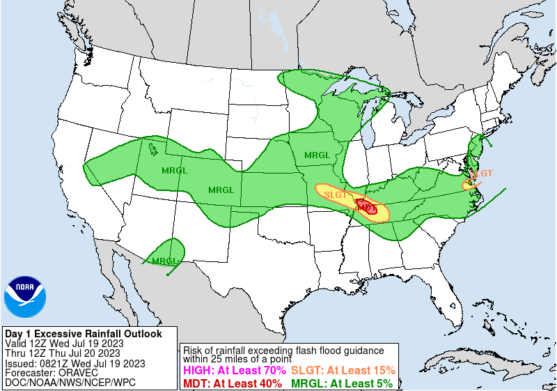
| WPC Tue-Wed Day 3 Excessive Rainfall Outlook | WPC Tue-Wed Day 2 Excessive Rainfall Outlook | WPC Tue-Wed Day 2 Excessive Rainfall Outlook PM Update | WPC Tue-Wed Day 1 Excessive Rainfall Outlook |
 |
 |
 |
 |
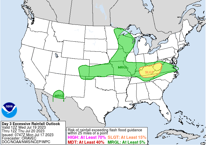
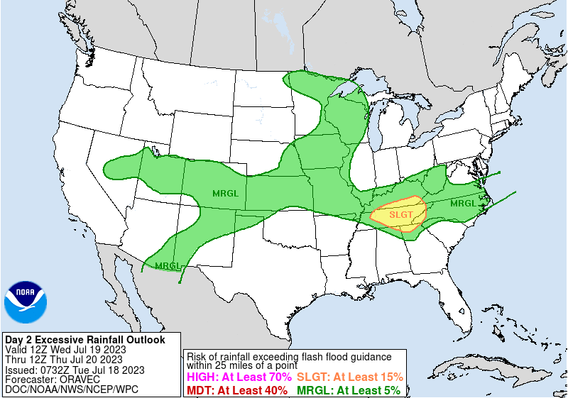
| WPC Wed-Thu Day 3 Excessive Rainfall Outlook | WPC Wed-Thu Day 2 Excessive Rainfall Outlook | WPC Wed-Thu Day 2 Excessive Rainfall Outlook PM Update | WPC Wed-Thu Day 1 Excessive Rainfall Outlook |
Flash Flood Emergencies
| Counties | Issuance Time |
| SE Carlisle (KY), SW Graves (KY), NE Hickman (KY) | 2:52 AM July 19, 2023 |
| S Ballard (KY), E Carlisle (KY), C Graves (KY) | 5:41 AM July 19, 2023 |
| S Ballard (KY), Carlisle (KY), C Graves (KY), NE Hickman (KY) | 7:54 AM July 19, 2023 |
| McCracken (KY) | 8:25 AM July 19, 2023 |
| Pulaski (IL), C Ballard (KY) | 9:09 AM July 19, 2023 |
 |
Media use of NWS Web News Stories is encouraged! Please acknowledge the NWS as the source of any news information accessed from this site. |
|

