Overview
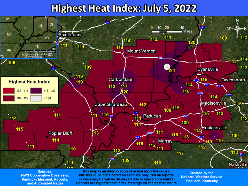
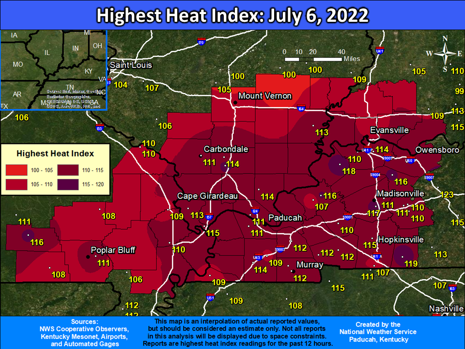
A strong upper level ridge of high pressure built into the lower Ohio Valley on the 4th of July and remained in place until a cold front provided relief from the heat late on July 8th. The most oppressive days were July 5 and 6. High temperatures in the mid 90s to around 100 combined with extremely high dewpoints ranging from 75 to 80 to produce heat index readings above 110 in most locations, and localized readings up to around 120 were observed. Some areas saw relief from the heat on July 7th, especially portions of southern Illinois and southwest Indiana. Additional relief in the form of scattered showers and thunderstorms occurred on the 8th. Paducah's heat index of 114 on July 5 was their highest heat index since August 3, 2011. Paducah also managed to reach a peak heat index of 110 on 4 straight days from July 5-8. This was the first time Paducah observed 4 straight days exceeding a 110 degree heat index since July 31 - August 3, 1987. Triple digit temperatures were also experienced for some areas. In Evansville, this was the first time since 2012 that high temperatures reached 100 degrees. For Paducah, it was the first time since 2016 reaching 100.
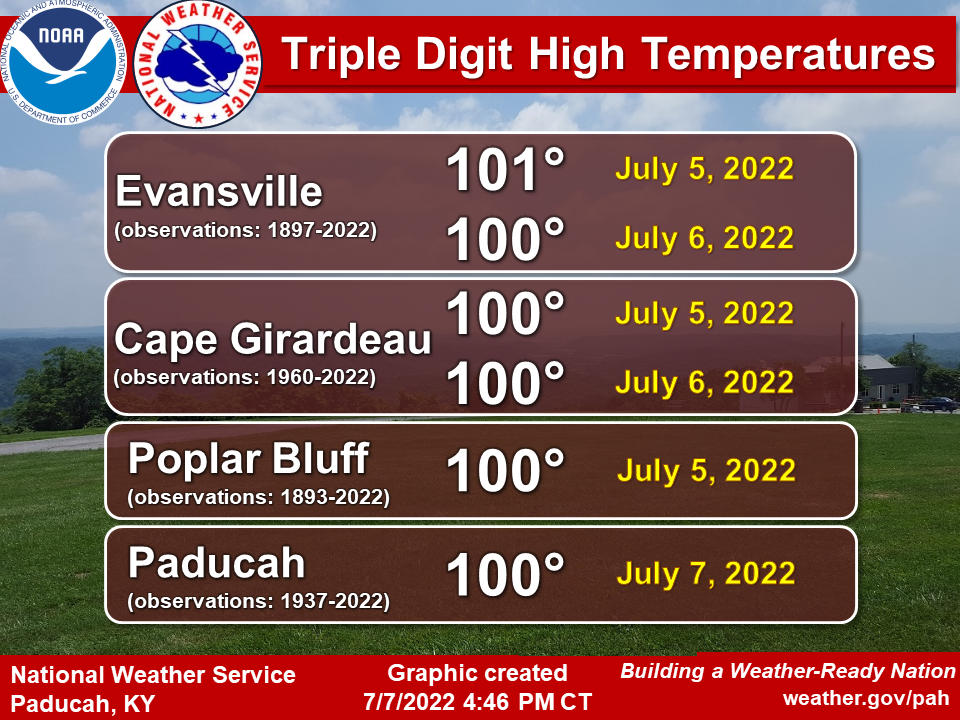
Records and Triple Digit Temperatures:
Record warm lows were established at all 5 climate sites on July 6th with lows remaining in the upper 70s to around 80 degrees. No record highs were set during this heat wave. However, several locations reached 100 degrees. In Evansville, it was the first time since 2012 that temperatures soared above 100. They also achieved a rare feat on July 6 when the high hit 100 and the low only fell to 80 degrees. The last time they observed a high over 100 and low remaining above 80 on the same day was way back on June 26, 1978. In Paducah we hit 100 degrees for the first time since June 2016.
 |
.PNG) |
Heat Index Graphics and Table:
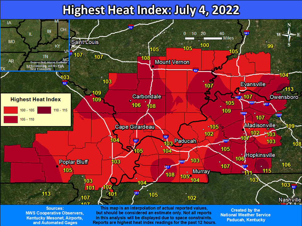
Observed Heat Index Readings Monday July 4th through Friday July 8th, 2022 (Click images to enlarge)
 |
 |
 |
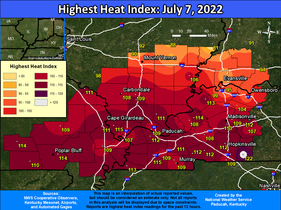 |
The table below shows the maximum daily heat index readings observed at all airport locations (ASOS/AWOS) and Kentucky Mesonet stations across our 58 county forecast area. These are the most reliable and accurate stations across the region. The bottom row of the chart gives the highest daily heat index reading observed across the area from these 32 stations. The heat index is calculated from a combination of air temperatures and dewpoint temperatures or relative humidity.
Maximum Daily Heat Index Readings:
| Location | Station Type | July 4 | July 5 | July 6 | July 7 | July 8 |
| Cape Girardeau MO | ASOS | 104 | 111 | 109 | 111 | 109 |
| Carbondale IL | ASOS | 106 | 113 | 111 | 108 | 106 |
| Evansville IN | ASOS | 101 | 109 | 107 | 90 | 102 |
| Paducah KY | ASOS | 104 | 114 | 111 | 112 | 110 |
| Poplar Bluff MO | ASOS | 105 | 114 | 111 | 114 | 111 |
| Cairo IL | AWOS | 105 | 115 | 107 | 106 | |
| Carmi IL | AWOS | 107 | 121 | 113 | 106 | 108 |
| Fairfield IL | AWOS | 100 | 111 | 102 | 89 | 101 |
| Fort Campbell KY | AWOS | 111 | 109 | 107 | 109 | 109 |
| Greenville KY | AWOS | 103 | 109 | 110 | 112 | 110 |
| Henderson KY | AWOS | 105 | 114 | 110 | 99 | 108 |
| Madisonville KY | AWOS | 102 | 110 | 111 | 109 | 110 |
| Marion IL | AWOS | 108 | 117 | 114 | 109 | 108 |
| Marion KY | AWOS | 102 | 109 | 107 | 108 | 106 |
| Mayfield KY | AWOS | 109 | 109 | 109 | 109 | |
| Metropolis IL | AWOS | 103 | 111 | 111 | 109 | 111 |
| Murray KY | AWOS | 105 | 112 | 112 | 109 | 111 |
| Owensboro KY | AWOS | 105 | 109 | 111 | 96 | 108 |
| Perryville MO | AWOS | 109 | 119 | 110 | 111 | 110 |
| Sikeston MO | AWOS | 103 | 113 | 110 | 109 | 113 |
| Benton KY 4 N | KYMN | 103 | 111 | 112 | 111 | 112 |
| Cadiz KY 4 SW | KYMN | 107 | 113 | 112 | 112 | 113 |
| Calhoun KY 5 NW | KYMN | 107 | 114 | 116 | 104 | 109 |
| Elkton KY 5 SW | KYMN | 115 | 119 | 119 | 122 | 118 |
| Greenville KY 6 N | KYMN | 105 | 113 | 114 | 115 | 115 |
| Henderson KY 5 E | KYMN | 107 | 115 | 114 | 95 | 106 |
| Hickman KY 2 E | KYMN | 104 | 112 | 109 | 113 | 112 |
| Hopkinsville KY 6 N | KYMN | 106 | 114 | 115 | 112 | 115 |
| Madisonville KY 4 S | KYMN | 107 | 115 | 117 | 113 | 115 |
| Marion KY 4 NE | KYMN | 105 | 115 | 116 | 114 | 109 |
| Mayfield KY 6 SW | KYMN | 108 | 116 | 114 | 115 | 115 |
| Morganfield KY 4 E | KYMN | 109 | 118 | 118 | 113 | 109 |
| Murray KY 1 W | KYMN | 104 | 111 | 112 | 109 | 114 |
| Princeton KY 2 SE | KYMN | 105 | 109 | 110 | 108 | 111 |
| Daily Maximum: | 115 | 121 | 119 | 122 | 118 |
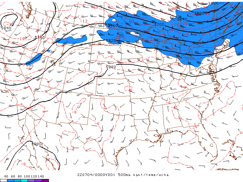
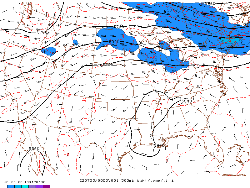
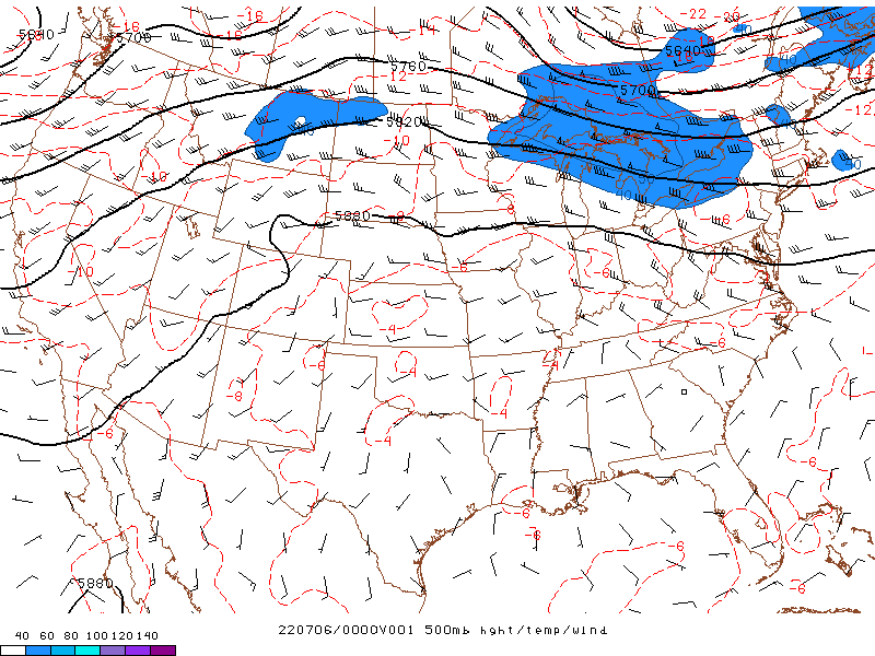
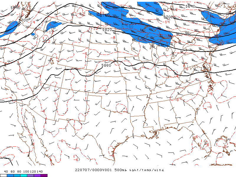
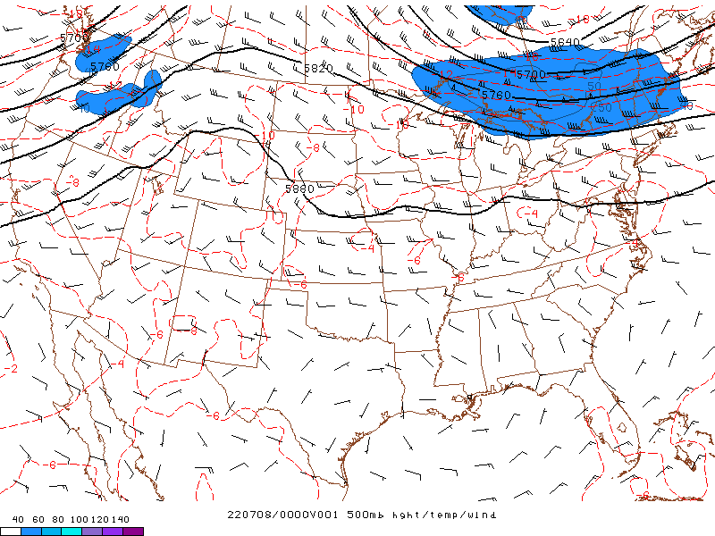
Upper Level Pattern
The graphics below show observed 500 mb heights, wind, and temperature. This shows the overall weather pattern approximately 20,000 feet above the surface. The higher heights are indicative of upper level ridging which developed across the southern U.S. from July 4 through 8. Eventually the ridge gets squashed further south and west of our area as a cold front makes passage late on July 8th into early July 9th.
 |
 |
| Valid 7 PM July 3, 2022 | Valid 7 PM July 4, 2022 |
 |
 |
| Valid 7 PM July 5, 2022 | Valid 7 PM July 6, 2022 |
 |
|
| Valid 7 PM July 7, 2022 |
 |
Media use of NWS Web News Stories is encouraged! Please acknowledge the NWS as the source of any news information accessed from this site. |
|

