Overview
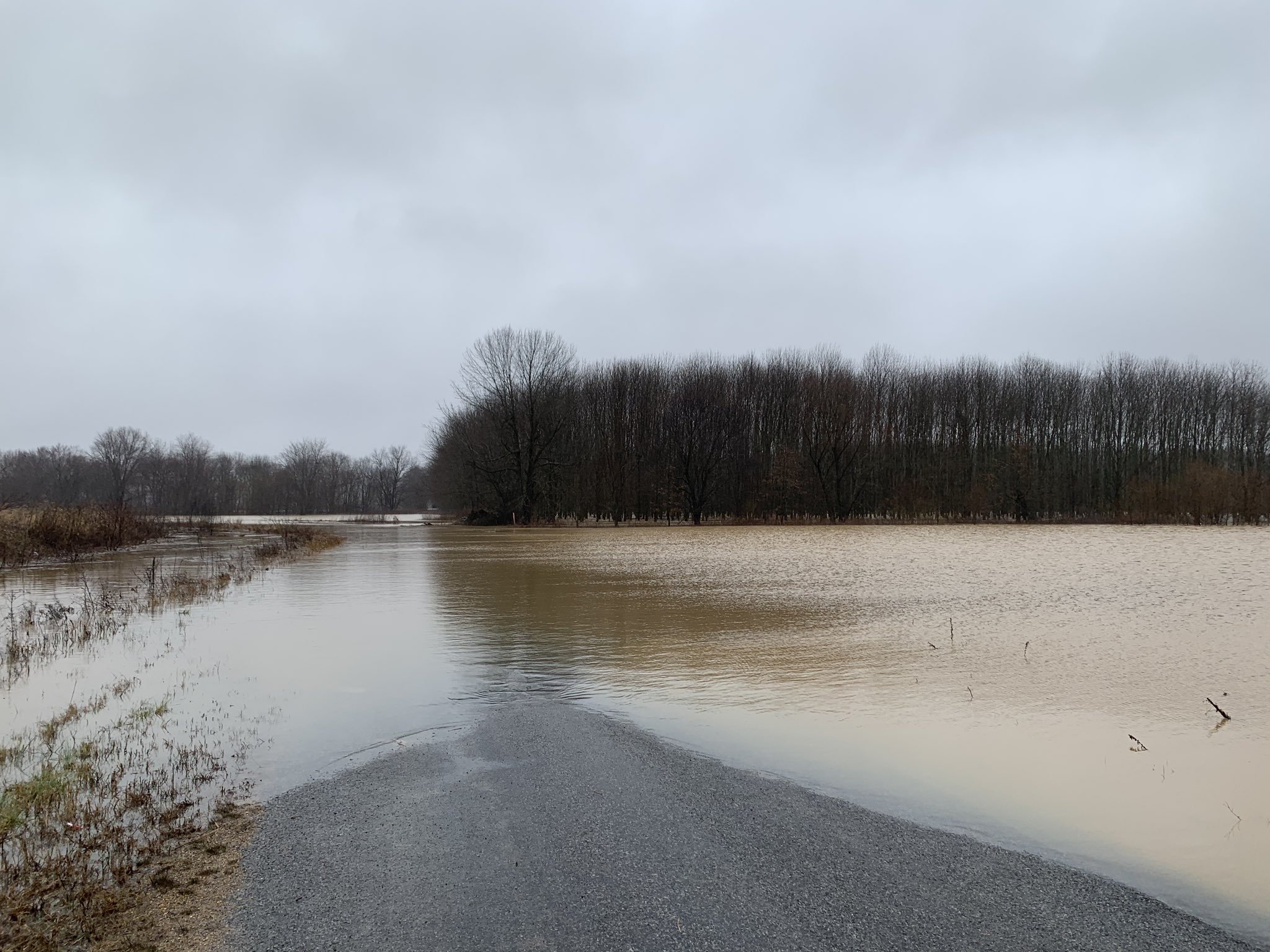
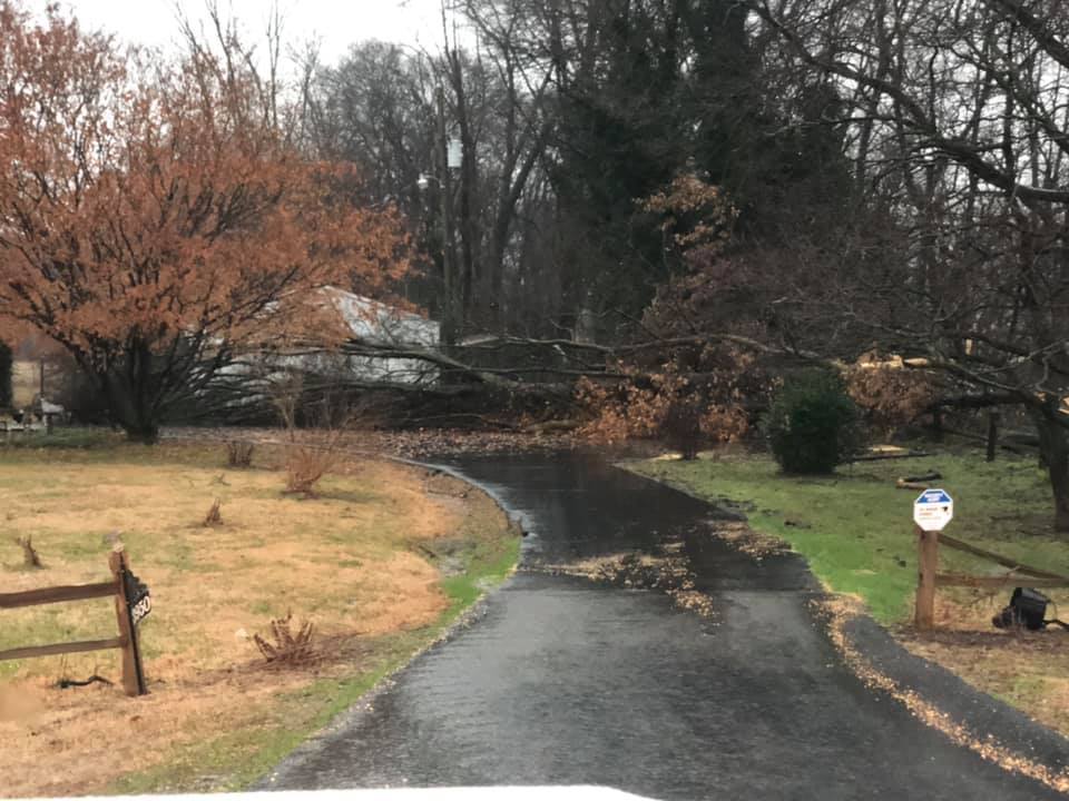
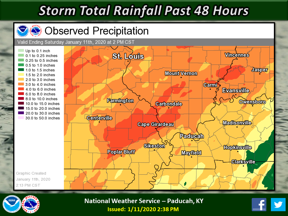
An unseasonably strong storm system by January standards impacted the region January 10-11, 2020. Heavy rainfall, flooding, damaging winds, tornadoes, and gusty non-thunderstorm winds impacted the region during this time. The bulk of the event occurred overnight and into the morning hours on the 11th. Rainfall totals ranged from 2 to 5 inches, which resulted in widespread areal flooding and flash flooding across the region. Damage surveys revealed 12 tornadoes occurred, with the majority occurring in western Kentucky. Most were rated EF-1, but there was one EF-2 that touched down in the Jackson, MO area.
|
|
||||||||||
|
||||||||||
|
Tornado #1 - NW of Pembroke, KY
Track Map 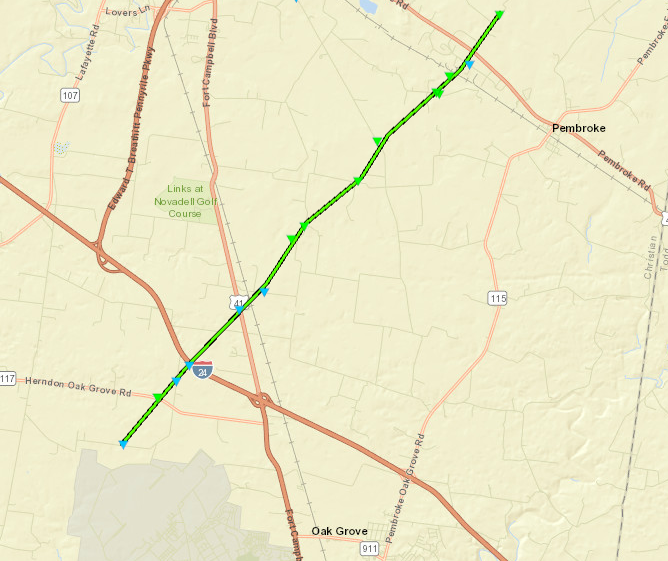 
|
||||||||||||||||
|
Tornado #2 - SE of Hopkinsville, KY
Track Map 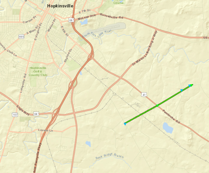
|
||||||||||||||||
|
Tornado #3 - Southern LBL, KY
Track Map 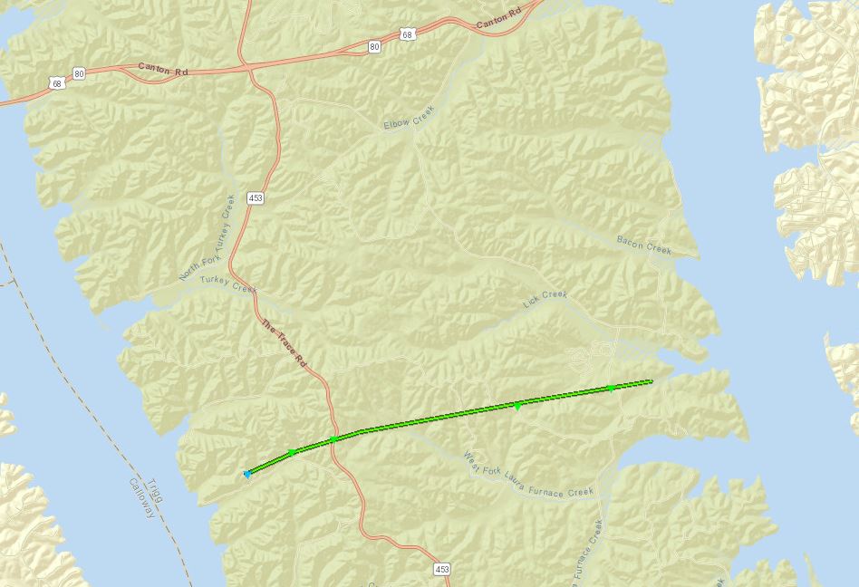
|
||||||||||||||||
|
Tornado #4 - Blue Spring, KY
Track Map 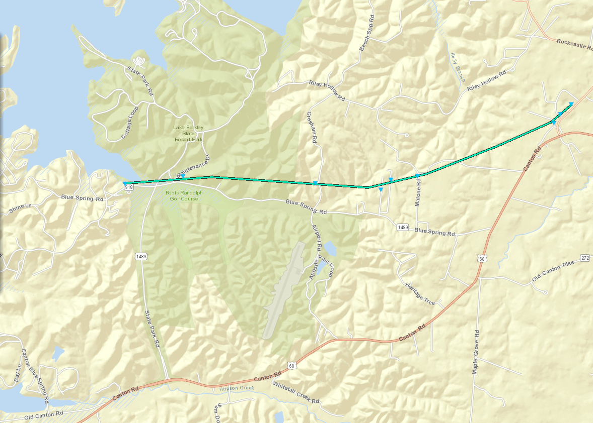
|
||||||||||||||||
|
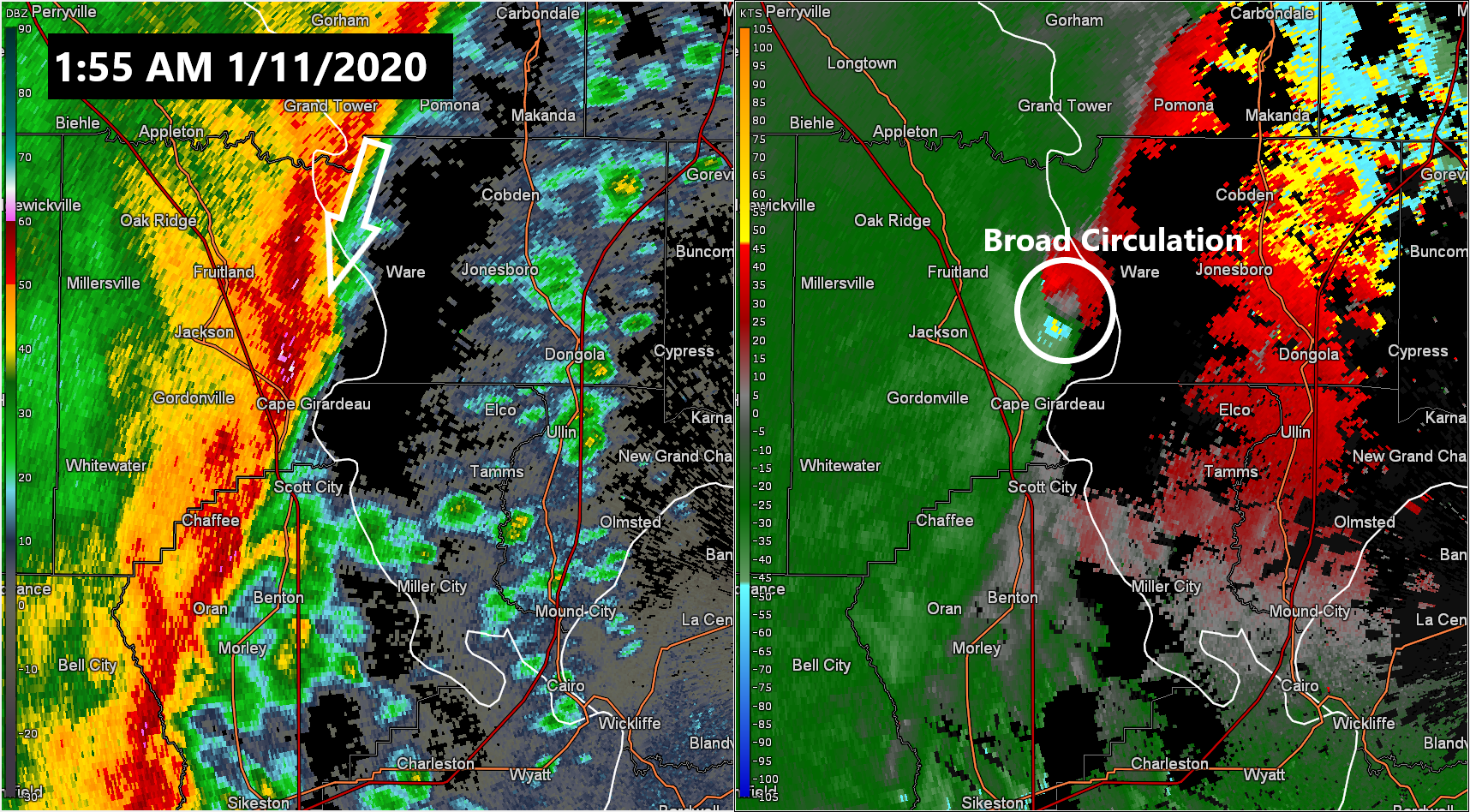
Tornado #5 - Jackson, MO
Track Map 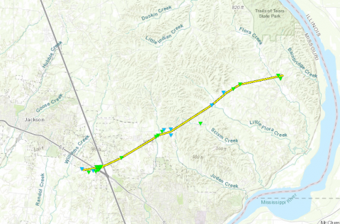 |
||||||||||||||||
|
Tornado #6 - Ware, IL
Track Map 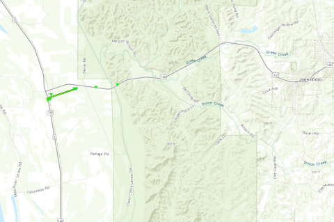 |
||||||||||||||||
|
Tornado #7 - Wingo, KY
Track Map 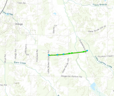 |
||||||||||||||||
|
Tornado #8 - Patton, MO
Track Map 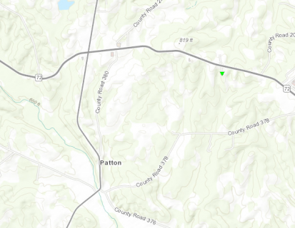 |
||||||||||||||||
|
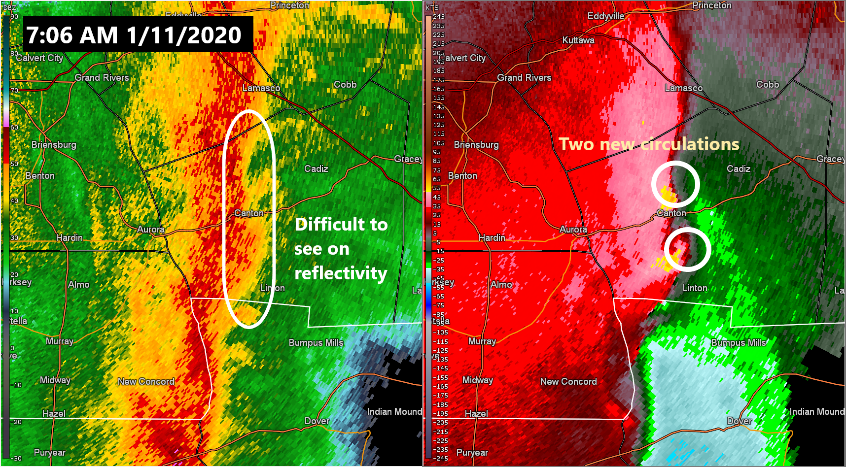
Tornado #9 - Southern Caldwell Co. into far northwest Christian Co., KY
Track Map 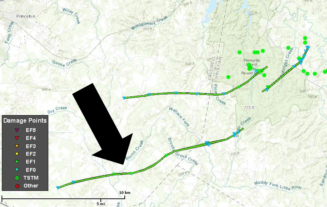 |
||||||||||||||||
|
Tornado #10 - Southern Caldwell Co. into northwest Christian Co. and Pennyrile Forest State Resort Park, KY
Track Map 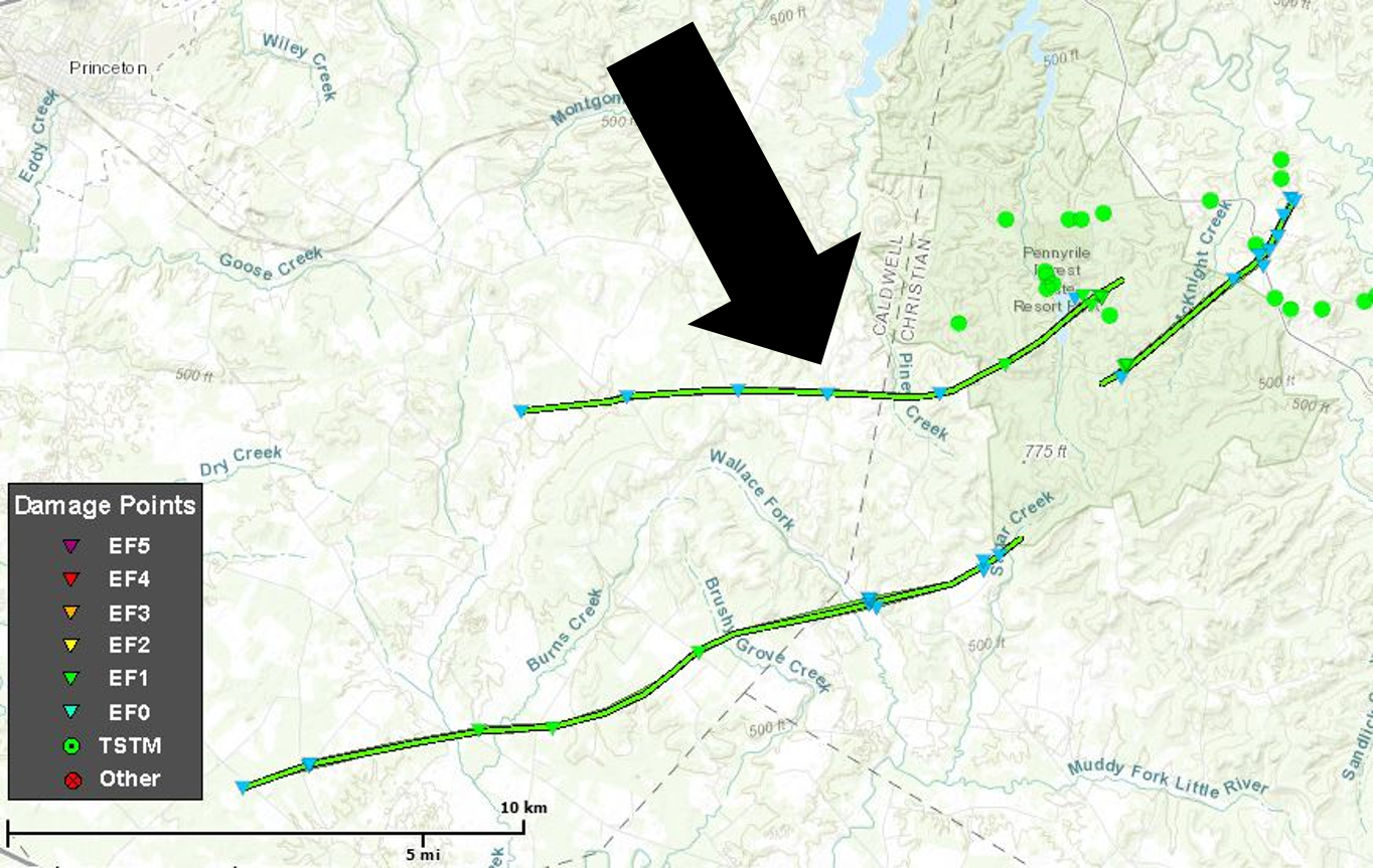 |
||||||||||||||||
|
Tornado #11 - Pennyrile Forest State Resort Park, KY
Track Map 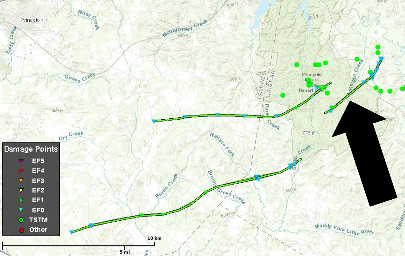 |
||||||||||||||||
|
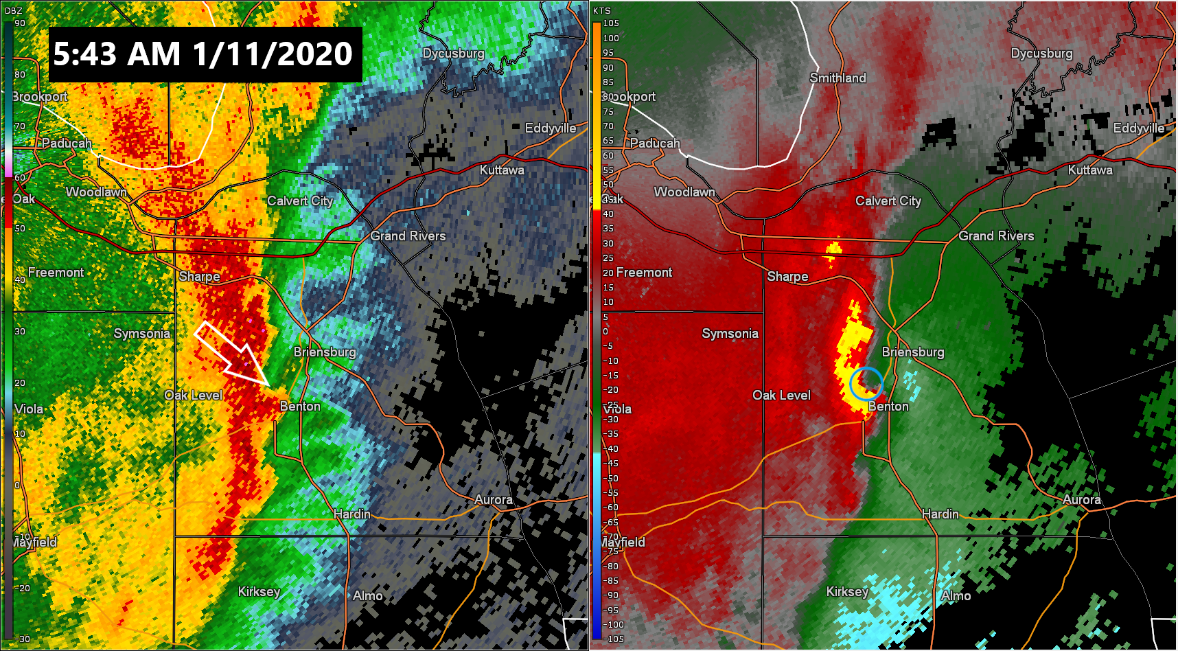
Tornado #12 - Benton, KY
Track Map 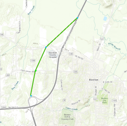 |
||||||||||||||||
The Enhanced Fujita (EF) Scale classifies tornadoes into the following categories:
| EF0 Weak 65-85 mph |
EF1 Moderate 86-110 mph |
EF2 Significant 111-135 mph |
EF3 Severe 136-165 mph |
EF4 Extreme 166-200 mph |
EF5 Catastrophic 200+ mph |
 |
|||||
Flooding
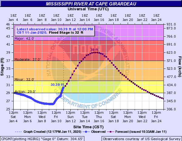
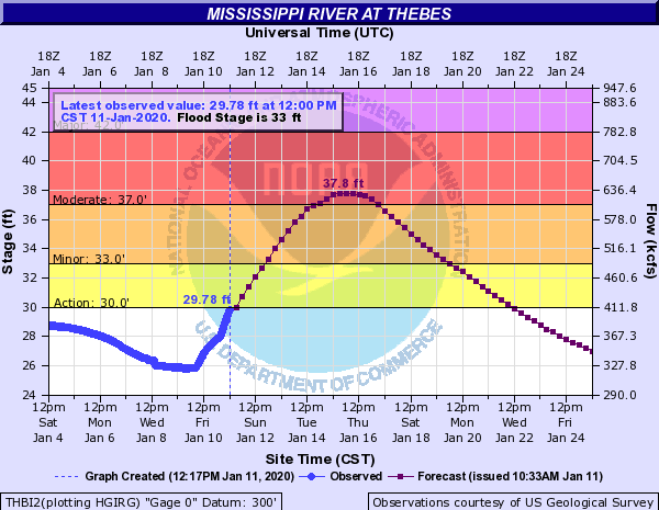
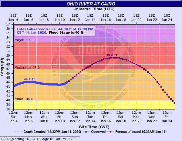
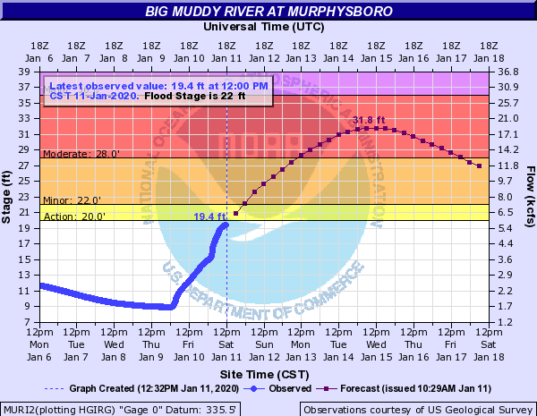
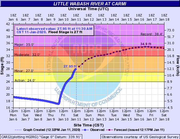
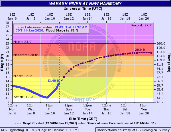
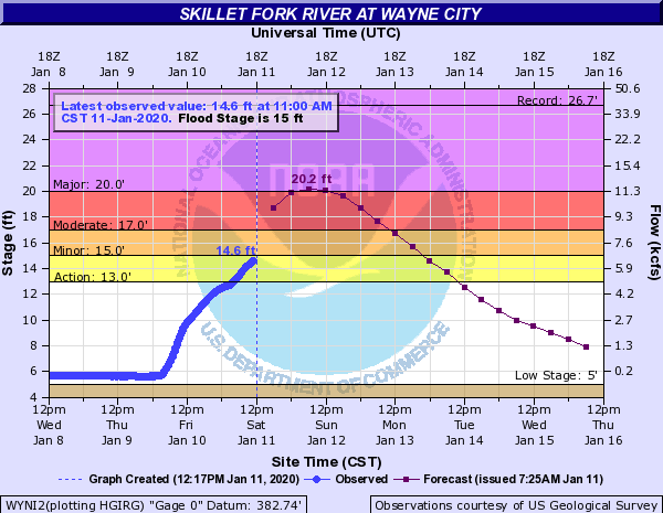
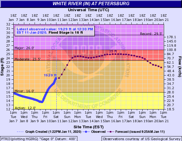
Due to the heavy rainfall, river levels are rising across the area. Numerous points are forecast to go into moderate flooding.
Hydrographs
 |
 |
 |
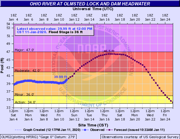 |
| Mississippi River at Cape Girardeau | Mississippi River at Thebes | Ohio River at Cairo | Ohio River at Olmsted |
 |
 |
 |
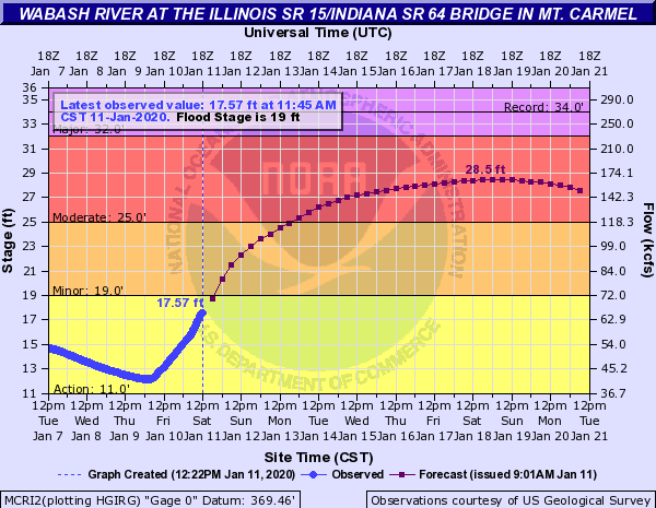 |
| Big Muddy River at Murphysboro | Little Wabash River at Carmi | Wabash River at New Harmony | Wabash River at Mount Carmel |
 |
 |
 |
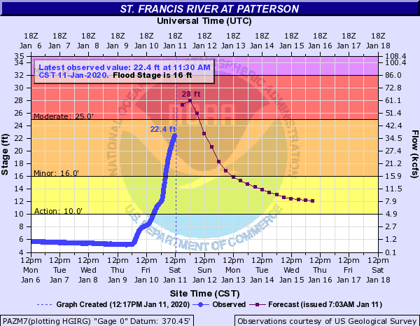 |
| Patoka River at Princeton, IN | Skillet Fork River at Wayne City, IL | White River at Petersburg | St. Francis River at Patterson |
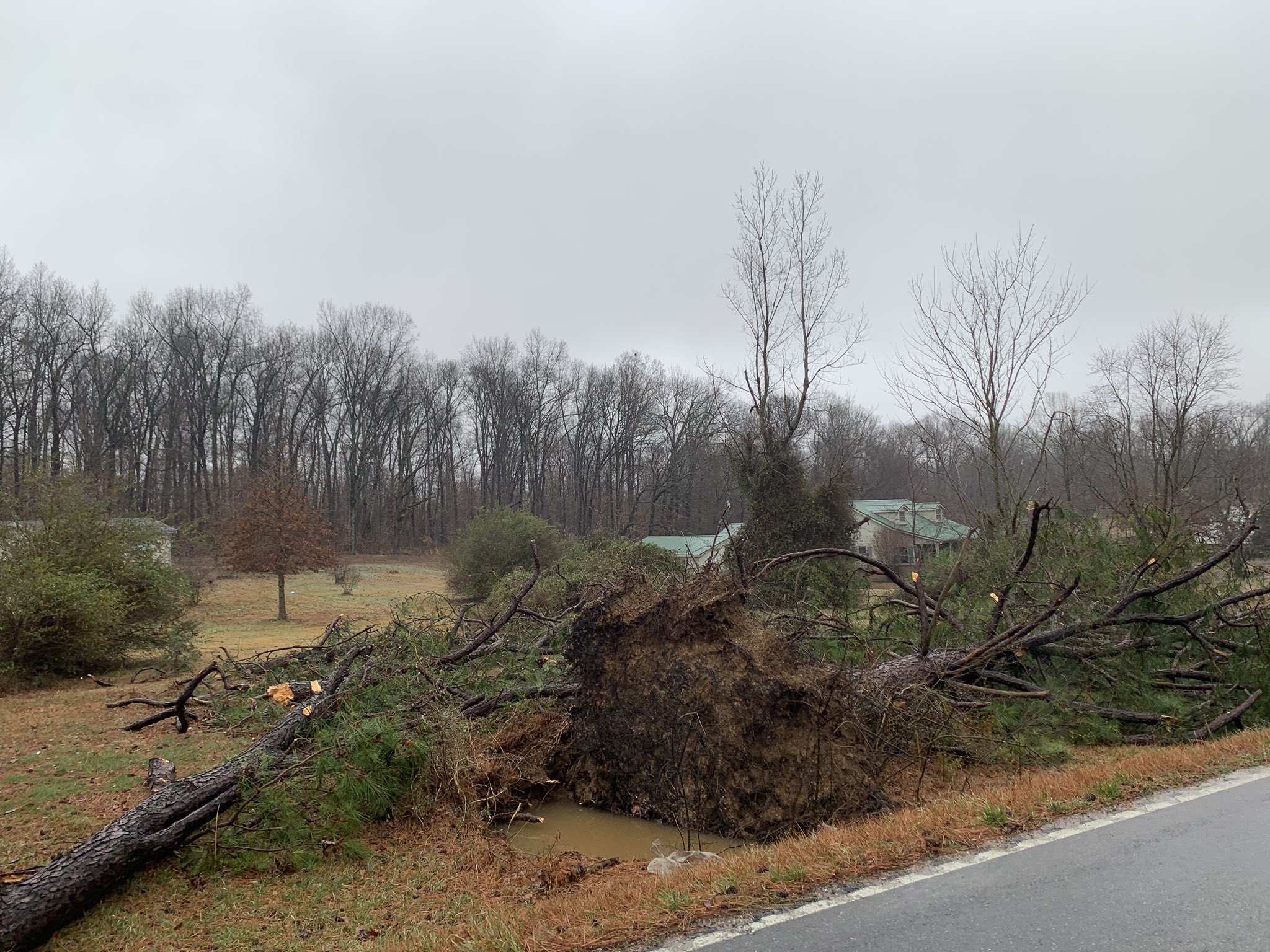
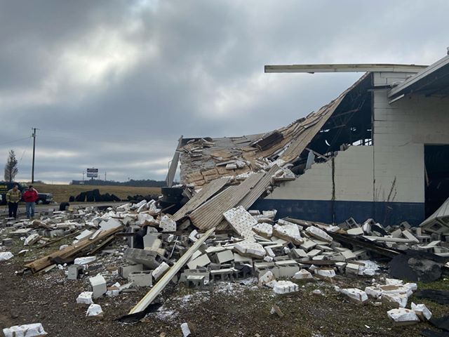
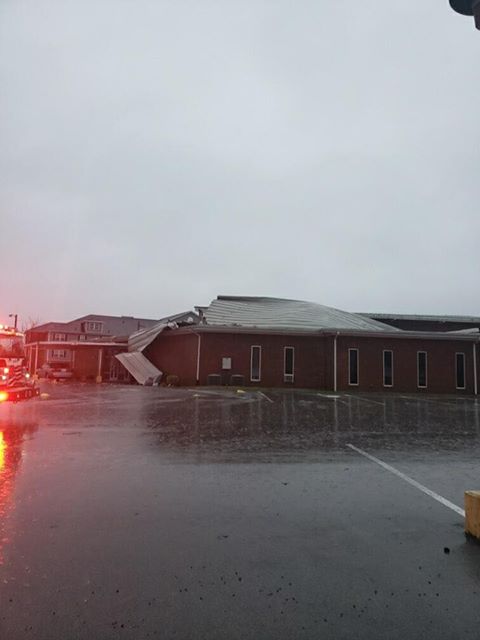
Photos
 |
 |
 |
 |
| Tree damage near Benton, KY via Jacob Woods | Clarks River out of banks in Graves County via Jacob Woods | Damage near Patton, MO via Calvin Troxell | Tree damage in Hopkinsville, KY via Elijah Kirby |
 |
 |
 |
.jpg) |
| Tornado damage in Jackson, MO via NWS Survey | Tornado damage in Jackson, MO via NWS Survey | Damage to senior center in Hopkinsville via Dave Powell. | Tornado damage in Ware, IL, via NWS Survey |
 |
 |
||
| Overturned semi truck in Hopkinsville, KY, via Brandon Henderson. | Overturned rail cars at the Carly Lane rail yard in Hopkinsville, KY, via Dave Powell. |
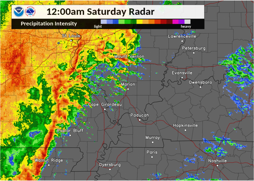
Radar
Here is a radar loop from midnight to 11 AM on Saturday January 11th. The line of storms moved into southeast Missouri around midnight and reached the Pennyrile region of western Kentucky around 6 to 8 AM.
 |
 |
 |
 |
 |
| Radar image from the KPAH radar of the tornado near Ware, IL. | Radar image from the KPAH radar from the tornado near Benton, KY. | Radar image from the KPAH radar of the tornado in the Land Between the Lakes in Trigg County, KY. | Radar image from the KHPX radar of severe storms in Christian County, KY. |
Storm Reports
PRELIMINARY LOCAL STORM REPORT...SUMMARY
NATIONAL WEATHER SERVICE PADUCAH KY
443 PM CST WED JAN 15 2020
..TIME... ...EVENT... ...CITY LOCATION... ...LAT.LON...
..DATE... ....MAG.... ..COUNTY LOCATION..ST.. ...SOURCE....
..REMARKS..
1030 AM FLASH FLOOD 6 ENE ANNA 37.49N 89.15W
01/11/2020 UNION IL LAW ENFORCEMENT
WATER OVER LICK CREEK ROAD CLOSE TO JOHNSON
COUNTY LINE. ALSO A FEW OTHER COUNTY ROADS
WITH WATER OVER THEM.
1008 AM FLASH FLOOD 1 SW POSEYVILLE 38.16N 87.79W
01/11/2020 POSEY IN DEPT OF HIGHWAYS
HIGHWAY 168 AND HIGHWAY 165 CLOSED DUE TO
FLASH FLOODING.
0930 AM FLASH FLOOD 3 N DYCUSBURG 37.20N 88.19W
01/11/2020 CRITTENDEN KY LAW ENFORCEMENT
REPORT OF WATER OVER AXEL CREEK ROAD.
0920 AM FLASH FLOOD ROCKPORT 37.88N 87.05W
01/11/2020 SPENCER IN TRAINED SPOTTER
NUMEROUS ROADS FLOODED AND IMPASSIBLE.
0915 AM HEAVY RAIN 3 SSW MOUND CITY 37.05N 89.18W
01/11/2020 M2.95 INCH BALLARD KY CO-OP OBSERVER
CO-OP OBSERVER STATION CAOI2 2.7 SW MOUND
CITY. THE DURATION OF THE HEAVY RAIN EVENT
WAS 24 HOURS.
0907 AM FLASH FLOOD BIEHLE 37.61N 89.84W
01/11/2020 PERRY MO PUBLIC
FLOODING OF COUNTY ROADS ABOUT BIEHLE, MO.
RELAYED VIA TWITTER.
0906 AM HEAVY RAIN 2 SE HEATH 37.07N 88.77W
01/11/2020 M2.97 INCH MCCRACKEN KY ASOS
ASOS STATION KPAH PADUCAH KY. THE DURATION
OF THE HEAVY RAIN EVENT WAS 24 HOURS.
0902 AM FLASH FLOOD 2 ESE LA CENTER 37.06N 88.93W
01/11/2020 BALLARD KY TRAINED SPOTTER
HINKLEVILLE ROAD IS FLOODED NEAR BROOKING
ROAD. RELAYED VIA TWITTER.
0900 AM FLASH FLOOD 1 ENE DIXON 37.52N 87.67W
01/11/2020 WEBSTER KY LAW ENFORCEMENT
NUMEROUS ROADS THROUGHOUT THE COUNTY HAD
WATER OVER THEM INCLUDING HIGHWAY 132 AND
138.
0853 AM HEAVY RAIN 3 WNW SCOTT CITY 37.23N 89.58W
01/11/2020 M2.55 INCH SCOTT MO ASOS
ASOS STATION KCGI CAPE GIRARDEAU MO.
0843 AM HEAVY RAIN 2 SE PATTERSON 37.17N 90.52W
01/11/2020 M3.62 INCH WAYNE MO COCORAHS
COCORAHS STATION MO-WY-1 PATTERSON 2.0 SE.
0815 AM TSTM WND DMG 4 SW CADIZ 36.84N 87.88W
01/11/2020 TRIGG KY EMERGENCY MNGR
LARGE TREES AT LEAST 3.5 FEET IN DIAMETER
DOWN ALONG MALONE ROAD SOUTHWEST OF CADIZ.
ALSO REPORT OF A TREE THAT CAME DOWN ON A
TRUCK ON HWY 68 NEAR CADIZ.
0805 AM TSTM WND DMG 3 SSE GREENVILLE 37.17N 87.15W
01/11/2020 MUHLENBERG KY LAW ENFORCEMENT
TREES DOWN THROUGHOUT THE COUNTY INLCUDING
ALONG HWY 181 SOUTH OF GREENVILLE.
0800 AM FLASH FLOOD 1 NNE BENTON 36.87N 88.35W
01/11/2020 MARSHALL KY LAW ENFORCEMENT
NUMEROUS ROADS WERE FLOODED ACROSS THE
COUNTY.
0740 AM HEAVY RAIN 1 WNW DEXTER 36.79N 89.97W
01/11/2020 M2.49 INCH STODDARD MO COCORAHS
COCORAHS STATION MO-ST-4 DEXTER 0.6 WNW. THE
DURATION OF THE HEAVY RAIN EVENT WAS 24
HOURS.
0740 AM TORNADO 5 SE HOPKINSVILLE 36.80N 87.44W
01/11/2020 CHRISTIAN KY NWS STORM SURVEY
TORNADO STARTED ABOUT 4 MILES SOUTHEAST OF
HOPKINSVILLE AND WAS ON THE GROUND FOR 2.5
MILES BEFORE LIFTING ABOUT 4.5 MILES ESE OF
HOPKINSVILLE. PEAK WINDS WERE AROUND 95 MPH
AND WIDTH WAS 50 YARDS. SEVERAL TREES WERE
SNAPPED ALONG THE PATH. ONE BARN RECEIVED
SOME PARTIAL DAMAGE TO ITS ROOF.
0740 AM TSTM WND DMG 3 NE HOPKINSVILLE 36.89N 87.46W
01/11/2020 CHRISTIAN KY EMERGENCY MNGR
NUMEROUS TREES DOWN ALONG GREENVILLE ROAD.
0739 AM TSTM WND DMG 4 SE HOPKINSVILLE 36.82N 87.43W
01/11/2020 CHRISTIAN KY TRAINED SPOTTER
ELEVEN RAIL CARS DERAILED AT CASKY LANE.
TIME ESTIMATED.
0737 AM TSTM WND GST 2 WNW FORT CAMPBELL NOR 36.67N 87.50W
01/11/2020 M64 MPH CHRISTIAN KY AWOS
AWOS STATION KHOP FORT CAMPBELL KY.
0736 AM TSTM WND DMG 1 SW HOPKINSVILLE 36.84N 87.51W
01/11/2020 CHRISTIAN KY TRAINED SPOTTER
ROOF DAMAGE REPORTED TO HOPKINSVILLE HIGH
SCHOOL. TIME ESTIMATED.
0735 AM DOWNBURST 2 NNW HOPKINSVILLE 36.88N 87.51W
01/11/2020 CHRISTIAN KY NWS STORM SURVEY
A DOWNBURST OCCURRED ON THE NORTH SIDE OF
HOPKINSVILLE. NUMEROUS TREES WERE UPROOTED
OR SNAPPED AT THE BASE. APPROXIMATELY 125
HOMES WERE DAMAGED. MOST HAD
ROOF/SOFFIT/SIDING DAMAGE. HOWEVER AT LEAST
ONE HAD A TREE FALL ON THE HOUSE AND
SEVERELY DAMAGED IT. AT LEAST 1 POWER POLE
WAS SNAPPED. SIGNIFICANT DAMAGE OCCURRED AT
RUFF PARK. DAMAGE WIDTH WAS .9 MILES, LENGTH
WAS 1.6 MILES. PEAK WINDS 100 MPH.
0734 AM TORNADO 3 NW OAK GROVE 36.69N 87.46W
01/11/2020 CHRISTIAN KY NWS STORM SURVEY
TORNADO STARTED APPROXIMATELY 4 MILES WNW OF
OAK GROVE AND WAS ON THE GROUND FOR 11 MILES
BEFORE LIFTING 2.5 MILES NORTHWEST OF
PEMBROKE. PEAK WINDS WERE 100 MPH AND WIDTH
WAS 100 YARDS. SEVERAL BARNS WERE DAMAGED OR
DESTROYED. TREES WERE UPROOTED AND SNAPPED
AND A COUPLE HOMES RECEIVED SOME MINOR
DAMAGE.
0728 AM HEAVY RAIN 1 SW CRAINVILLE 37.74N 89.08W
01/11/2020 M2.62 INCH WILLIAMSON IL COCORAHS
COCORAHS STATION IL-WM-14 , IL. THE DURATION
OF THE HEAVY RAIN EVENT WAS 24 HOURS.
0720 AM TSTM WND DMG 2 WSW HAWKINS 37.02N 87.68W
01/11/2020 CHRISTIAN KY TRAINED SPOTTER
TREES DOWN ALONG ROGERS ROAD. TIME
APPROXIMATE.
0719 AM TORNADO 2 N HAWKINS 37.06N 87.65W
01/11/2020 CHRISTIAN KY NWS STORM SURVEY
NWS STORM SURVEY FOUND AN EF-1 TORNADO WITH
ESTIMATED PEAK WINDS OF 90 MPH BEGAN AT 7:19
AM AND ENDED AT 7:23 AM. A FEW BARNS WERE
DAMAGED OR BLOWN DOWN. A COUPLE HOUSES
SUSTAINED LOSS OF SHINGLES AND FACIA. AT
LEAST DOZENS OF TREES WERE UPROOTED OR
SNAPPED. THE PATH LENGTH WAS 3.27 MILES AN
THE MAXIMUM WIDTH WAS 200 YARDS.
0715 AM FLASH FLOOD 1 NNW METROPOLIS 37.17N 88.72W
01/11/2020 MASSAC IL NWS EMPLOYEE
SIX TO EIGHT INCHES OF FLOWING WATER OVER 30
TO 40 FOOT SECTION OF COMMERCIAL PARK ROAD
AT ENTRANCE TO PHEASANT COVE SUBDIVISION.
0712 AM TORNADO 7 SE PRINCETON 37.05N 87.78W
01/11/2020 CALDWELL KY NWS STORM SURVEY
NWS STORM SURVEY FOUND AN EF-1 TORNADO WITH
ESTIMATED PEAK WINDS OF 95 MPH STARTED AT
7:12 AM AND LIFTED AT 7:20 AM. THE TORNADO
LEFT HUNDREDS OF TREES UPROOTED OR SNAPPED.
THE PATH LENGTH WAS 7.66 MILES AND THE
MAXIMUM WIDTH WAS 175 YARDS.
0710 AM TORNADO CADIZ 36.87N 87.82W
01/11/2020 TRIGG KY AMATEUR RADIO
UPDATED TIME BASED ON RADAR. CORRECTS
PREVIOUS TORNADO REPORT FROM CADIZ. RAIN
WRAPPED TORNADO SIGHTED BY HAM RADIO
OPERATOR, NEAR HIS HOME, JUST EAST OF CADIZ.
0710 AM TSTM WND DMG 6 WNW CERULEAN 37.01N 87.80W
01/11/2020 CALDWELL KY EMERGENCY MNGR
PARTIAL ROOF DAMAGE TO 3 HOMES ALONG HARMONY
CHURCH ROAD. ALSO A BARN DESTROYED ALONG HWY
514. TREE DOWN ON POWER LINE NEAR HWY 139
AND HWY 126 INTERSECTION.
0705 AM TORNADO 7 WNW CERULEAN 36.98N 87.84W
01/11/2020 CALDWELL KY NWS STORM SURVEY
NWS STORM SURVEY FOUND AN EF-1 TORNADO WITH
ESTIMATED PEAK WINDS OF 100 MPH STARTED AT
7:05 AM AND ENDED AT 7:19 AM. AT LEAST A
HALF DOZEN BARNS OR OUTBUILDING DAMAGED OR
DESTROYED. FOUR WOODEN HIGH TENSION POWER
POLES TAKEN DOWN AND AT LEAST DOZENS OF
TREES SNAPPED OR UPROOTED. THE PATH LENGTH
WAS 10 MILES AND THE MAX WIDTH WAS 250
YARDS.
0705 AM TSTM WND DMG 2 W CADIZ 36.87N 87.86W
01/11/2020 TRIGG KY EMERGENCY MNGR
NUMEROUS TREES DOWN AND SOME BUILDINGS
DAMAGED ON RAINBOW HILL. POSSIBLE TORNADO.
0703 AM FLASH FLOOD EVANSVILLE 37.98N 87.54W
01/11/2020 VANDERBURGH IN TRAINED SPOTTER
CORRECTS PREVIOUS FLOOD REPORT FROM
EVANSVILLE. 1.2 INCHES IN LAST HOUR AND
FLOODING IN ANGEL MOUNDS OR THE SOUTHEAST
SIDE OF EVANSVILLE.
0703 AM FLOOD EVANSVILLE 37.98N 87.54W
01/11/2020 VANDERBURGH IN TRAINED SPOTTER
1.2 INCHES IN LAST HOUR AND FLOODING IN
ANGEL MOUNDS OR THE SOUTHEAST SIDE OF
EVANSVILLE.
0700 AM FLASH FLOOD PINCKNEYVILLE 38.08N 89.38W
01/11/2020 PERRY IL PUBLIC
CORRECTS PREVIOUS FLOOD REPORT FROM
PINCKNEYVILLE. 3 INCHES RAINFALL AND
FLOODING.
0700 AM FLOOD PINCKNEYVILLE 38.08N 89.38W
01/11/2020 PERRY IL PUBLIC
3 INCHES RAINFALL AND FLOODING.
0700 AM HEAVY RAIN 2 W SIKESTON 36.88N 89.62W
01/11/2020 M2.50 INCH SCOTT MO CO-OP OBSERVER
CO-OP OBSERVER STATION SKSM7 SIKESTON MO
POWER STATION.
0700 AM HEAVY RAIN 1 SSW SAINT JOHNS 38.02N 89.25W
01/11/2020 M2.80 INCH PERRY IL COCORAHS
COCORAHS STATION IL-PY-2 SAINT JOHNS IL 1
SSW.
0700 AM HEAVY RAIN 5 NNW GOREVILLE 37.63N 89.00W
01/11/2020 M2.54 INCH WILLIAMSON IL COCORAHS
COCORAHS STATION IL-WM-12 MARION IL 8 SSW.
0700 AM HEAVY RAIN 1 NNE PADUCAH 37.09N 88.63W
01/11/2020 M2.51 INCH MCCRACKEN KY COCORAHS
COCORAHS STATION KY-MK-8 PADUCAH KY 1 NNE.
0700 AM HEAVY RAIN ROSICLARE 37.42N 88.35W
01/11/2020 M3.12 INCH HARDIN IL CO-OP OBSERVER
CO-OP OBSERVER STATION ROSI2 ROSICLARE IL 5
NW.
0700 AM HEAVY RAIN 2 N GOLCONDA 37.39N 88.49W
01/11/2020 M3.60 INCH POPE IL COCORAHS
COCORAHS STATION IL-PP-4 GOLCONDA IL 2 N.
0700 AM HEAVY RAIN 2 ENE NEW BURNSIDE 37.59N 88.74W
01/11/2020 M2.72 INCH JOHNSON IL COCORAHS
COCORAHS STATION IL-JH-1 NEW BURNSIDE 1.8
ENE.
0700 AM HEAVY RAIN 2 SE CAPE GIRARDEAU 37.29N 89.53W
01/11/2020 M2.74 INCH CAPE GIRARDEAU MO COCORAHS
COCORAHS STATION MO-CG-12 CAPE GIRARDEAU MO
1.8 SE.
0700 AM HEAVY RAIN 2 SW LONE OAK 37.02N 88.68W
01/11/2020 M3.03 INCH MCCRACKEN KY COCORAHS
COCORAHS STATION KY-MK-6 PADUCAH KY 4.5 SW.
0700 AM HEAVY RAIN 2 WNW PERRYVILLE 37.73N 89.92W
01/11/2020 M3.03 INCH PERRY MO CO-OP OBSERVER
CO-OP OBSERVER STATION PRRM7 PERRYVILLE MO
WATER PLANT.
0700 AM HEAVY RAIN 5 WNW ELLSINORE 36.97N 90.82W
01/11/2020 M3.64 INCH CARTER MO COCORAHS
COCORAHS STATION MO-CT-1 ELLSINORE MO 4.8
WNW.
0700 AM HEAVY RAIN 8 WSW GRANDIN 36.80N 90.97W
01/11/2020 M3.97 INCH RIPLEY MO COCORAHS
COCORAHS STATION MO-RP-7 DONIPHAN 14.5 NW.
0700 AM HEAVY RAIN 2 N PINCKNEYVILLE 38.10N 89.38W
01/11/2020 M2.70 INCH PERRY IL CO-OP OBSERVER
CO-OP OBSERVER STATION PNKI2 PINCKNEYVILLE 2
N.
0700 AM HEAVY RAIN 1 N CAIRO 37.01N 89.18W
01/11/2020 M2.57 INCH ALEXANDER IL COCORAHS
COCORAHS STATION IL-AL-2 CAIRO, IL.
0700 AM HEAVY RAIN 1 E SCOTT CITY 37.22N 89.52W
01/11/2020 M2.60 INCH SCOTT MO COCORAHS
COCORAHS STATION MO-SC-5 SCOTT CITY MO 0.9
E.
0700 AM HEAVY RAIN 3 NE MOUNT VERNON 38.35N 88.87W
01/11/2020 M2.60 INCH JEFFERSON IL CO-OP OBSERVER
CO-OP OBSERVER STATION MVNI2 MOUNT VERNON IL
3 NE.
0700 AM HEAVY RAIN 2 WSW OAK RIDGE 37.49N 89.76W
01/11/2020 M2.66 INCH CAPE GIRARDEAU MO COCORAHS
COCORAHS STATION MO-CG-14 OAK RIDGE MO 1
WSW.
0700 AM HEAVY RAIN 1 WNW ROUND KNOB 37.26N 88.76W
01/11/2020 M2.79 INCH MASSAC IL COCORAHS
COCORAHS STATION IL-MC-1 ROUND KNOB IL 1
WNW.
0700 AM HEAVY RAIN 2 S RALEIGH 37.80N 88.53W
01/11/2020 M2.49 INCH SALINE IL COCORAHS
COCORAHS STATION IL-SL-1 HARRISBURG IL 4.6
NNE.
0700 AM TORNADO 3 NNE CANTON 36.83N 87.93W
01/11/2020 TRIGG KY NWS STORM SURVEY
THE TORNADO TOUCHED DOWN JUST EAST OF BLUE
SPRING AND TRACKED EASTWARD JUST NORTH OF
BLUE SPRING ROAD. IT CONTINUED EAST
NORTHEAST TO JUST SOUTHWEST OF CADIZ. THE
PATH LENGTH WAS 4.4 MILES, WITH PEAK WINDS
OF 85 MPH, AND MAXIMUM WIDTH OF 50 YARDS.
SEVERAL TREES WERE SNAPPED AND/OR UPROOTED.
THERE WERE SEVERAL HOMES WITH MINOR ROOF
DAMAGE AND ONE THAT HAD MODERATE ROOF
DAMAGE. ONE METAL BUILDING HAD ITS GARAGE
DOOR BLOWN IN. A LARGE BRANCH FELL ON A
VEHICLE AT ONE RESIDENCE. A CARPORT WAS
SHIFTED OFF ITS SUPPORTS.
0656 AM TSTM WND DMG CANTON 36.80N 87.96W
01/11/2020 TRIGG KY TRAINED SPOTTER
TREES DOWN AND ROOF DAMAGE BETWEEN CANTON
AND CADIZ. TIME ESTIMATED.
0650 AM TORNADO 6 SE AURORA 36.72N 88.07W
01/11/2020 TRIGG KY NWS STORM SURVEY
THE TORNADO TOUCHED DOWN IN THE REDD HOLLOW
AREA WEST OF THE TRACE IN LBL. DAMAGE
CONTINUED TO JUST SOUTH OF THE WRANGLERS
CAMPGROUND. THE TORNADO COULD HAVE CROSSED
INTO LAKE BARKLEY AND DONALDSON CREEK, BUT
NO EVIDENCE WAS FOUND FURTHER EAST. PEAK
WINDS WERE 105 MPH WITH PEAK WIDTH OF 75
YARDS. THE PATH LENGTH WAS 4.4 MILES. THE
HEAVIEST AREA OF DAMAGE WAS SOUTH OF
WRANGLERS CAMPGROUND, WHERE MANY DOZENS OF
TREES WERE SNAPPED AND UPROOTED. JUST SOUTH
OF THE TRACK A MICROBURST OCCURRED WHERE
MANY TREES WERE SNAPPED AND UPROOTED.
0650 AM TSTM WND DMG 5 SW HAMLIN 36.55N 88.15W
01/11/2020 CALLOWAY KY LAW ENFORCEMENT
SEVERAL TREES DOWN AROUND THE NEW CONCORD
AREA ALONG HIGHWAYS 280, 444, AND 893.
0600 AM FLASH FLOOD 2 SW MOUNT CARMEL 38.40N 87.79W
01/11/2020 WABASH IL LAW ENFORCEMENT
LATE REPORT, TIME ESTIMATED. HIGHWAY 1 SOUTH
OF MOUNT CARMEL IS IMPASSABLE DUE TO WATER
OVER ROAD.
0550 AM TSTM WND DMG 6 NNE BENTON 36.93N 88.31W
01/11/2020 MARSHALL KY TRAINED SPOTTER
CARPORT BLOWN INTO YARD FROM NEIGHBORS. ALSO
A FEW SHINGLES IN YARD. THIS IS NEAR
INTERSECTION OF HWY 1422 AND BRIENSBURG
TATUMSVILLE ROAD IN TATUMSVILLE.
0545 AM TSTM WND DMG 1 NNW BENTON 36.87N 88.37W
01/11/2020 MARSHALL KY LAW ENFORCEMENT
PARTIAL ROOF COLLAPSE OF WALMART IN BENTON.
NUMEROUS TREES DOWN THROUGHOUT THE COUNTY
INCLUDING ON SYMSONIA HWY NW OF BENTON,
VANZORA ROAD NEAR GRAVES COUNTY LINE, AND IN
THE GILBERTSVILLE AREA.
0542 AM TORNADO 1 W BENTON 36.85N 88.38W
01/11/2020 MARSHALL KY NWS STORM SURVEY
EF1 TORNADO TOUCHED DOWN NEAR THE 641 EXIT
ON I-69. MAINLY DAMAGED TREES ALONG THE
PATH. ONE BARN LOST ITS ROOF. MAX WIDTH 25
YARDS. MAX WIND 80 MPH. PATH LENGTH 2.3
MILES. THERE WAS OTHER STRAIGHT LINE WIND
DAMAGE IN THE AREA.
0530 AM TSTM WND DMG 3 ESE WINGO 36.62N 88.70W
01/11/2020 GRAVES KY LAW ENFORCEMENT
3 BARNS DAMAGED ALONG WOODSON ROAD.
0340 AM FLASH FLOOD 1 N DELTA 37.21N 89.74W
01/11/2020 CAPE GIRARDEAU MO EMERGENCY MNGR
SEVERAL ROADS IMPASSABLE AND COVERED WITH
WATER IN SOUTHERN PART OF CAPE GIRARDEAU
COUNTY. INCLUDED ARE STATE ROUTE N AND
COUNTY ROAD 244, HIGHWAY P BETWEEN RANDLES
AND DELTA, AND STATE ROUTE N AND COUNTY ROAD
236.
0300 AM FLASH FLOOD 3 SSE CHICOPEE 36.94N 90.99W
01/11/2020 CARTER MO DEPT OF HIGHWAYS
CORRECTED THE TIME AND ESTIMATED IT BY
RADAR. SEVERAL ROADS CLOSED ACROSS CARTER
COUNTY DUE TO WATER OVER THEM, INCLUDING
PORTIONS OF ROUTE Z, ROUTE K, AND ROUTE M.
0300 AM FLASH FLOOD 1 W OXLY 36.59N 90.71W
01/11/2020 RIPLEY MO DEPT OF HIGHWAYS
CORRECTED THE TIME AND ESTIMATED IT BY
RADAR. SEVERAL ROADS CLOSED ACROSS RIPLEY
COUNTY DUE TO WATER OVER THEM, INCLUDING
PORTIONS OF ROUTE H AND COUNTY ROAD 142 IN
THE SOUTHEAST PART OF COUNTY AND ROUTE NN
AND K IN NORTHEAST PART OF COUNTY.
0238 AM TSTM WND DMG HERRIN 37.81N 89.02W
01/11/2020 WILLIAMSON IL PUBLIC
REPORT FROM MPING: 1-INCH TREE LIMBS BROKEN;
SHINGLES BLOWN OFF.
0202 AM TORNADO WARE 37.44N 89.40W
01/11/2020 UNION IL NWS STORM SURVEY
THE TORNADO SNAPPED LARGE TREE BRANCHES IN
THE TOWN OF WARE. METAL ROOFING WAS REMOVED
FROM A FARM OUTBUILDING. A LARGE OPEN
STORAGE BUILDING WAS OVERTURNED AND
DESTROYED. SHINGLES WERE REMOVED FROM THE
ROOF OF A HUNTING CLUB. ANOTHER HOME HAD ITS
ROOF LIFTED SLIGHTLY BY THE TORNADO CAUSING
WATER DAMAGE. THE ROOF OF A METAL STORAGE
BUILDING WAS LOFTED AND OVERTURNED. HUNDREDS
OF DECOY DUCKS WERE TOSSED AND BROKEN NEAR
THE HUNTING CLUB. NUMEROUS TREES WERE
SNAPPED OR UPROOTED ALONG THE PATH OF THE
TORNADO. ESTIMATED PEAK WINDS WERE 100 MPH.
PATH LENGTH WAS 0.9 MILES. ESTIMATED MAX
WIDTH WAS 50 YARDS.
0201 AM TSTM WND GST 1 W CARBONDALE 37.73N 89.24W
01/11/2020 M70 MPH JACKSON IL ASOS
.
0200 AM TSTM WND DMG WARE 37.45N 89.40W
01/11/2020 UNION IL BROADCAST MEDIA
LARGE TREE DOWN IN WARE. CARPORT DESTROYED.
ROOF PEELED BACK ON A GARAGE.
0155 AM TSTM WND DMG CAPE GIRARDEAU 37.31N 89.55W
01/11/2020 CAPE GIRARDEAU MO BROADCAST MEDIA
TREE BLOWN DOWN ON HOUSE IN TOWN.
0148 AM TSTM WND DMG 3 SE JACKSON 37.35N 89.61W
01/11/2020 CAPE GIRARDEAU MO EMERGENCY MNGR
FOUR BUILDINGS ON BIRK LANE DAMAGED,
INCLUDING ROOF DAMAGE TO CRADER TIRE.
0142 AM TORNADO 3 SE JACKSON 37.35N 89.62W
01/11/2020 CAPE GIRARDEAU MO NWS STORM SURVEY
A EF2 TORNADO TOUCHED DOWN SOUTHEAST OF
JACKSON, MISSOURI AND CONTINUED NORTHEAST
FOR 9.7 MILES. PEAK WINDS WERE 125 MPH AND
THE MAXIMUM WIDTH WAS 300 YARDS. SEE PUBLIC
INFORMATION STATEMENT FOR DETAILS.
1252 AM TORNADO 1 NE PATTON 37.52N 89.99W
01/11/2020 BOLLINGER MO NWS STORM SURVEY
A EF1 TORNADO WITH PEAK WINDS OF 105 MPH
BRIEFLY TOUCHED DOWN AND DESTROYED THE
WORKSHOP PORTION OF A WORKSHOP/HOME
COMBINATION BUILDING. WIDTH ABOUT 45 YARDS
WIDE. ALSO TORN OFF ROOF OF NEARBY BARN. A
FEW TREES WERE UPROOTED.
1250 AM TSTM WND DMG 6 E NEELYVILLE 36.55N 90.39W
01/11/2020 BUTLER MO EMERGENCY MNGR
PARTIAL ROOF BLOWN OFF OF A HOUSE ALONG
COUNTY ROAD 257 EAST OF NEELYVILLE. TIME
ESTIMATED BY RADAR.
1247 AM FLASH FLOOD PIEDMONT 37.15N 90.70W
01/11/2020 WAYNE MO LAW ENFORCEMENT
WATER COMING OVER BRIDGES IN SEVERAL PLACES
IN PIEDMONT, MO. LOCATION 1) MO34 AT PUMP
HOUSE ROAD, WATER COMING OVER THE BRIDGE.
LOCATION 2) MO34 AT THE AARP BUILDING NEAR
HIGH SCHOOL, WATER OVER THE BRIDGE.
AUTHORITY WAYNE COUNTY SHERIFFS OFFICE.
0853 PM HEAVY RAIN 8 W DEXTER 36.79N 90.10W
01/10/2020 M1.00 INCH STODDARD MO TRAINED SPOTTER
1.44 INCH OF RAIN SINCE MIDNIGHT.
0640 PM FLOOD 7 N MARBLE HILL 37.40N 89.98W
01/10/2020 BOLLINGER MO EMERGENCY MNGR
NUMEROUS LOW WATER CROSSING ARE NOW FLOODING
ACROSS THE COUNTY FROM PREVIOUS RAINFALL
TODAY, INCLUDING COUNTY ROADS 356, 366, 364,
234, 236, 400, 408 AND 414. ALSO, MO HWY V
HAS WATER OVER IT.
0630 PM HEAVY RAIN 3 SE EVANSVILLE 37.95N 87.50W
01/10/2020 M1.00 INCH VANDERBURGH IN TRAINED SPOTTER
1.4 INCHES OF RAIN TOTAL SO FAR.
Rain Reports
 |
Public Information Statement
National Weather Service Paducah KY
202 PM CST Sat Jan 11 2020

...PRELIMINARY 48 HOUR PRECIPITATION REPORTS...

Location                     Amount    Time/Date       Provider

...Illinois...

...Alexander County...
Bean Ridge                   4.01 in   0108 PM 01/11   RAWS
0.9 NW Thebes                3.28 in   0100 PM 01/11   HADS

...Edwards County...
Albion                       3.88 in   0700 AM 01/11   COCORAHS
Albion 1.4 E                 3.87 in   0700 AM 01/11   COCORAHS

...Franklin County...
2.0 E Zeigler                5.12 in   0100 PM 01/11   COOP
Benton 1 NE                  3.35 in   0702 AM 01/11   COCORAHS

...Hardin County...
Rosiclare 5 NW               3.39 in   0700 AM 01/11   COOP

...Jackson County...
De Soto 0.3 ESE              4.00 in   0700 AM 01/11   COCORAHS
Carbondale 1.2 W             3.91 in   0700 AM 01/11   COCORAHS
Carbondale                   3.87 in   1252 PM 01/11   ASOS
Carbondale 2.5 W             3.81 in   0700 AM 01/11   COCORAHS
Grand Tower                  2.20 in   0100 PM 01/11   HADS
0.8 SE Murphysboro           2.14 in   0100 PM 01/11   HADS

...Jefferson County...
Mount Vernon 3 NE            3.55 in   0700 AM 01/11   COOP
Mount Vernon 5.2 SSW         3.32 in   0800 AM 01/11   COCORAHS
Ashley                       3.02 in   0133 PM 01/11   CWOP
Mount Vernon                 2.86 in   1256 PM 01/11   AWOS
Dix                          2.73 in   0133 PM 01/11   CWOP

...Johnson County...
New Burnside 1.8 ENE         3.86 in   0700 AM 01/11   COCORAHS
Goreville                    3.62 in   0134 PM 01/11   AWS

...Massac County...
Round Knob 1 WNW             2.82 in   0700 AM 01/11   COCORAHS
Metropolis                   2.78 in   0115 PM 01/11   AWOS
Brookport 7.3 ENE            2.06 in   0700 AM 01/11   COCRAHS

...Perry County...
Pinckneyville 2 N            3.41 in   0700 AM 01/11   COOP
Du Quoin                     2.48 in   0135 PM 01/11   AWS

...Pope County...
Dixon Springs                3.35 in   0108 PM 01/11   RAWS

...Saline County...
Harrisburg 4.6 NNE           3.76 in   0700 AM 01/11   COCORAHS
Harrisburg                   3.47 in   0135 PM 01/11   AWOS

...Union County...
Dongola                      3.60 in   0756 AM 01/11   COCORAHS

...Wayne County...
Fairfield                    3.13 in   0115 PM 01/11   AWOS
1 N Wayne City               2.37 in   0515 AM 01/11   HADS

...White County...
Crossville 3.0 E             3.11 in   0700 AM 01/11   COCORAHS

...Williamson County...
Marion 1 NNE                 4.31 in   0130 PM 01/11   COCORAHS
Carterville 1.6 SSE          4.08 in   0728 AM 01/11   COCORAHS
Marion 8 SSW                 3.82 in   0700 AM 01/11   COCORAHS
Marion                       3.60 in   0135 PM 01/11   AWS
Crainville                   3.58 in   0135 PM 01/11   AWS

...Indiana...

...Gibson County...
Oakland City                 3.87 in   0134 PM 01/11   CWOP
Francisco 0.1 SE             3.47 in   0654 AM 01/11   COCORAHS

...Pike County...
Petersburg 1 ENE             3.35 in   0500 AM 01/11   COCORAHS
Holland 6.3 NW               2.28 in   0600 AM 01/11   COCORAHS

...Posey County...
Poseyville 2.9 SSE           3.66 in   0700 AM 01/11   COCORAHS
Poseyville 2.8 NW            3.53 in   0700 AM 01/11   COCORAHS
Mount Vernon                 3.33 in   0600 AM 01/11   COOP
2 N Mount Vernon             3.26 in   0135 PM 01/11   AWS
Wadesville                   3.23 in   0126 PM 01/11   CWOP

...Vanderburgh County...
2.0 W Evansville             4.09 in   0100 PM 01/11   COOP
Evansville 10 NW             3.68 in   0700 AM 01/11   COCORAHS
Evansville                   3.65 in   0107 PM 01/11   ASOS
Evansville Museum            3.38 in   0400 PM 01/11   COOP
Evansville 5.9 WNW           3.47 in   0700 AM 01/11   COCORAHS
Evansville 3.5 ESE           2.21 in   0800 AM 01/11   COCORAHS

...Warrick County...
1.4 N Newburgh               2.50 in   0100 PM 01/11   COOP
Newburgh                     2.36 in   0130 PM 01/11   CWOP

...Kentucky...

...Ballard County...
1.4 E Olmsted                2.62 in   0100 PM 01/11   UCOOP

...Caldwell County...
Princeton 2 SE               1.96 in   0130 PM 01/11   KYMN2

...Calloway County...
New Concord                  2.72 in   0133 PM 01/11   CWOP
1.6 SE Murray                2.30 in   0100 PM 01/11   HADS
Murray 1 W                   1.89 in   0130 PM 01/11   KYMN2
Murray                       1.75 in   0126 PM 01/11   CWOP

...Christian County...
Princeton                    2.10 in   0131 PM 01/11   CWOP
Hopkinsville 6 N             1.95 in   0130 PM 01/11   KYMN2

...Crittenden County...
Marion 4 NE                  2.30 in   0130 PM 01/11   KYMN2
Marion                       2.03 in   0700 AM 01/11   COOP

...Daviess County...
Owensboro                    2.07 in   0103 PM 01/11   AWOS

...Fulton County...
Hickman 2 E                  2.85 in   0130 PM 01/11   KYMN2
Fulton 5.0 W                 1.89 in   0600 AM 01/11   COCORAHS

...Graves County...
Mayfield 6 SW                1.96 in   0130 PM 01/11   KYMN2

...Henderson County...
Henderson                    2.45 in   0123 PM 01/11   AWOS
Henderson 5 E                1.89 in   0130 PM 01/11   KYMN2

...Hopkins County...
Madisonville 4 S             1.96 in   0130 PM 01/11   KYMN2

...Livingston County...
1.9 W Grand Rivers           1.96 in   1245 PM 01/11   COOP

...Marshall County...
Benton 4 N                   2.16 in   0130 PM 01/11   KYMN2
Calvert City 2.5 SSW         1.87 in   0800 AM 01/11   COCORAHS

...McCracken County...
Paducah                      3.34 in   0108 PM 01/11   ASOS
West Paducah 3.1 SSW         3.11 in   0900 AM 01/11   COCORAHS
Paducah 1 NNE                2.59 in   0700 AM 01/11   COCORAHS

...McLean County...
Calhoun 5 NW                 2.03 in   0130 PM 01/11   KYMN2

...Muhlenberg County...
Greenville 6 N               2.00 in   0130 PM 01/11   KYMN2

...Trigg County...
Cadiz 4 SW                   2.28 in   0130 PM 01/11   KYMN2
Golden Pond                  2.09 in   0121 PM 01/11   RAWS
7.7 SW Gracey                1.75 in   1200 PM 01/11   HADS

...Union County...
Morganfield 4 E              2.63 in   0130 PM 01/11   KYMN2

...Missouri...

...Butler County...
Poplar Bluff MO              2.95 in   0130 PM 01/11   ASOS

...Cape Girardeau County...
Jackson                      5.42 in   0700 AM 01/11   COOP
Cape Girardeau  1.8 SE       4.22 in   0700 AM 01/11   COCORAHS
Oak Ridge 1 WSW              4.18 in   0700 AM 01/11   COCORAHS
1.8 E Cape Girardeau         4.02 in   0100 PM 01/11   HADS
3.4 W Ware                   3.39 in   0100 PM 01/11   HADS

...Carter County...
Ellsinore 4.8 WNW            5.24 in   0700 AM 01/11   COCORAHS

...Mississippi County...
4.9 S Cache                  2.36 in   0100 PM 01/11   HADS
Charleston South             2.31 in   0135 PM 01/11   MOCOMAGNET
2 SE Cairo                   1.91 in   0100 PM 01/11   HADS

...Perry County...
Perryville Water Plant       3.96 in   0700 AM 01/11   COOP
3 NE Farrar                  2.88 in   0100 PM 01/11   HADS

...Ripley County...
Doniphan 14.5 NW             4.87 in   0700 AM 01/11   COCORAHS
Doniphan MO                  3.28 in   1253 PM 01/11   RAWS
Fairdealing MO 6 W           3.23 in   0500 AM 01/11   COCORAHS

...Scott County...
Cape Girardeau               4.40 in   1253 PM 01/11   ASOS
Scott City 0.9 E             3.43 in   0700 AM 01/11   COCORAHS
Sikeston Power Station       2.86 in   0700 AM 01/11   COOP
Sikeston 1.7 ENE             1.98 in   0600 AM 01/11   COCORAHS

...Stoddard County...
Dexter 0.6 WNW               2.62 in   0740 AM 01/11   COCORAHS

...Wayne County...
2.6 E Patterson              4.65 in   1245 PM 01/11   HADS
Piedmont                     4.60 in   1230 PM 01/11   RAWS
0.7 W Greenville             3.89 in   0100 PM 01/11   HADS
0.8 W Wappapello             3.75 in   0100 PM 01/11   COOP
 |
Media use of NWS Web News Stories is encouraged! Please acknowledge the NWS as the source of any news information accessed from this site. |
|

