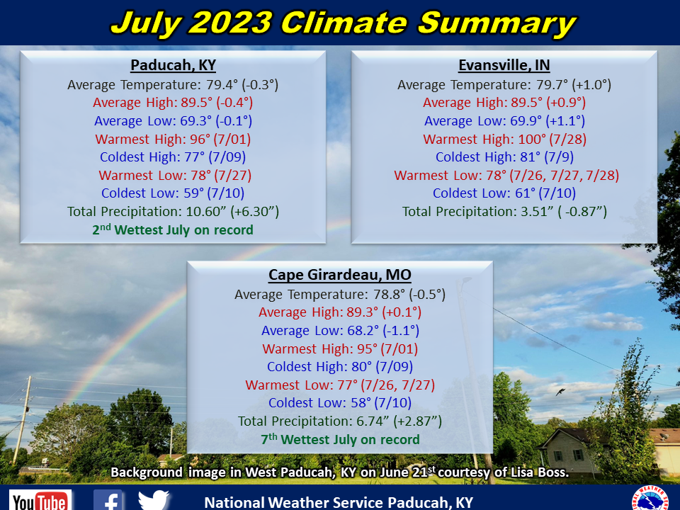
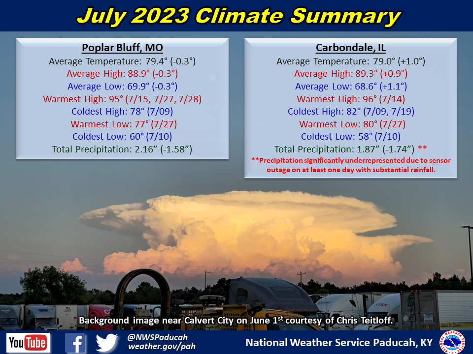
July 2023 Climate Review:
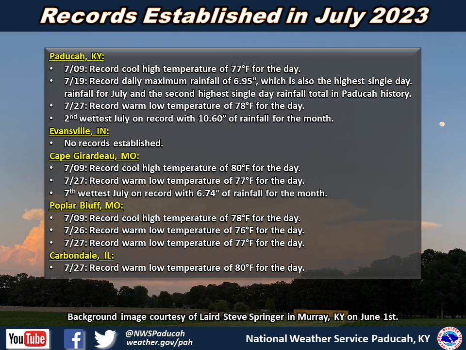
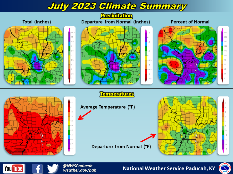
Temperatures averaged around 0.5 degrees below normal across southern portions of the region. However, areas from Carbondale, IL to Evansville, IN registered temperatures around 1 degree above normal. The month started off warm with highs in the upper 80s to mid 90s from the 1st through the 8th. Many areas observed their coolest high temperatures of the month on the 9th, with readings only topping out in the 70s to low 80s. Lows on the morning of the 10th dipped into the 50s. Highs once again returned to the upper 80s and 90s from the 11th through 17th. A cooler stretch was observed from the 19th through 22nd when highs only reached the low to mid 80s. The last week of the month featured plenty of heat and humidity, with temperatures peaking on the 27th-28th in the mid 90s to around 100. Heat index readings of 105 to 115 were observed these two days. The overnight lows were particularly balmy from the 26th through 28th with mid 70s to around 80. Carbondale’s low of 80 on July 27th was their warmest low temperature since July 2012.
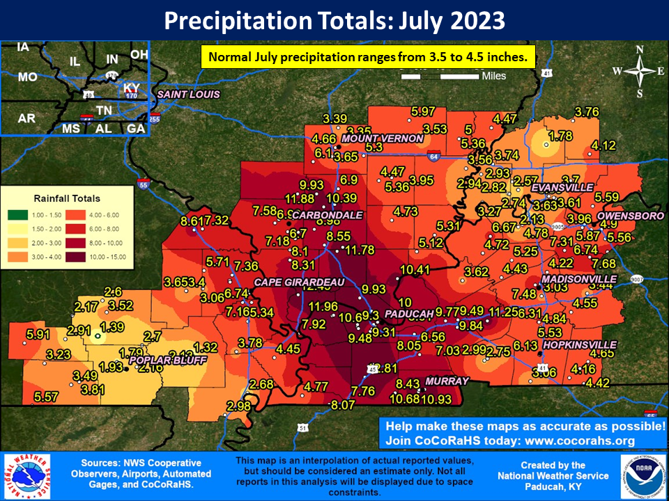
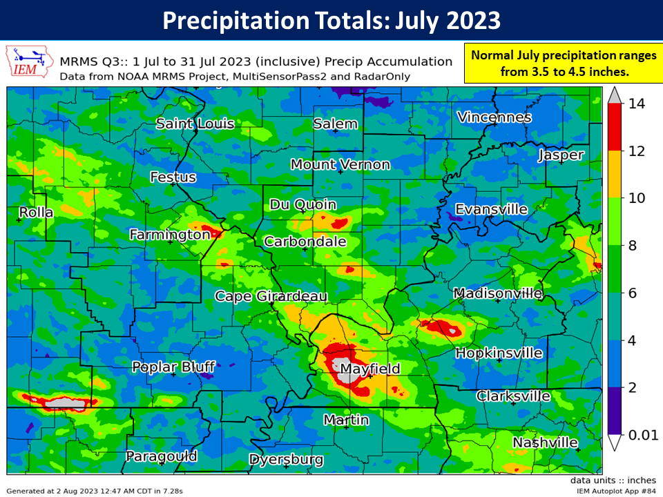
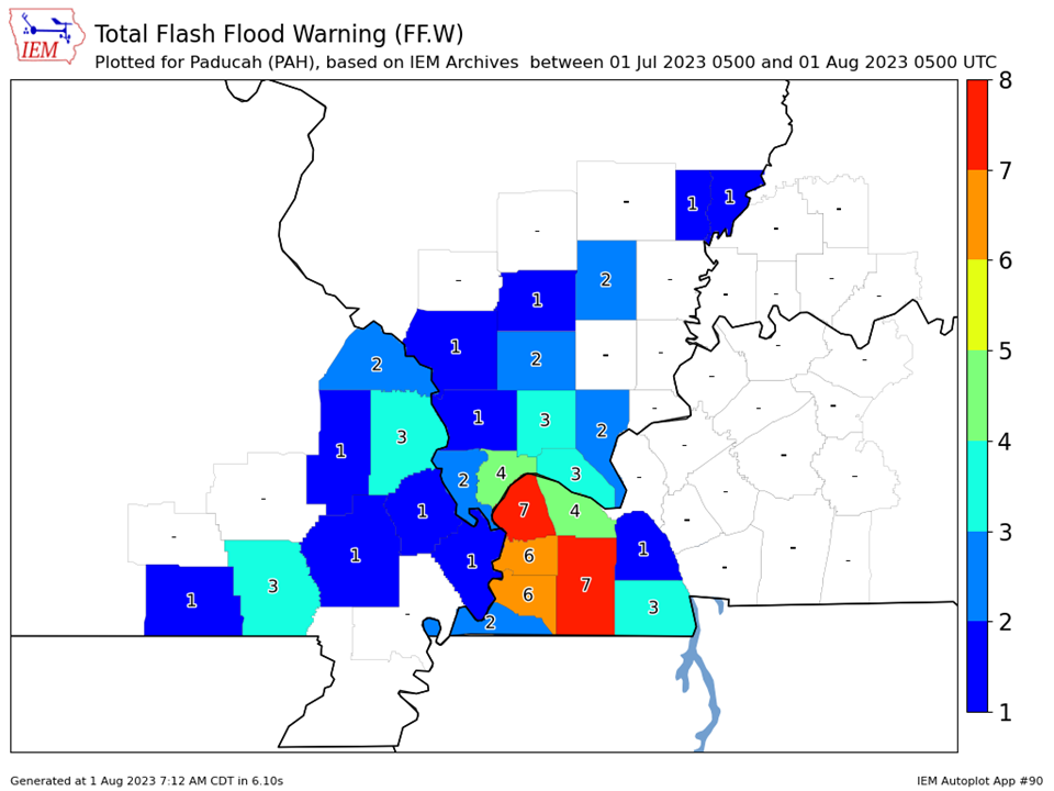
Precipitation varied across the region. The story of the month was the excessively wet conditions across the Jackson Purchase area of west Kentucky that extended northwest into southwest Illinois and portions of southeast Missouri along the Mississippi River. This region observed amounts over 6” and included a swath of even higher amounts ranging from 10 to 15”. The hardest hit area was Graves County including the city of Mayfield. The COOP station 2 miles north of town registered a whopping 14.73”! A large amount of this rain occurred on the morning of July 19th. The KY mesonet station 6 miles southwest of Mayfield recorded 11.28”, setting a new state record for the most rain in a 24 hour period. Paducah officially finished as their 2nd wettest July, while Cape Girardeau checked in as their 7th wettest. Carbondale likely would have finished in the top 10 wettest as well, but a sensor outage occurred during the July 19th heavy rainfall day. On the flip side, much of southeast Missouri further removed from the Mississippi River and also southwest Indiana observed drier than normal conditions with amounts ranging from 1.5 to 3”. These totals were generally 1 to 2.5” below normal.
A large portion of the region was in moderate to severe drought by mid month, thanks to rainfall deficits that had accrued from the spring into the first half of summer. However, the heavy rain event on the 19th and additional rain over the final week led to improvement. By August 1st, the area in moderate drought had shrunk from 68% to 37%.
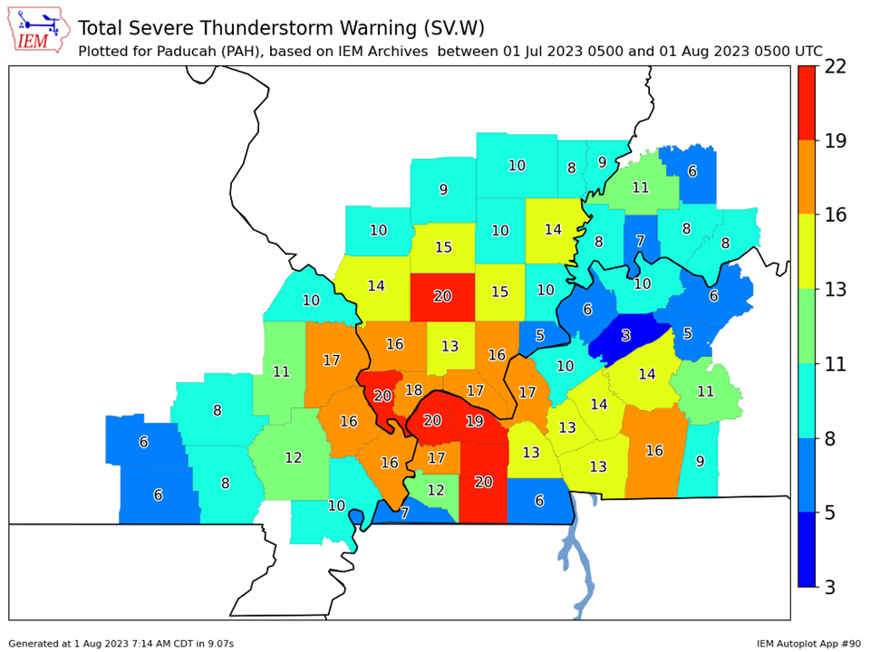
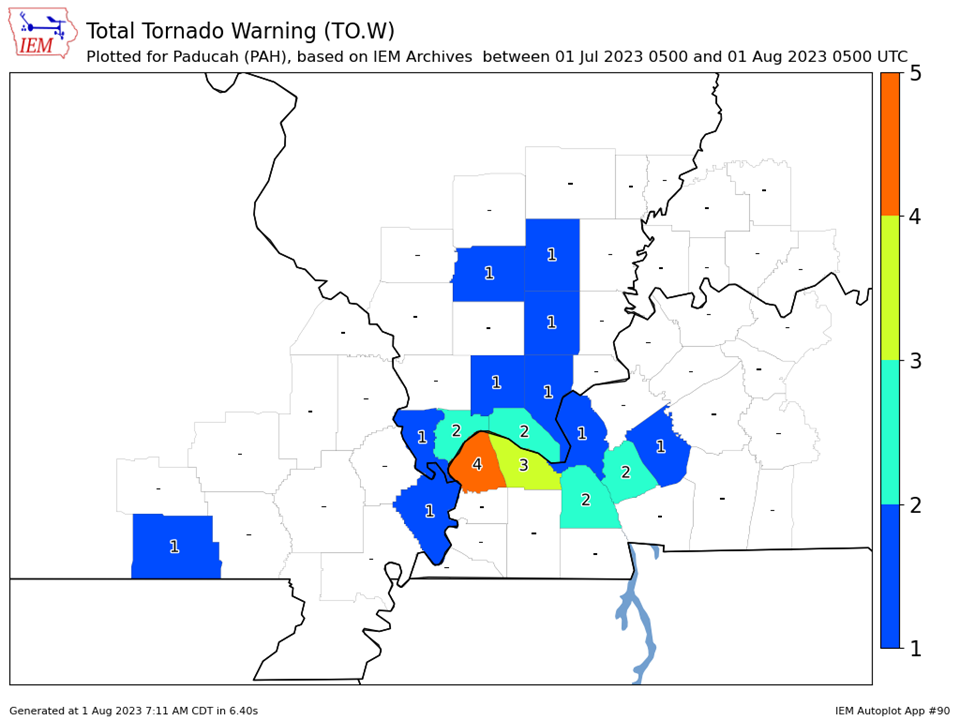
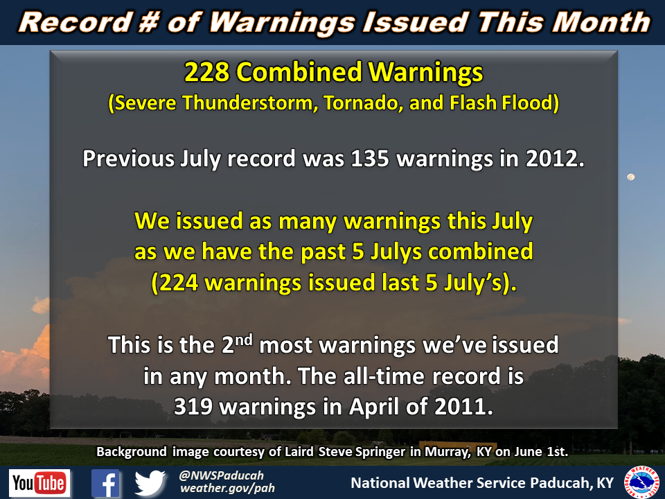
It was a very active month for severe thunderstorms across the region. Our office shattered the previous July record for most number of combined warnings (Severe Thunderstorm, Tornado, and Flash Flood). We ended up with 228 warnings this July, which was the 2nd most of any month on record (only behind April 2011). For comparison, a typical July will have around 41 warnings issued.
The graphic below shows radar estimated rainfall totals. This map will tend to be slightly more accurate than the one above in areas with little to no observation stations. Rainfall tends to vary quite drastically over small distances in the summer-time and we unfortunately don't have an observer set up every 2 miles for us.
| July 2023 Review: Precipitation and Temperature Maps (Click on image to enlarge) |
 |
| Climate Maps are from the Northeast Regional Climate Center |
Monthly Climate Report: Paducah | Evansville | Cape Girardeau | Poplar Bluff | Carbondale
| Severe Thunderstorm Warnings - County Based | Tornado Warnings - County Based |
 |
 |
| Flash Flood Warnings - County Based | Total # of Warnings Issued |
 |
 |