Overview
A moist and unstable airmass combined with a front bisecting through the area to produce strong to severe thunderstorms over the lower Ohio Valley during the afternoon and early evening on July 3rd. The most significant damage from the storms was around the Poseyville, IN area where a microburst occurred with winds up to 80 mph estimated. The water vapor content of the atmosphere was quite high, helping to produce very efficient rain-producing thunderstorms and flash flooding in some areas.
Tornadoes:
|
|
||||||||||
|
||||||||||
|
Tornado - Kirksey, KY
Track Map 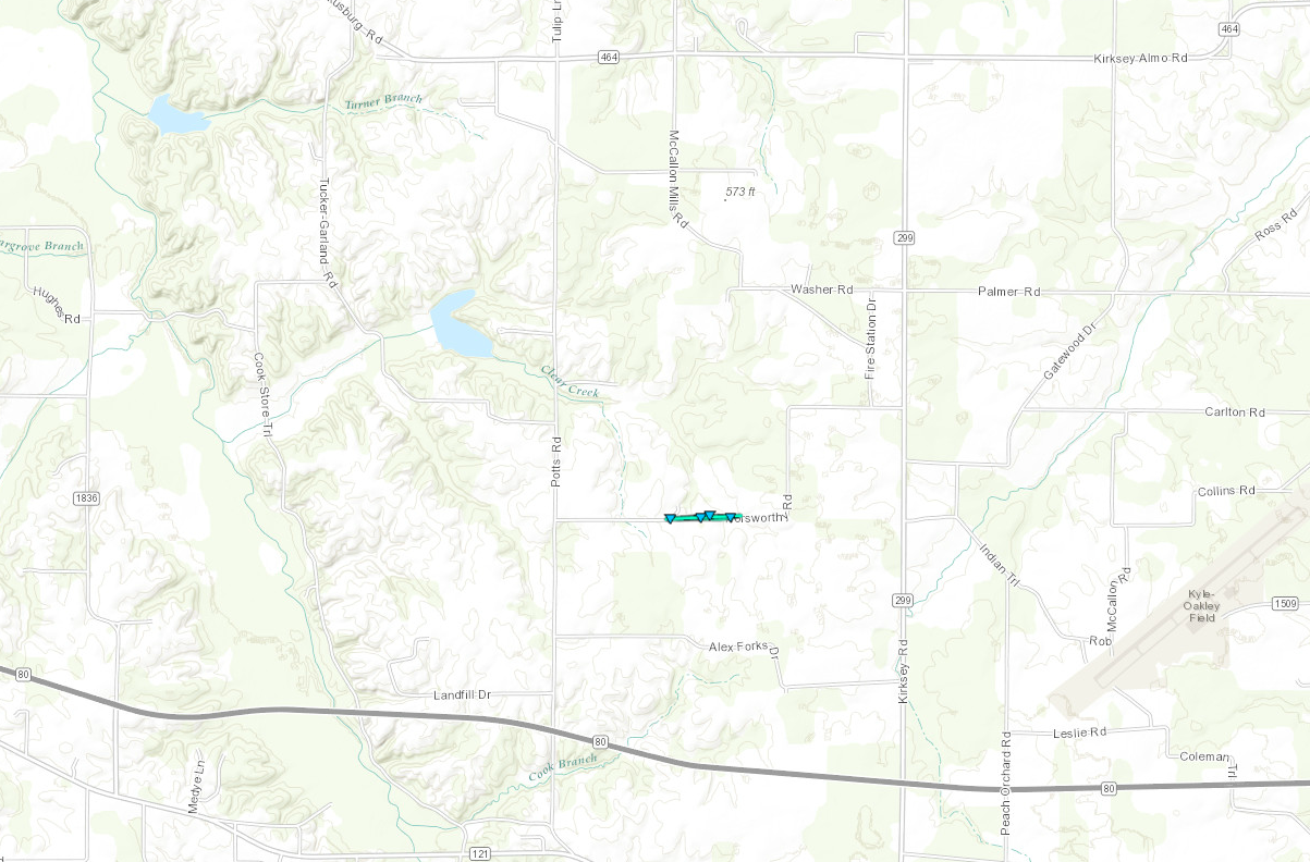 
|
||||||||||||||||
The Enhanced Fujita (EF) Scale classifies tornadoes into the following categories:
| EF0 Weak 65-85 mph |
EF1 Moderate 86-110 mph |
EF2 Significant 111-135 mph |
EF3 Severe 136-165 mph |
EF4 Extreme 166-200 mph |
EF5 Catastrophic 200+ mph |
 |
|||||
Wind:
...NWS DAMAGE SURVEY FOR 07/03/16 Microburst event for
Posey County Indiana...

Estimated peak wind:    80 mph
Path length /Statute/:  2 miles
Path width /Maximum/:   1200 yards
Fatalities:             0
Injuries:               0

Start date:             July 3 2016
Start time:             3:48 PM CDT
Start location:         1.25 miles west northwest of
                        Poseyville IN

End date:               July 3 2016
End time:               3:51 PM CDT
End location:           0.75 miles east of Poseyville IN

Summary: Dozens of tree limbs broken and trees, some large,
uprooted. Several houses with partial shingles loss. A few
houses with damage due to fallen trees. Some fencing
blown over.
 |
 |
 |
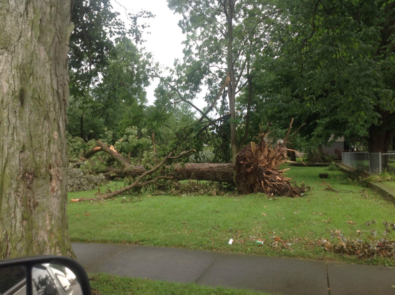 |
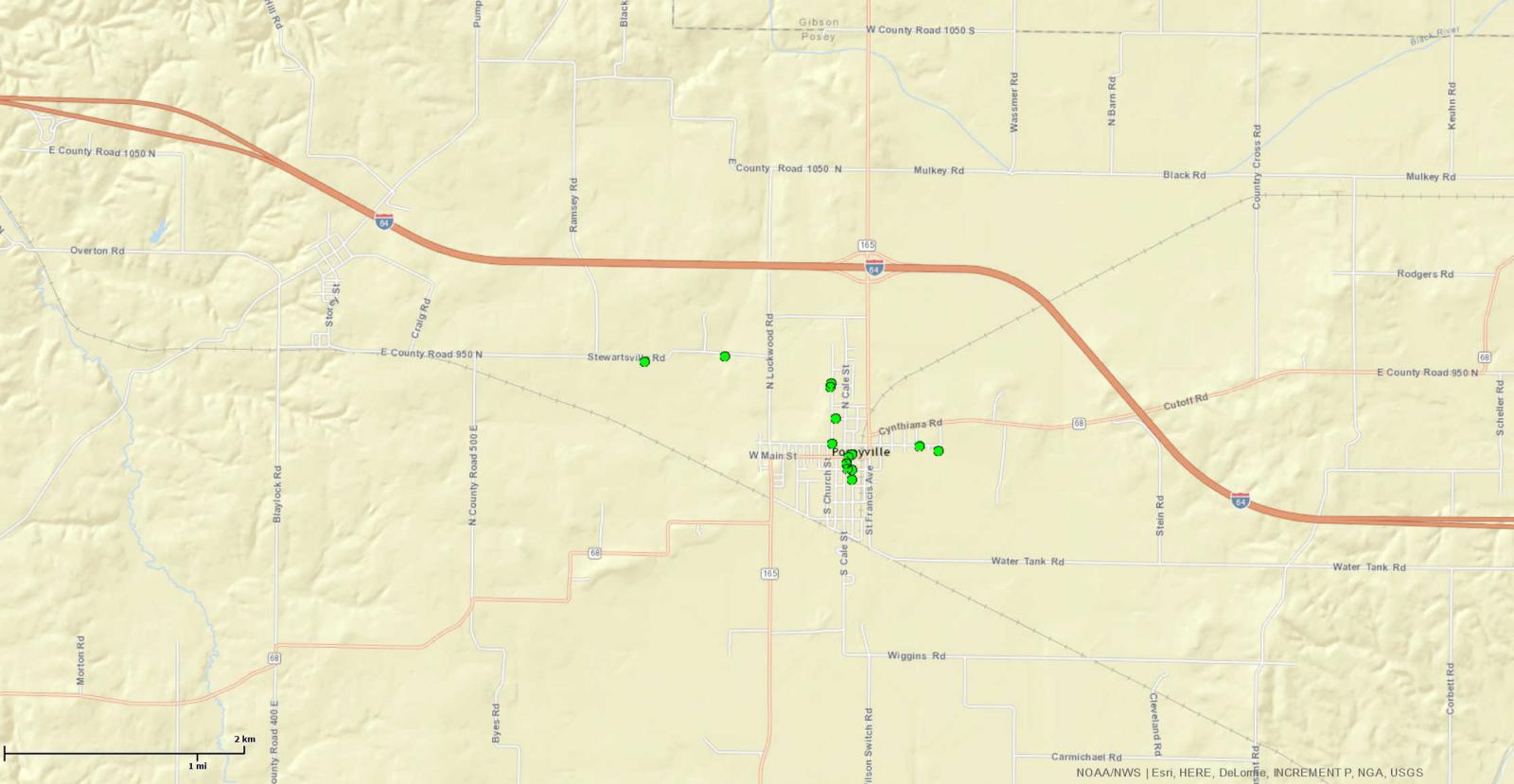
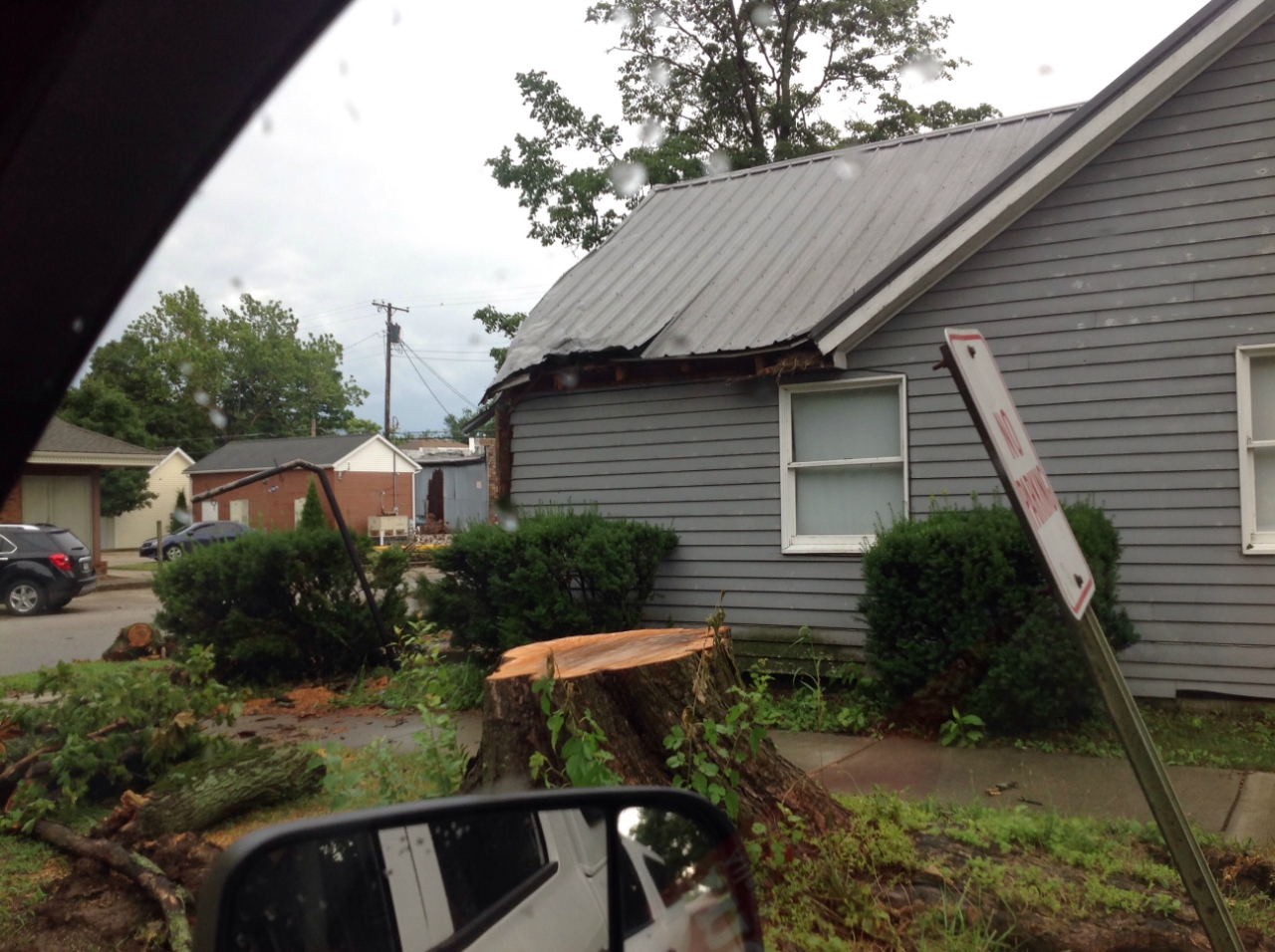
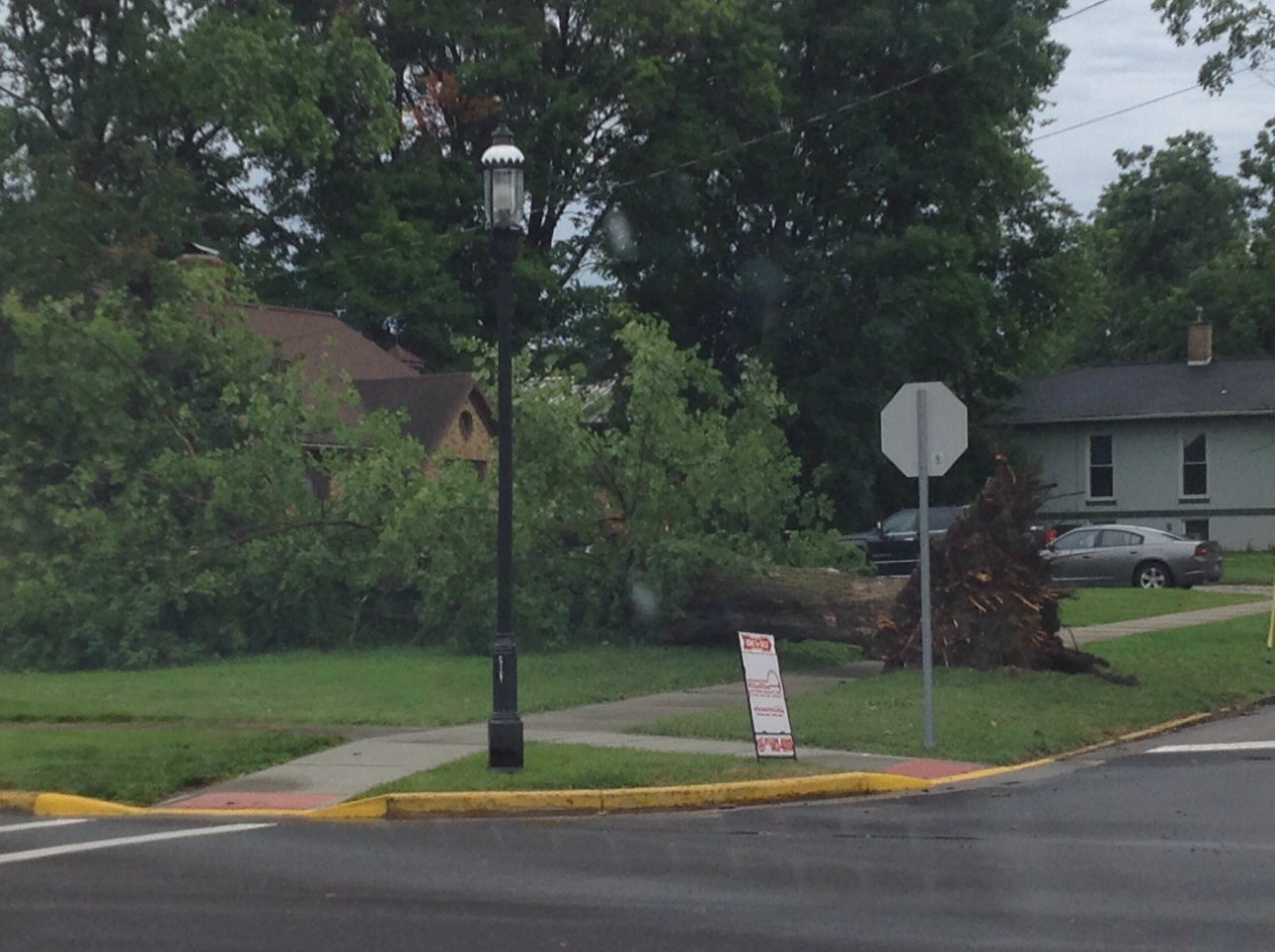
| Microburst track thru Poseyville, IN | Damage in Poseyville | Tree uprooted in Poseyville | Tree uprooted in Poseyville |
Above link shows an animated radar loop from 12:15pm to 11pm on Sunday July 3rd. Thunderstorm clusters/line segments moved across the area.
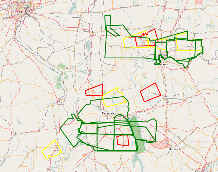
The image below shows the polygons of all the warnings issued, overlayed on top of each other.
(Click the image to enlarge it)
Storm Reports
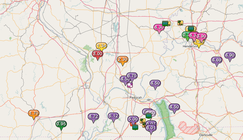
(The graphic below shows the storm reports from the event. Flash Flooding/heavy rain reports were the dominate hazard. -Click image to enlarge it)
..TIME...   ...EVENT...      ...CITY LOCATION...     ...LAT.LON...
..DATE...   ....MAG....      ..COUNTY LOCATION..ST.. ...SOURCE....
            ..REMARKS..
0250 PM     HAIL             3 NNE ROUND KNOB        37.26N 88.71W
07/03/2016  E0.75 INCH       MASSAC             IL   TRAINED SPOTTER

            DIME SIZED HAIL
0325 PM     TSTM WND GST     CARMI                   38.09N 88.17W
07/03/2016  E50 MPH          WHITE              IL   PUBLIC
0353 PM     TSTM WND DMG     POSEYVILLE              38.17N 87.78W
07/03/2016                   POSEY              IN   EMERGENCY MNGR

            SEVERAL TREES DOWN AND DAMAGE TO FENCES IN TOWN.
0445 PM     HEAVY RAIN       BERNIE                  36.67N 89.97W
07/03/2016  M0.95 INCH       STODDARD           MO   TRAINED SPOTTER

            15 MINUTE RAINFALL ACCUMULATION
0435 PM     HEAVY RAIN       6 NNW EVANSVILLE        38.06N 87.59W
07/03/2016  M1.00 INCH       VANDERBURGH        IN   TRAINED SPOTTER

            15 MINUTE RAINFALL ACCUMULATION
0416 PM     HEAVY RAIN       DE SOTO                 37.82N 89.23W
07/03/2016  M1.34 INCH       JACKSON            IL   TRAINED SPOTTER

            20 MINUTE RAINFALL ACCUMULATION
0505 PM     HEAVY RAIN       EVANSVILLE              37.98N 87.54W
07/03/2016  E1.24 INCH       VANDERBURGH        IN   TRAINED SPOTTER

            RAINFALL ESTIMATED BETWEEN 1 AND 1.24 INCHES WITHIN 15
            MINUTES ON SOUTHEAST SIDE OF EVANSVILLE
0527 PM     HEAVY RAIN       SPOTTSVILLE             37.88N 87.44W
07/03/2016  M1.25 INCH       HENDERSON          KY   TRAINED SPOTTER

            22 MINUTE RAINFALL ACCUMULATION
0520 PM     HEAVY RAIN       NEWBURGH                37.95N 87.40W
07/03/2016  M0.84 INCH       WARRICK            IN   TRAINED SPOTTER

            20 MINUTE RAINFALL ACCUMULATION
0615 PM     FUNNEL CLOUD     3 S MAYFIELD            36.69N 88.65W
07/03/2016                   GRAVES             KY   LAW ENFORCEMENT

            REPORTED BY LAW ENFORCEMENT.
0315 PM     TSTM WND DMG     CARMI                   38.09N 88.17W
07/03/2016                   WHITE              IL   TRAINED SPOTTER

            LATE REPORT. 20FT TALL TREE WITH 2FT DIAMETER UPROOTED.
            LARGER PINE TREE SNAPPED.
0315 PM     TSTM WND DMG     3 E CROSSVILLE          38.16N 88.01W
07/03/2016                   WHITE              IL   TRAINED SPOTTER

            LATE REPORT. 20FT TALL TREE WITH 2FT DIAMETER UPROOTED.
            LARGER PINE TREE SNAPPED.
0655 PM     FUNNEL CLOUD     ALMO                    36.69N 88.28W
07/03/2016                   CALLOWAY           KY   TRAINED SPOTTER

            FUNNEL CLOUD REPORTED WITH STRONG ROTATION.
0700 PM     FUNNEL CLOUD     5 N MURRAY              36.68N 88.32W
07/03/2016                   CALLOWAY           KY   TRAINED SPOTTER

            FUNNEL CLOUD REPORTED ALONG WITH LARGE WALL CLOUD.
0655 PM     TSTM WND GST     MURRAY                  36.61N 88.32W
07/03/2016  M52 MPH          CALLOWAY           KY   AWOS
0721 PM     TSTM WND DMG     12 NW MURRAY            36.73N 88.47W
07/03/2016                   CALLOWAY           KY   EMERGENCY MNGR

            TREE ACROSS AIRPORT ROAD AND INTO NEARBY POWER LINES AT
            TUCKER ROAD.
0723 PM     FLOOD            EVANSVILLE              37.98N 87.54W
07/03/2016                   VANDERBURGH        IN   EMERGENCY MNGR

            FLOODING CONDITIONS REPORTED ALONG FULTON AVENUE NORTH OF
            COLUMBIA STREET
0737 PM     FLOOD            EVANSVILLE              37.98N 87.54W
07/03/2016                   VANDERBURGH        IN   EMERGENCY MNGR

            PORTIONS OF RAY BECKER PARKWAY FLOODING WITH ONE STALLED
            VEHICLE.
0700 PM     HEAVY RAIN       6 W EVANSVILLE          37.98N 87.65W
07/03/2016  M0.70 INCH       VANDERBURGH        IN   TRAINED SPOTTER

            20 MINUTE RAINFALL ACCUMULATION
0854 PM     HEAVY RAIN       CREAL SPRINGS           37.62N 88.84W
07/03/2016  M2.30 INCH       WILLIAMSON         IL   FIRE DEPT/RESCUE

            4 HOUR RAINFALL ACCUMULATION
1035 PM     HEAVY RAIN       4 N MURRAY              36.67N 88.32W
07/03/2016  M2.53 INCH       CALLOWAY           KY   EMERGENCY MNGR

            RAINFALL RATES ARE 1 TO 3 INCHES PER HOUR. 911 CENTER
            RECEIVED CALL REQUESTING ASSISTANCE AT PARADISE RESORT
            WHERE A CABIN HAS STANDING WATER INSIDE.
1135 PM     FLASH FLOOD      MURRAY                  36.61N 88.32W
07/03/2016                   CALLOWAY           KY   EMERGENCY MNGR

            EMERGENCY MANAGER REPORTS FLASH FLOODING IN THE
            COMMUNITY. SEVERAL STREETS WITH 2 FEET OF WATER. WATER
            MOVING INTO SOME HOMES, EVACUATIONS POSSIBLE.
1135 PM     HEAVY RAIN       4 N MURRAY              36.67N 88.32W
07/03/2016  M3.69 INCH       CALLOWAY           KY   EMERGENCY MNGR

            EVENING RAINFALL ACCUMULATION SO FAR
Environment
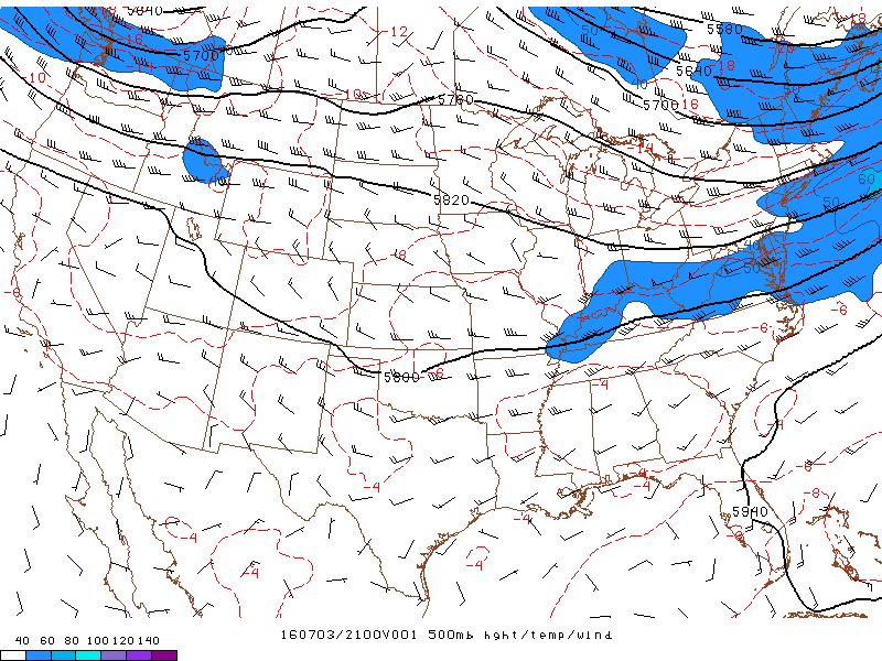
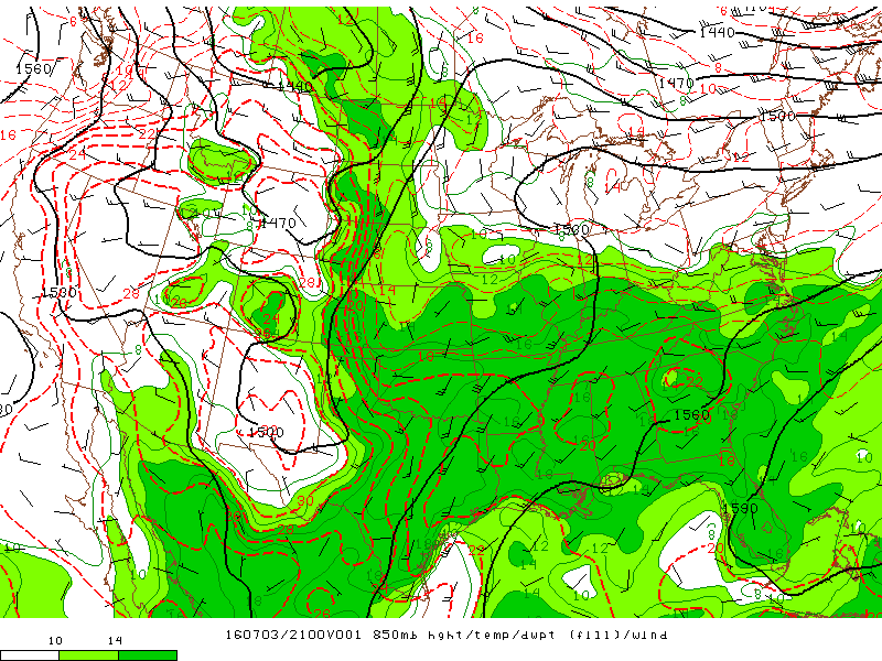
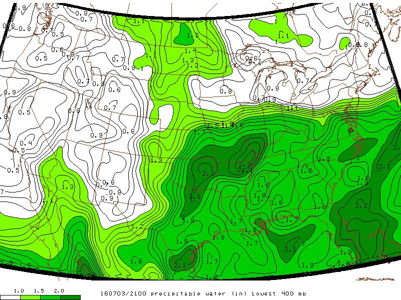
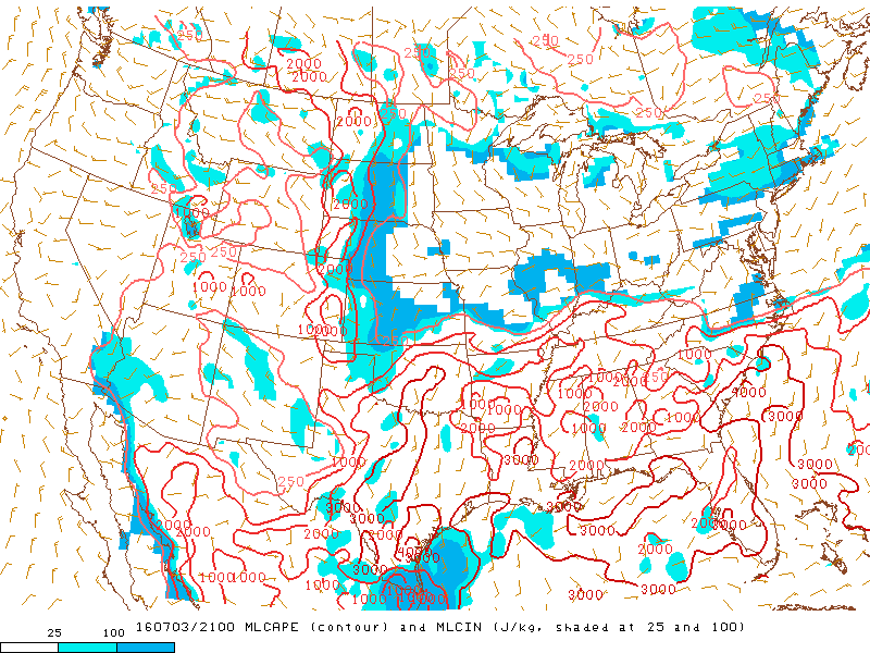
Thunderstorms ignited along a frontal boundary draped over the region. The surface temperature map shows the nice thermal gradient associated with the front, with low to mid 60s in central IL and near 90 along the KY/TN border. A 500mb shortwave trough was located over the Central Plains with a weaker ripple in the flow located over western KY during the late afternoon. Mid level flow was enhanced with winds over 40 kts at 500mb. This helped sustain organized convection over our area. Precipitable water values were quite high, even by July standards, with values up to 2.3 inches! This resulted in thunderstorms being very efficient rainfall producers and thus flash flooding being an impact. Images below are from the NOAA/NWS Storm Prediction Center.
 |
 |
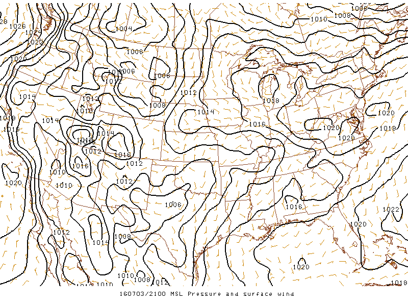 |
| 500 mb at 4 PM CDT | 850 mb at 4 PM CDT | Mean Sea Level Pressure at 4 PM CDT |
Moisture and instability summary...
 |
 |
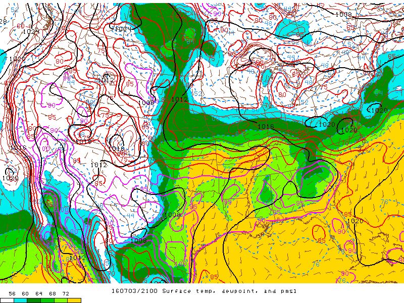 |
| Precip Water at 4 PM CDT | MLCAPE at 4 PM CDT | SFC Temps/Dewpoints at 4 PM CDT |
 |
Media use of NWS Web News Stories is encouraged! Please acknowledge the NWS as the source of any news information accessed from this site. |
|

