Overview
|
Multiple rounds of very heavy rain associated with thunderstorm complexes and training thunderstorms moved across our region from the afternoon of June 25th through the morning of June 28th. Rainfall totals of 3 to 12" were observed which resulted in considerable to major flash flooding in many communities including Evansville (IN), Owensboro (KY), Paducah (KY), and Cape Girardeau (MO). The highest amounts of 10 to 12" were primarily focused across Gibson and Pike counties in southwest Indiana. This amount of rain in a 72 hour period has a return interval of about 200 years. Evansville registered 7.80" in a 4 day period, which was their greatest 4-day rainfall since 1996. Pike County, Indiana set a new 3 day rainfall record with 10.85" (COOP site 6 NW of Holland), surpassing the previous record for the county which was 10.12". Daviess County also set a new rainfall record for a 24 hour period, with a site 5 miles south of Owensboro receiving 6.20", breaking the previous highest 1 day rainfall for the county which was 5.50". |
Rain Reports
Extremely heavy rainfall totals ranging from 3 to 12" were observed across our region during this 3 day period. Nearly everywhere in our 58 county area received at least 1 to 2" of rain. Swaths of higher amounts were focused from around Cape Girardeau Missouri into extreme southern Illinois and southeast into Paducah, KY which received 3 to 5". Even higher amounts were focused across much of southwest Indiana and far northwest Kentucky around Owensboro and a small area of southeast Illinois around Mount Carmel. This area received widespread 4 to 8", along with a swath of higher amounts up to 10 to 12" mainly focused across parts of Gibson and Pike counties in Indiana. Rainfall rates were extremely high with 1" falling in as little as 15 to 20 minutes and 2" within 30 to 45 minutes in some cases.
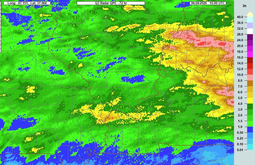 |
| MRMS rainfall estimates for the 72 hour period ending at 10 AM June 28th |
Below are snapshots of observed rainfall amounts from the CoCoRaHS network. The image on the left shows totals in southwest Indiana and northwest Kentucky and the image on the right has totals for far southern Illinois, the Jackson Purchase area of west Kentucky, and portions of southeast Missouri near the Mississippi River.
 |
 |
| 72 hour rainfall totals from CoCoRaHS Network | 72 hour rainfall totals from CoCoRaHS Network |
Flooding
Streets turned into rivers in many communities due to repeated rounds of thunderstorms, each producing very high rainfall rates. Numerous water rescues occurred across our area and there were countless roads that were impassable for periods of time due to water over them. Several roads washed out due to the amount of water. Also, several rivers experienced flooding including the Patoka River which jumped above major flood stage in Princeton after 3 to 12" of rain across the basin.
 |
 |
 |
| Hydrograph for Patoka River at Princeton, IN | Hydrograph for Patoka River at Winslow, IN | Hydrograph for Wabash River at New Harmony, IN |
Radar
Here is a radar loop from the entire event starting at 1 PM on June 25th and ending at 8 AM on June 28th. Below is a map showing the number of Flash Flood warnings issued for each of our counties. We issued numerous Flash Flood Warnings with the considerable tag and 1 Flash Flood Emergency (Pike and Eastern Gibson Counties).
 |
| Number of Flash Flood Warnings issued in each county during this event |
Photos
 |
 |
 |
|
| Flooding in Cape Girardeau, MO via Grant Dade | Flooding on North Henderson in Cape Girardeau, MO via Jeff Crites | Flooding in Evansville, IN on Claremont Ave. via Evansville Watch | Flooding in Paducah, KY near Pecan and Buckner via Beau Dodson |
 |
 |
 |
 |
| Flooding in Paducah near Buckner and Oakcrest via Steve Kyle | Flooding in Lone Oak along Palisades Circle via Beau Dodson | Washed out road in McCracken County KY courtesy of Beau Dodson | Flooding in Oakland City, IN via Tammy Vinnedge |
Environment
Precipitable water values were extremely high, on the order of 2.2 to 2.3" for an extended period from the afternoon of the 26th through early morning on the 28th (essentially a 36 hour period). Multiple ripples in the mid level flow combined with a surface boundary in place to produce several rounds of thunderstorms that produced very efficient rainfall rates.
 |
 |
 |
| Precipitable Water Values at 4 PM June 26 | Precipitable Water Values at 9 AM June 27 | Precipitable Water Values at 4 PM June 27 |
Additional Information
We issued a Flash Flood Watch for the northwest half of the region during the early morning of the 25th. 24 hours later we expanded the Flood Watch to encompass the entire Quad State region and also ramped up the messaging to highlight that some of the flash flooding could be considerable to major. The worst of the flash flooding occurred from the afternoon of the 26th through early morning on the 28th.
 |
 |
| Weather Story issued at 2 AM on June 25th | Weather Story issued at 8 AM on June 26th |
 |
Media use of NWS Web News Stories is encouraged! Please acknowledge the NWS as the source of any news information accessed from this site. |
|


