Overview
Hot and humid conditions developed during the afternoon on June 25th ahead of a dryline moving southeast across Illinois and Missouri. This provided fuel for thunderstorms, which developed by mid afternoon across the Wabash River Valley and tracked into southwest Indiana and northwest Kentucky. Additional storms developed during the evening hours and moved across west Kentucky and southern portions of southeast Missouri. The environment was ideal for large hail development and some hail stones of golf ball to tennis ball sized was reported, particularly across Webster and Daviess Counties in Kentucky. A few areas observed significant wind from the storms as well, most notably near Wingo and Elkton, KY. The KY mesonet station southwest of Elkton reported a 95 mph wind gust shortly before midnight as the final round of storms moved through.Photos
 |
 |
 |
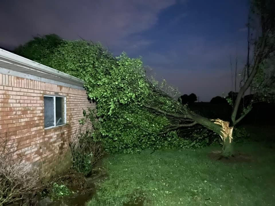 |
| Large Hail in Clay, KY (Webster County) via Sara Payton | Large Hail in Masonville, KY via Shannon Webb Leonard | Large Hail in Wheatcroft, KY (Webster County) via Monica-Henry Acker | Wind damage in Wingo, KY courtesy of Austin Lamb |
Radar
Click here for a radar loop of this event. Scattered thunderstorms developed around 3 PM across southeast Illinois and intensified as they moved eastward into southwest Indiana and northwest Kentucky. These storms would dissipate around 5:30 PM. Then around 7 PM, additional development occurred in 2 separate areas. One focused across southwest Indiana and the other in southeast Missouri near the Arkansas border. Yet another cluster of storms developed around 10 PM near the Ohio River in west Kentucky and progressed across the central and southern Pennyrile region before exiting our southeast counties around midnight.
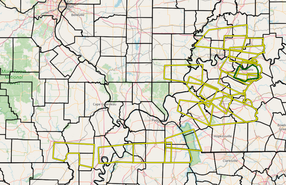 |
| Map showing all Severe Thunderstorm Warning polygons issued during this event. |
Storm Reports
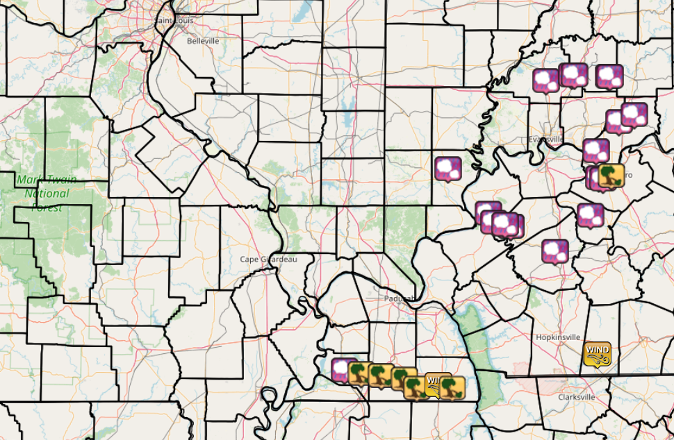 |
| Storm Reports from across the region. (Purple icon with cloud - Large Hail, Yellow Icon with Tree - Wind Damage) |
Preliminary Local Storm Report...Summary
National Weather Service Paducah KY
1248 AM CDT Mon Jun 26 2023

..TIME...   ...EVENT...      ...CITY LOCATION...     ...LAT.LON...
..DATE...   ....MAG....      ..COUNTY LOCATION..ST.. ...SOURCE....
            ..REMARKS..
1140 PM     Tstm Wnd Dmg     4 NE Trenton            36.76N 87.22W
06/25/2023                   Todd               KY   Emergency Mngr

            Roof torn off pole barn, minor shingle
            damage to home, and trees down on farm along
            Gun Club Road 3.5 mile north of Trenton.
            Very close to the observed 95 mph wind gust
            from the mesonet.

1140 PM     Tstm Wnd Gst     4 NE Trenton            36.76N 87.21W
06/25/2023  M95 MPH          Todd               KY   Mesonet

            Todd County Mesonet located 5 miles
            southwest of Elkton.

0920 PM     Tstm Wnd Dmg     3 NNE Bell City         36.57N 88.48W
06/25/2023                   Calloway           KY   Public

            Tree blocking Swan Road.

0920 PM     Tstm Wnd Gst     2 SSW Murray            36.59N 88.33W
06/25/2023  E60 MPH          Calloway           KY   Trained Spotter


0910 PM     Tstm Wnd Dmg     2 SE Sedalia            36.62N 88.57W
06/25/2023                   Graves             KY   Public

            Trees down on Dr Melvin Rd off of KY 97.
0900 PM     Hail             Wingo                   36.64N 88.74W
06/25/2023  E1.75 inch       Graves             KY   Public

            Late report. Golf ball sized hail in Wingo
            area.

0900 PM     Tstm Wnd Dmg     Wingo                   36.64N 88.73W
06/25/2023                   Graves             KY   Public

            Late report. Winds estimated at 70+ mph.
            Massive trees uprooted. Garage taken off
            foundation, wooden play house picked up and
            thrown, shingles ripped off. Also, a jeep
            was moved 40 feet and pushed into a fence.
0900 PM     Tstm Wnd Dmg     Wingo                   36.64N 88.73W
06/25/2023                   Graves             KY   Public

            Numerous trees down in neighborhood along
            Stubblefield Road. Late report.

0900 PM     Tstm Wnd Dmg     1 SE Wingo              36.64N 88.73W
06/25/2023                   Graves             KY   Trained Spotter

            Tree down across County Road 129, about 3/4
            mile south of Hwy 339 near Wingo. Multiple
            trees and power poles snapped in the Wingo
            area.

0856 PM     Tstm Wnd Dmg     1 ESE Owensboro         37.76N 87.11W
06/25/2023                   Daviess            KY   Emergency Mngr

            Numerous trees down from Stanley to
            Owensboro and across much of the rest of the
            county. Very large hail, at least 2 inches
            in diameter reported in several areas. Fire
            crews investigating additional
            damage/reports in the southern part of the
            county near Whitesville and Masonville.

0851 PM     Tstm Wnd Dmg     6 NE Crutchfield        36.65N 88.87W
06/25/2023                   Hickman            KY   Emergency Mngr

            KY 307 blocked south of KY-58 due to
            numerous trees down.

0845 PM     Hail             Clinton                 36.67N 88.99W
06/25/2023  M1.25 inch       Hickman            KY   Trained Spotter


0845 PM     Hail             3 WSW Owensboro         37.74N 87.17W
06/25/2023  M2.00 inch       Daviess            KY   Emergency Mngr

            2 inch diameter hail at Owensboro Airport.

0840 PM     Hail             4 W Owensboro           37.75N 87.20W
06/25/2023  M1.50 inch       Daviess            KY   Trained Spotter

            Half dollar to ping pong sized hail near
            Sorgho Elementary school west of Owensboro.

0825 PM     Hail             9 W Rockport            37.90N 87.22W
06/25/2023  M1.00 inch       Spencer            IN   Emergency Mngr

            Report of nickel to quarter sized hail in
            town of Hatfield.

0730 PM     Hail             2 SW Santa Claus        38.10N 86.95W
06/25/2023  M0.70 inch       Spencer            IN   Emergency Mngr

            Dime sized hail.

0500 PM     Hail             Madisonville            37.34N 87.51W
06/25/2023  M1.75 inch       Hopkins            KY   Trained Spotter

            Hail ranging from quarter to golf ball
            sized.

0454 PM     Hail             Calhoun                 37.54N 87.26W
06/25/2023  E1.25 inch       McLean             KY   Public


0439 PM     Hail             3 NNW Chrisney          38.06N 87.06W
06/25/2023  E1.00 inch       Spencer            IN   Public

            Report from mPING: Quarter (1.00 in.).

0426 PM     Hail             Wheatcroft              37.49N 87.86W
06/25/2023  E1.50 inch       Webster            KY   Emergency Mngr


0424 PM     Hail             Clay                    37.48N 87.82W
06/25/2023  E2.50 inch       Webster            KY   Public


0424 PM     Hail             Clay                    37.48N 87.82W
06/25/2023  E2.25 inch       Webster            KY   Public


0420 PM     Hail             7 SE Winslow            38.31N 87.12W
06/25/2023  M1.50 inch       Pike               IN   Cocorahs


0419 PM     Hail             7 SE Winslow            38.31N 87.13W
06/25/2023  M1.25 inch       Pike               IN   Public


0417 PM     Hail             4 SE Sturgis            37.50N 87.94W
06/25/2023  E1.25 inch       Union              KY   Trained Spotter


0413 PM     Hail             Sturgis                 37.55N 87.98W
06/25/2023  E1.25 inch       Union              KY   Trained Spotter


0405 PM     Hail             2 SW Oakland City       38.32N 87.37W
06/25/2023  M1.75 inch       Gibson             IN   Public

            Report relayed via Facebook.

0405 PM     Hail             3 WSW Oakland City      38.32N 87.39W
06/25/2023  E1.00 inch       Gibson             IN   Public

            Report from mPING: Quarter (1.00 in.).

0352 PM     Hail             3 N Fort Branch         38.29N 87.57W
06/25/2023  E1.75 inch       Gibson             IN   Trained Spotter

            Hail ranged from quarters to golf ball
            sized. Driving by the Toyota Plant south of
            Princeton Indiana.

0335 PM     Hail             Ridgway                 37.80N 88.26W
06/25/2023  M0.88 inch       Gallatin           IL   Public

            Nickel sized hail.
Heat and Humidity
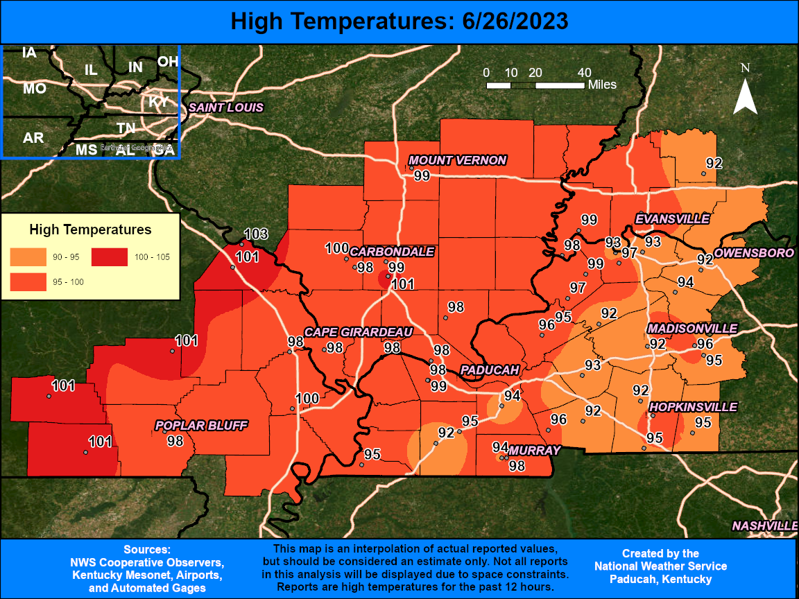
Very hot and humid conditions developed Sunday afternoon ahead of a dryline progressing southeast across Illinois and Missouri. Temperatures soared into the mid 90s to around 100 degrees. Combined with the high humidity heat index readings were between 105 and 110 degrees. Localized higher readings up to 114 were observed. This provided a very unstable environment for thunderstorms during the late afternoon and evening. (Click images to enlarge)
 |
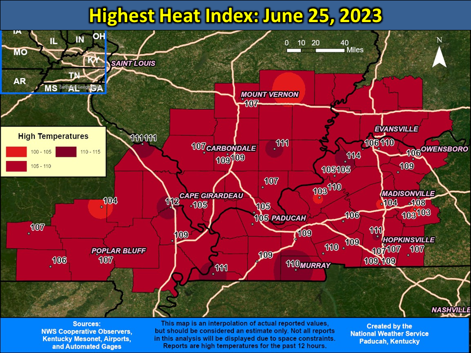 |
| Observed High Temperatures on June 25th | Peak Heat Index Readings on June 25th |
...MAXIMUM HEAT INDEX REPORTS FOR SUNDAY JUNE 25TH...

Location                     Heat Idx. Time/Date       Provider
Morganfield KY 4 E           114 F     0140 PM 06/25   KYMN2
Murray KY                    114 F     0115 PM 06/25   AWOS
Cape Girardeau MO            112 F     1153 AM 06/25   ASOS
Hickman KY 2 E               111 F     0235 PM 06/25   KYMN2
Harrisburg IL                111 F     0235 PM 06/25   AWOS
Perryville MO                111 F     1255 PM 06/25   AWOS
Hopkinsville KY 6 N          111 F     0125 PM 06/25   KYMN2
Henderson KY 5 E             110 F     0135 PM 06/25   KYMN2
Golden Pond KY               110 F     0121 PM 06/25   RAWS
Murray KY 1 W                110 F     0125 PM 06/25   KYMN2
Marion KY 4 NE               110 F     0200 PM 06/25   KYMN2
Cadiz KY 4 SW                109 F     0155 PM 06/25   KYMN2
Crab Orchard IL              109 F     1255 PM 06/25   RAWS
Benton KY 4 N                109 F     0225 PM 06/25   KYMN2
Fort Campbell KY             109 F     0155 PM 06/25   AWOS
Marion IL                    109 F     0345 PM 06/25   AWOS
Sikeston MO                  109 F     0135 PM 06/25   AWOS
Mayfield KY 6 SW             109 F     0125 PM 06/25   KYMN2
Calhoun KY 5 NW              109 F     0340 PM 06/25   KYMN2
Greenville KY                108 F     0255 PM 06/25   RAWS
Chicopee MO                  107 F     0222 PM 06/25   RAWS
Dixon Springs IL             107 F     1208 PM 06/25   RAWS
Madisonville KY              107 F     0335 PM 06/25   AWOS
Evansville IN                107 F     0254 PM 06/25   ASOS
2 E Hopkinsville KY          107 F     0155 PM 06/25   AWOS
Carbondale IL                107 F     1252 PM 06/25   ASOS
Mt Vernon IL                 107 F     1256 PM 06/25   AWOS
Poplar Bluff MO              107 F     0353 PM 06/25   ASOS
Elkton KY 5 SW               107 F     0255 PM 06/25   KYMN2
Greenville KY 6 N            106 F     0310 PM 06/25   KYMN2
Doniphan MO                  106 F     1053 AM 06/25   RAWS
Henderson KY                 106 F     0156 PM 06/25   AWOS
Owensboro KY                 106 F     0256 PM 06/25   AWOS
Princeton KY 2 SE            106 F     0235 PM 06/25   KYMN2
Bean Ridge IL                105 F     0257 PM 06/25   RAWS
Mayfield KY                  105 F     0235 PM 06/25   AWOS
Metropolis IL                105 F     0155 PM 06/25   AWOS
Paducah KY                   105 F     0553 PM 06/25   ASOS
2 E Sturgis KY               105 F     0115 PM 06/25   AWOS
Madisonville KY 4 S          104 F     1125 AM 06/25   KYMN2
Piedmont MO                  104 F     0430 PM 06/25   RAWS
Fairfield IL                 103 F     0135 PM 06/25   AWOS
1 W Marion KY                103 F     1255 PM 06/25   AWOS
Greenville KY                103 F     0255 PM 06/25   AWOS
 |
Media use of NWS Web News Stories is encouraged! Please acknowledge the NWS as the source of any news information accessed from this site. |
|

