Overview
|
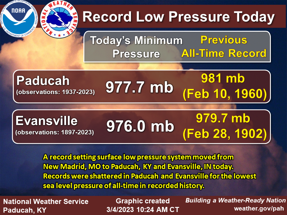
A strong storm system led to significant impacts across our region on March 3, 2023. Heavy rainfall amounts of 3 to 4.5 inches produced widespread flash flooding with numerous road closures. Very strong winds occurred, ranging between 50 and 70 mph. These were associated with both thunderstorms and gradient winds afterwards. The line of storms moved through during the late morning and midday time period, and then very strong winds continued for hours afterwards through the afternoon. NWS Paducah issued a rare High Wind Warning to account for the strong winds that persisted for hours. The magnitude and duration of this wind produced significant damage to trees, power lines, homes, etc. Soggy ground due to the excessive rainfall likely contributed to some trees being more susceptible to being blown over. Numerous power outages occurred, particularly across western Kentucky. 8 tornadoes occurred along the line of thunderstorms across west Kentucky and southwest Indiana. This included an EF-2 tornado that occurred just south of Paducah, KY shortly after 11 AM. Finally, the lowest barometic pressure of all-time was observed in Paducah (977.7 mb) and Evansville, IN (976.0 mb). |
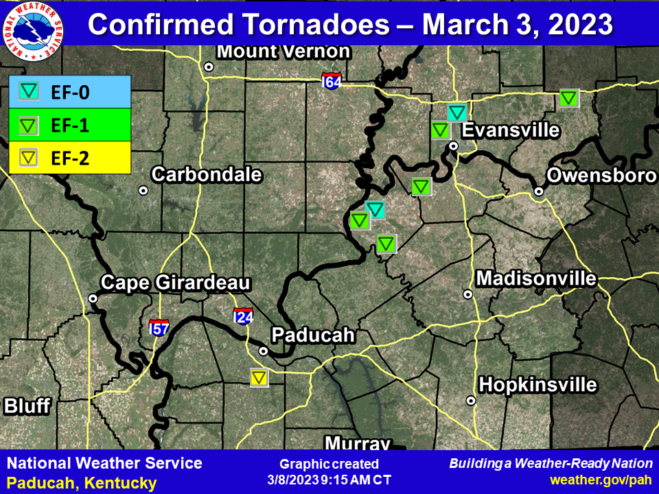 Map of the 8 tornadoes that touched down |
Tornadoes:
|
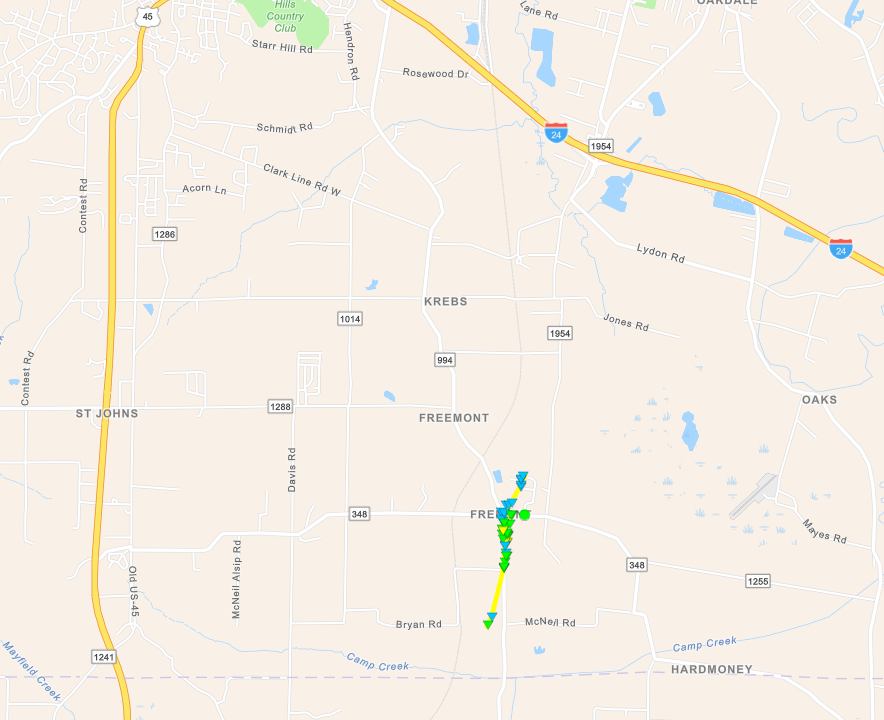
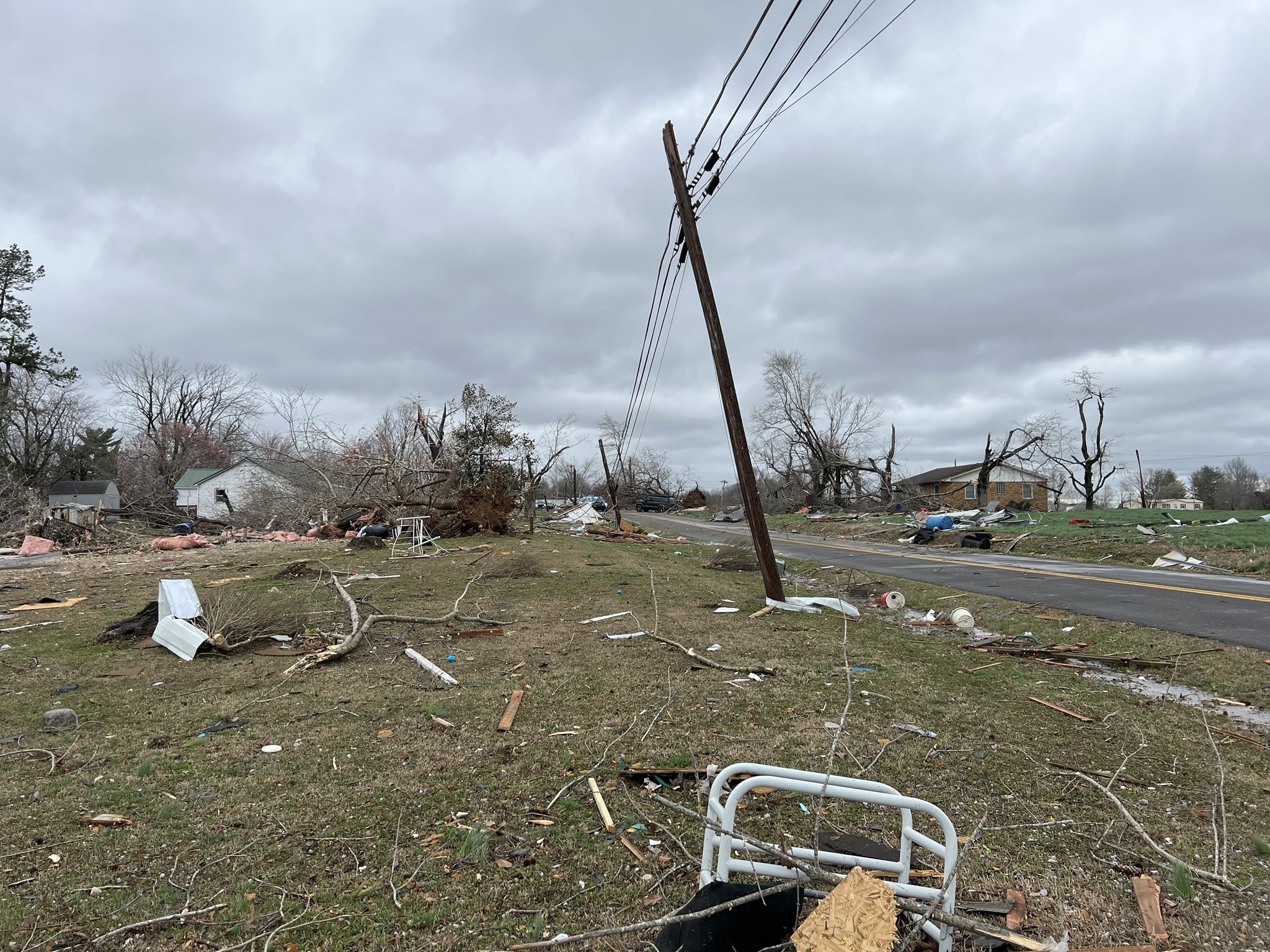
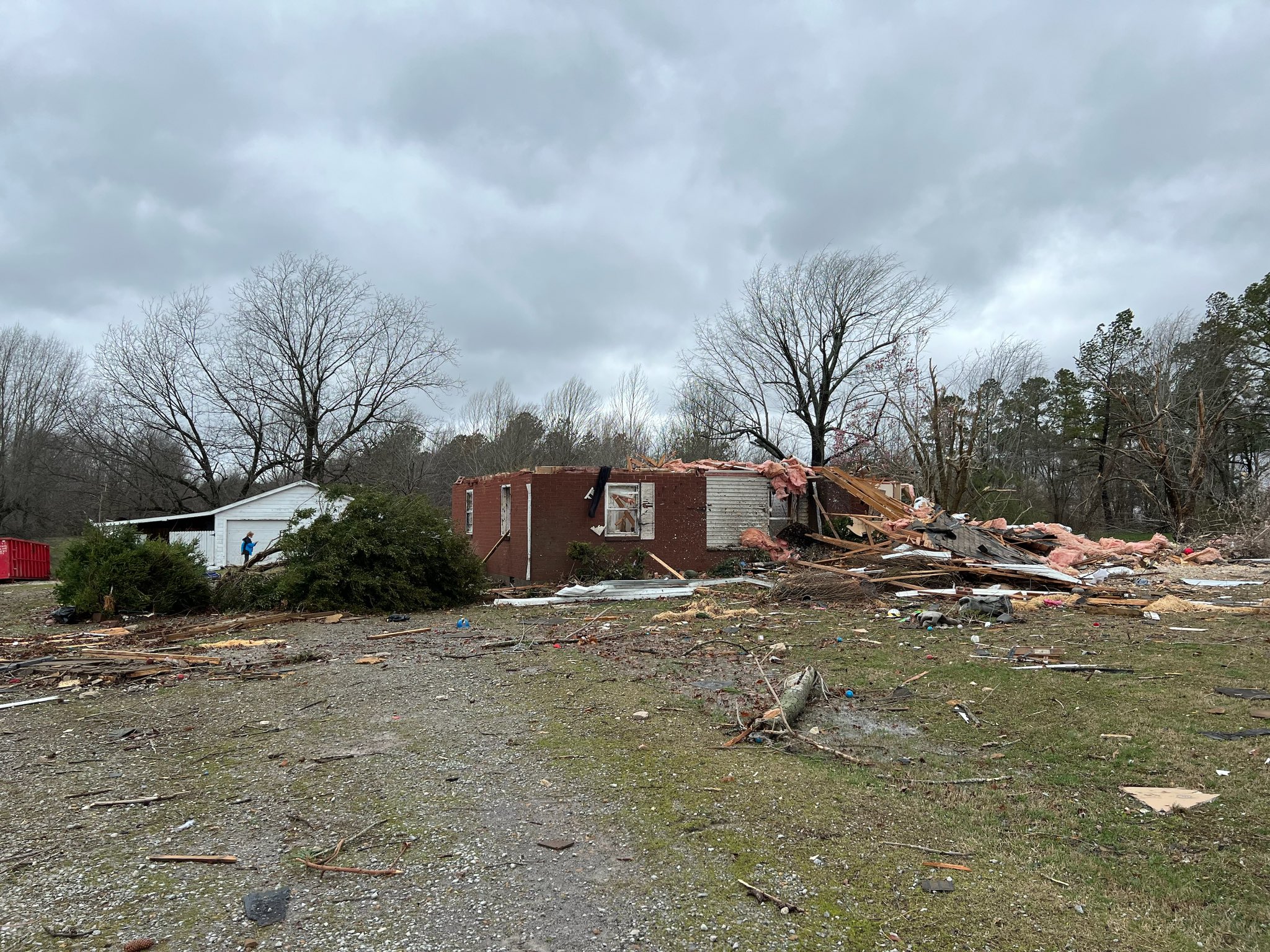
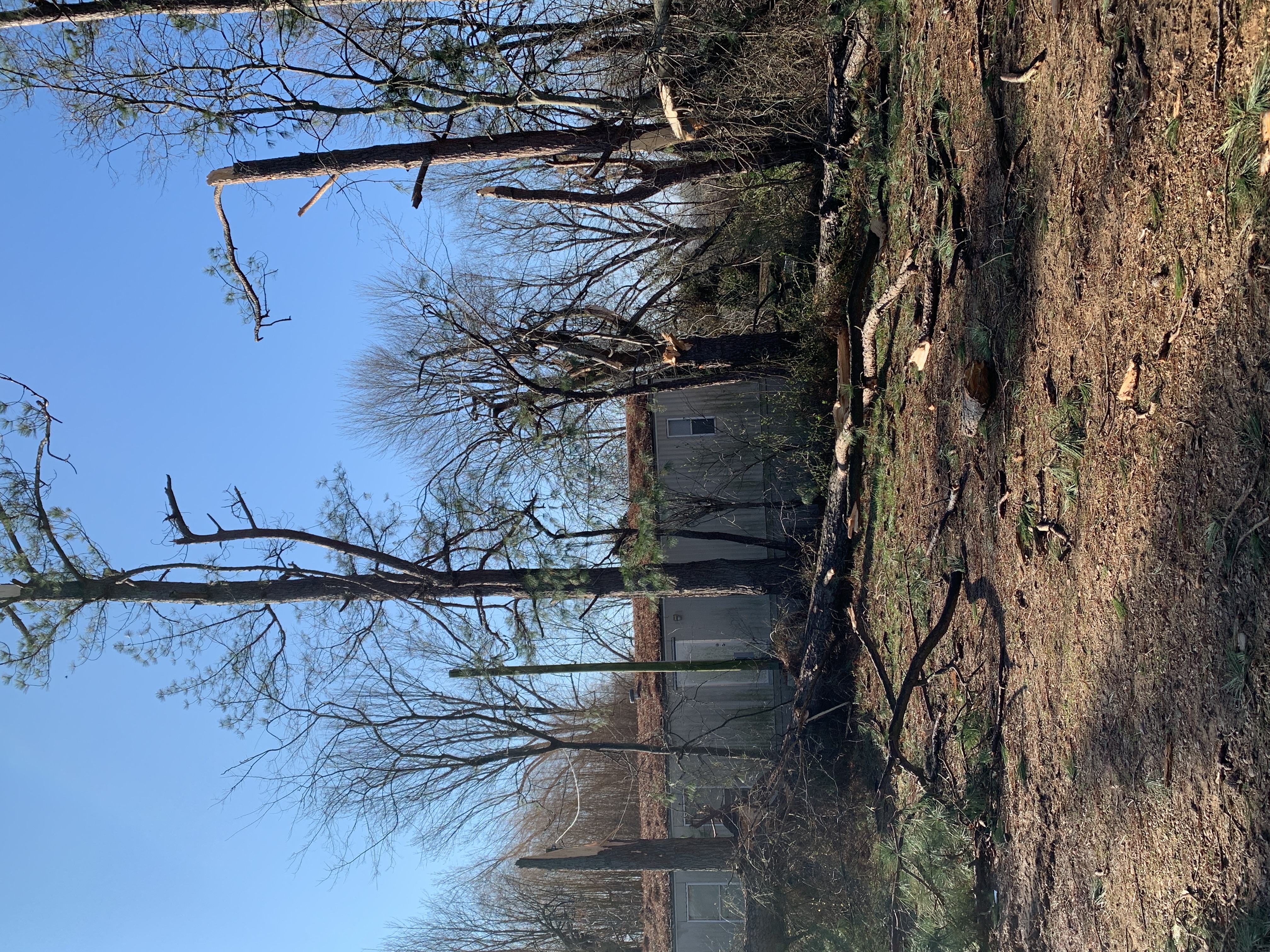
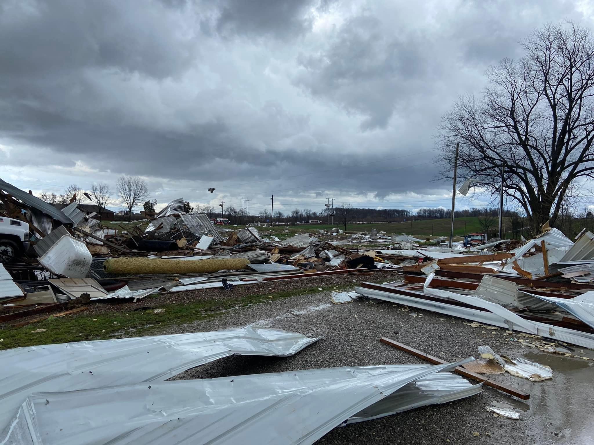
Tornado #1 - Fremont, KY (South of Paducah)
|
||||||||||||||||
 |
 |
 |
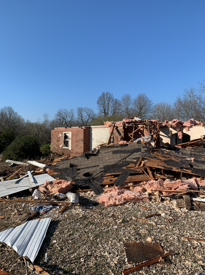 |
| Tornado damage - courtesy of Noah Bergren | Tornado damage - courtesy of Noah Bergren | NWS Storm Survey of Tornado damage | NWS Storm Survey of Tornado damage |
|
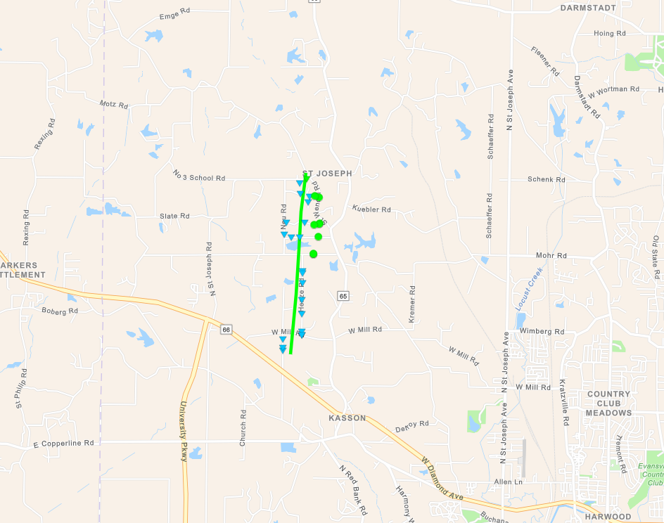
Tornado #2 - St. Joseph, Indiana
|
||||||||||||||||
|
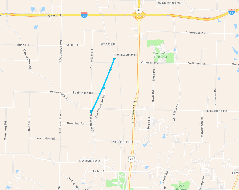
Tornado #3 - Darmstadt, Indiana
|
||||||||||||||||
|
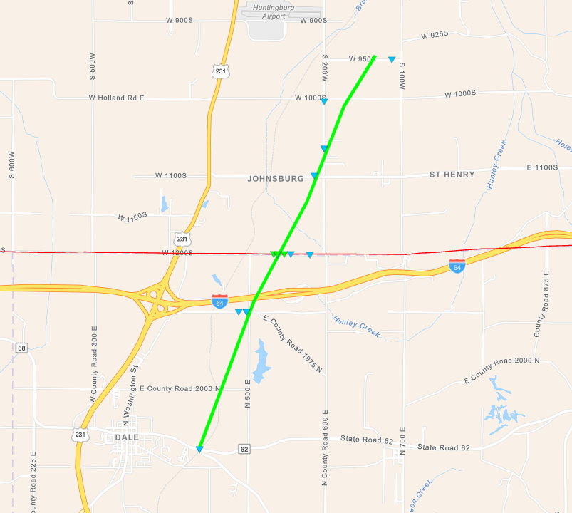
Tornado #4 - Dale, Indiana
|
||||||||||||||||
|
Tornado #5 - Smith Mills, Kentucky
|
||||||||||||||||
|
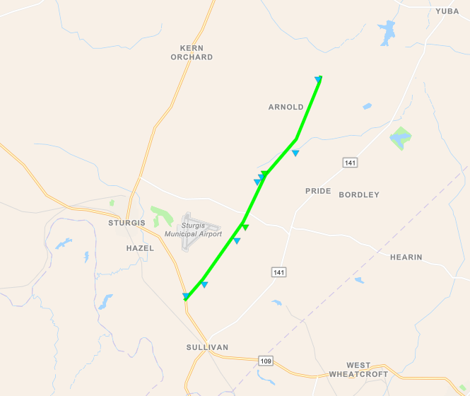
Tornado #6 - Sturgis, Kentucky
|
||||||||||||||||
|
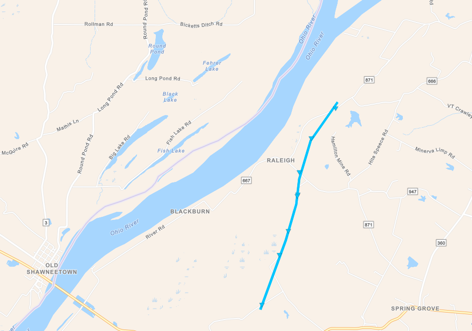
Tornado #7 - Western Union County Kentucky #1
|
||||||||||||||||
|
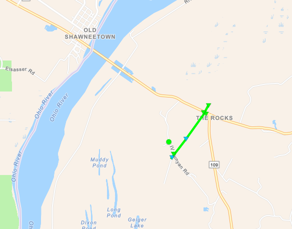
Tornado #8 - Western Union County Kentucky #2
|
||||||||||||||||
The Enhanced Fujita (EF) Scale classifies tornadoes into the following categories:
| EF0 Weak 65-85 mph |
EF1 Moderate 86-110 mph |
EF2 Significant 111-135 mph |
EF3 Severe 136-165 mph |
EF4 Extreme 166-200 mph |
EF5 Catastrophic 200+ mph |
 |
|||||
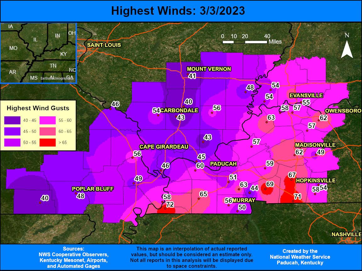
Wind:
Widespread wind gusts of 50 to 70 mph occurred across the region. Some areas across western Kentucky observed their strongest winds along the line of storms that moved through between 10:30 AM and 1 PM. These were generally in the 60 to 70 mph range. Most areas tended to observe their strongest winds after the rain ended though. Many locations, including Paducah and Evansville, recorded wind gusts in the 55 to 62 mph range anywhere from 20 minutes to 3 hours afterwards. Highest winds were along and to the east of the surface low pressure track that moved from New Madrid, MO to Paducah, KY and Evansville, IN.
The extreme wind produced widespread power outages across Kentucky. At the peak of the event, over 500,000 customers were without power across the entire state. You can find a listing of the highest wind gusts at select stations below the wind graphic.
 |
| Location | County | Provider | Time/Date | Speed | Cause |
| Hickman KY 2 E | Fulton | KYMN2 | 3/3/2023 10:40 | 72 | Thunderstorm |
| Fort Campbell KY | Christian | AWOS | 3/3/2023 12:06 | 71 | Thunderstorm |
| Cadiz KY 4 SW | Trigg | KYMN2 | 3/3/2023 11:55 | 69 | Thunderstorm |
| Hopkinsville KY 6 N | Christian | KYMN2 | 3/3/2023 12:10 | 67 | Thunderstorm |
| Mayfield KY 6 SW | Graves | KYMN2 | 3/3/2023 11:00 | 65 | Thunderstorm |
| Greenville KY 6 N | Muhlenberg | KYMN2 | 3/3/2023 12:35 | 65 | Thunderstorm |
| Murray KY | Marshall | CWOP | 3/3/2023 11:38 | 63 | Thunderstorm |
| Morganfield KY 4 E | Union | KYMN2 | 3/3/2023 12:15 | 63 | Thunderstorm |
| Madisonville KY | Hopkins | AWOS | 3/3/2023 13:15 | 62 | Non-Thunderstorm |
| Murray KY | Calloway | AWOS | 3/3/2023 13:15 | 62 | Non-Thunderstorm |
| Owensboro KY | Daviess | AWOS | 3/3/2023 13:56 | 62 | Non-Thunderstorm |
| Evansville IN | Vanderburgh | ASOS | 3/3/2023 15:35 | 62 | Non-Thunderstorm |
| Madisonville KY 4 S | Hopkins | KYMN2 | 3/3/2023 15:40 | 62 | Non-Thunderstorm |
| Paducah KY | McCracken | ASOS | 3/3/2023 11:36 | 60 | Non-Thunderstorm |
| Princeton KY 2 SE | Caldwell | KYMN2 | 3/3/2023 12:50 | 59 | Non-Thunderstorm |
| Dorena MO | Mississippi | CWOP | 3/3/2023 13:00 | 58 | Non-Thunderstorm |
| Elkton KY 5 SW | Todd | KYMN2 | 3/3/2023 14:00 | 58 | Non-Thunderstorm |
| Henderson KY | Henderson | AWOS | 3/3/2023 15:34 | 58 | Non-Thunderstorm |
| Calhoun KY 5 NW | McLean | KYMN2 | 3/3/2023 13:05 | 57 | Non-Thunderstorm |
| Henderson KY 5 E | Henderson | KYMN2 | 3/3/2023 13:45 | 57 | Non-Thunderstorm |
| Marion KY 4 NE | Crittenden | KYMN2 | 3/3/2023 14:55 | 57 | Non-Thunderstorm |
| Murray KY 1 W | Calloway | KYMN2 | 3/3/2023 11:50 | 56 | Non-Thunderstorm |
| Cape Girardeau MO | Scott | ASOS | 3/3/2023 13:58 | 56 | Non-Thunderstorm |
| Harrisburg IL | Saline | AWOS | 3/3/2023 14:35 | 56 | Non-Thunderstorm |
| Newburgh IN | Warrick | CWOP | 3/3/2023 13:26 | 55 | Non-Thunderstorm |
| Elkton KY | Todd | CWOP | 3/3/2023 14:00 | 54 | Non-Thunderstorm |
| Carbondale IL | Jackson | ASOS | 3/3/2023 14:18 | 54 | Non-Thunderstorm |
| Mt. Vernon IN | Posey | CWOP | 3/3/2023 16:00 | 54 | Non-Thunderstorm |
| Wadesville IN | Posey | CWOP | 3/3/2023 16:02 | 54 | Non-Thunderstorm |
| Benton KY 4 N | Marshall | KYMN2 | 3/3/2023 11:55 | 51 | Non-Thunderstorm |
| New Concord KY | Calloway | CWOP | 3/3/2023 12:00 | 50 | Non-Thunderstorm |
| Sikeston MO | Scott | AWOS | 3/3/2023 13:15 | 49 | Non-Thunderstorm |
| Greenville KY | Muhlenberg | RAWS | 3/3/2023 14:55 | 49 | Non-Thunderstorm |
| Poplar Bluff MO | Butler | ASOS | 3/3/2023 12:22 | 48 | Non-Thunderstorm |
| Carmi IL | White | AWOS | 3/3/2023 15:18 | 48 | Non-Thunderstorm |
| Perryville MO | Perry | AWOS | 3/3/2023 13:15 | 46 | Non-Thunderstorm |
| Cairo IL | Alexander | AWOS | 3/3/2023 14:15 | 46 | Non-Thunderstorm |
| Metropolis IL | Massac | AWOS | 3/3/2023 12:55 | 45 | Non-Thunderstorm |
| Golden Pond KY | Trigg | RAWS | 3/3/2023 14:21 | 44 | Non-Thunderstorm |
| Dixon Springs IL | Pope | RAWS | 3/3/2023 12:08 | 43 | Non-Thunderstorm |
| Royalton IL | Franklin | CWOP | 3/3/2023 13:55 | 43 | Non-Thunderstorm |
| Marion IL | Williamson | AWOS | 3/3/2023 14:45 | 43 | Non-Thunderstorm |
| Mt Vernon IL | Jefferson | AWOS | 3/3/2023 15:23 | 41 | Non-Thunderstorm |
| Doniphan MO | Ripley | RAWS | 3/3/2023 12:53 | 40 | Non-Thunderstorm |
| West Frankfort IL | Franklin | CWOP | 3/3/2023 15:20 | 40 | Non-Thunderstorm |
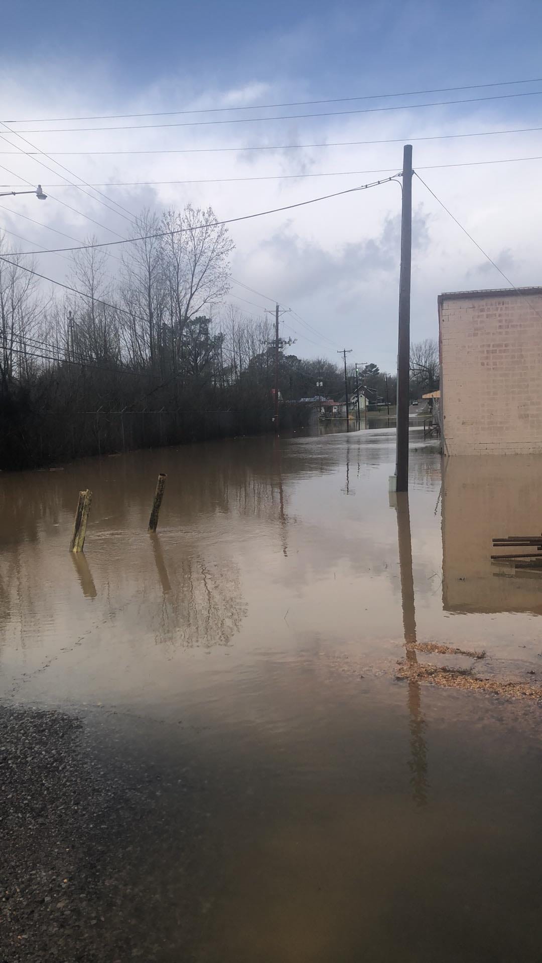
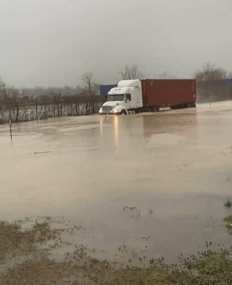
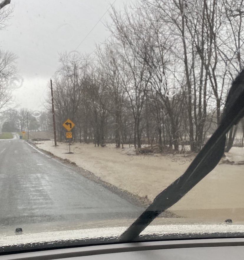
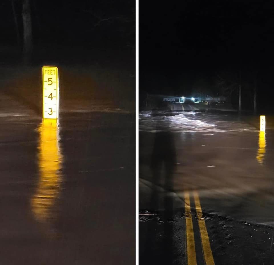
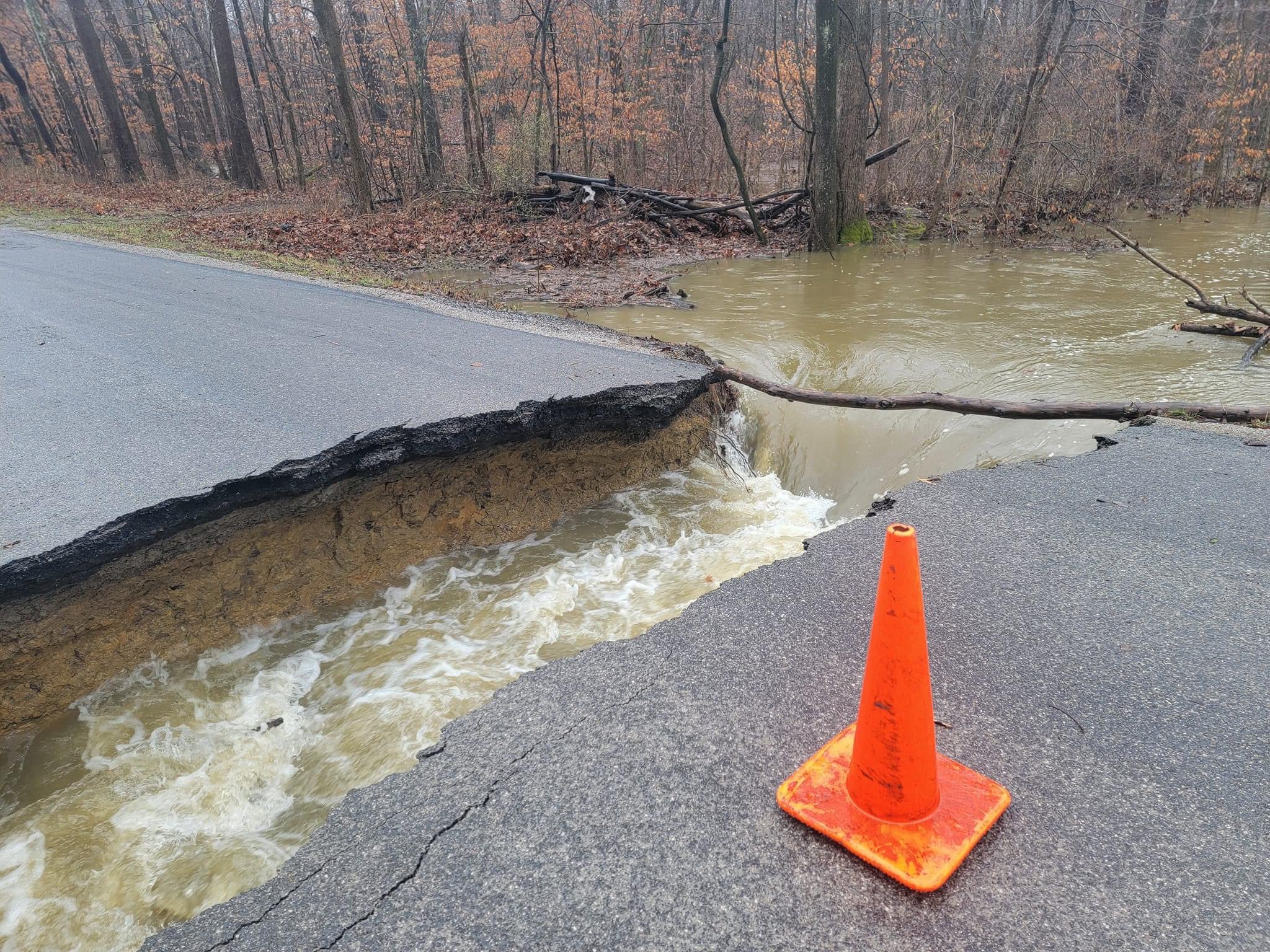
Flooding
Flash flooding was widespread across our region with numerous roads flooded/closed due to extremely heavy rainfall amounts. Flash Flood Warnings were in effect for 53 of our 58 counties during this event. Water rescues occurred due to vehicles driving into flooded roads.
The heavy rainfall on March 2-3 resulted in rises along creeks, streams, and rivers. Minor to moderate flooding was forecast to occur along many points along the Ohio, Green, Wabash, Little Wabash, Patoka, Big Muddy, St Francis, and Current Rivers in the days after the event.
Photos
 |
 |
 |
 |
| Flooding in Fulton, KY - courtesy of Allison Garber | Flooding in Mayfield, KY - courtesy of Jenn Schism | Flooding west of Cambria, IL. Water was over road earlier in the morning - courtesy of Steve on Twitter | Little Black Creek Ripley County, MO - courtesy of Dee Dee Sparks |
 |
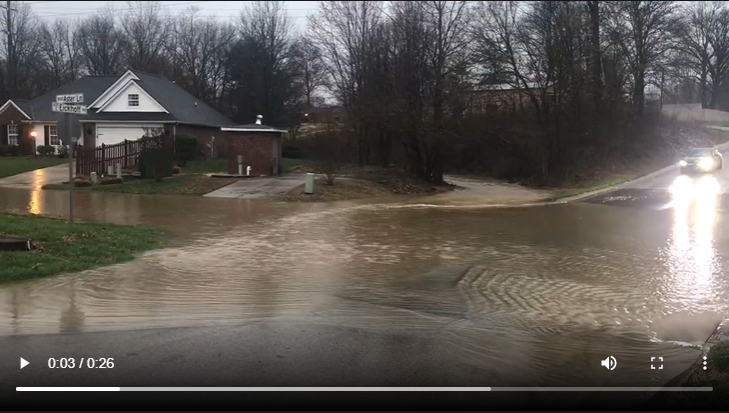 |
| Road washed out in Jefferson County, IL near Bluford - courtesy of Jefferson County Highway Department | Water over intersection of Eickhoff Road and Aster Lane in Evansville, IN - courtesy of Deb Dorsey |
All-Time Lowest Pressure
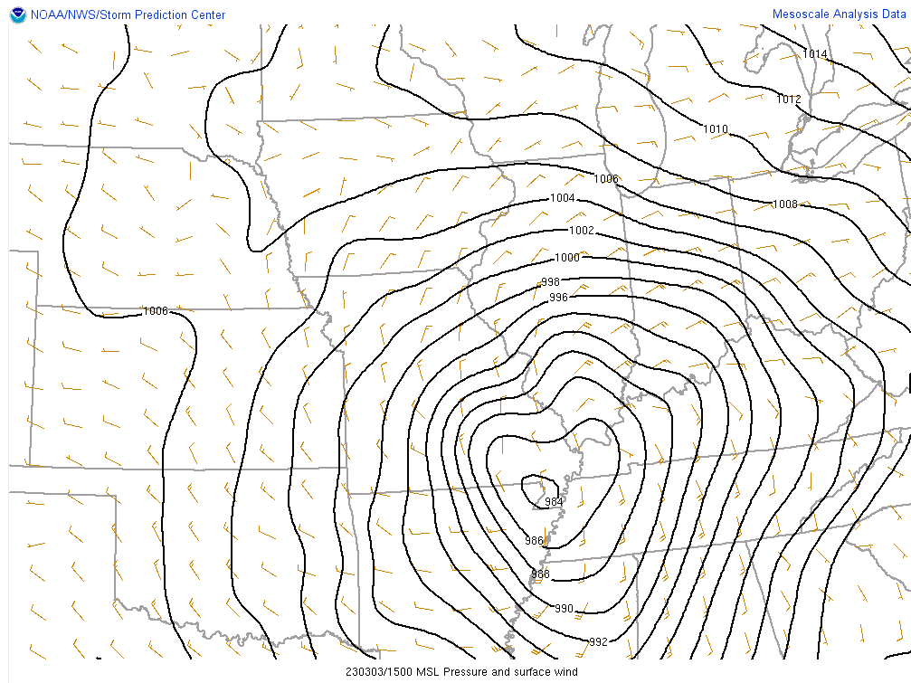
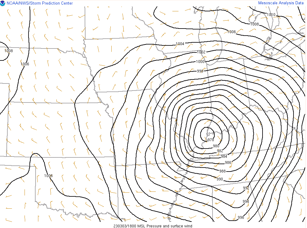
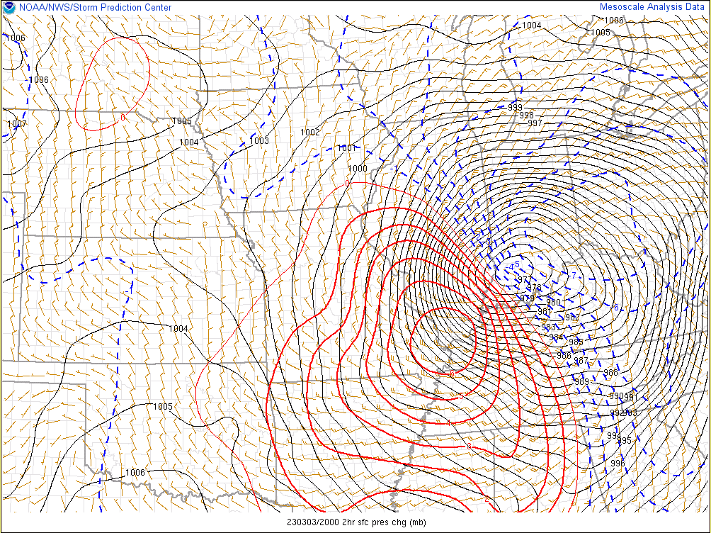
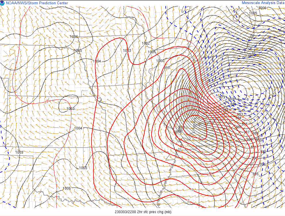
A surface low moved northeast from Texarkana, AR around 9 PM on March 2nd to Evansville, IN around 1 PM on March 3rd. It rapidly deepened as it moved from northeast Arkansas to New Madrid, MO and then up the Ohio River from Paducah, KY to Evansville. By 6 PM on March 3rd it was already located near Columbus, OH. The pressure dropped 13mb from 989mb to 976mb over a 7 hour period. This was very rare for our region to experience barometic pressure levels this low. In fact, both Paducah and Evansville recorded their all-time lowest pressure on record. For comparison this was roughly 10mb lower than what the pressure was when Hurricane Ike passed through the region back in September 2008. Pressure falls of 8 to 10 mb in 2 hours occurred during the afternoon as the low pressure system lifted to the northeast.
 |
| Caption |
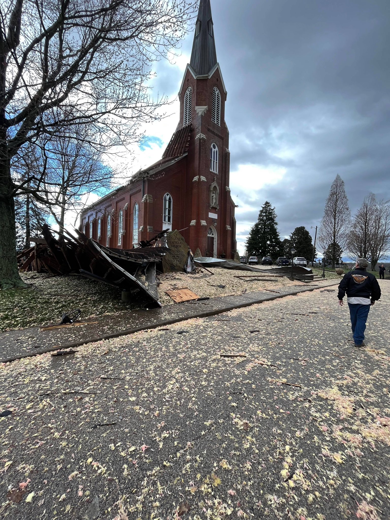
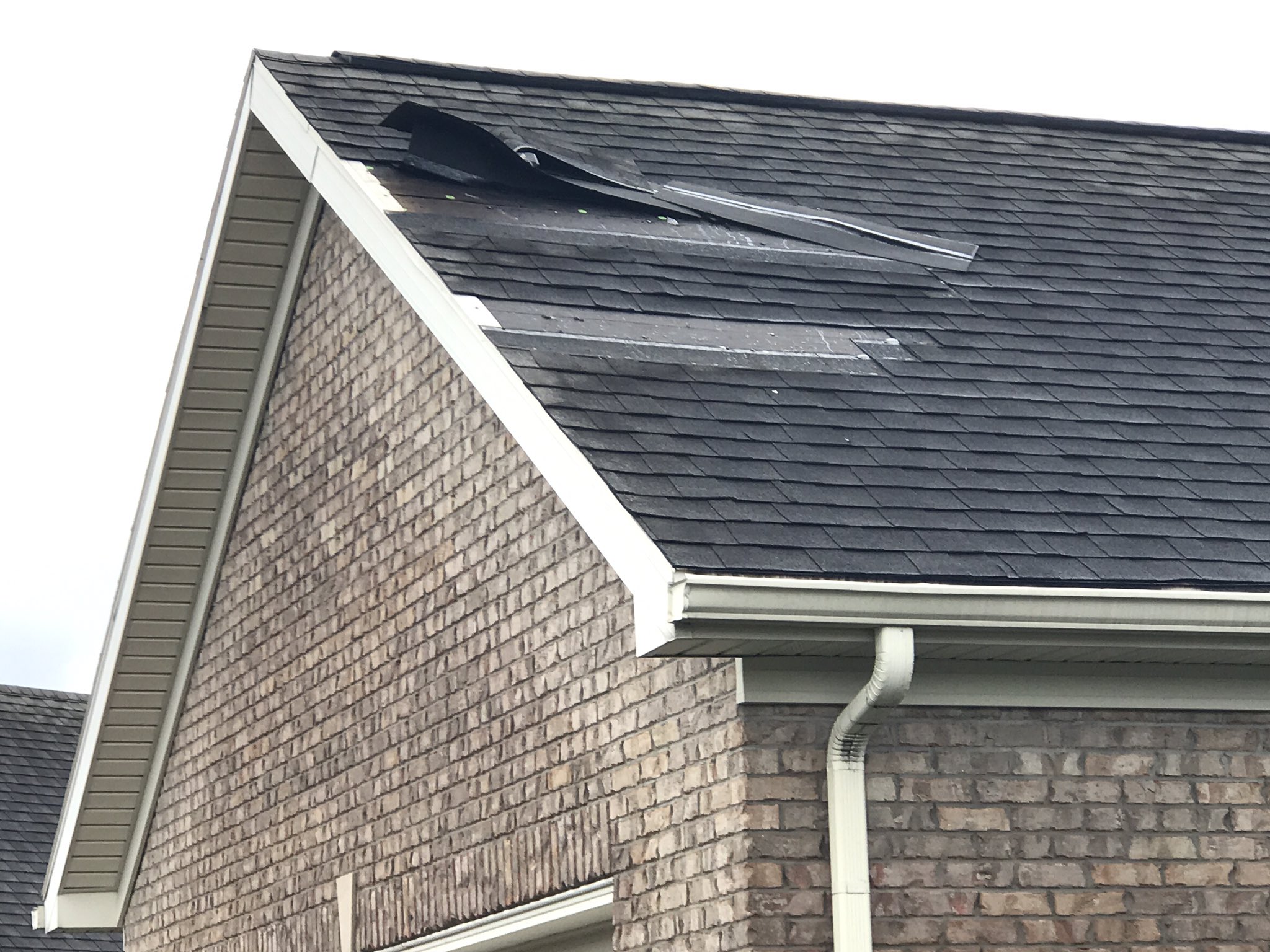
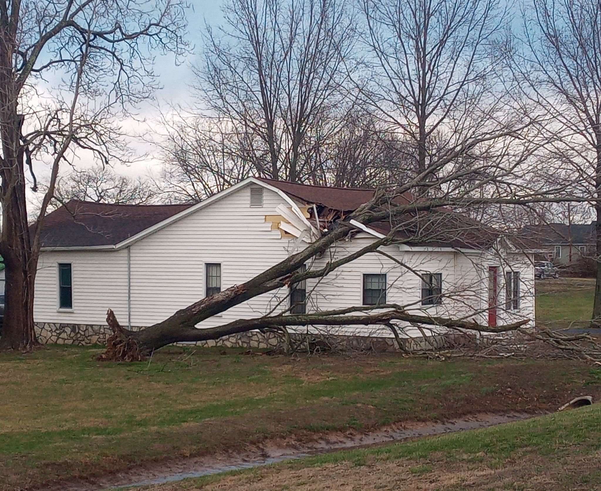
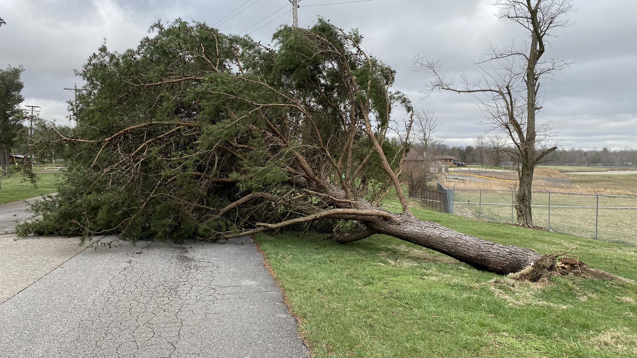
Photos of Wind Damage
 |
 |
 |
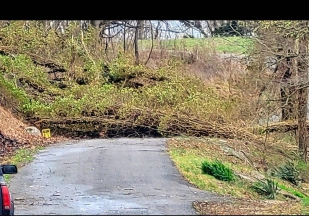 |
| St Joesph, Indiana church damage - courtesy of EvansvilleWatch | St Joesph, Indiana church damage - courtesy of EvansvilleWatch | Shingle damage west side of Evansville, IN - courtesy of Deb Dorsey | Tree across road in Cadiz, KY - courtesy of Kathy Hines |
 |
 |
 |
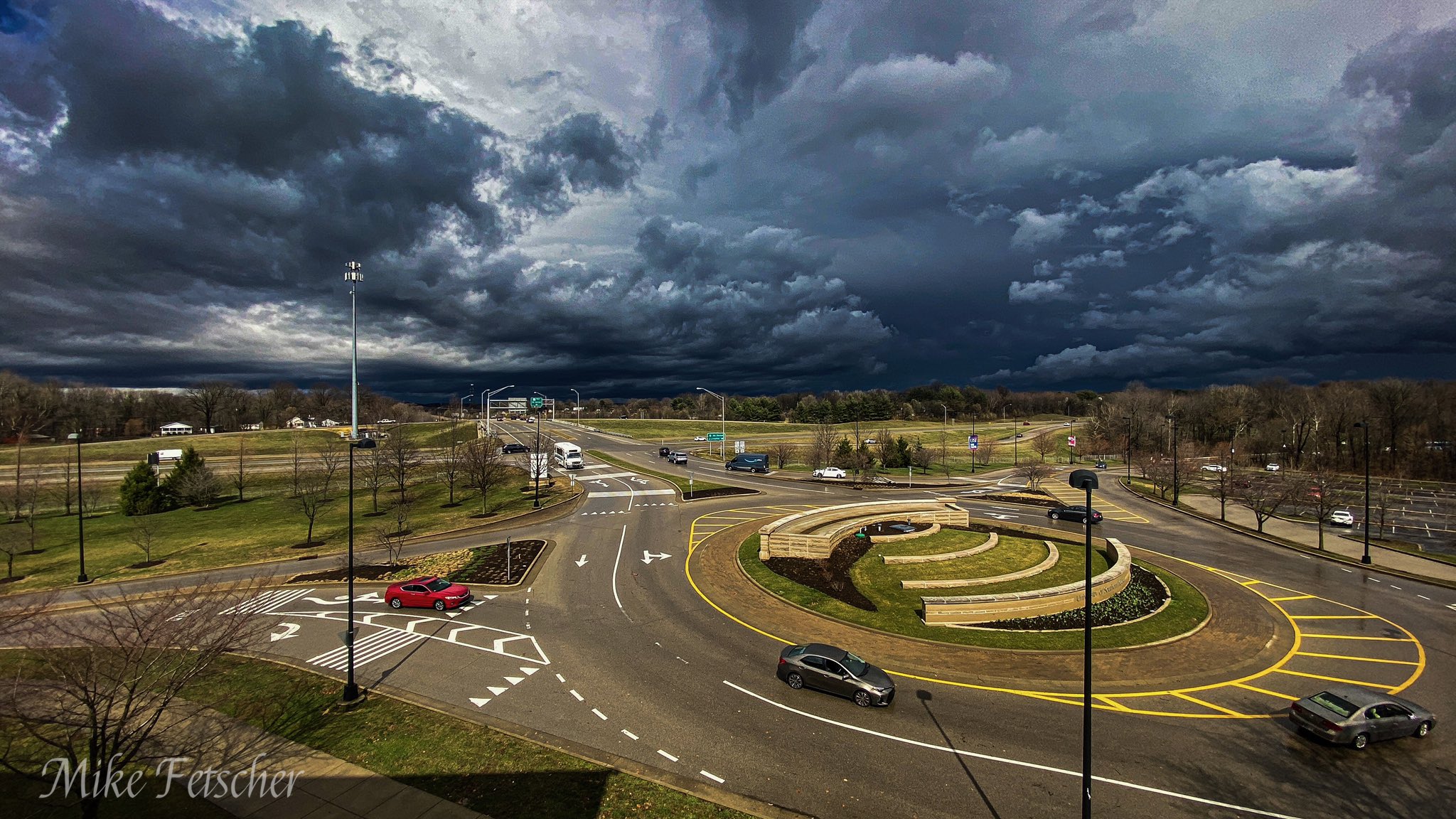 |
| Tree on house in Herrin, IL - courtesy of Michael Bruce | Storm damage in Dale, IN - courtesy of HeisenbergFX4 on Twitter | Lots of uprooted trees in Diamond Lake Campground area of Daviess County KY - courtesy of Chris Conley | View after storms passed at USI in Evansville - courtesy of Mike Fetscher |
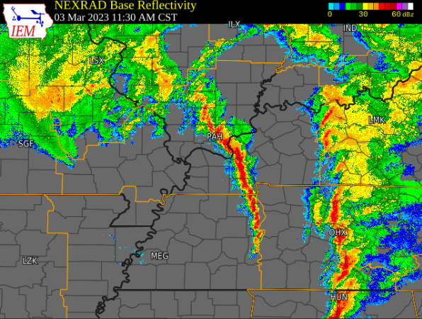
Radar
Click here for a radar loop from this event. The loop runs from 8 PM March 2nd through 2 PM on March 3rd. Waves of moderate to heavy rain overspread the region from the evening of March 2nd through the morning on March 3rd. The line of storms that produced significant damage across west Kentucky, far southeast Illinois, and southwest Indiana moved through between 10:30 AM and 1 PM.
 |
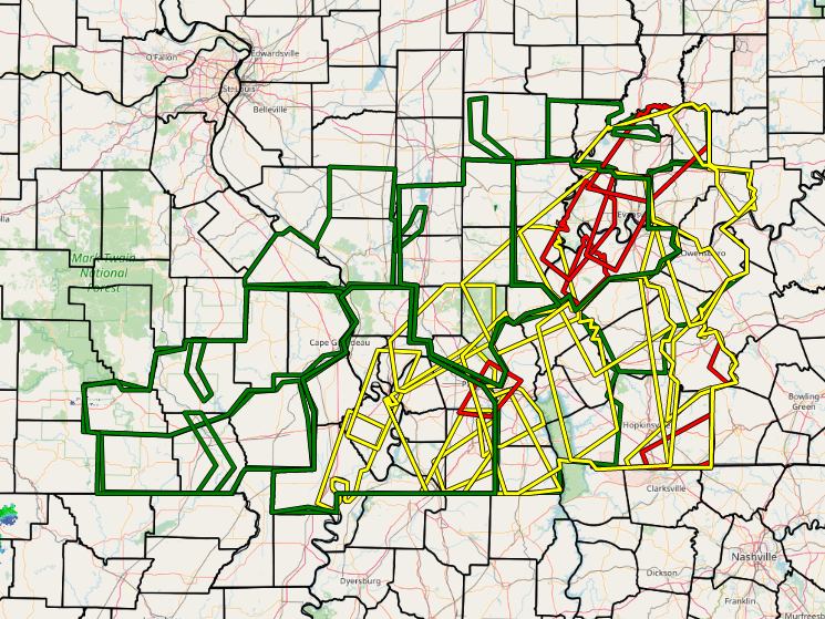 |
| Screenshot of the line of storms extending from Dixon Springs, Illinois to Benton and Murray, Kentucky at 11:30 AM on March 3, 2023. | All Warnings issued during this event - Green (Flash Flood), Yellow (Severe Thundestorm), and Red (Tornado) |
Storm Reports
PRELIMINARY LOCAL STORM REPORT...SUMMARY NATIONAL WEATHER SERVICE PADUCAH KY 219 PM CST SAT MAR 4 2023 ..TIME... ...EVENT... ...CITY LOCATION... ...LAT.LON... ..DATE... ....MAG.... ..COUNTY LOCATION..ST.. ...SOURCE.... ..REMARKS.. 0400 AM FLASH FLOOD MARBLE HILL 37.31N 89.98W 03/03/2023 BOLLINGER MO EMERGENCY MNGR FLOOD WATERS FROM CROOKED CREEK COVERED HIGHWAY 51 AND ENTERED A STORE ON THE NORTH SIDE OF TOWN. 0422 AM HEAVY RAIN 1 SSE CHICOPEE 36.98N 91.00W 03/03/2023 M2.69 INCH CARTER MO MESONET 12 HOUR RAINFALL TOTAL. MESONET STATION BGSM7 CHICOPEE MO. 0429 AM FLASH FLOOD 4 NE GORHAM 37.75N 89.43W 03/03/2023 JACKSON IL TRAINED SPOTTER DITCHES OVERFLOWING ONTO ROADWAYS, ROADWAYS NOT PASSABLE IN PLACES. 0442 AM FLOOD 5 NNW BROUGHTON 38.00N 88.49W 03/03/2023 HAMILTON IL COUNTY OFFICIAL WATER OVER BOTH LANES OF STATE RT. 142 NEAR DIGBY ROAD, ABOUT AN INCH DEEP. 0455 AM HEAVY RAIN 5 SW MARION 37.68N 89.00W 03/03/2023 M2.56 INCH WILLIAMSON IL MESONET 12 HOUR RAINFALL TOTAL. MESONET STATION COWI2 CRAB ORCHARD IL. 0523 AM FLOOD MCLEANSBORO 38.09N 88.54W 03/03/2023 HAMILTON IL COUNTY OFFICIAL WATER OVER E. RANDOLPH STREET IN SEVERAL LOCATIONS IN MCLEANSBORO, AND STATE RT. 142. 0527 AM HEAVY RAIN 3 W NEWBURGH 37.95N 87.46W 03/03/2023 M2.10 INCH VANDERBURGH IN PUBLIC SOME FLOODING OF LOW LYING AREAS ON SOUTHEAST SIDE OF EVANSVILLE. 0530 AM HEAVY RAIN 4 SSW GRAVELTON 37.24N 90.27W 03/03/2023 M2.87 INCH WAYNE MO MESONET 12 HOUR RAINFALL TOTAL. MESONET STATION PMRM7 PIEDMONT MO. 0534 AM FLOOD ROYALTON 37.88N 89.11W 03/03/2023 FRANKLIN IL EMERGENCY MNGR WATER OVER ROAD IN CENTER OF TOWN, MINOR WATER ISSUES IN OTHER PARTS OF THE COUNTY. 0548 AM HEAVY RAIN GAGE 37.00N 88.89W 03/03/2023 M3.12 INCH BALLARD KY MESONET 12 HOUR RAINFALL TOTAL. MESONET STATION EW0626 GAGE. 0550 AM HEAVY RAIN 1 N ELLSINORE 36.95N 90.75W 03/03/2023 M3.09 INCH CARTER MO MESONET 12 HOUR RAINFALL TOTAL. MESONET STATION GW1603 ELLSINORE. 0552 AM HEAVY RAIN 3 SSW DE SOTO 37.78N 89.25W 03/03/2023 M2.74 INCH JACKSON IL ASOS 12 HOUR RAINFALL TOTAL. ASOS STATION KMDH CARBONDALE IL. 0553 AM HEAVY RAIN 3 WNW SCOTT CITY 37.23N 89.58W 03/03/2023 M2.88 INCH SCOTT MO ASOS 12 HOUR RAINFALL TOTAL. ASOS STATION KCGI CAPE GIRARDEAU MO. 0553 AM HEAVY RAIN 5 W ASH HILL 36.77N 90.32W 03/03/2023 M2.72 INCH BUTLER MO ASOS 12 HOUR RAINFALL TOTAL. ASOS STATION KPOF POPLAR BLUFF MO. 0553 AM HEAVY RAIN 2 SE HEATH 37.07N 88.77W 03/03/2023 M2.56 INCH MCCRACKEN KY ASOS 12 HOUR RAINFALL TOTAL. ASOS STATION KPAH PADUCAH KY. 0555 AM HEAVY RAIN 1 SE ENERGY 37.77N 89.02W 03/03/2023 M2.69 INCH WILLIAMSON IL AWOS 12 HOUR RAINFALL TOTAL. AWOS STATION KMWA MARION IL. 0600 AM FLASH FLOOD 8 SE GRANDIN 36.75N 90.74W 03/03/2023 RIPLEY MO DEPT OF HIGHWAYS ROUTE K SOUTH OF BUDAPEST IS CLOSED BECAUSE OF FLOODING. 0600 AM HEAVY RAIN 2 SE CAPE GIRARDEAU 37.29N 89.53W 03/03/2023 M3.42 INCH CAPE GIRARDEAU MO COCORAHS 24 HOUR RAINFALL TOTAL AT MO-CG-12: CAPE GIRARDEAU 1.8 SE. 0600 AM FLASH FLOOD PADUCAH 37.07N 88.64W 03/03/2023 MCCRACKEN KY DEPT OF HIGHWAYS FLOODING HAS CLOSED SEVERAL ROADS IN MCCRACKEN COUNTY. KY 1255/BONDS ROAD IS CLOSED AT THE 1 TO 2MM JUST WEST OF THE KY 450/OAKS RD INTERSECTION. KY 994/OLD MAYFIELD ROAD IS CLOSED AT 5.5 TO 5.7MM AT THE KY 1410/HOUSER ROAD INTERSECTION. KY 1410/HOUSER ROAD IS CLOSED NEAR CHAMPION CREEK FROM 3.2 TO 3.7MM NEAR THE KY 994/OLD MAYFIELD ROAD INTERSECTION. 0600 AM FLASH FLOOD HENDERSON 37.84N 87.58W 03/03/2023 HENDERSON KY PUBLIC CURB DEEP FLOODING IN HENDERSON KENTUCKY BY WATSON LANE AND GREEN RIVER RIVER ROAD. 0600 AM FLASH FLOOD ARLINGTON 36.79N 89.01W 03/03/2023 CARLISLE KY DEPT OF HIGHWAYS KY 80 WEST IS CLOSED AT 2.8MM IN ARLINGTON JUST WEST OF U.S. 51. ALSO, KY 307 IS CLOSED NEAR THE 7MM BETWEEN KY 121 AND U.S. 62 DUE TO FLOODING. 0600 AM FLASH FLOOD 4 N MCLEANSBORO 38.15N 88.54W 03/03/2023 HAMILTON IL EMERGENCY MNGR STATE ROUTE 242 AND BLAIRSVILLE RD IS SUBMERGED POSSIBLY 2-3 INCHES DEEP. 0615 AM HEAVY RAIN CARBONDALE 37.72N 89.22W 03/03/2023 M2.95 INCH JACKSON IL COCORAHS STORM TOTAL SO FAR AT UNITY POINT SCHOOL COCORAHS STATION. 0618 AM HEAVY RAIN CAVE-IN-ROCK 37.47N 88.17W 03/03/2023 M2.50 INCH HARDIN IL TRAINED SPOTTER STORM TOTAL RAINFALL SO FAR. 0620 AM HEAVY RAIN 2 E HICKMAN 36.56N 89.15W 03/03/2023 M2.52 INCH FULTON KY MESONET STORM TOTAL RAINFALL SO FAR AT HICKMAN COUNTY MESONET. 0620 AM HEAVY RAIN 5 NNE LA CENTER 37.14N 88.94W 03/03/2023 M2.49 INCH BALLARD KY MESONET STORM TOTAL RAINFALL SO FAR AT BALLARD MESONET. 0630 AM FLASH FLOOD FULTON 36.51N 88.88W 03/03/2023 FULTON KY PUBLIC HARRIS FORK CREEK OVERFLOWING AND FLOODING DOWNTOWN FULTON. 0630 AM FLASH FLOOD EVANSVILLE 37.98N 87.54W 03/03/2023 VANDERBURGH IN TRAINED SPOTTER WATER OVER INTERSECTION OF EICKHOFF RD AND ASTER LN. 0630 AM FLASH FLOOD ELDORADO 37.81N 88.44W 03/03/2023 SALINE IL TRAINED SPOTTER WATER OVER ROADS IN TOWN. 0630 AM FLASH FLOOD CARBONDALE 37.72N 89.22W 03/03/2023 JACKSON IL TRAINED SPOTTER US 51 AND INDUSTRIAL PARK IS UNDER WATER IN CARBONDALE. 0700 AM HEAVY RAIN 1 SSE LEEPER 37.06N 90.70W 03/03/2023 M3.39 INCH WAYNE MO COCORAHS 24 HOUR RAINFALL TOTAL AT COCORAHS SITE MO-WY-3: MILL SPRING 1.3 WSW. 0700 AM HEAVY RAIN 4 S GRAND RIVERS 36.95N 88.24W 03/03/2023 M2.52 INCH MARSHALL KY TRAINED SPOTTER STORM TOTAL RAINFALL SO FAR. 0700 AM HEAVY RAIN 3 E WINGO 36.64N 88.68W 03/03/2023 M3.00 INCH GRAVES KY TRAINED SPOTTER 3 MILES EAST OF WINGO KY AT 339 AND 129 INTERSECTION. 0700 AM HEAVY RAIN DE SOTO 37.82N 89.23W 03/03/2023 M3.18 INCH JACKSON IL COCORAHS 24 HOUR RAINFALL TOTAL. COCORAHS SITE IL-JK-14: DE SOTO 0.3 ESE. 0703 AM FLOOD 2 ENE PITTSBURG 37.79N 88.82W 03/03/2023 WILLIAMSON IL TRAINED SPOTTER WATER OVER DWINA RD. 0708 AM HEAVY RAIN 3 WNW ELLSINORE 36.95N 90.80W 03/03/2023 M3.20 INCH CARTER MO COCORAHS 24 HOUR RAINFALL TOTAL. MO-CT-1: ELLSINORE 4.8 WNW. 0710 AM HEAVY RAIN 2 W CREAL SPRINGS 37.62N 88.88W 03/03/2023 M2.98 INCH WILLIAMSON IL COCORAHS 24 HOUR RAINFALL TOTAL AT COCORAHS SITE IL-WM-18: CREAL SPRINGS 2.2 W. 0711 AM HEAVY RAIN NEWBURGH 37.95N 87.40W 03/03/2023 M3.01 INCH WARRICK IN COCORAHS 24 HOUR RAINFALL TOTAL AT COCORAHS SITE IN-WK-25: NEWBURGH 0.3 SE. 0715 AM FLASH FLOOD 3 N LOVELACEVILLE 37.01N 88.84W 03/03/2023 BALLARD KY EMERGENCY MNGR US 62 CLOSED AT BALLARD/CARLISLE COUNTY LINE. 0723 AM FLOOD 1 E OXLY 36.59N 90.66W 03/03/2023 RIPLEY MO LAW ENFORCEMENT HIGHWAY 142 EAST OF OXLY CLOSED DUE TO HIGH WATER. SOME SECONDARY ROADS WATER COVERED ACROSS THE COUNTY. 0730 AM FLASH FLOOD CLINTON 36.67N 88.99W 03/03/2023 HICKMAN KY TRAINED SPOTTER KY 307 IS CLOSED AT THE 13 TO 14MM AND KY 58 IS CLOSED AT THE 7 TO 8MM DUE TO FLOODING. 0730 AM FLASH FLOOD FULTON 36.51N 88.88W 03/03/2023 FULTON KY DEPT OF HIGHWAYS KY 94 IS CLOSED AT THE 7 TO 11MM IN THE LOWER BOTTOM DIP AREA BETWEEN KY 311 AND KY 1099 IN FULTON COUNTY DUE TO WATER OVER ROAD. 0730 AM FLASH FLOOD BENTON 38.01N 88.92W 03/03/2023 FRANKLIN IL TRAINED SPOTTER KY 1949/WADESBORO ROAD IS CLOSED AT THE 7 TO 9 MILE MARKER NEAR THE I-69 TUNNEL AND KY 1462/BENTON-BIRMINGHAM RD IS CLOSED AT THE 0 TO 2MM AT THE CLARKS RIVER BRIDGE DUE TO FLOODING. 0740 AM FLASH FLOOD MCLEANSBORO 38.09N 88.53W 03/03/2023 HAMILTON IL EMERGENCY MNGR MULTIPLE REPORTS OF CULVERTS BEING WASHED OUT AND SINKHOLES FORMING IN HAMILTON COUNTY. 0800 AM FLASH FLOOD 2 WNW EDDYVILLE 37.09N 88.11W 03/03/2023 LYON KY TRAINED SPOTTER STEADY RAIN, HEAVY WATER FLOWS ACROSS THE GROUND IN WATERWAYS, AN INCH HAS FALLEN SINCE 5:30 A.M., 2.44 TOTAL IN 4" RAIN GAUGE. 2 MILES N OF KUTTAWA. WATER RUNNING ACROSS THE ROAD IN PLACES. 0800 AM HEAVY RAIN HERRIN 37.81N 89.03W 03/03/2023 M3.15 INCH WILLIAMSON IL TRAINED SPOTTER TOTAL RAINFALL AT 8:00AM. 0800 AM HEAVY RAIN MURPHYSBORO 37.77N 89.34W 03/03/2023 M3.31 INCH JACKSON IL EMERGENCY MNGR 3.31 INCHES OF RAIN IN MURPHYSBORO. 0822 AM HEAVY RAIN 1 N DUDLEY 36.80N 90.09W 03/03/2023 M3.20 INCH STODDARD MO TRAINED SPOTTER 3.20 INCHES OF RAIN SINCE MIDNIGHT. 0828 AM FLASH FLOOD 7 SE WINSLOW 38.31N 87.13W 03/03/2023 PIKE IN TRAINED SPOTTER CUP CREEK AND TRIBUTARIES ALL OVERFLOWING INTO SURROUNDING FIELDS. SOME COUNTY ROADS HAVE WATER RUNNING DOWN AND OVER THEM. FIELDS FILLING WITH WATER. PONDING ON SR 64 IN PLACES WHERE HIGHWAY DITCHES ARE FULL AND SPILLING ONTO ROAD. 0830 AM FLASH FLOOD 8 SE WINSLOW 38.30N 87.12W 03/03/2023 PIKE IN COCORAHS CUP CREEK AND TRIBUTARIES OUT OF THEIR BANKS AND FLOODING FIELDS. HIGHWAY DITCHES ARE FULL AND PONDING ON ROADS. COUNTY ROADS ARE FLOODED OR WATER RUNNING DOWN THEM IN HILLY AREAS. VERY HEAVY RAIN CONTINUES. RAINFALL OF 3 INCHES SO FAR. REPORT FROM COCORAHS SITE HOLLAND 6.3 NW. 0838 AM HEAVY RAIN 2 S HICKORY 36.80N 88.65W 03/03/2023 M3.26 INCH GRAVES KY CO-OP OBSERVER 0900 AM HEAVY RAIN KEVIL 37.08N 88.89W 03/03/2023 M3.84 INCH BALLARD KY TRAINED SPOTTER 0904 AM HEAVY RAIN MURPHYSBORO 37.76N 89.33W 03/03/2023 M3.60 INCH JACKSON IL PUBLIC 0910 AM HEAVY RAIN 6 W EVANSVILLE 37.98N 87.65W 03/03/2023 M3.20 INCH VANDERBURGH IN TRAINED SPOTTER 0920 AM HEAVY RAIN MOUNT VERNON 37.93N 87.90W 03/03/2023 M4.00 INCH POSEY IN PUBLIC 4.00 INCHES OF RAIN AS OF 9:20 AM. 0926 AM FLASH FLOOD 4 SSE HENDERSON 37.78N 87.56W 03/03/2023 HENDERSON KY TRAINED SPOTTER WATER COVERING PART OF THE ROADWAY ON US 41 SOUTH AT SMITH STAPLES ROAD. 0929 AM HEAVY RAIN 6 E SANTA CLAUS 38.12N 86.81W 03/03/2023 M2.90 INCH SPENCER IN TRAINED SPOTTER SIGNIFICANT FLOODING ALONG THE ANDERSON RIVER NEAR THIS LOCATION. 1018 AM FLASH FLOOD 3 SW CALVERT CITY 37.01N 88.39W 03/03/2023 MARSHALL KY TRAINED SPOTTER US-62 BETWEEN CALVERT CITY AND POSSUM TROT IS EXPERIENCING LOCALIZED FLOODING WITH SOME SIDE ROADS COVERED. 1020 AM HEAVY RAIN 4 S GRAND RIVERS 36.95N 88.24W 03/03/2023 M3.41 INCH MARSHALL KY TRAINED SPOTTER 1034 AM FLASH FLOOD PORTAGEVILLE 36.43N 89.70W 03/03/2023 NEW MADRID MO TRAINED SPOTTER WATER OVER THE ROAD IN A COUPLE SPOTS ALONG ROUTE T NEAR PORTAGEVILLE. 1040 AM TSTM WND GST 2 ENE HICKMAN 36.57N 89.16W 03/03/2023 M72 MPH FULTON KY MESONET MESONET STATION HCKM HICKMAN KY 2 E. 1100 AM TSTM WND GST 6 SW MAYFIELD 36.70N 88.72W 03/03/2023 M65 MPH GRAVES KY MESONET MESONET STATION PRYB MAYFIELD KY 6 SW. 1108 AM TORNADO 5 NNE BOAZ 36.96N 88.61W 03/03/2023 MCCRACKEN KY NWS STORM SURVEY CORRECTS PREVIOUS TORNADO REPORT FROM 5 NNE BOAZ. AN EF-2 TORNADO BEGAN AT 1108 AM CST JUST WEST OF THE INTERSECTION OF OLD MAYFIELD ROAD AND MCNEIL ROAD. TRAVELING NNE, THE TORNADO PARALLELED OLD MAYFIELD ROAD, DOING SIGNIFICANT ROOF, SIDING, AN FASCIA DAMAGE TO ROUGHLY TWO DOZEN HOMES. A COUPLE HOMES HAD MOST OF THE THEIR ROOFING STRUCTURE REMOVED COMPLETELY. SEVERAL OUTBUILDINGS WERE COMPLETELY DESTROYED. NUMEROUS WOODEN POWER POLES WERE SNAPPED OR TILTED BY TORNADIC WINDS. AFTER CROSSING HARDMONEY ROAD, THE TORNADO DID DAMAGE TO HOMES, TREES, AND OUTBUILDINGS ALONG MICHAEL DRIVE WEST BEFORE DISSIPATING AROUND 1110 AM CST. DOZENS OF TREES WERE UPROOTED OR SNAPPED, AND DOZENS MORE SUFFERED MAJOR TREE LIMB DAMAGE. ADDITIONALLY, STRONG INFLOW WINDS OF 80 TO 90 MPH CAUSED TREE DAMAGE AND MINOR STRUCTURAL DAMAGE ADJACENT TO THE TORNADO PATH ALONG MICHAEL DRIVE EAST. 1109 AM TSTM WND DMG GREENVILLE 37.21N 87.18W 03/03/2023 MUHLENBERG KY EMERGENCY MNGR SEVERAL TREES DOWN IN GREENVILLE/CENTRAL CITY AREA. 1109 AM TORNADO 5 WSW REIDLAND 36.97N 88.61W 03/03/2023 MCCRACKEN KY NWS EMPLOYEE CORRECTS PREVIOUS TORNADO REPORT FROM 5 WSW REIDLAND. DAMAGED HOMES AND TREES DOWN IN THE FREMONT AREA REPORTED BY OFF DUTY NWS EMPLOYEE. TIME DETERMINED FROM RADAR. 1110 AM TSTM WND DMG ROUND KNOB 37.25N 88.74W 03/03/2023 MASSAC IL PUBLIC LARGE SECTION OF SHINGLES REMOVED ON A HOME. ESTIMATED AT LEAST 60 MPH WINDS. 1115 AM TSTM WND DMG MURRAY 36.61N 88.32W 03/03/2023 CALLOWAY KY TRAINED SPOTTER MULTIPLE POWER POLES AND POWER LINES DOWN IN AND AROUND THE CITY. 1118 AM TSTM WND DMG 1 E SHADY GROVE 37.12N 88.55W 03/03/2023 MASSAC IL EMERGENCY MNGR TREES AND POWER POLES DOWN IN THE UNIONTOWN AREA. TIME ESTIMATED FROM RADAR. 1126 AM TSTM WND GST CALVERT CITY 37.04N 88.38W 03/03/2023 E70 MPH MARSHALL KY TRAINED SPOTTER 1130 AM HEAVY RAIN DE SOTO 37.81N 89.22W 03/03/2023 M3.73 INCH JACKSON IL COCORAHS STORM TOTAL RAINFALL OVER AN 18-HOUR PERIOD. 1135 AM TSTM WND DMG OAK GROVE 36.67N 87.43W 03/03/2023 CHRISTIAN KY TRAINED SPOTTER POLE BARN DAMAGED TREES DOWN. 1136 AM NON-TSTM WND GST 2 SE HEATH 37.07N 88.77W 03/03/2023 M60 MPH MCCRACKEN KY ASOS NON-THUNDERSTORM WIND GUST. ASOS STATION KPAH PADUCAH KY. 1138 AM TSTM WND GST 3 SE FARIDEALING 36.82N 88.20W 03/03/2023 M63 MPH MARSHALL KY MESONET PERSONAL WEATHER STATION CWOP - DW6462 MURRAY. 1150 AM NON-TSTM WND GST 1 W MURRAY 36.61N 88.34W 03/03/2023 M56 MPH CALLOWAY KY MESONET NON-THUNDERSTORM WIND GUST. MESONET STATION MRRY MURRAY KY 1 W. 1150 AM NON-TSTM WND DMG MURRAY 36.61N 88.32W 03/03/2023 CALLOWAY KY TRAINED SPOTTER SHINGLES BLOWN OFF ROOF, TREES DOWN, SIGN DESTROYED. 1155 AM TSTM WND GST 3 SW CADIZ 36.84N 87.87W 03/03/2023 M69 MPH TRIGG KY MESONET 1155 AM NON-TSTM WND GST 5 NNE BENTON 36.92N 88.34W 03/03/2023 M51 MPH MARSHALL KY MESONET NON-THUNDERSTORM WIND GUST. MESONET STATION DRFN BENTON KY 4 N. 1200 PM TSTM WND DMG 3 E STURGIS 37.55N 87.93W 03/03/2023 UNION KY FIRE DEPT/RESCUE SEVERAL BARNS DESTROYED. ESTIMATED AT LEAST 60 MPH WINDS. 1201 PM HEAVY RAIN SPILLERTOWN 37.77N 88.92W 03/03/2023 M4.50 INCH WILLIAMSON IL TRAINED SPOTTER 1206 PM NON-TSTM WND GST 2 WNW FORT CAMPBELL NOR 36.67N 87.50W 03/03/2023 M71 MPH CHRISTIAN KY AWOS AWOS STATION KHOP FORT CAMPBELL KY. 1210 PM TSTM WND GST 6 N HOPKINSVILLE 36.94N 87.49W 03/03/2023 M67 MPH CHRISTIAN KY MESONET 1215 PM TSTM WND DMG MORGANFIELD 37.68N 87.91W 03/03/2023 UNION KY EMERGENCY MNGR BARN DAMAGED ON HWY 56, SHED DAMAGED AT WMSK RADIO STATION, A ROOF GONE OFF A HOME ON THE UNION/HENDERSON COUNTY LINE. 1215 PM TSTM WND GST 4 E MORGANFIELD 37.68N 87.83W 03/03/2023 M63 MPH UNION KY MESONET 1219 PM NON-TSTM WND GST 1 N HOPKINSVILLE 36.87N 87.49W 03/03/2023 M60 MPH CHRISTIAN KY TRAINED SPOTTER 1230 PM TSTM WND DMG 4 SW SPOTTSVILLE 37.81N 87.47W 03/03/2023 HENDERSON KY EMERGENCY MNGR CORRECTS PREVIOUS TSTM WND DMG REPORT FROM 4 SW SPOTTSVILLE. HOUSE WITH MAJOR ROOF SHINGLE LOSS ON HWY 351 JUST EAST OF ZION. FURTHER DOWN THE ROAD ON HWY 351, A LARGE BARN LOST PART OF ITS ROOF. 1230 PM TSTM WND DMG 6 W EVANSVILLE 37.98N 87.68W 03/03/2023 VANDERBURGH IN TRAINED SPOTTER TREE 20INCH IN DIAMETER BLOWN OVER. A FEW SECTIONS OF ROOFING ON A HOUSE PEELED UP TO SUB-ROOFING. SCATTERED FENCING DOWN. 1230 PM TSTM WND DMG 4 WSW DARMSTADT 38.07N 87.65W 03/03/2023 VANDERBURGH IN PUBLIC ROOF BLOWN OFF ST JOE CATHOLIC CHURCH IN ST JOE. MULTIPLE UTILITY LINES AND POLES DOWN IN THE AREA AS WELL. 1230 PM HEAVY RAIN 7 E MIDWAY 37.25N 88.50W 03/03/2023 M5.20 INCH POPE IL TRAINED SPOTTER MEASURED IN BAY CITY ALONG OHIO RIVER. 1234 PM NON-TSTM WND DMG 4 NW LONE OAK 37.08N 88.71W 03/03/2023 MCCRACKEN KY NWS EMPLOYEE TREE DOWN OVER ROAD, ON POWER LINE. 1235 PM TSTM WND GST 2 WSW CENTRAL CITY 37.29N 87.16W 03/03/2023 M65 MPH MUHLENBERG KY MESONET MESONET STATION CCTY GREENVILLE KY 6 N. 1235 PM TSTM WND GST 4 E HEBBARDSVILLE 37.79N 87.30W 03/03/2023 E60 MPH HENDERSON KY TRAINED SPOTTER 1239 PM TSTM WND DMG 1 NNE OWENSBORO 37.77N 87.11W 03/03/2023 DAVIESS KY EMERGENCY MNGR TREES DOWN. 1245 PM TSTM WND DMG 3 W OWENSBORO 37.76N 87.18W 03/03/2023 DAVIESS KY TRAINED SPOTTER MOBILE HOME HOME LIFTED AND MOVED ABOUT 4 TO 5 FT. NEARBY CARPORT MOVED INTO NEIGHBORS YARD. SEVERAL BARNS DESTROYED IN THE AREA. 1245 PM TSTM WND DMG 4 WNW HOPKINSVILLE 36.87N 87.56W 03/03/2023 CHRISTIAN KY TRAINED SPOTTER SHINGLES OFF ROOFS, SOME SIDING OFF OF HOUSES AND TREES DOWN. 1245 PM TSTM WND GST 5 SW DARMSTADT 38.03N 87.63W 03/03/2023 E60 MPH VANDERBURGH IN TRAINED SPOTTER 1250 PM NON-TSTM WND GST 2 ESE PRINCETON 37.10N 87.86W 03/03/2023 M59 MPH CALDWELL KY MESONET NON-THUNDERSTORM WIND GUST. MESONET STATION PRNC PRINCETON KY 2 SE. 1253 PM HEAVY RAIN DU QUOIN 38.00N 89.24W 03/03/2023 M3.30 INCH PERRY IL TRAINED SPOTTER MULTIPLE CARS STRANDED DUE TO DRIVING INTO FLOODED ROADWAYS. 1255 PM TSTM WND GST 2 WNW FORT CAMPBELL NOR 36.67N 87.50W 03/03/2023 M71 MPH CHRISTIAN KY AWOS AWOS STATION KHOP FORT CAMPBELL KY. 1257 PM TSTM WND DMG 7 W EVANSVILLE 37.98N 87.67W 03/03/2023 VANDERBURGH IN TRAINED SPOTTER SHINGLES OFF ROOF, SIDING OFF HOUSE, TREES DOWN. 0100 PM NON-TSTM WND GST 6 S WOLF ISLAND 36.66N 89.20W 03/03/2023 M58 MPH MISSISSIPPI MO MESONET NON-THUNDERSTORM WIND GUST. MESONET STATION EW4994 DORENA MO. 0100 PM TSTM WND DMG 5 SW ROCKPORT 37.83N 87.11W 03/03/2023 SPENCER IN EMERGENCY MNGR TREES DOWN IN ROCKPORT. 3 POWER POLES DOWN ALONG WITH TREES DOWN ON HWY 161 JUST NORTH OF OWENSBORO. 0105 PM NON-TSTM WND GST 4 NW CALHOUN 37.59N 87.32W 03/03/2023 M57 MPH MCLEAN KY MESONET NON-THUNDERSTORM WIND GUST. MESONET STATION PVRT CALHOUN KY 5 NW. 0107 PM TSTM WND DMG 3 NE DALE 38.20N 86.95W 03/03/2023 SPENCER IN EMERGENCY MNGR SEMI OVERTURNED AT MILE MARKER 58 ON I-64. 0115 PM NON-TSTM WND GST 6 E MADISONVILLE 37.35N 87.40W 03/03/2023 M62 MPH HOPKINS KY AWOS NON-THUNDERSTORM WIND GUST. AWOS STATION K2I0 MADISONVILLE KY. 0115 PM NON-TSTM WND GST 3 ESE KIRKSEY 36.67N 88.37W 03/03/2023 M62 MPH CALLOWAY KY AWOS NON-THUNDERSTORM WIND GUST. AWOS STATION KCEY MURRAY KY. 0115 PM TSTM WND DMG 6 E SANTA CLAUS 38.11N 86.82W 03/03/2023 SPENCER IN TRAINED SPOTTER SEVERAL TREE LIMBS DOWN, SOME AS LARGE AS 6†IN DIAMETER. 0145 PM NON-TSTM WND GST 4 ESE HENDERSON 37.82N 87.51W 03/03/2023 M57 MPH HENDERSON KY MESONET NON-THUNDERSTORM WIND GUST. MESONET STATION GRHM HENDERSON KY 5 E. 0156 PM NON-TSTM WND GST 4 SW OWENSBORO 37.72N 87.17W 03/03/2023 M62 MPH DAVIESS KY AWOS NON-THUNDERSTORM WIND GUST. AWOS STATION KOWB OWENSBORO KY. 0158 PM NON-TSTM WND GST 3 WNW SCOTT CITY 37.23N 89.58W 03/03/2023 M56 MPH SCOTT MO ASOS NON-THUNDERSTORM WIND GUST. ASOS STATION KCGI CAPE GIRARDEAU MO. 0200 PM NON-TSTM WND GST 4 NE TRENTON 36.76N 87.21W 03/03/2023 M58 MPH TODD KY MESONET NON-THUNDERSTORM WIND GUST. MESONET STATION ZION ELKTON KY 5 SW. 0218 PM NON-TSTM WND GST 3 SSW DE SOTO 37.78N 89.25W 03/03/2023 M54 MPH JACKSON IL ASOS NON-THUNDERSTORM WIND GUST. ASOS STATION KMDH CARBONDALE IL. 0225 PM FLASH FLOOD 4 NE BROUGHTON 37.98N 88.42W 03/03/2023 HAMILTON IL EMERGENCY MNGR WATER RESCUE FOR A VEHICLE OFF IN FLOOD WATERS ON NORRIS CITY ROAD AT COUNTY ROAD 1550 E. 0235 PM NON-TSTM WND GST 1 WSW RALEIGH 37.82N 88.55W 03/03/2023 M56 MPH SALINE IL AWOS NON-THUNDERSTORM WIND GUST. AWOS STATION KHSB HARRISBURG IL. 0255 PM NON-TSTM WND GST 4 NE MARION 37.38N 88.04W 03/03/2023 M57 MPH CRITTENDEN KY MESONET NON-THUNDERSTORM WIND GUST. MESONET STATION RPTN MARION KY 4 NE. 0334 PM NON-TSTM WND GST 5 WSW HENDERSON 37.82N 87.67W 03/03/2023 M58 MPH HENDERSON KY AWOS NON-THUNDERSTORM WIND GUST. AWOS STATION KEHR HENDERSON KY. 0335 PM NON-TSTM WND GST 2 N MELODY HILL 38.05N 87.52W 03/03/2023 M62 MPH VANDERBURGH IN ASOS NON-THUNDERSTORM WIND GUST. ASOS STATION KEVV EVANSVILLE IN. 0340 PM NON-TSTM WND GST 2 ESE EARLINGTON 37.27N 87.48W 03/03/2023 M62 MPH HOPKINS KY MESONET STRONG NON-THUNDERSTORM WIND GUST. MESONET STATION ERLN MADISONVILLE KY 4 S. 0345 PM HEAVY RAIN 2 SE EVANSVILLE 37.96N 87.51W 03/03/2023 M4.00 INCH VANDERBURGH IN COCORAHS 0345 PM NON-TSTM WND DMG 2 SE EVANSVILLE 37.96N 87.51W 03/03/2023 VANDERBURGH IN COCORAHS NUMEROUS TREES AND POWER POLES DOWNED BY STRONG GRADIENT WIND GUSTS. 0400 PM HEAVY RAIN 2 WSW EVANSVILLE 37.97N 87.58W 03/03/2023 M3.75 INCH VANDERBURGH IN CO-OP OBSERVER 24 HOUR RAINFALL. 0416 PM NON-TSTM WND GST 3 E CARMI 38.08N 88.12W 03/03/2023 M53 MPH WHITE IL AWOS NON-THUNDERSTORM WIND GUST. AWOS STATION KCUL CARMI IL. 0419 PM HEAVY RAIN LYNNVILLE 38.20N 87.32W 03/03/2023 M3.84 INCH WARRICK IN TRAINED SPOTTER 0434 PM HEAVY RAIN HARRISBURG 37.74N 88.55W 03/03/2023 M3.63 INCH SALINE IL LAW ENFORCEMENT STORM TOTAL RAINFALL. 0455 PM HEAVY RAIN 2 W OWENSBORO 37.76N 87.16W 03/03/2023 M3.36 INCH DAVIESS KY TRAINED SPOTTER STORM TOTAL. 0500 PM HEAVY RAIN 1 SW MOUNT VERNON 38.30N 88.93W 03/03/2023 M2.58 INCH JEFFERSON IL TRAINED SPOTTER STORM TOTAL RAINFALL. 0534 PM HEAVY RAIN SACRAMENTO 37.42N 87.27W 03/03/2023 M2.50 INCH MCLEAN KY TRAINED SPOTTER STORM TOTAL RAINFALL. 0700 AM HEAVY RAIN 8 WSW GRANDIN 36.80N 90.97W 03/04/2023 M4.29 INCH RIPLEY MO COCORAHS STORM TOTAL RAINFALL PAST 48 HOURS. COCORAHS STATION MO-RP-7 DONIPHAN MO 14.5 NW. 0700 AM HEAVY RAIN 2 SW LONE OAK 37.02N 88.68W 03/04/2023 M4.74 INCH MCCRACKEN KY COCORAHS STORM TOTAL RAINFALL PAST 48 HOURS. COCORAHS STATION KY-MK-6 PADUCAH KY 4.5 SW. 0700 AM HEAVY RAIN HENDERSON 37.83N 87.58W 03/04/2023 M3.83 INCH HENDERSON KY COCORAHS STORM TOTAL RAINFALL PAST 48 HOURS. COCORAHS STATION KY-HS-1 HENDERSON KY 0.4 SSW. 0700 AM HEAVY RAIN 1 NNW OWENSBORO 37.78N 87.13W 03/04/2023 M4.37 INCH DAVIESS KY COCORAHS STORM TOTAL RAINFALL PAST 48 HOURS. COCORAHS STATION KY-DV-23 OWENSBORO 1.4 NNW. 0700 AM HEAVY RAIN 2 SE CHANDLER 38.02N 87.35W 03/04/2023 M4.25 INCH WARRICK IN COCORAHS STORM TOTAL RAINFALL PAST 48 HOURS. COCORAHS STATION IN-WK-22 BOONVILLE IN 4.5 WSW. 0700 AM HEAVY RAIN NEWBURGH 37.94N 87.40W 03/04/2023 M4.13 INCH WARRICK IN COCORAHS STORM TOTAL RAINFALL PAST 48 HOURS. COCORAHS STATION IN-WK-25 NEWBURGH 0.3 SE. 0700 AM HEAVY RAIN 2 N BOONVILLE 38.08N 87.28W 03/04/2023 M4.00 INCH WARRICK IN COCORAHS STORM TOTAL RAINFALL PAST 48 HOURS. COCORAHS STATION IN-WK-5 BOONVILLE IN 2.4 N. 0700 AM HEAVY RAIN 9 W EVANSVILLE 37.99N 87.72W 03/04/2023 M4.11 INCH POSEY IN COCORAHS STORM TOTAL RAINFALL PAST 48 HOURS. COCORAHS STATION IN-PS-6 MOUNT VERNON IN 10.6 ENE. 0700 AM HEAVY RAIN 9 W EVANSVILLE 37.99N 87.71W 03/04/2023 M4.05 INCH POSEY IN COCORAHS STORM TOTAL RAINFALL PAST 48 HOURS. COCORAHS STATION IN-PS-8 8 W EVANSVILLE. 0700 AM HEAVY RAIN 2 ESE BUSH 37.83N 89.10W 03/04/2023 M4.37 INCH WILLIAMSON IL COCORAHS STORM TOTAL RAINFALL PAST 48 HOURS. COCORAHS STATION IL-WM-4 BUSH IL 2 ESE. 0700 AM HEAVY RAIN 2 W CREAL SPRINGS 37.61N 88.88W 03/04/2023 M4.01 INCH WILLIAMSON IL COCORAHS STORM TOTAL RAINFALL PAST 48 HOURS. COCORAHS STATION IL-WM-18 CREAL SPRINGS 2.2 W. 0700 AM HEAVY RAIN 3 ESE ELDORADO 37.80N 88.39W 03/04/2023 M3.97 INCH SALINE IL COCORAHS STORM TOTAL RAINFALL PAST 48 HOURS. COCORAHS STATION IL-SL-4 2 ESE ELDORADO. 0700 AM HEAVY RAIN 3 WNW HAMLETSBURG 37.16N 88.50W 03/04/2023 M4.03 INCH MASSAC IL COCORAHS STORM TOTAL RAINFALL PAST 48 HOURS. COCORAHS STATION IL-MC-3 BROOKPORT IL 7 ENE. 0700 AM HEAVY RAIN 1 W CARBONDALE 37.72N 89.24W 03/04/2023 M4.07 INCH JACKSON IL COCORAHS STORM TOTAL RAINFALL PAST 48 HOURS. COCORAHS STATION IL-JK-24 CARBONDALE IL 1.2 W. 0700 AM HEAVY RAIN 1 W KARBERS RIDGE 37.58N 88.36W 03/04/2023 M3.94 INCH HARDIN IL COCORAHS STORM TOTAL RAINFALL PAST 48 HOURS. COCORAHS STATION IL-HR-2 HEROD 4.4 E. 0705 AM HEAVY RAIN 1 NNE BENTON 38.02N 88.91W 03/04/2023 M4.37 INCH FRANKLIN IL COCORAHS STORM TOTAL RAINFALL PAST 48 HOURS. COCORAHS STATION IL-FK-6 BENTON IL 1 NE. 0800 AM HEAVY RAIN 1 WSW MILL SPRING 37.05N 90.70W 03/04/2023 M3.88 INCH WAYNE MO COCORAHS STORM TOTAL RAINFALL PAST 48 HOURS. COCORAHS STATION MO-WY-3 MILL SPRING 1.3 WSW. 0830 AM HEAVY RAIN 6 WNW NORRIS CITY 38.02N 88.42W 03/04/2023 M3.82 INCH HAMILTON IL COCORAHS STORM TOTAL RAINFALL PAST 48 HOURS. COCORAHS STATION IL-HM-4 NORRIS CITY, IL 7 NW. 0859 AM HEAVY RAIN 1 W CARBONDALE 37.72N 89.23W 03/04/2023 M4.50 INCH JACKSON IL COCORAHS STORM TOTAL RAINFALL PAST 48 HOURS. COCORAHS STATION IL-JK-31 CARBONDALE 0.7 W. 0900 AM HEAVY RAIN 3 SSE HEATH 37.04N 88.77W 03/04/2023 M4.54 INCH MCCRACKEN KY COCORAHS STORM TOTAL RAINFALL PAST 48 HOURS. COCORAHS STATION KY-MK-11 WEST PADUCAH 3.1 SSW. 1030 AM HEAVY RAIN 2 NE MOUNT VERNON 37.96N 87.87W 03/04/2023 M4.38 INCH POSEY IN MESONET STORM TOTAL RAINFALL PAST 48 HOURS. MESONET STATION FW0374 MT. VERNON. 1038 AM HEAVY RAIN GAGE 37.00N 88.89W 03/04/2023 M4.03 INCH BALLARD KY MESONET STORM TOTAL RAINFALL PAST 48 HOURS. MESONET STATION EW0626 GAGE. 1040 AM HEAVY RAIN 1 ESE WEST FRANKFORT 37.90N 88.92W 03/04/2023 M4.26 INCH FRANKLIN IL MESONET STORM TOTAL RAINFALL PAST 48 HOURS. MESONET STATION AS076 W.FRANKFORT.
Rain Reports
Widespread rainfall totals of 3 to 4.5 inches occurred across the heart of our region. A small corridor of lower totals, ranging from 1 to 2.5 inches, occurred along the northern tier of southern Illinois from Perry to Wabash Counties and across the Southern Pennyrile region of West Kentucky. Daily rainfall records were established at all 5 of our official climate stations. The daily total of 4.16" at Paducah on March 3rd was our wettest calendar day in 9 years, since we observed 4.55" back on August 30, 2014. The highest two observed amounts were 5.20" from a trained spotter in eastern Pope County Illinois and 4.74" from an NWS employee in Lone Oak, KY. A table of reports over 3" is included below the rainfall graphic.
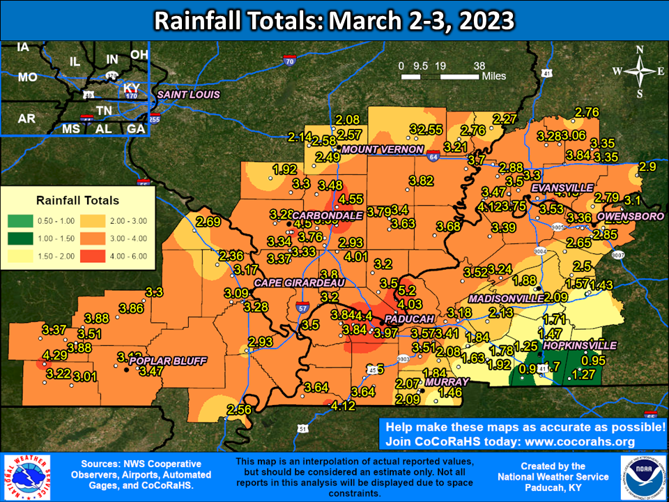 |
| Location | State | County | Source | Rainfall |
| 7 E MIDWAY | IL | POPE | SPOTTER | 5.20 |
| Paducah KY 4.5 SW | KY | McCracken | COCORAHS | 4.74 |
| W.Frankfort | IL | Franklin | CWOP | 4.55 |
| West Paducah 3.1 SSW | KY | McCracken | COCORAHS | 4.54 |
| Carbondale 0.7 W | IL | Jackson | COCORAHS | 4.50 |
| SPILLERTOWN | IL | WILLIAMSON | SPOTTER | 4.50 |
| Paducah KY | KY | McCracken | ASOS | 4.47 |
| West Paducah KY | KY | McCracken | CWOP | 4.40 |
| Benton IL 1 NE | IL | Franklin | COCORAHS | 4.37 |
| Bush IL 2 ESE | IL | Williamson | COCORAHS | 4.37 |
| Doniphan MO 14.5 NW | MO | Ripley | COCORAHS | 4.29 |
| Newburgh 0.3 SE | IN | Warrick | COCORAHS | 4.13 |
| West Paducah KY 2 W | KY | McCracken | COOP | 4.13 |
| Fulton KY 5.0 W | KY | Fulton | COCORAHS | 4.12 |
| Mt. Vernon | IN | Posey | CWOP | 4.12 |
| Mount Vernon IN 10.6 ENE | IN | Posey | COCORAHS | 4.11 |
| Carbondale IL 1.2 W | IL | Jackson | COCORAHS | 4.07 |
| 8 W Evansville | IN | Posey | COCORAHS | 4.05 |
| Brookport IL 7 ENE | IL | Massac | COCORAHS | 4.03 |
| Creal Springs 2.2 W | IL | Williamson | COCORAHS | 4.01 |
| 2 SE EVANSVILLE | IN | VANDERBURGH | COCORAHS | 4.00 |
| Paducah 3.1 SW | KY | McCracken | COCORAHS | 3.97 |
| 2 ESE Eldorado | IL | Saline | COCORAHS | 3.97 |
| Carbondale IL 2.5 W | IL | Jackson | COCORAHS | 3.96 |
| Murphysboro IL 2.8 NNE | IL | Jackson | COCORAHS | 3.93 |
| Ellsinore MO 4.8 WNW | MO | Carter | COCORAHS | 3.88 |
| Mill Spring 1.3 WSW | MO | Wayne | COCORAHS | 3.88 |
| Marion IL 8 SSW | IL | Williamson | COCORAHS | 3.86 |
| 0.7 W Greenville | MO | Wayne | HADS | 3.86 |
| Gage | KY | Ballard | CWOP | 3.84 |
| KEVIL | KY | BALLARD | SPOTTER | 3.84 |
| LYNNVILLE | IN | WARRICK | SPOTTER | 3.84 |
| Mount Vernon 11.0 ENE | IN | Posey | COCORAHS | 3.83 |
| Cape Girardeau MO 1.8 SE | MO | Cape Girardeau | COCORAHS | 3.82 |
| Norris City | IL | Hamilton | COCORAHS | 3.82 |
| Murphysboro IL 1 NW | IL | Jackson | COCORAHS | 3.82 |
| 1 WSW Cypress | IL | Johnson | COCORAHS | 3.80 |
| Harrisburg IL 4.6 NNE | IL | Saline | COCORAHS | 3.79 |
| Crab Orchard IL | IL | Williamson | RAWS | 3.76 |
| 2 WSW EVANSVILLE | IN | VANDERBURGH | COOP | 3.75 |
| Evansville IN | IN | Vanderburgh | ASOS | 3.73 |
| De Soto IL 0.3 ESE | IL | Jackson | COCORAHS | 3.73 |
| Mayfield | KY | Graves | CWOP | 3.71 |
| Crossville IL 3.0 E | IL | White | COCORAHS | 3.70 |
| Junction 1.7 SSE | IL | Gallatin | COCORAHS | 3.68 |
| Cobden IL 4 ENE | IL | Union | COCORAHS | 3.66 |
| Fulton 3.3 NE | KY | Hickman | COCORAHS | 3.64 |
| Hickman KY 2 E | KY | Fulton | KYMN2 | 3.64 |
| HARRISBURG | IL | SALINE | LAW ENFORCEMENT | 3.63 |
| Poseyville IN 2.9 SSE | IN | Posey | COCORAHS | 3.59 |
| Crainville | IL | Williamson | CWOP | 3.59 |
| Grand Rivers 3.9 S | KY | Marshall | COCORAHS | 3.57 |
| Evansville 8.8 WSW | IN | Vanderburgh | COCORAHS | 3.57 |
| Evansville IN 10 NW | IN | Vanderburgh | COCORAHS | 3.57 |
| Benton KY 4 N | KY | Marshall | KYMN2 | 3.55 |
| Henderson KY 5 E | KY | Henderson | KYMN2 | 3.53 |
| Marion KY 4 NE | KY | Crittenden | KYMN2 | 3.52 |
| 1.4 E Benton | KY | Marshall | COOP | 3.51 |
| ELLSINORE | MO | Carter | CWOP | 3.51 |
| Cairo | IL | Alexander | COCORAHS | 3.50 |
| Evansville IN 5.9 WNW | IN | Vanderburgh | COCORAHS | 3.50 |
| Mayfield KY 6 SW | KY | Graves | KYMN2 | 3.50 |
| Shawnee Portable No. 1 | IL | Pope | RAWS | 3.50 |
| Christopher 1.1 NNW | IL | Franklin | COCORAHS | 3.48 |
| Poplar Bluff MO | MO | Butler | ASOS | 3.47 |
| Eddyville 2 NNE | KY | Lyon | COCORAHS | 3.47 |
| Mount Vernon IN | IN | Posey | CWOP | 3.47 |
| IL | IL | Pulaski | COCORAHS | 3.46 |
| 4 S GRAND RIVERS | KY | MARSHALL | SPOTTER | 3.41 |
| Harrisburg IL | IL | Saline | AWOS | 3.40 |
| Evansville 5.4 NNE | IN | Vanderburgh | COCORAHS | 3.40 |
| Morganfield KY 4 E | KY | Union | KYMN2 | 3.39 |
| Makanda 1.5 SSE | IL | Jackson | COCORAHS | 3.37 |
| Chicopee MO | MO | Carter | RAWS | 3.37 |
| Owensboro 4.1 W | KY | Daviess | COCORAHS | 3.36 |
| 2 W OWENSBORO | KY | DAVIESS | SPOTTER | 3.36 |
| Holland IN 6.3 NW | IN | Pike | COCORAHS | 3.35 |
| Stendal IN | IN | Pike | COOP | 3.35 |
| Cobden 4.2 N | IL | Union | COCORAHS | 3.34 |
| Cobden IL 0.8 SSE | IL | Union | COCORAHS | 3.33 |
| Evansville | IN | Vanderburgh | CWOP | 3.32 |
| Evansville 6.7 NW | IN | Vanderburgh | COCORAHS | 3.30 |
| Piedmont MO | MO | Wayne | RAWS | 3.30 |
| DU QUOIN | IL | PERRY | SPOTTER | 3.30 |
| Carbondale IL | IL | Jackson | ASOS | 3.28 |
| Cape Girardeau MO | MO | Scott | ASOS | 3.28 |
| Francisco IN 0.1 SE | IN | Gibson | COCORAHS | 3.28 |
| Providence KY | KY | Webster | COOP | 3.24 |
| Fairdealing MO 6 W | MO | Ripley | COCORAHS | 3.22 |
| Philpot 2.0 S | KY | Daviess | COCORAHS | 3.21 |
| Grayville | IL | White | CWOP | 3.21 |
| Grand Chain Lock and Dam IL | IL | Pulaski | COOP | 3.20 |
| Dixon Springs IL | IL | Pope | RAWS | 3.20 |
| Owensboro 5.9 W | KY | Daviess | COCORAHS | 3.18 |
| Kuttawa 3.4 NW | KY | Lyon | COCORAHS | 3.18 |
| Jackson 2.5 N | MO | Cape Girardeau | COCORAHS | 3.17 |
| Poplar Bluff 3.7 WNW | MO | Butler | COCORAHS | 3.12 |
| Lewisport | KY | Daviess | CWOP | 3.10 |
| 1.5 S Dutchtown | MO | Cape Girardeau | HADS | 3.09 |
| Oakland City IN | IN | Gibson | CWOP | 3.06 |
| Poseyville IN 2.8 NW | IN | Posey | COCORAHS | 3.05 |
| Mount Vernon 5.2 SSW | IL | Jefferson | COCORAHS | 3.04 |
| Doniphan MO | MO | Ripley | RAWS | 3.01 |
| Fairfield IL | IL | Wayne | AWOS | 3.00 |
Environment
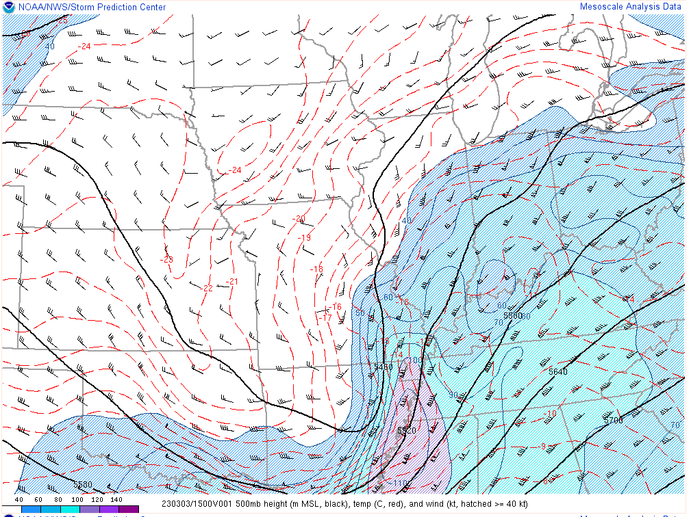
Synoptic environment: Rapidly deepening surface low during the morning and early afternoon of March 3. Meanwhile, negatively tilted 500mb shortwave with 120 knot mid level wind max.
 |
 |
 |
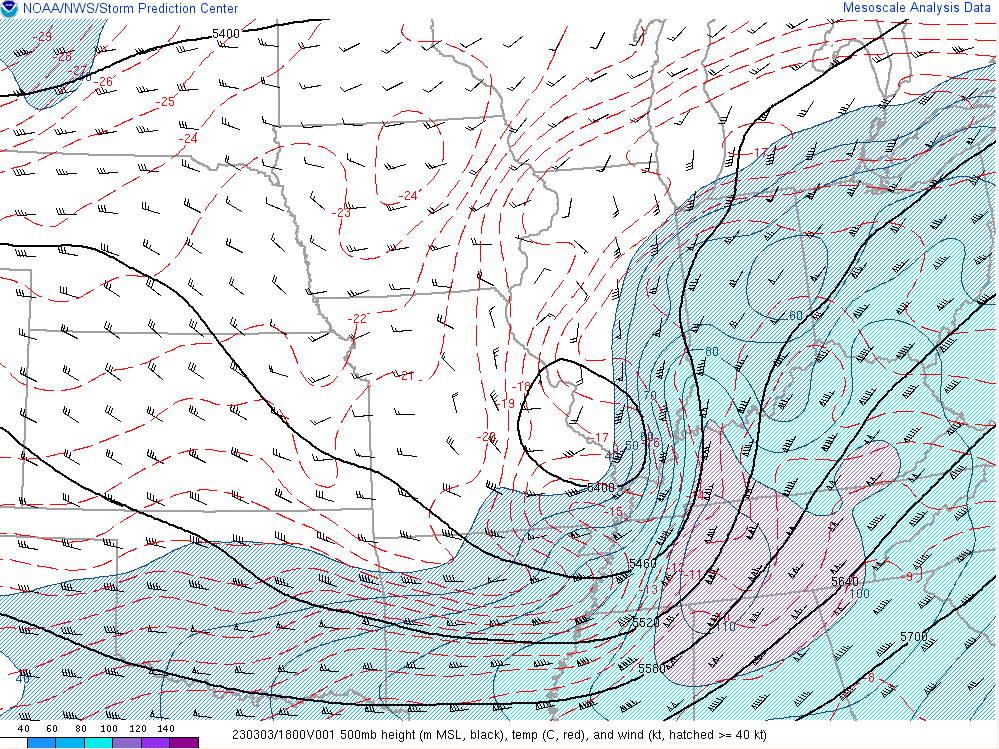 |
| MSLP at 9 AM March 3 | MSLP at 12 PM March 3 | 500mb Chart at 9 AM March 3 | 500mb Chart at 9 AM March 3 |
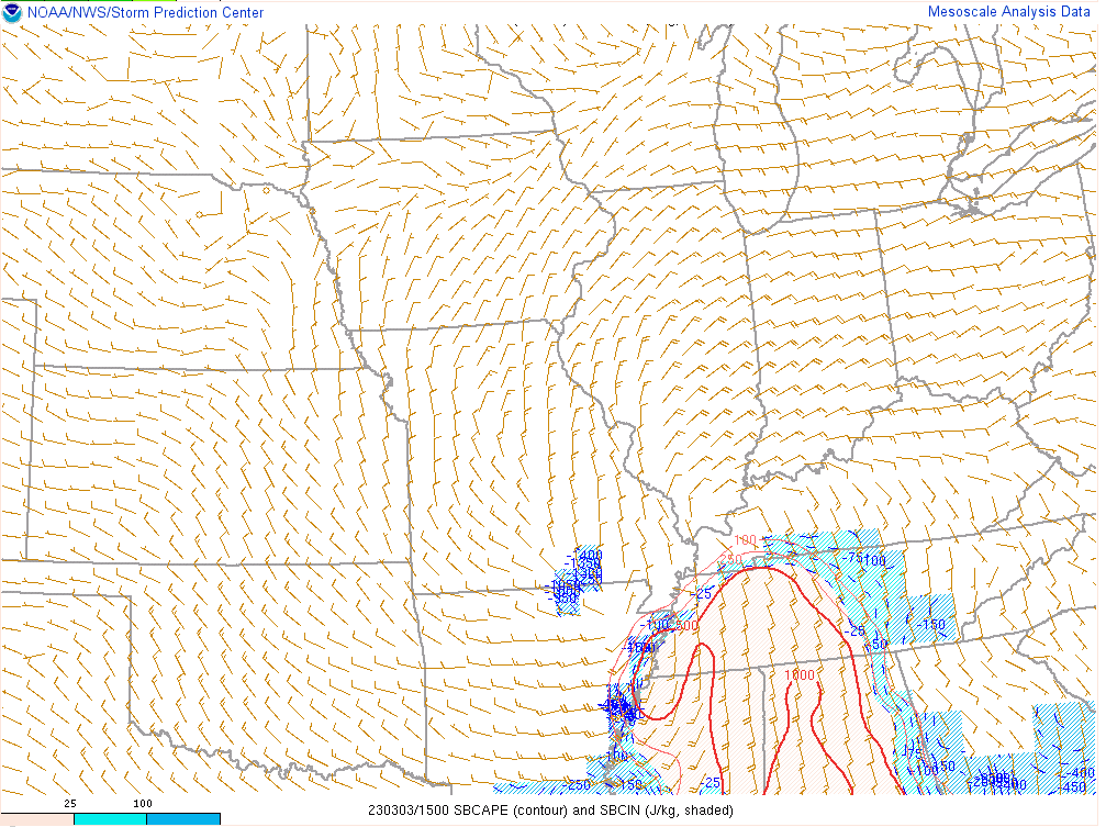
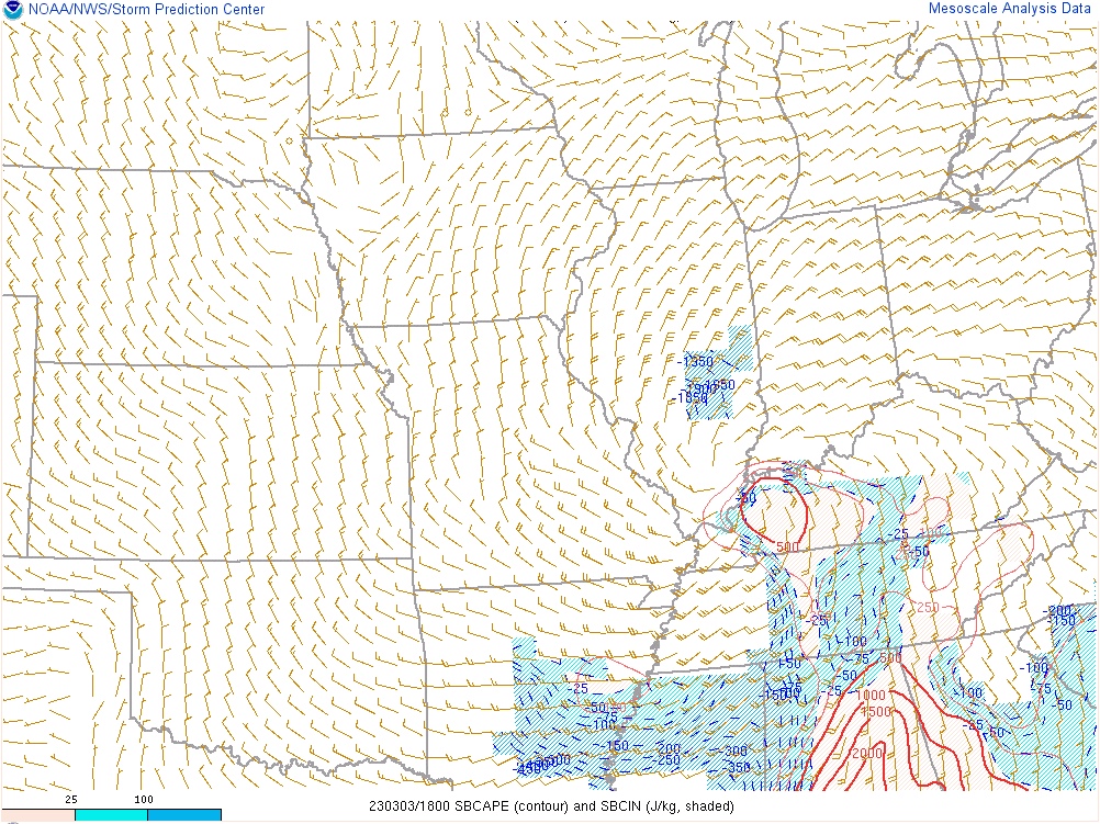
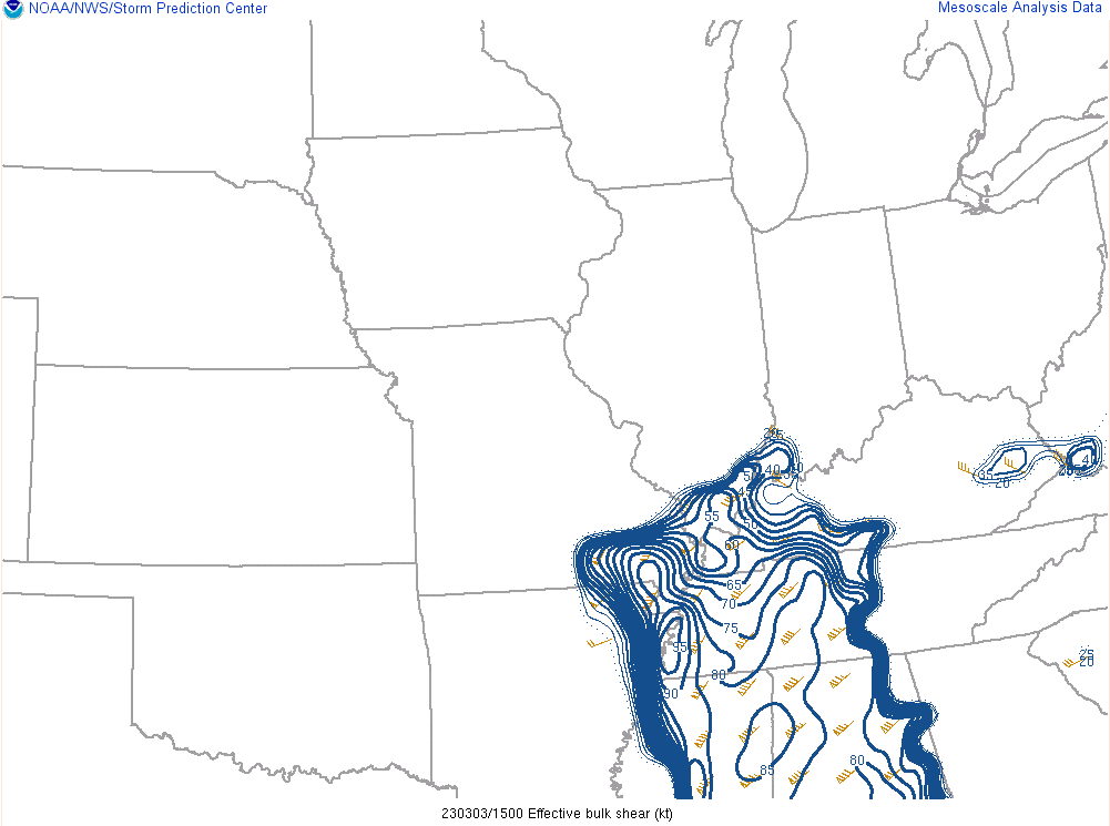
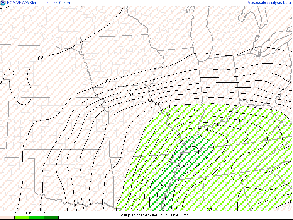
Near-storm environment: As the surface low deepened and moved northeast along the Ohio River, a corridor of 500 J/kg surface based CAPE developed. This helped strengthen the line of storms that moved through during the late morning and midday time frame. Wind shear was off the charts with effective magnitude of 100 knots by Noon across the Pennyrile region of west Kentucky. Precipitable water values of up to 1.6 inches were present leading to very efficient rainfall production from the system.
 |
 |
 |
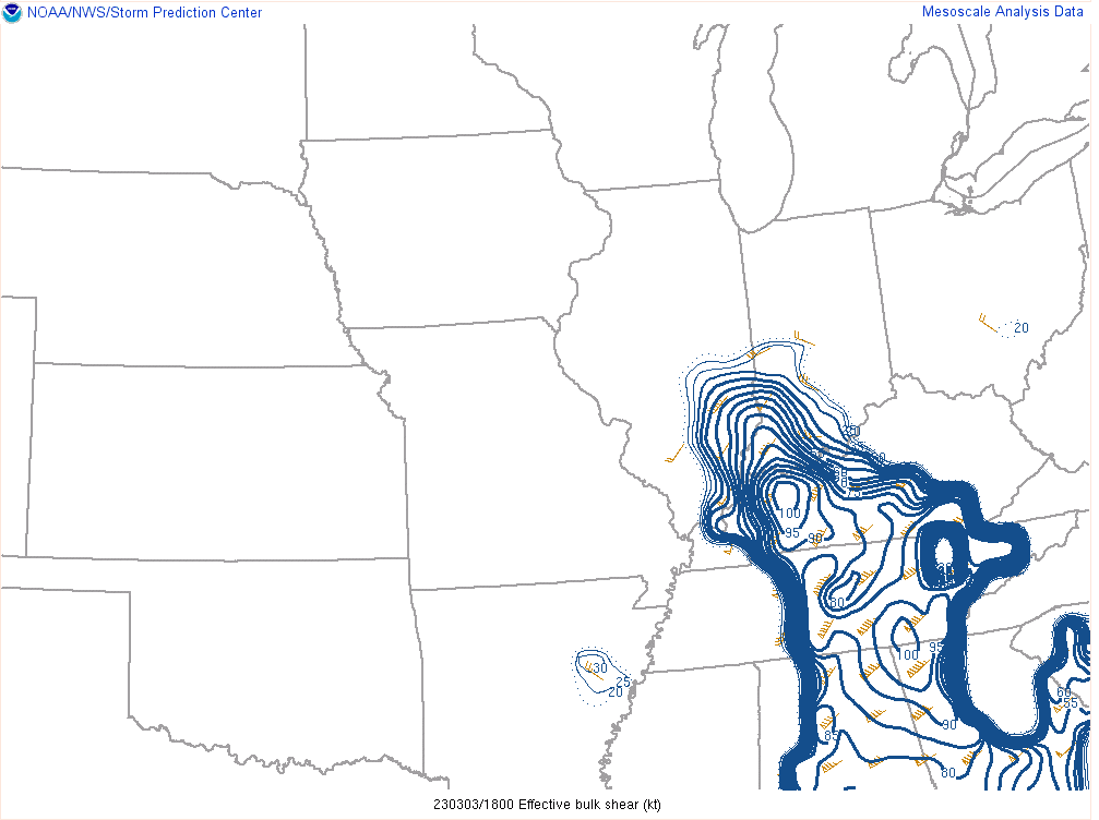 |
| Surface based CAPE at 9 AM March 3 | Surface based CAPE at 12 PM March 3 | Effective Bulk Shear at 9 AM March 3 | Effective Bulk Shear at 12 PM March 3 |
 |
 |
 |
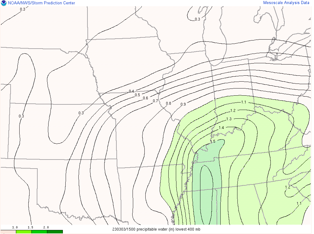 |
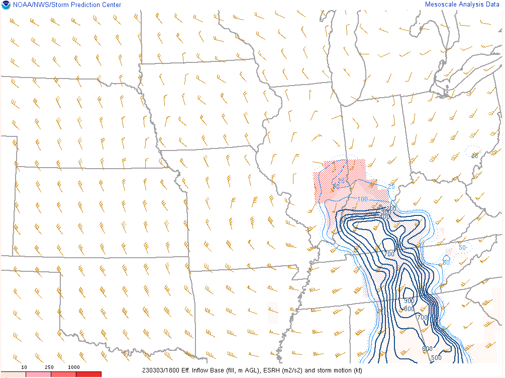
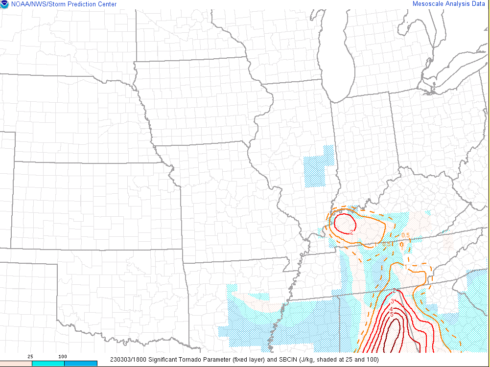
| Effective Storm Relative Helicity (SRH) at 12 PM March 3 | Significant Tornado Parameter (STP) at 12 PM March 3 | Precipitable Water at 6 AM March 3 | Precipitable Water at 9 AM March 3 |
Pressure falls of 8 to 10 mb within a 2 hour period occurred as the surface low lifted northeast out of the region during the afternoon on March 3rd.
 |
 |
| Surface pressure change past 2 hours - 2 PM March 3 | Surface pressure change past 2 hours - 4 PM March 3 |
 |
Media use of NWS Web News Stories is encouraged! Please acknowledge the NWS as the source of any news information accessed from this site. |
|