Overview
Thunderstorm clusters moved east/southeastward across southeast Missouri during the afternoon hours on May 4th, entering Carter and Ripley Counties around 3 PM and exiting into northwest Tennessee by 6 PM. Several areas received extensive wind damage from these storms, including Carter, Ripley, Butler, and New Madrid Counties. Damage surveys confirmed an EF-0 tornado occurred south of Grandin, MO in Carter County. Two macrobursts also occurred with this event, one south of the Grandin, MO tornado in portions of Carter and Ripley Counties and the other in the Gideon, MO area of New Madrid County. The highest winds were associated with the Gideon, MO macroburst with peak winds estimated at 110 mph. Flash flooding also occurred due to repeated thunderstorm activity over Carter and Ripley Counties.
Tornadoes:
|
Tornado - Grandin, Missouri
Track Map 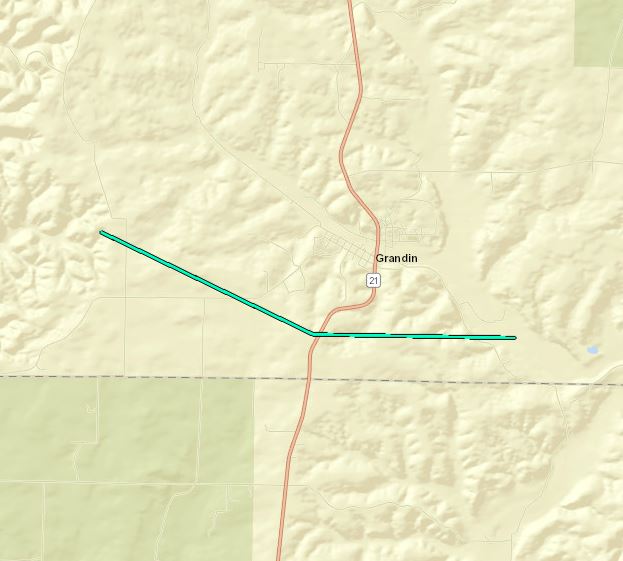 
|
||||||||||||||||
The Enhanced Fujita (EF) Scale classifies tornadoes into the following categories:
| EF0 Weak 65-85 mph |
EF1 Moderate 86-110 mph |
EF2 Significant 111-135 mph |
EF3 Severe 136-165 mph |
EF4 Extreme 166-200 mph |
EF5 Catastrophic 200+ mph |
 |
|||||
Wind:
|
Macroburst - Grandin, Missouri
Track Map 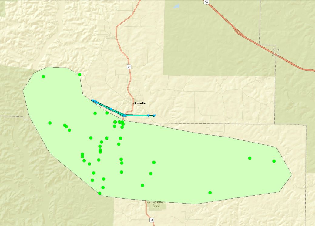 |
||||||||||||||
|
Macroburst - Gideon, Missouri
Track Map 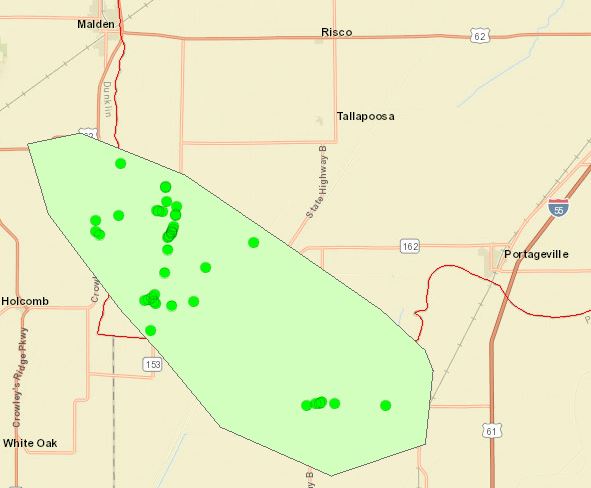
|
||||||||||||||
Photos
 |
 |
 |
 |
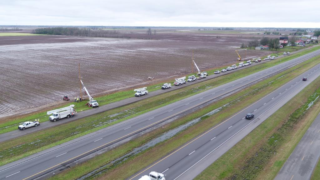
| Damage in Gideon, MO via Highway Patrol | Damage in Gideon, MO via Highway Patrol | Powerlines down 5 miles south of Gideon, MO via Ameren Missouri | Lightning via Mike Hall |
 |
 |
 |
| Damage in Qulin, MO via Derek Masters | Damage in Qulin, MO via Derek Masters | Mammatus clouds at sunset after rain ended at NWS Paducah via Greg Meffert |
Radar
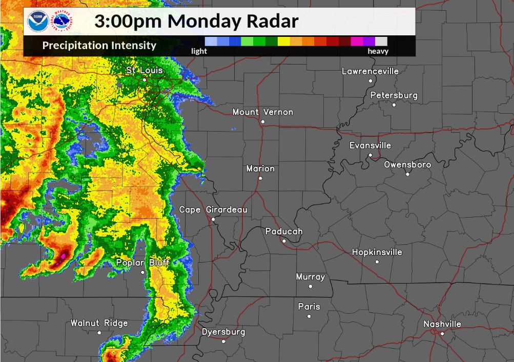
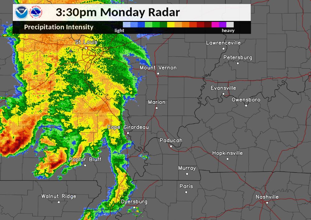
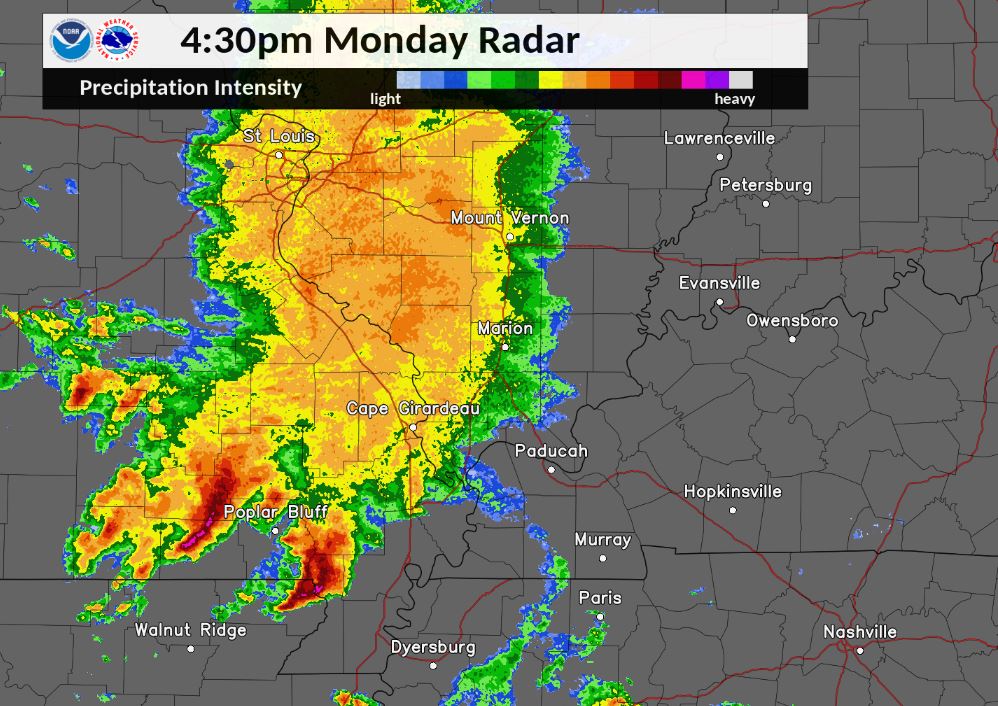
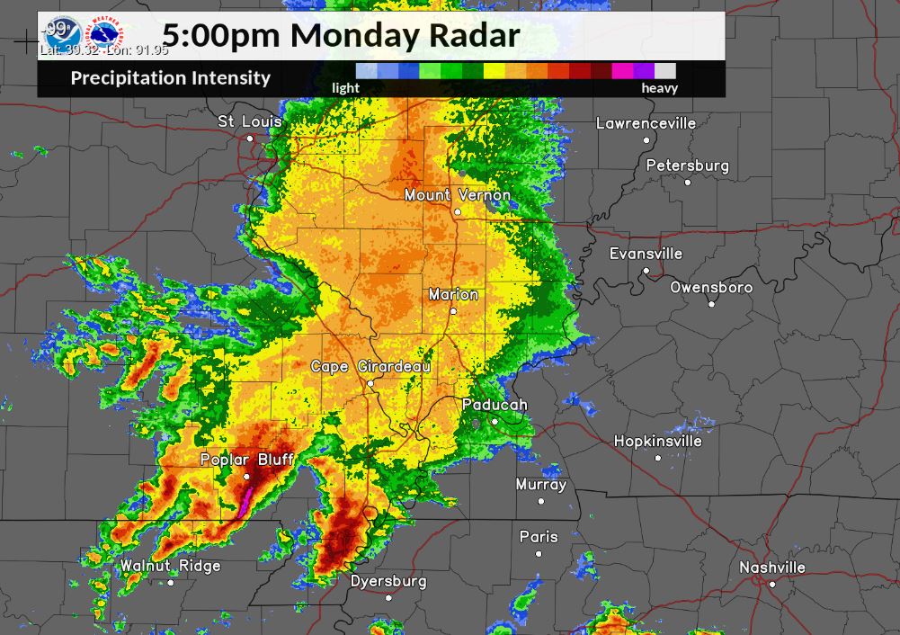
Here are 30 minute snapshots of the thunderstorm clusters from 3 to 5:30 PM as they progressed across southern portions of southeast Missouri before diving southeastward into northwest Tennessee. North of the severe thunderstorms, widespread moderate rain occurred with embedded thunderstorms across much of the area. (Click on the images to enlarge)
 |
 |
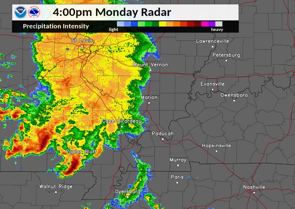 |
| 3 PM Radar Reflectivity | 3:30 PM Radar Reflectivity | 4 PM Radar Reflectivity |
 |
 |
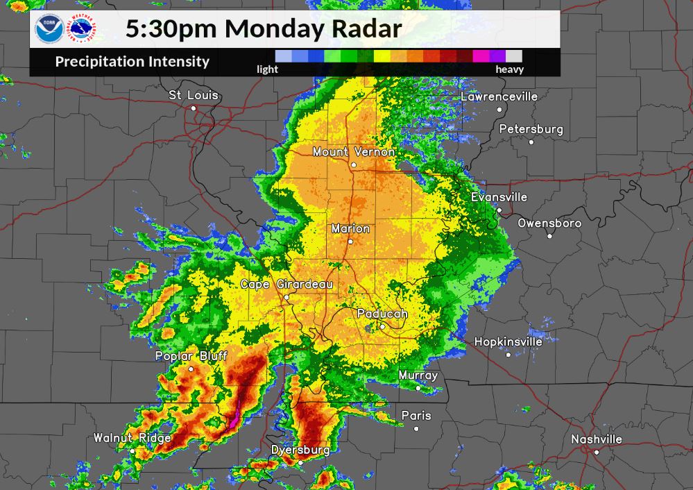 |
| 4:30 PM Radar Reflectivity | 5 PM Radar Reflectivity | 5:30 PM Radar Reflectivity |
Storm Reports
PRELIMINARY LOCAL STORM REPORT...SUMMARY
NATIONAL WEATHER SERVICE PADUCAH KY
647 PM CDT MON MAY 4 2020

..TIME...   ...EVENT...      ...CITY LOCATION...     ...LAT.LON...
..DATE...   ....MAG....      ..COUNTY LOCATION..ST.. ...SOURCE....
            ..REMARKS..

0331 PM     TSTM WND DMG     6 SSW FREEMONT          36.87N 91.19W
05/04/2020                   CARTER             MO   LAW ENFORCEMENT

            TREES DOWN ACROSS J HIGHWAY SIX MILES SOUTH
            OF US 60. TIME ESTIMATED FROM RADAR.

0404 PM     TSTM WND DMG     5 SW CHICOPEE           36.93N 91.06W
05/04/2020                   CARTER             MO   EMERGENCY MNGR

            CORRECTS PREVIOUS TSTM WND DMG REPORT FROM 5
            SW CHICOPEE. TREES DOWN ACROSS C HIGHWAY
            SOUTH OF US 60. CORRECTED TIME.

0405 PM     HAIL             FREEMONT                36.95N 91.16W
05/04/2020  M0.70 INCH       CARTER             MO   EMERGENCY MNGR

            WIND GUSTS UP TO 45 MPH AND POWER OUTAGES
            ALSO REPORTED.

0420 PM     TSTM WND GST     10 W GRANDIN            36.80N 90.99W
05/04/2020  M63 MPH          RIPLEY             MO   PUBLIC

            LARGE TREES UPROOTED AS WELL.

0426 PM     TSTM WND DMG     2 S GRANDIN             36.80N 90.82W
05/04/2020                   RIPLEY             MO   TRAINED SPOTTER

            SEVERE TREES AND POWER LINES DOWN INCLUDING
            A TREE ON A HOUSE.

0426 PM     TSTM WND DMG     1 SW GRANDIN            36.82N 90.83W
05/04/2020                   CARTER             MO   TRAINED SPOTTER

            LARGE TREES DOWN NEAR HIGHWAY 21 SOUTH OF
            GRANDIN IN CARTER COUNTY.

0448 PM     HAIL             2 NNW ROMBAUER          36.87N 90.29W
05/04/2020  E1.00 INCH       BUTLER             MO   TRAINED SPOTTER


0451 PM     HAIL             HARVIELL                36.67N 90.47W
05/04/2020  E1.00 INCH       BUTLER             MO   BROADCAST MEDIA

            BROADCAST MEDIA RELAYED A VIEWER REPORT OF
            ONE INCH HAIL.

0451 PM     TSTM WND GST     HARVIELL                36.66N 90.47W
05/04/2020  E70 MPH          BUTLER             MO   BROADCAST MEDIA

            BROADCAST MEDIA RELAYED A VIEWER REPORT OF
            ESTIMATED 70 MPH WINDS. SEVERAL TREES DOWN
            IN THE AREA. TIME ESTIMATED FROM RADAR.

0451 PM     TSTM WND DMG     HARVIELL                36.66N 90.47W
05/04/2020                   BUTLER             MO   TRAINED SPOTTER

            LARGE TREE DOWN. RELAYED VIA TWITTER.

0500 PM     TSTM WND GST     5 W ASH HILL            36.77N 90.32W
05/04/2020  M58 MPH          BUTLER             MO   ASOS

            ASOS STATION KPOF POPLAR BLUFF MO.

0500 PM     TSTM WND DMG     2 W GLENNONVILLE        36.59N 90.19W
05/04/2020                   BUTLER             MO   EMERGENCY MNGR

            SHOP BUILDING DESTROYED 3 MILES EAST OF
            QULIN, MO IN BUTLER COUNTY.

0505 PM     FLOOD            POPLAR BLUFF            36.77N 90.41W
05/04/2020                   BUTLER             MO   BROADCAST MEDIA

            PONDING OF LOW-LYING STREETS IN POPLAR
            BLUFF.

0512 PM     FLOOD            2 W HARVIELL            36.66N 90.50W
05/04/2020                   BUTLER             MO   TRAINED SPOTTER

            WATER PARTIALLY COVERING ROADS WEST OF
            HARVIELL.

0518 PM     TSTM WND GST     4 SW DEXTER             36.75N 90.01W
05/04/2020  E50 MPH          STODDARD           MO   TRAINED SPOTTER
0525 PM     TSTM WND DMG     GIDEON                  36.45N 89.91W
05/04/2020                   NEW MADRID         MO   EMERGENCY MNGR

            AT LEAST 3 HOMES AND A BUSINESS SUSTAINED MAJOR ROOF
            DAMAGE IN TOWN AND A LARGE FARM BUILDING NEAR HIGHWAY 162
            LOST PORTIONS OF ITS ROOF AND WALLS. POWER LINES WERE
            ALSO BLOWN DOWN.

0525 PM     TSTM WND DMG     GIDEON                  36.45N 89.91W
05/04/2020                   NEW MADRID         MO   EMERGENCY MNGR

            SEVERAL HOMES DAMAGED ON ANDERSON STREET IN
            GIDEON. TIME ESTIMATED BY RADAR.

0600 PM     FLASH FLOOD      3 S GRANDIN             36.79N 90.81W
05/04/2020                   RIPLEY             MO   LAW ENFORCEMENT

            FLOODING ON MANY LOW WATER CROSSINGS IN
            NORTHERN RIPLEY COUNTY.

0600 PM     FLASH FLOOD      3 ESE FREEMONT          36.93N 91.12W
05/04/2020                   CARTER             MO   EMERGENCY MNGR

            NUMEROUS LOW-WATER CROSSINGS FLOODED ACROSS
            THE COUNTY.
Rain Reports
Flash flooding occurred in Ripley and Carter Counties in Missouri due to heavy rainfall from the afternoon storms. Portions of southeast Missouri along the Arkansas border picked up 1 to 2 inches of rain during the afternoon. Another batch of thunderstorms developed overnight producing rainfall totals of 1 to 2 inches across the Wabash River Valley of southeast Illinois into southwest Indiana.
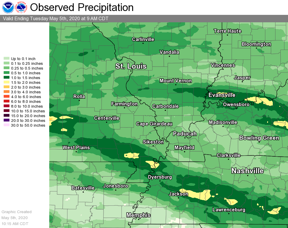 |
PUBLIC INFORMATION STATEMENT
NATIONAL WEATHER SERVICE PADUCAH KY
1008 AM CDT TUE MAY 5 2020

...24 HOUR PRECIPITATION REPORTS ENDING AT 9 AM MAY 5, 2020...

LOCATION                     AMOUNT    TIME/DATE       PROVIDER
DONIPHAN 14.5 NW             2.09 IN   0700 AM 05/05   COCORAHS
NEW HARMONY 1.5 E            1.94 IN   0700 AM 05/05   COCORAHS
POSEYVILLE IN 2.9 SSE        1.89 IN   0700 AM 05/05   COCORAHS
WADESVILLE                   1.80 IN   0952 AM 05/05   CWOP
EVANSVILLE IN 10 NW          1.78 IN   0700 AM 05/05   COCORAHS
POSEYVILLE IN 2.8 NW         1.71 IN   0700 AM 05/05   COCORAHS
SANTA CLAUS IN 1 WSW         1.70 IN   0515 AM 05/05   COCORAHS
EVANSVILLE IN                1.59 IN   0954 AM 05/05   ASOS
BOONVILLE IN 4.5 WSW         1.51 IN   0700 AM 05/05   COCORAHS
1.0 N CARMI                  1.45 IN   0630 AM 05/05   HADS
FAIRDEALING MO 6 W           1.41 IN   0500 AM 05/05   COCORAHS
POPLAR BLUFF MO              1.28 IN   0953 AM 05/05   ASOS
CHICOPEE MO                  1.28 IN   0922 AM 05/05   RAWS
OWENSBORO KY 3 WNW           1.23 IN   0700 AM 05/05   COCORAHS
EVANSVILLE IN 5.9 WNW        1.21 IN   0700 AM 05/05   COCORAHS
DONIPHAN MO                  1.20 IN   0853 AM 05/05   RAWS
2.8 N WALTONVILLE            1.18 IN   0900 AM 05/05   HADS
0.6 NW CHICOPEE              1.16 IN   0830 AM 05/05   HADS
POPLAR BLUFF MO 4 NW         1.15 IN   0845 AM 05/05   COCORAHS
FISK                         1.12 IN   0600 AM 05/05   HADS
EVANSVILLE IN 3.5 ENE        1.10 IN   0800 AM 05/05   COCORAHS
OWENSBORO KY 4.9 S           1.05 IN   0700 AM 05/05   COCORAHS
BELLE RIVE IL 1 NNE          1.02 IN   0638 AM 05/05   COCORAHS
ELLSINORE MO 4.8 WNW         1.01 IN   0700 AM 05/05   COCORAHS
NEWBURGH IN 1.7 ENE          1.00 IN   0800 AM 05/05   COCORAHS
MCLEANSBORO IL 0.8 SSW       0.99 IN   0600 AM 05/05   COCORAHS
2.0 W EVANSVILLE             0.93 IN   0830 AM 05/05   COOP
EVANSVILLE 3.5 ESE           0.93 IN   0730 AM 05/05   COCORAHS
HENDERSON KY 0.4 SSW         0.93 IN   0700 AM 05/05   COCORAHS
OWENSBORO KY                 0.92 IN   0956 AM 05/05   AWOS
SCHELLER                     0.92 IN   0954 AM 05/05   CWOP
NEWBURGH                     0.92 IN   0946 AM 05/05   CWOP
NORRIS CITY, IL 7 NW         0.89 IN   0830 AM 05/05   COCORAHS
NEWBURGH IN                  0.88 IN   0950 AM 05/05   CWOP
EVANSVILLE 4.1 ESE           0.87 IN   0900 AM 05/05   COCORAHS
MOUNT VERNON 5.2 SSW         0.87 IN   0800 AM 05/05   COCORAHS
HENDERSON 5 E                0.85 IN   0950 AM 05/05   KYMN2
DEXTER MO 2 W                0.81 IN   0800 AM 05/05   COCORAHS
DEXTER 0.6 WNW               0.77 IN   0600 AM 05/05   COCORAHS

OBSERVATIONS ARE COLLECTED FROM A VARIETY OF SOURCES WITH VARYING
EQUIPMENT AND EXPOSURES. WE THANK ALL VOLUNTEER WEATHER OBSERVERS
FOR THEIR DEDICATION. NOT ALL DATA LISTED ARE CONSIDERED OFFICIAL.
 |
Media use of NWS Web News Stories is encouraged! Please acknowledge the NWS as the source of any news information accessed from this site. |
|

