October 2025 Climate Review:
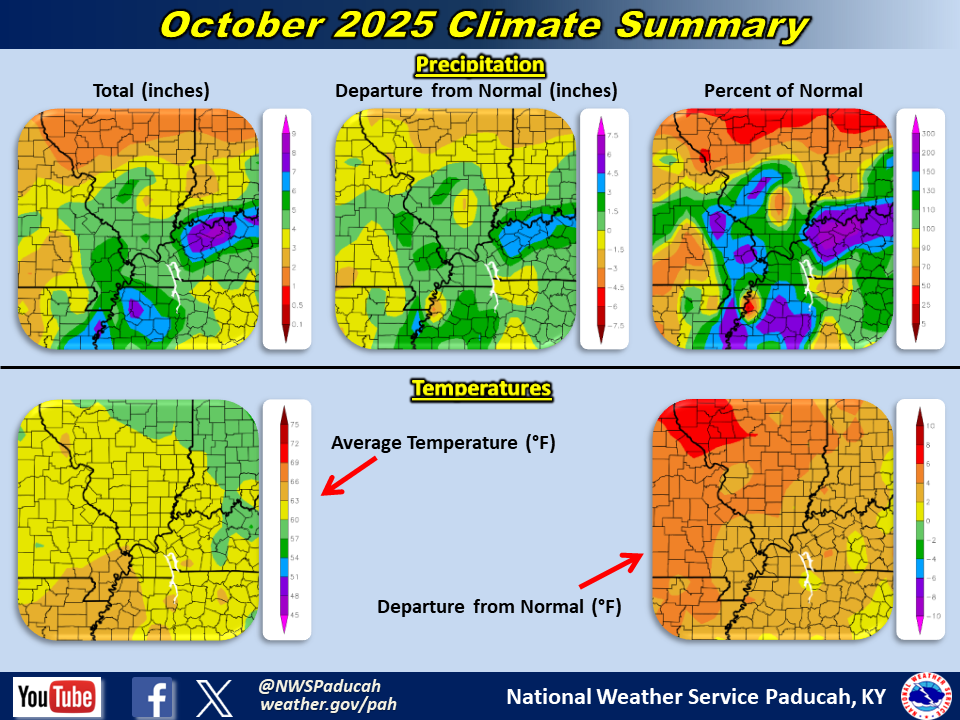
Temperatures averaged above normal by 2 to 4 degrees. The majority of the first 18 days of the month were warmer than normal, with many days in the 80s for highs. There was a short-lived cool down from the 8th through 10th. A pattern flip occurred during the latter half of the month, with temperatures primarily below normal from the 19th onward. Highs were primarily in the 50s or 60s during this period, with the chilliest stretch occurring from the 26th through 29th. While a few frosty mornings were realized, most locations didn’t register their first freeze yet.
October was a wet month across our region with most areas finishing wetter than normal. The only exceptions were portions of the Ozark Foothills of Missouri and a few areas north of the I-64 corridor in southern Illinois and southwest Indiana which finished near or a bit drier than normal. Amounts over much of the region ranged from 4 to 8 inches which was 1 to 4 inches wetter than normal. The highest observed total was 8.94” at a CoCoRaHS station in Daviess County Kentucky (Owensboro 4.4 ESE). Moderate to severe drought conditions were in place across a decent portion of the region at the beginning of the month, but then were mostly wiped out by the wetter pattern that took over.
The graphic below is an interpolated monthly rainfall map using actual observations. Please note that there are likely discrepancies in between observations, since the values are estimated based on nearest reports.

| October 2025 Review: Precipitation and Temperature Maps (Click on image to enlarge) |
 |
| Climate Maps are from the Northeast Regional Climate Center |
After enduring one of our wettest starts to the year on record (January through July), the faucet turned off and we experienced one of our driest August's on record!

Monthly Climate Report: Paducah | Evansville | Cape Girardeau | Poplar Bluff | Carbondale