The graphic below shows observed snowfall totals, along with estimated snowfall amounts in-between actual observations. There is a table located below the map, that shows the amount and location of snowfall totals.
Click here for a summary of the event
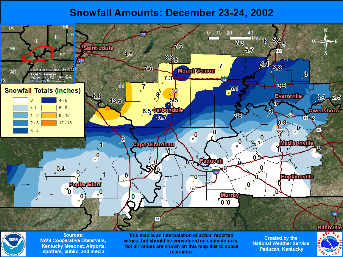
| State | Location | Type | County | Snow |
| IL | REND LAKE DAM | COOP | Franklin | 10 |
| IL | DU QUOIN 4 SE | COOP | Perry | 8 |
| IL | WALTONVILLE | COOP | Jefferson | 7.3 |
| IL | PINCKNEYVILLE 2 N | COOP | Perry | 7 |
| IL | FAIRFIELD RADIO WFIW | COOP | Wayne | 7 |
| IL | MURPHYSBORO 2 SW | COOP | Jackson | 6.5 |
| IL | CARMI 3 | COOP | White | 6.1 |
| IL | DIX | COOP | Jefferson | 6 |
| IL | CARBONDALE SEWAGE PLT | COOP | Jackson | 5.7 |
| IL | PLUMFIELD | COOP | Franklin | 5.5 |
| IL | MT VERNON 3 NE | COOP | Jefferson | 4.1 |
| IL | MT CARMEL | COOP | Wabash | 4.1 |
| IN | PRINCETON 1 W | COOP | Gibson | 3.8 |
| IN | MCCUTCHANVILLE 4 N | COOP | Vanderburgh | 3.8 |
| IN | GRANDVIEW | COOP | Spencer | 3.4 |
| IN | BOONVILLE 1 S | COOP | Warrick | 3.3 |
| IN | STENDAL | COOP | Pike | 3 |
| IN | EVANSVILLE MUSEUM | COOP | Vanderburgh | 3 |
| KY | HENDERSON 8 SSW | COOP | Henderson | 3 |
| IN | EVANSVILLE REGIONAL AP | WBAN | Vanderburgh | 2.9 |
| IL | SHAWNEETOWN OLD TOWN | COOP | Gallatin | 2.8 |
| KY | OWENSBORO 3E | COOP | Daviess | 2 |
| MO | JACKSON | COOP | Cape Girardeau | 2 |
| MO | DONIPHAN | COOP | Ripley | 1 |
| MO | BLOOMFIELD | COOP | Stoddard | 1 |
| MO | MARBLE HILL | COOP | Bollinger | 1 |
| IL | BROOKPORT DAM 52 | COOP | Massac | 1 |
| KY | SEBREE 1 E | COOP | Webster | 0.8 |
| MO | WILLIAMSVILLE | COOP | Wayne | 0.4 |
| KY | PADUCAH BARKLEY RGNL AP | WBAN | McCracken | 0.3 |

