The graphic below shows observed snowfall totals, along with estimated snowfall amounts in-between actual observations. There is a table located below the map, that shows the amount and location of snowfall totals.
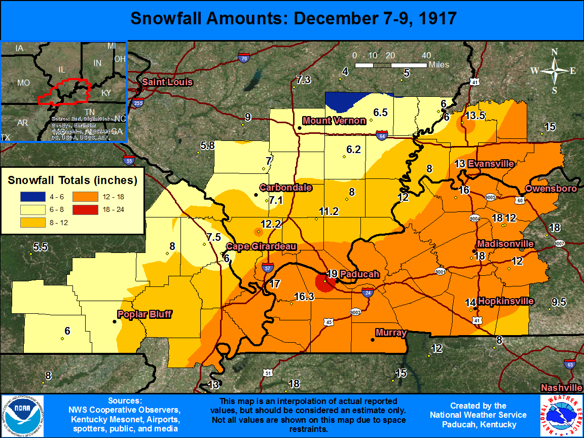
| State | Location | Type | County | Snow |
| KY | PADUCAH LONE OAKS | COOP | McCracken | 19 |
| KY | EARLINGTON | COOP | Hopkins | 18 |
| KY | CALHOUN (1) | COOP | McLean | 18 |
| IL | CAIRO | WBAN | Alexander | 17 |
| KY | BLANDVILLE | COOP | Ballard | 16.3 |
| KY | HENDERSON 8 SSW | COOP | Henderson | 16 |
| KY | HOPKINSVILLE | COOP | Christian | 14 |
| IN | PRINCETON 1 W | COOP | Gibson | 13.5 |
| IN | EVANSVILLE FT COUR | COOP | Vanderburgh | 13 |
| IL | ANNA | COOP | Union | 12.2 |
| IL | SHAWNEETOWN OLD TOWN | COOP | Gallatin | 12 |
| KY | GREENVILLE 2 W | COOP | Muhlenberg | 12 |
| KY | CALHOUN LOCK 2 | COOP | McLean | 12 |
| IL | NEW BURNSIDE | COOP | Johnson | 11.2 |
| MO | MARBLE HILL | COOP | Bollinger | 8 |
| IL | HARRISBURG | COOP | Saline | 8 |
| IN | MT VERNON | COOP | Posey | 8 |
| MO | JACKSON | COOP | Cape Girardeau | 7.5 |
| IL | CARBONDALE SEWAGE PLT | COOP | Jackson | 7.1 |
| IL | DU QUOIN 4 SE | COOP | Perry | 7 |
| IL | FAIRFIELD RADIO WFIW | COOP | Wayne | 6.5 |
| IL | MCLEANSBORO | COOP | Hamilton | 6.2 |
| MO | DONIPHAN | COOP | Ripley | 6 |
| MO | CAPE GIRARDEAU | COOP | Cape Girardeau | 6 |
| IL | MT VERNON 3 NE | COOP | Jefferson | 6 |
| IL | MT CARMEL | COOP | Wabash | 6 |
| IL | MT CARMEL 4 NW | COOP | Wabash | 6 |

