Overview
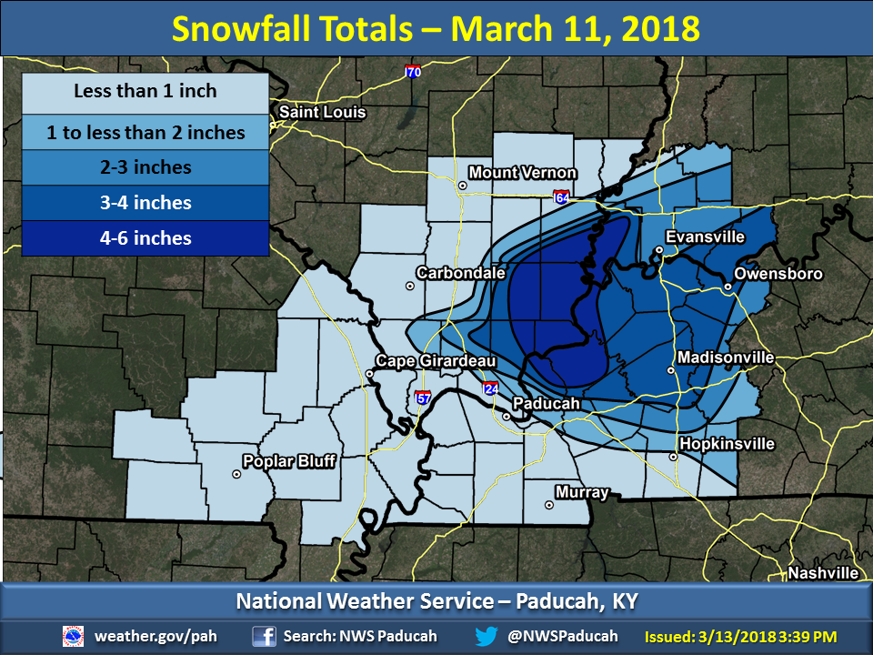
A mid/upper level low passed by just to the southeast of the forecast area on March 11th with a deformation band forming across our region. Colder air began to funnel into the area during the afternoon hours changing the rain to snow rather quickly from northwest to southeast. This was a difficult event to forecast for due to the warm ground and air temperatures at or above freezing. Thus, the snow had a hard time sticking in places that it didn’t come down hard enough. This was especially true for the Jackson Purchase area of western Kentucky from the Mississippi River to the Lakes Region. Amounts of 2 to 4 inches were common across southeast Illinois into northwest Kentucky and southwest Indiana. There was even a narrow area of 4 to 6 inches.Snow
The graphic below shows snowfall totals for this event. This map is based on observed reports we received and is interpolated in between those observations. The heaviest amounts were confined to portions of far southeast Illinois into far northwest Kentucky and southwest Indiana where amounts up around 4 inches were common, and in some spots up to 6 inches!
 |
Radar:
Here is a radar loop from 1 PM Sunday March 11th through 3 AM Monday March 12th.
Storm Reports
PRELIMINARY LOCAL STORM REPORT...SUMMARY
NATIONAL WEATHER SERVICE PADUCAH KY
146 PM CDT MON MAR 12 2018

..TIME...   ...EVENT...      ...CITY LOCATION...     ...LAT.LON...
..DATE...   ....MAG....      ..COUNTY LOCATION..ST.. ...SOURCE....
            ..REMARKS..

0458 PM     SNOW             EVANSVILLE              37.98N 87.54W
03/11/2018  M1.0 INCH        VANDERBURGH        IN   CO-OP OBSERVER

            SNOW ACCUMULATION THROUGH 5 PM CDT. REPORT RELAYED BY THE
            EVANSVILLE INDIANA AIRPORT FIRE DEPARTMENT.

0515 PM     SNOW             SMITHLAND               37.14N 88.40W
03/11/2018  E1.5 INCH        LIVINGSTON         KY   PUBLIC

            ALL SURFACES COVERED WITH SNOW. PUBLIC REPORT RELAYED BY
            BEAU DODSON.

0530 PM     SNOW             EVANSVILLE              37.98N 87.54W
03/11/2018  M1.0 INCH        VANDERBURGH        IN   TRAINED SPOTTER

            SNOWFALL AS OF 530 PM CDT. HEAVY SNOW STILL BEING
            REPORTED. SNOW ON VEHICLES AND ROADS ARE SLUSHY. REPORT
            FROM SOUTHEAST EVANSVILLE...ANGEL MOUNDS AREA.

0545 PM     SNOW             EVANSVILLE              37.98N 87.54W
03/11/2018  M1.8 INCH        VANDERBURGH        IN   CO-OP OBSERVER

            SNOWFALL ACCUMULATION AS OF 545 PM CDT. AN INCREASE OF
            0.8 INCHES TO SNOWFALL TOTAL IN LAST 45 MINUTES. REPORT
            RELAYED BY EVANSVILLE AIRPORT FIRE DEPARTMENT.

0600 PM     SNOW             HARRISBURG              37.74N 88.55W
03/11/2018  M2.8 INCH        SALINE             IL   PUBLIC

            SNOWFALL AMOUNT AS OF 6 PM CDT. REPORT RELAYED BY BEAU
            DODSON.

0615 PM     SNOW             13 SE HARRISBURG        37.60N 88.38W
03/11/2018  M3.0 INCH        SALINE             IL   TRAINED SPOTTER

            SNOWFALL SO FAR NEAR SOMERSET ROAD, JUST NORTH OF THE
            SHAWNEE NATIONAL FOREST AND THE BORDER WITH POPE COUNTY
            ILLINOIS.

0615 PM     SNOW             W MCCUTCHANVILLE        38.06N 87.52W
03/11/2018  M2.0 INCH        VANDERBURGH        IN   BROADCAST MEDIA

            SNOWFALL AS OF 6 PM CDT. REPORT RELAYED BY WEVV-TV
            METEOROLOGIST.

0630 PM     SNOW             MORGANFIELD             37.68N 87.91W
03/11/2018  M2.5 INCH        UNION              KY   PUBLIC

            PUBLIC REPORT VIA SOCIAL MEDIA.

0640 PM     SNOW             STURGIS                 37.55N 87.99W
03/11/2018  M3.0 INCH        UNION              KY   PUBLIC

0640 PM     SNOW             SHAWNEETOWN             37.71N 88.17W
03/11/2018  M4.5 INCH        GALLATIN           IL   PUBLIC

            RELAYED VIA TWITTER.

0700 PM     SNOW             EVANSVILLE              37.98N 87.54W
03/11/2018  M2.8 INCH        VANDERBURGH        IN   TRAINED SPOTTER

            ANGEL MOUNDS AREA. SOME TREE LIMBS BROKEN AND SOME POWER
            LINES ARE SAGGING IN NEIGHBORHOOD.

0700 PM     SNOW             KUTTAWA                 37.06N 88.11W
03/11/2018  M2.0 INCH        LYON               KY   TRAINED SPOTTER

            AS OF 7 PM CDT. REPORT RELAYED FROM BEAU DODSON.

0700 PM     SNOW             2 SW KARBERS RIDGE      37.56N 88.36W
03/11/2018  E4.0 INCH        HARDIN             IL   PUBLIC

            REPORT FROM SOCIAL MEDIA.

0700 PM     SNOW             ONTON                   37.56N 87.44W
03/11/2018  M2.0 INCH        WEBSTER            KY   TRAINED SPOTTER

            REPORT RELAYED BY BEAU DODSON.

0730 PM     SNOW             ROCKPORT                37.88N 87.05W
03/11/2018  M2.0 INCH        SPENCER            IN   TRAINED SPOTTER

            SPOTTER REPORTS MAIN ROADS ARE FAIR, BUT SIDE ROADS ARE
            BECOMING SLUSHY AND SNOW COVERED. MODERATE SNOW
            CONTINUES.

0750 PM     SNOW             W MCCUTCHANVILLE        38.06N 87.52W
03/11/2018  M2.3 INCH        VANDERBURGH        IN   BROADCAST MEDIA

            UPDATED SNOWFALL TOTAL. LIGHT SNOW STILL FALLING.

0804 PM     SNOW             MARION                  37.33N 88.08W
03/11/2018  E3.5 INCH        CRITTENDEN         KY   PUBLIC

            REPORT RELAYED FROM BEAU DODSON.

0900 PM     SNOW             HERALD                  37.97N 88.17W
03/11/2018  E6.0 INCH        WHITE              IL   PUBLIC

            ESTIMATED 6 INCHES OF SNOW.

0930 PM     SNOW             3 E NORRIS CITY         37.98N 88.27W
03/11/2018  M4.1 INCH        WHITE              IL   PUBLIC

            TREE LIMBS DOWN. ROADS IN POOR CONDITION. RECEIVED VIA
            SOCIAL MEDIA.

0940 PM     SNOW             MACEO                   37.86N 86.99W
03/11/2018  M2.5 INCH        DAVIESS            KY   PUBLIC

            REPORT FROM SOCIAL MEDIA.

0945 PM     SNOW             EDDYVILLE               37.08N 88.08W
03/11/2018  M0.8 INCH        LYON               KY   TRAINED SPOTTER

            RELAYED VIA TWITTER.

0950 PM     SNOW             SAVAH                   38.02N 87.98W
03/11/2018  E3.0 INCH        POSEY              IN   PUBLIC

            REPORT FROM SOCIAL MEDIA.

0955 PM     SNOW             HARRISBURG              37.74N 88.55W
03/11/2018  M3.2 INCH        SALINE             IL   LAW ENFORCEMENT

            MEASURED ON THE SOUTHWEST SIDE OF HARRISBURG.

1021 PM     SNOW             OWENSBORO               37.76N 87.12W
03/11/2018  M2.5 INCH        DAVIESS            KY   PUBLIC

1021 PM     SNOW             OWENSBORO               37.76N 87.12W
03/11/2018  E3.0 INCH        DAVIESS            KY   PUBLIC

1022 PM     SNOW             N MADISONVILLE          37.34N 87.51W
03/11/2018  E1.0 INCH        HOPKINS            KY   PUBLIC

1048 PM     SNOW             BOONVILLE               38.05N 87.27W
03/11/2018  M2.8 INCH        WARRICK            IN   PUBLIC

            STORM TOTAL SNOW. REPORT FROM SOCIAL MEDIA.

1115 PM     SNOW             2 SW SHAWNEETOWN        37.69N 88.19W
03/11/2018  E5.0 INCH        GALLATIN           IL   PUBLIC

            RELAYED FROM SOCIAL MEDIA.

1130 PM     SNOW             6 SSW GREENVILLE        37.13N 87.22W
03/11/2018  M2.0 INCH        MUHLENBERG         KY   EMERGENCY MNGR

            HEAVY SNOW STILL FALLING.

0101 AM     SNOW             MURRAY                  36.61N 88.32W
03/12/2018  M0.3 INCH        CALLOWAY           KY   CO-OP OBSERVER

            STORM TOTAL.

0130 AM     SNOW             13 SE HARRISBURG        37.60N 88.38W
03/12/2018  M4.0 INCH        SALINE             IL   TRAINED SPOTTER

            FINAL SNOWFALL TOTAL NEAR SOMERSET ROAD, JUST NORTH OF
            THE SHAWNEE NATIONAL FOREST AND THE BORDER WITH POPE
            COUNTY ILLINOIS.

0130 AM     SNOW             EICHORN                 37.49N 88.41W
03/12/2018  M5.0 INCH        HARDIN             IL   TRAINED SPOTTER

            STORM TOTAL.

0600 AM     SNOW             4 NNE EVANSVILLE        38.04N 87.52W
03/12/2018  M2.0 INCH        VANDERBURGH        IN   TRAINED SPOTTER

            OFFICIAL STORM TOTAL SNOWFALL AT EVANSVILLE AIRPORT

0800 AM     SNOW             KUTTAWA                 37.06N 88.11W
03/12/2018  E2.0 INCH        LYON               KY   PUBLIC

            SNOWFALL TOTAL RELAYED VIA FACEBOOK

0800 AM     SNOW             WHITESVILLE             37.68N 86.87W
03/12/2018  E4.2 INCH        DAVIESS            KY   PUBLIC

            SNOWFALL TOTAL RELAYED VIA FACEBOOK

0800 AM     SNOW             LEVIAS                  37.31N 88.18W
03/12/2018  E6.0 INCH        CRITTENDEN         KY   PUBLIC

            SNOWFALL TOTAL.

0800 AM     SNOW             6 SSW GREENVILLE        37.13N 87.22W
03/12/2018  M4.0 INCH        MUHLENBERG         KY   EMERGENCY MNGR

            SNOWFALL TOTAL

0800 AM     SNOW             CAVE-IN-ROCK            37.47N 88.17W
03/12/2018  E4.0 INCH        HARDIN             IL   PUBLIC

            SNOWFALL TOTAL

0800 AM     SNOW             WADESVILLE              38.10N 87.79W
03/12/2018  E4.0 INCH        POSEY              IN   PUBLIC

            SNOWFALL TOTAL

0800 AM     SNOW             4 S NEW HARMONY         38.07N 87.93W
03/12/2018  E4.0 INCH        POSEY              IN   PUBLIC

            SNOWFALL TOTAL

0800 AM     SNOW             MADISONVILLE            37.34N 87.51W
03/12/2018  E2.0 INCH        HOPKINS            KY   PUBLIC

            SNOWFALL TOTAL

0800 AM     SNOW             FRANCISCO               38.33N 87.45W
03/12/2018  M1.0 INCH        GIBSON             IN   COCORAHS

            SNOWFALL TOTAL

0800 AM     SNOW             6 NW HOLLAND            38.31N 87.12W
03/12/2018  M2.0 INCH        PIKE               IN   COCORAHS

            SNOWFALL TOTAL

0800 AM     SNOW             1 SW SANTA CLAUS        38.11N 86.94W
03/12/2018  M3.2 INCH        SPENCER            IN   COCORAHS

            SNOWFALL TOTAL

0800 AM     SNOW             2 NNE EDDYVILLE         37.10N 88.07W
03/12/2018  M1.8 INCH        LYON               KY   COCORAHS

            SNOWFALL TOTAL

0800 AM     SNOW             3 NW OWENSBORO          37.79N 87.16W
03/12/2018  M4.2 INCH        DAVIESS            KY   COCORAHS

            SNOWFALL TOTAL

0800 AM     SNOW             SALEM                   37.27N 88.24W
03/12/2018  M2.3 INCH        LIVINGSTON         KY   COCORAHS

            SNOWFALL TOTAL
 |
Media use of NWS Web News Stories is encouraged! Please acknowledge the NWS as the source of any news information accessed from this site. |
|

