The graphic below shows observed snowfall totals, along with estimated snowfall amounts in-between actual observations. There is a table located below the map, that shows the amount and location of snowfall totals.
Click here for a summary for this event
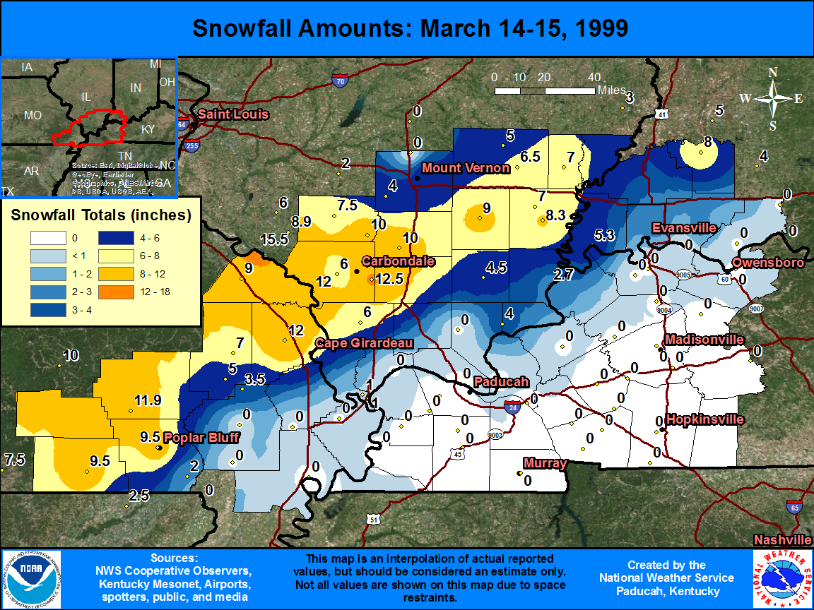
| State | Location | Type | County | Snow |
| IL | CARBONDALE SEWAGE PLT | COOP | Jackson | 12.5 |
| IL | GRAND TWR 2 N | COOP | Jackson | 12 |
| MO | JACKSON | COOP | Cape Girardeau | 12 |
| MO | WILLIAMSVILLE | COOP | Wayne | 11.9 |
| IL | PLUMFIELD | COOP | Franklin | 10 |
| IL | DU QUOIN 4 SE | COOP | Perry | 10 |
| MO | DONIPHAN | COOP | Ripley | 9.5 |
| MO | POPLAR BLUFF | COOP | Butler | 9.5 |
| MO | PERRYVILLE WATR PLT | COOP | Perry | 9 |
| IL | MCLEANSBORO | COOP | Hamilton | 9 |
| IL | CARMI 3 | COOP | White | 8.3 |
| IN | PETERSBURG 61 BRG | COOP | Pike | 8 |
| IL | PINCKNEYVILLE 2 N | COOP | Perry | 7.5 |
| MO | MARBLE HILL | COOP | Bollinger | 7 |
| IL | CARMI 6 NW | COOP | White | 7 |
| IL | ALBION | COOP | Edwards | 7 |
| IL | FAIRFIELD RADIO WFIW | COOP | Wayne | 6.5 |
| IL | MURPHYSBORO 2 SW | COOP | Jackson | 6 |
| IL | ANNA | COOP | Union | 6 |
| IN | MT VERNON | COOP | Posey | 5.3 |
| MO | ZALMA 4 E | COOP | Bollinger | 5 |
| IL | MT VERNON 3 NE | COOP | Jefferson | 5 |
| IL | CISNE 2 S | COOP | Wayne | 5 |
| IL | HARRISBURG | COOP | Saline | 4.5 |
| IL | WALTONVILLE | COOP | Jefferson | 4 |
| IL | ROSICLARE 5 NW | COOP | Hardin | 4 |
| MO | ADVANCE 1 S | WBAN | Stoddard | 3.5 |
| IN | EVANSVILLE REGIONAL AP | WBAN | Vanderburgh | 2.8 |
| IL | SHAWNEETOWN OLD TOWN | COOP | Gallatin | 2.7 |
| IN | BOONVILLE 1 S | COOP | Warrick | 2.5 |
| MO | QULIN | COOP | Butler | 2 |
| IL | CAIRO 3 N | COOP | Alexander | 1 |
| IL | CAIRO RGNL AP | WBAN | Alexander | 1 |

