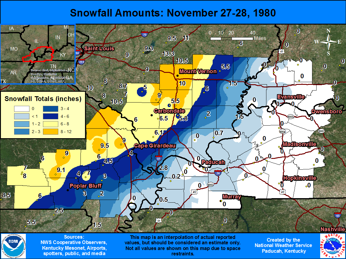
The graphic below shows observed snowfall totals, along with estimated snowfall amounts in-between actual observations. There is a table located below the map, that shows the amount and location of snowfall totals.
| State | Location | Type | County | Snow |
| IL | WEST FRANKFORT | COOP | Franklin | 11.2 |
| IL | DIX | COOP | Jefferson | 10.5 |
| IL | INA | COOP | Jefferson | 10 |
| MO | MARBLE HILL | COOP | Bollinger | 9.5 |
| MO | WILLIAMSVILLE | COOP | Wayne | 9.1 |
| MO | GREENVILLE 6 N | COOP | Wayne | 9 |
| MO | JACKSON | COOP | Cape Girardeau | 9 |
| IL | DU QUOIN 4 SE | COOP | Perry | 9 |
| MO | VAN BUREN RS | COOP | Carter | 8 |
| MO | VAN BUREN | COOP | Carter | 7 |
| MO | PUXICO 1 SE | COOP | Stoddard | 7 |
| IL | CARBONDALE SEWAGE PLT | COOP | Jackson | 6.5 |
| IL | ANNA | COOP | Union | 6.1 |
| MO | DONIPHAN | COOP | Ripley | 6 |
| MO | CLEARWATER DAM | COOP | Wayne | 6 |
| MO | ZALMA 4 E | COOP | Bollinger | 6 |
| IL | GRAND TWR 2 N | COOP | Jackson | 6 |
| IL | MCLEANSBORO | COOP | Hamilton | 6 |
| IL | MARION 4 NNE | COOP | Williamson | 5.8 |
| IL | PLUMFIELD | COOP | Franklin | 5.5 |
| IL | FAIRFIELD RADIO WFIW | COOP | Wayne | 5.5 |
| IL | PINCKNEYVILLE 2 N | COOP | Perry | 5 |
| MO | ADVANCE 1 S | WBAN | Stoddard | 4.5 |
| MO | WAPPAPELLO DAM | COOP | Wayne | 4 |
| MO | CAPE GIRARDEAU MUNI AP | WBAN | Scott | 4 |
| MO | FISK | COOP | Stoddard | 3 |
| MO | BLOOMFIELD | COOP | Stoddard | 3 |
| IL | CAIRO | WBAN | Alexander | 2.8 |
| MO | BERNIE | COOP | Stoddard | 2 |
| IL | HARRISBURG | COOP | Saline | 2 |
| IL | SHAWNEETOWN OLD TOWN | COOP | Gallatin | 1.5 |
| IL | CARMI 6 NW | COOP | White | 1.5 |
| KY | GILBERTSVILLE KY DAM | COOP | Livingston | 1 |
| IL | ROSICLARE 5 NW | COOP | Hardin | 0.7 |
| KY | HICKMAN 1 E | COOP | Fulton | 0.5 |
| IN | EVANSVILLE REGIONAL AP | WBAN | Vanderburgh | 0.5 |
| KY | BARDWELL 2 E | COOP | Carlisle | 0.2 |

