The graphic below shows observed snowfall totals, along with estimated snowfall amounts in-between actual observations. There is a table located below the map, that shows the amount and location of snowfall totals.
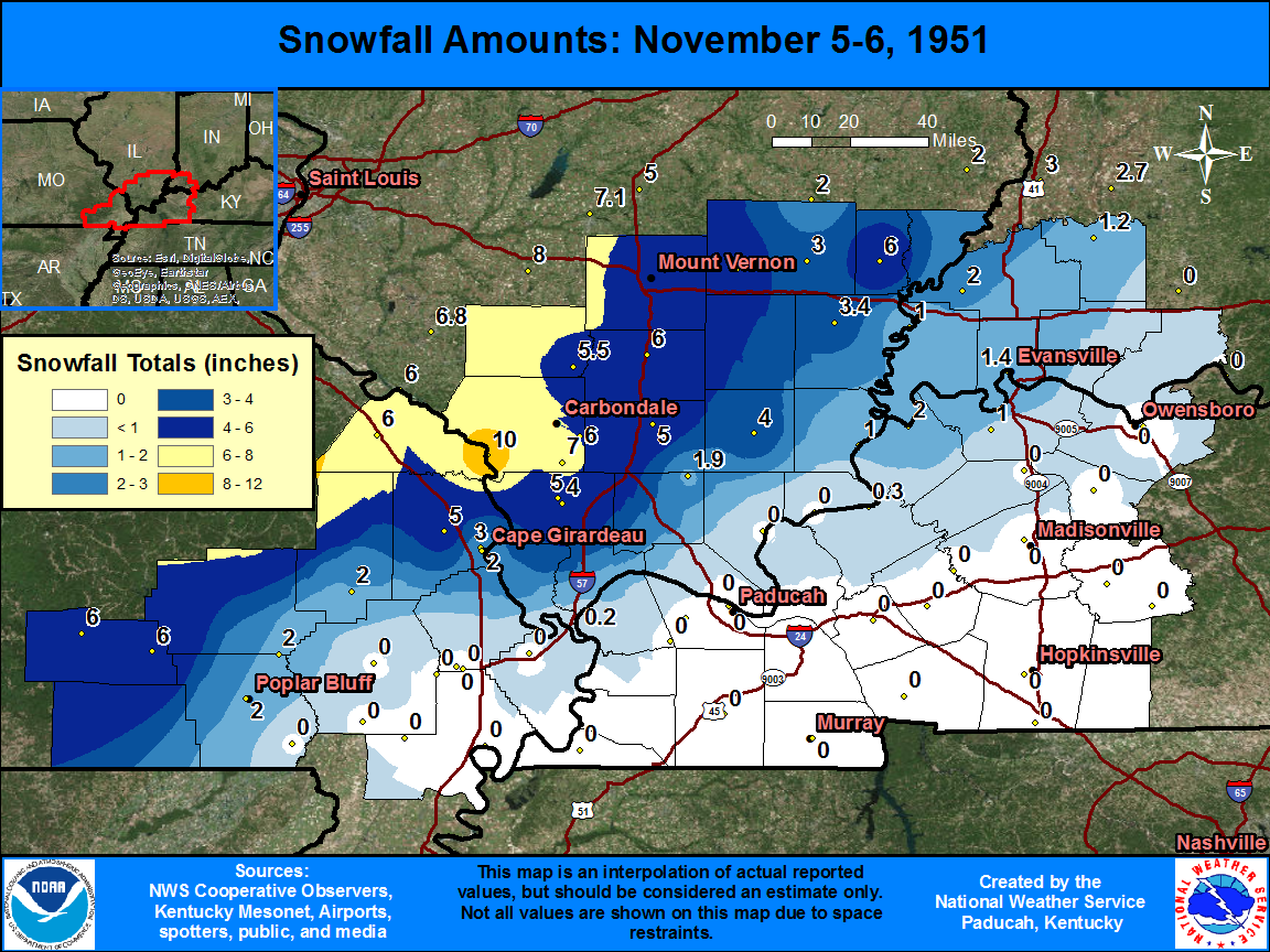
| State | Location | Type | County | Snow |
| IL | GRAND TWR 2 N | COOP | Jackson | 10 |
| IL | MAKANDA 1 NW | COOP | Jackson | 7 |
| MO | ELLSINORE | COOP | Carter | 6 |
| MO | VAN BUREN | COOP | Carter | 6 |
| MO | PERRYVILLE WATR PLT | COOP | Perry | 6 |
| IL | CARBONDALE SEWAGE PLT | COOP | Jackson | 6 |
| IL | BENTON | COOP | Franklin | 6 |
| IL | ALBION | COOP | Edwards | 6 |
| IL | DU QUOIN 4 SE | COOP | Perry | 5.5 |
| MO | JACKSON | COOP | Cape Girardeau | 5 |
| IL | COBDEN 2 S | COOP | Union | 5 |
| IL | MARION 4 NNE | COOP | Williamson | 5 |
| IL | WAYNE CITY 1 N | COOP | Wayne | 5 |
| IL | MT VERNON 3 NE | COOP | Jefferson | 4.8 |
| IL | ANNA | COOP | Union | 4 |
| IL | HARRISBURG | COOP | Saline | 4 |
| IL | CARMI 6 NW | COOP | White | 3.4 |
| MO | CP GIRARDEAU ST UNIV | COOP | Cape Girardeau | 3 |
| IL | FAIRFIELD RADIO WFIW | COOP | Wayne | 3 |
| MO | POPLAR BLUFF | COOP | Butler | 2 |
| MO | WAPPAPELLO DAM | COOP | Wayne | 2 |
| MO | ZALMA 4 E | COOP | Bollinger | 2 |
| MO | CAPE GIRARDEAU | COOP | Cape Girardeau | 2 |
| KY | UNIONTOWN DAM 49 | COOP | Union | 2 |
| IN | JOHNSON EXP F | COOP | Gibson | 2 |
| IL | NEW BURNSIDE | COOP | Johnson | 1.9 |
| IN | EVANSVILLE REGIONAL AP | WBAN | Vanderburgh | 1.9 |
| IN | EVANSVILLE MUSEUM | COOP | Vanderburgh | 1.4 |
| IN | PETERSBURG 61 BRG | COOP | Pike | 1.2 |
| IL | SHAWNEETOWN OLD TOWN | COOP | Gallatin | 1 |
| IN | NEW HARMONY | COOP | Posey | 1 |
| KY | HENDERSON 8 SSW | COOP | Henderson | 1 |
| IN | BOONVILLE 1 S | COOP | Warrick | 1 |
| KY | FORDS FERRY DAM 5O | COOP | Crittenden | 0.3 |
| IL | CAIRO | WBAN | Alexander | 0.2 |

