Overview
A cold front moved south into the area and stalled out across our southern counties. The result was an extended period of snow, with over 12 hours of nearly continuous snow falling in Paducah and several other locations. The heaviest amounts set up from southern portions of southeast Missouri into western Kentucky.Snow
Here is the official storm total snowfall map from our event on January 15th, 2018. This includes only new snowfall. It doesn’t take into account the snow depth, which factors in the snow previously on the ground from the previous Friday’s event. The highest totals were across southern portions of southeast Missouri into the Jackson Purchase and southern Pennyrile regions of western Kentucky. Amounts ranged from 5 to 8 inches in much of this area. The highest reported snowfall we have received is around 8.5 inches in East Prairie, MO which is in Mississippi County. We officially picked up 8.1" here at the office in Paducah, KY. Most of the rest of the region picked up between 1 and 4 inches of new snow.
.png) |
Photos:
 |
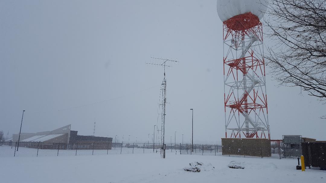 |
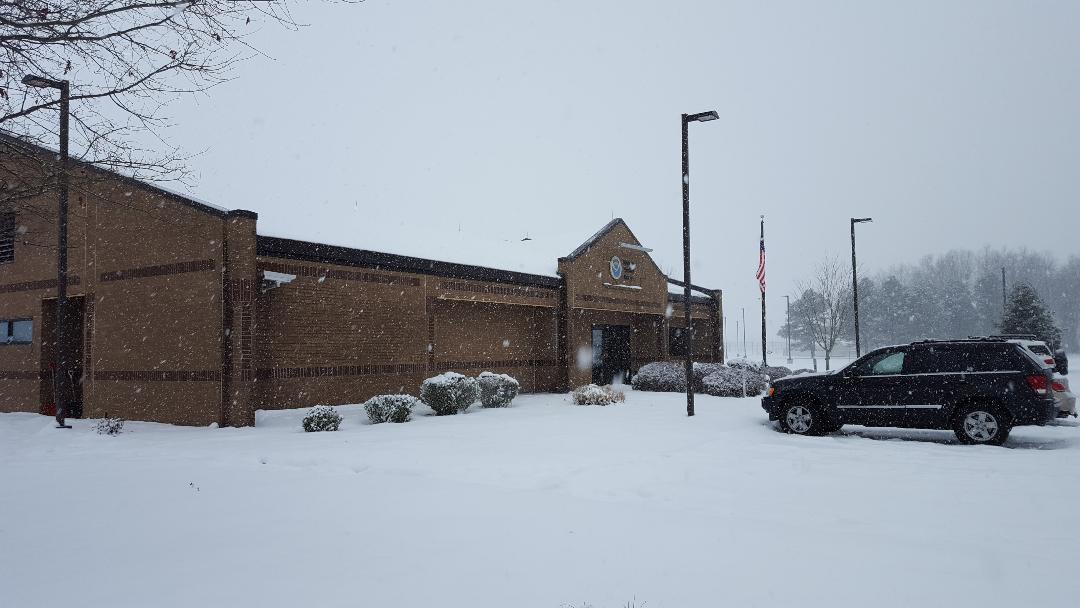
| NWS Office covered in fresh blank of snow | NWS Office Radar Tower |
Radar:
| Radar Loop from 4 AM January 15th to 6 AM January 16th |
Storm Reports
PRELIMINARY LOCAL STORM REPORT...SUMMARY NATIONAL WEATHER SERVICE PADUCAH KY 353 PM CST TUE JAN 16 2018 ..TIME... ...EVENT... ...CITY LOCATION... ...LAT.LON... ..DATE... ....MAG.... ..COUNTY LOCATION..ST.. ...SOURCE.... ..REMARKS.. 0745 AM SNOW BELLE RIVE 38.23N 88.74W 01/15/2018 E1.2 INCH JEFFERSON IL PUBLIC SNOWFALL TOTAL OF 1.25 INCHES FOR EVENT SO FAR. 0830 AM SNOW MCLEANSBORO 38.09N 88.53W 01/15/2018 E1.0 INCH HAMILTON IL PUBLIC SNOW TOTAL SO FAR FROM THIS EVENT. 0845 AM SNOW 4 ENE MOUNT VERNON 38.34N 88.84W 01/15/2018 M1.8 INCH JEFFERSON IL TRAINED SPOTTER SNOWFALL TOTAL SO FAR 1.5 MILES NORTHEAST OF MT VERNON AIRPORT. 0851 AM SNOW 3 W EVANSVILLE 37.98N 87.60W 01/15/2018 E1.0 INCH VANDERBURGH IN PUBLIC SNOW TOTAL SO FAR ON SOUTHWEST SIDE OF EVANSVILLE. 0900 AM SNOW 1 W MOUNT VERNON 38.32N 88.93W 01/15/2018 E2.0 INCH JEFFERSON IL PUBLIC SNOWFALL TOTAL SO FAR ON WEST SIDE OF MOUNT VERNON 0915 AM SNOW FORT BRANCH 38.25N 87.57W 01/15/2018 E2.5 INCH GIBSON IN PUBLIC SNOWFALL TOTAL SO FAR. 0935 AM SNOW MOUNT VERNON 37.94N 87.90W 01/15/2018 M2.0 INCH POSEY IN EMERGENCY MNGR SNOWFALL TOTAL FROM THIS EVENT SO FAR. 0940 AM SNOW MARION 37.73N 88.94W 01/15/2018 E1.0 INCH WILLIAMSON IL PUBLIC SNOWFALL TOTAL SO FAR. LIGHT SNOWING AT TIME OF REPORT. 1010 AM SNOW 5 E WARE 37.45N 89.30W 01/15/2018 M0.6 INCH UNION IL PUBLIC SNOWFALL TOTAL FROM EVENT SO FAR. 1010 AM SNOW EVANSVILLE 37.98N 87.54W 01/15/2018 E1.5 INCH VANDERBURGH IN PUBLIC SNOWFALL TOTAL SO FAR FROM DOWNTOWN AREA.. 1030 AM SNOW GALATIA 37.84N 88.61W 01/15/2018 E3.0 INCH SALINE IL PUBLIC SNOWFALL TOTAL SO FAR. 1030 AM SNOW JACKSON 37.38N 89.65W 01/15/2018 M0.8 INCH CAPE GIRARDEAU MO PUBLIC SNOWFALL TOTAL SO FAR. STILL SNOWING AT TIME OF REPORT. 1030 AM SNOW ROUND KNOB 37.22N 88.73W 01/15/2018 M3.0 INCH MASSAC IL TRAINED SPOTTER SNOWFALL TOTAL SO FAR. MODERATE SNOWING STILL. 1035 AM SNOW LA CENTER 37.07N 88.97W 01/15/2018 M1.0 INCH BALLARD KY TRAINED SPOTTER SNOWFALL TOTAL SO FAR. 1115 AM SNOW ROSICLARE 37.42N 88.35W 01/15/2018 E2.5 INCH HARDIN IL PUBLIC FACEBOOK REPORT OF 2 TO 3 INCHES SNOWFALL SO FAR. 1130 AM SNOW ZEIGLER 37.90N 89.05W 01/15/2018 E2.5 INCH FRANKLIN IL PUBLIC REPORTED VIA FACEBOOK. EVENT TOTAL SO FAR. 1135 AM SNOW 2 SE DARMSTADT 38.07N 87.55W 01/15/2018 M2.9 INCH VANDERBURGH IN BROADCAST MEDIA MEASURED 2.9 INCHES 3 MILES NORTHWEST OF EVANSVILLE AIRPORT. SNOW DEPTH IS 7 INCHES. 1135 AM SNOW MARION 37.73N 88.94W 01/15/2018 M1.8 INCH WILLIAMSON IL BROADCAST MEDIA MEASURED 1.75 INCHES IN MARION. LIGHT SNOW STILL FALLING. 1200 PM SNOW 5 NNE EVANSVILLE 38.05N 87.51W 01/15/2018 M2.0 INCH VANDERBURGH IN CO-OP OBSERVER 6 HOURLY SNOWFALL OF 2 INCHES MEASURED AT EVANSVILLE AIRPORT. 1200 PM SNOW 2 W WEST PADUCAH 37.08N 88.78W 01/15/2018 M1.1 INCH MCCRACKEN KY OFFICIAL NWS OBS 6 HOURLY SNOWFALL AMOUNT MEASURED AT NWS OFFICE.EVENT TOTAL SO FAR. SNOW DEPTH OF 3 INCHES. SNOWING AT OBSERVATION TIME. 1210 PM SNOW HENDERSON 37.84N 87.58W 01/15/2018 M1.8 INCH HENDERSON KY BROADCAST MEDIA SNOWFALL TOTAL SO FAR. 1220 PM SNOW ROUND KNOB 37.22N 88.73W 01/15/2018 M3.7 INCH MASSAC IL TRAINED SPOTTER 3.75 INCHES SNOWFALL TOTAL SO FAR. STILL SNOWING. 1220 PM SNOW SIKESTON 36.88N 89.58W 01/15/2018 E1.0 INCH SCOTT MO PUBLIC SNOWFALL TOTAL SO FAR. 1230 PM SNOW CUNNINGHAM 36.92N 88.91W 01/15/2018 E1.5 INCH CARLISLE KY PUBLIC SNOWFALL TOTAL SO FAR REPORTED VIA TWITTER. 1230 PM SNOW MOUNT CARMEL 38.42N 87.77W 01/15/2018 E4.0 INCH WABASH IL PUBLIC SNOWFALL TOTAL FOR EVENT SO FAR REPORTED VIA FACEBOOK. 1230 PM SNOW DU QUOIN 38.00N 89.24W 01/15/2018 E2.0 INCH PERRY IL PUBLIC SNOWFALL TOTAL SO FAR REPORTED VIA FACEBOOK 1245 PM SNOW 1 SW POPLAR BLUFF 36.75N 90.42W 01/15/2018 E1.5 INCH BUTLER MO PUBLIC SNOWFALL TOTAL SO FAR REPORTED VIA FACEBOOK. 0130 PM SNOW DU QUOIN 38.00N 89.24W 01/15/2018 M2.0 INCH PERRY IL EMERGENCY MNGR 0145 PM SNOW 2 N ROCKCASTLE 36.93N 87.99W 01/15/2018 E1.0 INCH LYON KY PUBLIC SNOWFALL TOTAL SO FAR REPORTED VIA FACEBOOK. 0150 PM SNOW SHAWNEETOWN 37.71N 88.17W 01/15/2018 E2.0 INCH GALLATIN IL PUBLIC SNOWFALL TOTAL SO FAR REPORTED VIA FACEBOOK. 0150 PM SNOW DUDLEY 36.79N 90.09W 01/15/2018 M2.2 INCH STODDARD MO TRAINED SPOTTER SNOWFALL TOTAL SO FAR. STILL SNOWING. 0200 PM SNOW BLUFORD 38.33N 88.74W 01/15/2018 E3.0 INCH JEFFERSON IL PUBLIC SNOWFALL TOTAL SO FAR REPORTED VIA FACEBOOK. 0200 PM SNOW SIKESTON 36.88N 89.58W 01/15/2018 E2.5 INCH SCOTT MO PUBLIC SNOWFALL TOTAL SO FAR REPORTED VIA FACEBOOK. 0205 PM SNOW DEXTER 36.79N 89.96W 01/15/2018 E2.6 INCH STODDARD MO PUBLIC SNOWFALL TOTAL SO FAR REPORTED VIA TWITTER. 0215 PM SNOW MURRAY 36.61N 88.32W 01/15/2018 M0.5 INCH CALLOWAY KY CO-OP OBSERVER NEW SNOWFALL. NOT STICKING TO ROADS SO FAR. 0215 PM SNOW HARVEY 36.81N 88.42W 01/15/2018 M1.5 INCH MARSHALL KY FIRE DEPT/RESCUE NEW SNOWFALL REPORTED SO FAR AT INTERSECTION OF HWY 58 AND WADESBORO ROAD. 0310 PM SNOW 2 W EVANSVILLE 37.98N 87.58W 01/15/2018 E2.5 INCH VANDERBURGH IN PUBLIC SNOWFALL TOTAL SO FAR VIA TWITTER. 0330 PM SNOW HARDMONEY 36.94N 88.58W 01/15/2018 E1.5 INCH GRAVES KY PUBLIC SNOWFALL TOTAL SO FAR RELAYED VIA TWITTER. 0330 PM SNOW EVANSVILLE 37.98N 87.54W 01/15/2018 M1.9 INCH VANDERBURGH IN BROADCAST MEDIA SNOWFALL REPORTED SO FAR AT TV STATION DOWNTOWN. 0330 PM SNOW 1 W GRAND CHAIN 37.25N 89.04W 01/15/2018 E2.5 INCH PULASKI IL PUBLIC SNOWFALL TOTAL SO FAR RELAYED VIA FACEBOOK. 0345 PM SNOW POPLAR BLUFF 36.76N 90.41W 01/15/2018 M2.5 INCH BUTLER MO EMERGENCY MNGR SNOWFALL TOTAL SO FAR. 0345 PM SNOW OAKLAND CITY 38.34N 87.35W 01/15/2018 M3.3 INCH GIBSON IN TRAINED SPOTTER SNOWFALL TOTAL SO FAR. 0400 PM SNOW 2 W WEST PADUCAH 37.08N 88.78W 01/15/2018 M2.8 INCH MCCRACKEN KY OFFICIAL NWS OBS SNOWFALL TOTAL AT NWS OFFICE SO FAR. STILL SNOWING CURRENTLY. 1.7 INCHES SINCE NOON. 0400 PM SNOW PADUCAH 37.07N 88.64W 01/15/2018 M2.0 INCH MCCRACKEN KY NWS EMPLOYEE 2 INCHES OF NEW SNOWFALL REPORTED. 0417 PM SNOW MURRAY 36.61N 88.32W 01/15/2018 M1.5 INCH CALLOWAY KY TRAINED SPOTTER ONE AND HALF INCH OF NEW SNOWFALL. NEW SNOW DEPTH IS NOW 7 INCHES. 0432 PM SNOW HOPKINSVILLE 36.85N 87.49W 01/15/2018 M1.3 INCH CHRISTIAN KY TRAINED SPOTTER OVER ONE INCH OF NEW SNOWFALL IN HOPKINSVILLE. SNOW DEPTH ESTIMATED 3 INCHES. 0435 PM SNOW EVANSVILLE 37.98N 87.54W 01/15/2018 M2.8 INCH VANDERBURGH IN TRAINED SPOTTER 2.8 INCHES OF NEW SNOWFALL MEASURED ON SOUTHEAST SIDE OF EVANSVILLE. 0445 PM SNOW DEXTER 36.79N 89.96W 01/15/2018 M4.0 INCH STODDARD MO EMERGENCY MNGR SNOWFALL TOTAL SO FAR. 0445 PM SNOW HENDERSON 37.84N 87.58W 01/15/2018 M3.0 INCH HENDERSON KY AMATEUR RADIO MEASURED ON SOUTH SIDE OF TOWN. NEW SNOWFALL SO FAR. 0514 PM SNOW EDDYVILLE 37.08N 88.08W 01/15/2018 M2.6 INCH LYON KY TRAINED SPOTTER NEW SNOWFALL ACCUMULATION. 0538 PM SNOW BERNIE 36.67N 89.97W 01/15/2018 M5.0 INCH STODDARD MO TRAINED SPOTTER FIVE INCH SNOW DEPTH REPORTED. 0538 PM SNOW DIEHLSTADT 36.96N 89.43W 01/15/2018 M3.0 INCH SCOTT MO TRAINED SPOTTER NEW SNOWFALL REPORTED. 0542 PM SNOW EAST PRAIRIE 36.78N 89.38W 01/15/2018 M7.0 INCH MISSISSIPPI MO TRAINED SPOTTER MEASURED SNOW DEPTH. THIS AMOUNT INCLUDES SNOW FROM PREVIOUS EVENT. 0600 PM SNOW EVANSVILLE 37.98N 87.54W 01/15/2018 M2.8 INCH VANDERBURGH IN TRAINED SPOTTER AT THE REGIONAL AIRPORT. MEASURED 2.8 INCHES SNOWFALL SINCE MIDNIGHT. 6 PM CENTRAL SNOW DEPTH 4 INCHES. 0600 PM SNOW WEST PADUCAH 37.08N 88.74W 01/15/2018 M4.6 INCH MCCRACKEN KY NWS EMPLOYEE MEASURED 4.6 INCHES OF NEW SNOWFALL SINCE MIDNIGHT. NEW SNOW DEPTH IS 7 INCHES. 0610 PM SNOW 8 W FAIRDEALING 36.66N 90.76W 01/15/2018 M3.5 INCH RIPLEY MO TRAINED SPOTTER 0643 PM SNOW 2 N HOPKINSVILLE 36.88N 87.49W 01/15/2018 M2.5 INCH CHRISTIAN KY TRAINED SPOTTER 2.5 INCHES MEASURED NEW SNOW. NEW SNOW DEPTH IS 5.5 INCHES. 0645 PM SNOW ROCKPORT 37.88N 87.05W 01/15/2018 M4.0 INCH SPENCER IN TRAINED SPOTTER MEASURED NEW SNOWFALL. SNOW DEPTH IS 7 INCHES. 0700 PM SNOW CALVERT CITY 37.03N 88.35W 01/15/2018 M3.5 INCH MARSHALL KY NWS EMPLOYEE MEASURED NEW SNOWFALL SINCE MIDNIGHT. 0707 PM SNOW EAST PRAIRIE 36.78N 89.38W 01/15/2018 M7.0 INCH MISSISSIPPI MO PUBLIC MEASURED TOTAL SNOW DEPTH. THIS INCLUDES SNOW FROM PREVOUS EVENT. 0707 PM SNOW DEXTER 36.79N 89.96W 01/15/2018 M6.3 INCH STODDARD MO PUBLIC MEASURED SNOW DEPTH 0727 PM SNOW PALMA 36.96N 88.38W 01/15/2018 M6.0 INCH MARSHALL KY PUBLIC MEASURED 6 INCH SNOW DEPTH. 0727 PM SNOW OWENSBORO 37.76N 87.12W 01/15/2018 M5.0 INCH DAVIESS KY PUBLIC MEASURED 5 INCH SNOW DEPTH. 0731 PM SNOW LONE OAK 37.04N 88.67W 01/15/2018 M5.0 INCH MCCRACKEN KY BROADCAST MEDIA MEASURED 5 INCH SNOW DEPTH. 0742 PM SNOW DUDLEY 36.79N 90.09W 01/15/2018 M5.0 INCH STODDARD MO TRAINED SPOTTER MEASURED 5 INCH SNOW DEPTH. 0744 PM SNOW METROPOLIS 37.15N 88.71W 01/15/2018 M4.5 INCH MASSAC IL NWS EMPLOYEE MEASURED NEW SNOWFALL SINCE MIDNIGHT. 0744 PM SNOW FREEMONT 36.97N 88.61W 01/15/2018 M8.0 INCH MCCRACKEN KY PUBLIC MEASURED 8 INCH SNOW DEPTH. 0815 PM SNOW OWENSBORO 37.76N 87.12W 01/15/2018 E4.0 INCH DAVIESS KY PUBLIC 24 HOUR SNOWFALL TOTAL. 0827 PM SNOW LONE OAK 37.04N 88.67W 01/15/2018 E4.5 INCH MCCRACKEN KY NWS EMPLOYEE ESTIMATED 4.5 INCH NEW SNOWFALL SINCE MIDNIGHT. MEASURED 8 INCH SNOW DEPTH. 0830 PM SNOW 4 NW EAST PRAIRIE 36.82N 89.44W 01/15/2018 M7.5 INCH MISSISSIPPI MO PUBLIC MEASURED NEW SNOWFALL SINCE MIDNIGHT. 0846 PM SNOW EAST PRAIRIE 36.78N 89.38W 01/15/2018 M11.0 INCH MISSISSIPPI MO TRAINED SPOTTER MEASURED TOTAL SNOW DEPTH. THIS INCLUDES SNOW FROM PREVIOUS EVENT. 0850 PM SNOW 2 N HOPKINSVILLE 36.88N 87.49W 01/15/2018 M3.5 INCH CHRISTIAN KY TRAINED SPOTTER MEASURED NEW SNOWFALL. 0900 PM SNOW WEST PADUCAH 37.08N 88.74W 01/15/2018 M6.1 INCH MCCRACKEN KY NWS EMPLOYEE MEASURED NEW SNOWFALL TODAY AT THE NWS OFFICE. SNOW STILL FALLING. 0904 PM SNOW 8 NE MURRAY 36.69N 88.21W 01/15/2018 M4.5 INCH CALLOWAY KY TRAINED SPOTTER 0919 PM SNOW ROUND KNOB 37.22N 88.73W 01/15/2018 M6.8 INCH MASSAC IL TRAINED SPOTTER MEASURED NEW SNOWFALL SO FAR TODAY, SNOW STILL FALLING. 0939 PM SNOW HOWARDVILLE 36.57N 89.60W 01/15/2018 E6.0 INCH NEW MADRID MO PUBLIC 0940 PM SNOW 13 SSE EDDYVILLE 36.90N 87.99W 01/15/2018 M4.2 INCH TRIGG KY PUBLIC 1000 PM SNOW PADUCAH 37.07N 88.64W 01/15/2018 M5.3 INCH MCCRACKEN KY NWS EMPLOYEE MEASURED DAILY NEW SNOWFALL. SNOW DEPTH 8 INCHES. 1000 PM SNOW CALVERT CITY 37.03N 88.35W 01/15/2018 M5.0 INCH MARSHALL KY NWS EMPLOYEE NEW DAILY SNOWFALL MEASUREMENT. STILL SNOWING. 1014 PM SNOW MURRAY 36.61N 88.32W 01/15/2018 M4.0 INCH CALLOWAY KY TRAINED SPOTTER MEASURED 4.0 INCHES NEW SNOWFALL FOR TODAY. NEW SNOW DEPTH NOW 9 INCHES. 1051 PM SNOW EDDYVILLE 37.08N 88.08W 01/15/2018 M5.6 INCH LYON KY TRAINED SPOTTER MEASURED NEW SNOWFALL FOR TODAY. 1100 PM SNOW BENTON 36.85N 88.36W 01/15/2018 M7.5 INCH MARSHALL KY TRAINED SPOTTER MEASURED SNOWFALL FOR TODAY. 1105 PM HEAVY SNOW EAST PRAIRIE 36.78N 89.38W 01/15/2018 M12.0 INCH MISSISSIPPI MO TRAINED SPOTTER SNOW HAS ENDED. MEASURED ONE FOOT TOTAL SNOW DEPTH. THIS INCLUDES SNOW FROM PREVIOUS EVENT. 1145 PM HEAVY SNOW WEST PADUCAH 37.08N 88.74W 01/15/2018 M8.1 INCH MCCRACKEN KY NWS EMPLOYEE NWS OFFICE IN PADUCAH. MEASURED DAILY SNOWFALL TOTAL. SNOW DEPTH ROUNDED TO 8 INCHES. 1238 AM SNOW LONE OAK 37.04N 88.67W 01/16/2018 M9.0 INCH MCCRACKEN KY TRAINED SPOTTER MEASURED SNOW DEPTH FROM PAST 24 HOUR SNOWFALL COMBINED WITH PREVIOUS SNOW ON GROUND. 1241 AM SNOW HOPKINSVILLE 36.85N 87.49W 01/16/2018 M5.0 INCH CHRISTIAN KY PUBLIC EVENT SNOW TOTAL THUS FAR. 1246 AM SNOW HICKORY 36.82N 88.65W 01/16/2018 M7.3 INCH GRAVES KY TRAINED SPOTTER MEASURED SNOWFALL FOR THE EVENT. SNOW DEPTH MEASURED 12 INCHES. 0250 AM SNOW MURRAY 36.61N 88.32W 01/16/2018 M9.0 INCH CALLOWAY KY PUBLIC EVENT SNOW TOTAL THUS FAR. 0425 AM SNOW 2 N HOPKINSVILLE 36.88N 87.49W 01/16/2018 M6.1 INCH CHRISTIAN KY TRAINED SPOTTER MEASURED SNOWFALL FOR THIS EVENT. 0605 AM SNOW MURRAY 36.61N 88.32W 01/16/2018 M5.0 INCH CALLOWAY KY CO-OP OBSERVER EVENT TOTAL 5 INCHES NEW SNOWFALL. SNOW DEPTH 11 INCHES. 0700 AM SNOW 1 S AURORA 36.76N 88.14W 01/16/2018 M7.0 INCH MARSHALL KY CO-OP OBSERVER MEASURED NEW SNOWFALL PAST 24 HOURS AT KENLAKE RESORT COOP. SNOW DEPTH IS 9 INCHES. 0700 AM SNOW 1 WNW GUTHRIE 36.66N 87.19W 01/16/2018 M8.5 INCH TODD KY COCORAHS MEASURED NEW SNOWFALL PAST 24 HOURS. SNOW DEPTH IS 11 INCHES. 0700 AM SNOW 13 N ELKTON 37.00N 87.16W 01/16/2018 M4.6 INCH TODD KY COCORAHS MEASURED NEW SNOWFALL FROM YESTERDAY. SNOW DEPTH WAS 6 INCHES. 0700 AM SNOW NORTONVILLE 37.19N 87.46W 01/16/2018 M3.1 INCH HOPKINS KY COCORAHS MEASURED NEW SNOWFALL FROM YESTERDAY. SNOW DEPTH IS 7 INCHES. 0700 AM SNOW FRANCISCO 38.33N 87.45W 01/16/2018 M3.0 INCH GIBSON IN COCORAHS MEASURED NEW SNOWFALL FROM YESTERDAY. SNOW DEPTH IS 8 INCHES. 0700 AM SNOW 6 NW HOLLAND 38.31N 87.12W 01/16/2018 M3.0 INCH PIKE IN COCORAHS MEASURED NEW SNOWFALL FROM YESTERDAY. SNOW DEPTH IS 5 INCHES. 0700 AM SNOW 1 SW SANTA CLAUS 38.11N 86.94W 01/16/2018 M3.5 INCH SPENCER IN COCORAHS MEASURED NEW SNOWFALL FROM YESTERDAY. 0700 AM SNOW 1 ENE PETERSBURG 38.50N 87.26W 01/16/2018 M3.0 INCH PIKE IN COCORAHS MEASURED NEW SNOWFALL FROM YESTERDAY. SNOW DEPTH IS 5 INCHES. 0700 AM SNOW 1 NE PERRYVILLE 37.74N 89.86W 01/16/2018 M1.0 INCH PERRY MO COCORAHS MEASURED NEW SNOWFALL FROM YESTERDAY. 0700 AM SNOW SALEM 37.27N 88.24W 01/16/2018 M4.2 INCH LIVINGSTON KY COCORAHS MEASURED NEW SNOWFALL FROM YESTERDAY. 0700 AM SNOW 3 NW OWENSBORO 37.79N 87.16W 01/16/2018 M3.8 INCH DAVIESS KY COCORAHS MEASURED NEW SNOWFALL FROM YESTERDAY. 0800 AM SNOW POPLAR BLUFF 36.76N 90.41W 01/16/2018 M5.0 INCH BUTLER MO EMERGENCY MNGR MEASURED 5 INCHES OF NEW SNOWFALL PAST 24 HOURS. 0800 AM SNOW CLIFTY 37.00N 87.15W 01/16/2018 M4.6 INCH TODD KY PUBLIC MEASURED 4.6 INCHES OF NEW SNOWFALL FOR PAST 24 HOURS. 0800 AM SNOW LOVELACEVILLE 36.97N 88.83W 01/16/2018 M6.0 INCH BALLARD KY PUBLIC MEASURED 6 INCHES OF NEW SNOWFALL PAST 24 HOURS. 0800 AM SNOW HICKMAN 36.56N 89.19W 01/16/2018 M8.0 INCH FULTON KY PUBLIC MEASURED 8 INCHES OF NEW SNOWFALL PAST 24 HOURS. 0900 AM SNOW 2 N ROCKCASTLE 36.93N 87.99W 01/16/2018 E5.0 INCH LYON KY PUBLIC MEASURED NEW SNOWFALL PAST 24 HOURS. RELAYED VIA FACEBOOK. 0930 AM SNOW HOPKINSVILLE 36.85N 87.49W 01/16/2018 E6.2 INCH CHRISTIAN KY PUBLIC 6.25 INCHES OF NEW SNOWFALL FROM YESTERDAYS EVENT. RELAYED VIA TWITTER. 1000 AM SNOW MAYFIELD 36.74N 88.65W 01/16/2018 E7.0 INCH GRAVES KY PUBLIC MEASURED NEW SNOWFALL PAST 24 HOURS. RELAYED VIA TWITTER. 1100 AM SNOW NEW CONCORD 36.60N 88.07W 01/16/2018 E6.0 INCH CALLOWAY KY PUBLIC MEASURED NEW SNOWFALL PAST 24 HOURS. SNOW DEPTH IS 11 INCHES. RELAYED VIA FACEBOOK 1100 AM SNOW 2 N HOPKINSVILLE 36.88N 87.49W 01/16/2018 M7.3 INCH CHRISTIAN KY TRAINED SPOTTER MEASURED NEW SNOWFALL PAST 24 HOURS. 1100 AM SNOW 2 ESE ROSEWOOD 37.09N 86.99W 01/16/2018 E5.5 INCH MUHLENBERG KY PUBLIC MEASURED NEW SNOWFALL PAST 24 HOURS. RELAYED VIA FACEBOOK 1200 PM SNOW MARION 37.33N 88.08W 01/16/2018 M2.2 INCH CRITTENDEN KY EMERGENCY MNGR EMA MEASURED 2.25 INCHES OF SNOW FROM YESTERDAY. 1200 PM SNOW CALHOUN 37.54N 87.26W 01/16/2018 E3.0 INCH MCLEAN KY EMERGENCY MNGR ESTIMATED NEW SNOWFALL FROM YESTERDAY. 1200 PM SNOW PRINCETON 37.11N 87.88W 01/16/2018 E4.0 INCH CALDWELL KY EMERGENCY MNGR ESTIMATED NEW SNOWFALL YESTERDAY. 1200 PM SNOW MORTONS GAP 37.24N 87.47W 01/16/2018 M5.0 INCH HOPKINS KY TRAINED SPOTTER MEASURED NEW SNOWFALL FROM YESTERDAY. 1200 PM SNOW 2 S CANTON 36.77N 87.96W 01/16/2018 E7.0 INCH TRIGG KY EMERGENCY MNGR ESTIMATED 7 INCHES OF NEW SNOWFALL YESTERDAY. 1200 PM SNOW VIENNA 37.41N 88.89W 01/16/2018 E4.0 INCH JOHNSON IL EMERGENCY MNGR ESTIMATED NEW SNOWFALL FROM YESTERDAY. 1200 PM SNOW TUNNEL HILL 37.52N 88.84W 01/16/2018 E3.0 INCH JOHNSON IL EMERGENCY MNGR ESTIMATED NEW SNOWFALL FROM YESTERDAY. 1200 PM SNOW BELKNAP 37.32N 88.94W 01/16/2018 E5.0 INCH JOHNSON IL EMERGENCY MNGR ESTIMATED NEW SNOWFALL FROM YESTERDAY. 1200 PM SNOW EAST PRAIRIE 36.78N 89.38W 01/16/2018 M8.5 INCH MISSISSIPPI MO EMERGENCY MNGR MEASURED NEW SNOWFALL FROM YESTERDAY. 1200 PM SNOW POPLAR BLUFF 36.76N 90.41W 01/16/2018 M5.0 INCH BUTLER MO EMERGENCY MNGR EMA MEASURED 5 INCHES OF SNOW FROM YESTERDAY. 1200 PM SNOW BARDWELL 36.87N 89.01W 01/16/2018 M6.0 INCH CARLISLE KY EMERGENCY MNGR EMA MEASURED 6 INCHES OF SNOW FROM YESTERDAY. 1200 PM SNOW MCLEANSBORO 38.09N 88.53W 01/16/2018 M2.2 INCH HAMILTON IL EMERGENCY MNGR EMA MEASURED 2.2 INCHES OF SNOW FROM YESTERDAY. 1200 PM SNOW CARMI 38.09N 88.17W 01/16/2018 M2.2 INCH WHITE IL EMERGENCY MNGR EMA MEASURED 2.2 INCHES OF SNOW FROM YESTERDAY. 1200 PM SNOW DEXTER 36.79N 89.96W 01/16/2018 E6.0 INCH STODDARD MO EMERGENCY MNGR ESTIMATED NEW SNOWFALL FROM YESTERDAY. 1200 PM SNOW CHARLESTON 36.92N 89.34W 01/16/2018 E6.8 INCH MISSISSIPPI MO EMERGENCY MNGR ESTIMATED NEW SNOWFALL FROM YESTERDAY. 1200 PM SNOW MADISONVILLE 37.34N 87.51W 01/16/2018 E4.5 INCH HOPKINS KY EMERGENCY MNGR ESTIMATED NEW SNOWFALL OF 4.5 INCHES IN MADISONVILLE YESTERDAY. 1200 PM SNOW GREENVILLE 37.21N 87.18W 01/16/2018 M4.0 INCH MUHLENBERG KY EMERGENCY MNGR MEASURED NEW SNOWFALL FROM YESTERDAY.
 |
Media use of NWS Web News Stories is encouraged! Please acknowledge the NWS as the source of any news information accessed from this site. |
|

