Overview
Two organized severe weather outbreaks occurred on April 5. The first outbreak, which consisted of a series of supercell thunderstorms, included the deadly Bollinger County tornado in southeast Missouri. This outbreak was during the pre-dawn hours, from about 2 AM to 6 AM. The second outbreak consisted of a broken squall line of thunderstorms that moved east across the region from mid- morning through mid-afternoon. Pockets of damaging wind accompanied these storms, along with a few brief tornadoes.Tornadoes:
The National Weather Service confirmed five tornadoes occurred during this event. Additionally, straight-line winds estimated as high as 95 mph occurred in Calvert City, KY.
|
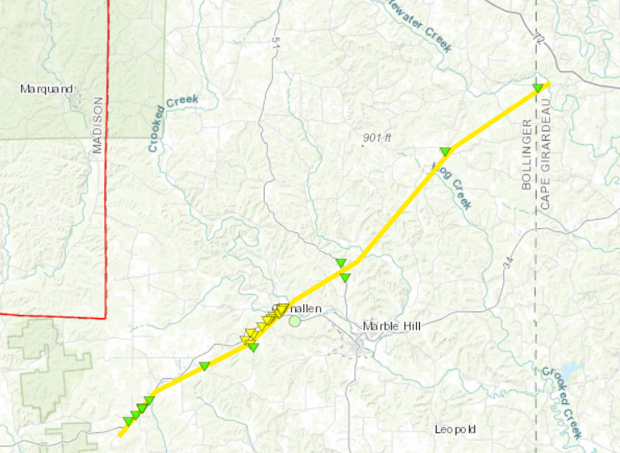
Tornado #1 - Near Marble Hill, MO
|
||||||||||||||||
|
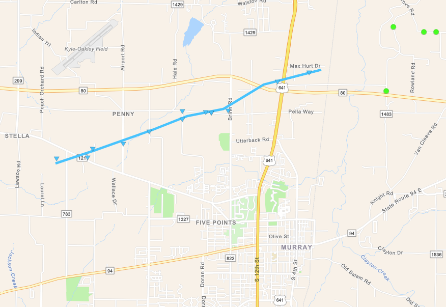
Tornado #2 - Northwest of Murray, KY
|
||||||||||||||||
|
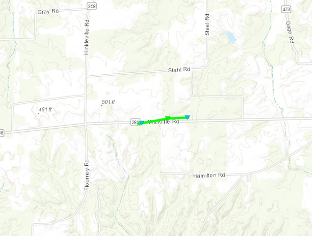
Tornado #3 - Near Gage, KY
|
||||||||||||||||
|
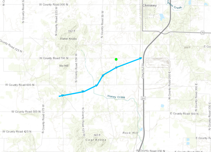
Tornado #4 - Near Chrisney, IN
|
||||||||||||||||
|
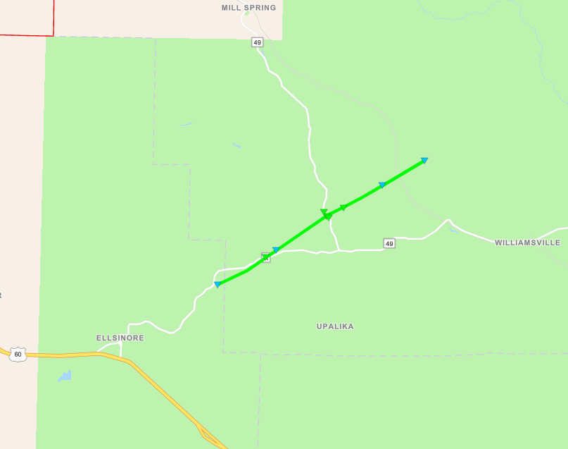
Tornado #5 - Near Williamsville, MO
|
||||||||||||||||
The Enhanced Fujita (EF) Scale classifies tornadoes into the following categories:
| EF0 Weak 65-85 mph |
EF1 Moderate 86-110 mph |
EF2 Significant 111-135 mph |
EF3 Severe 136-165 mph |
EF4 Extreme 166-200 mph |
EF5 Catastrophic 200+ mph |
 |
|||||
Photos
Damage Photos - More to be added later. Click on images for larger size.
 |
 |
 |
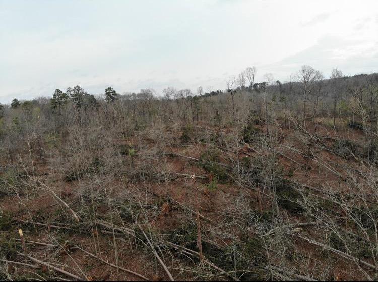 |
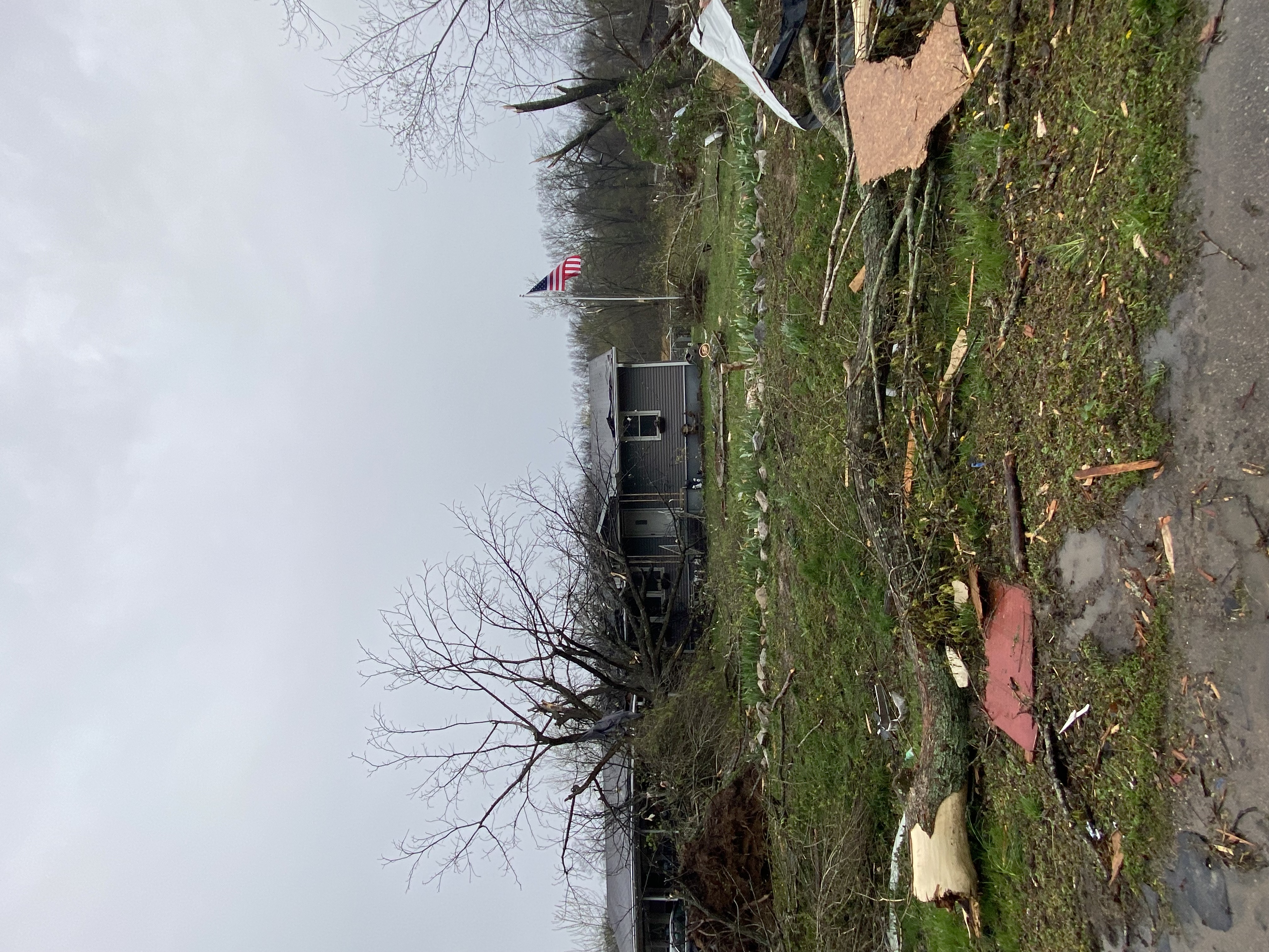
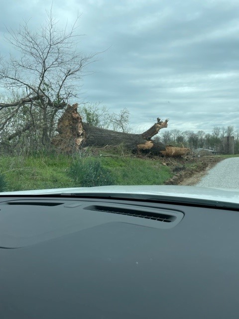
| Tornado damage in Bollinger County, Missouri. (NWS damage survey) | Tornado damage in Glenallen, Missouri. (NWS damage survey) | Uprooted tree in Spencer County, Indiana. (Spencer County EMA) | Tree damage south of Mill Spring in Wayne County, Missouri. (Wayne County EMA) |
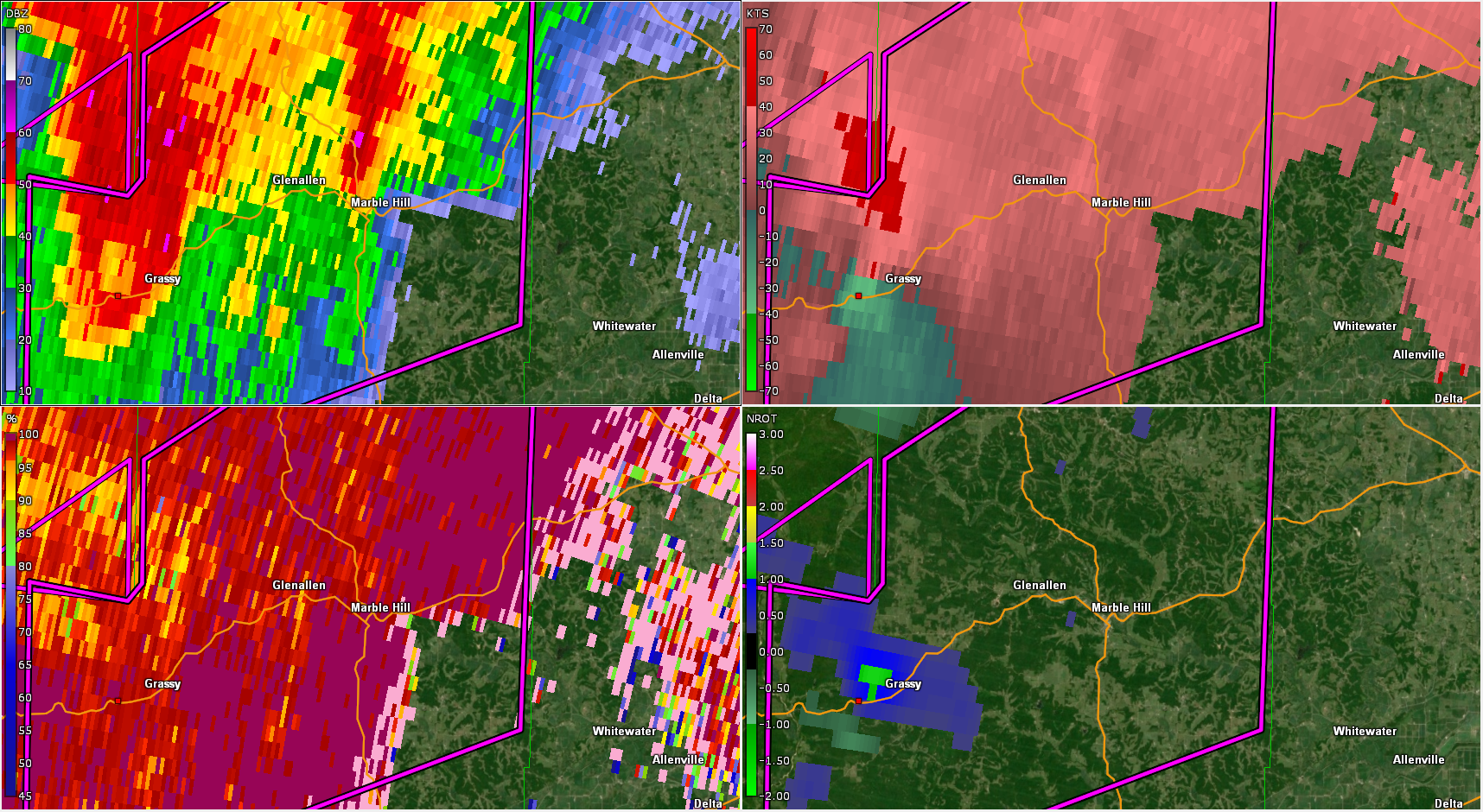
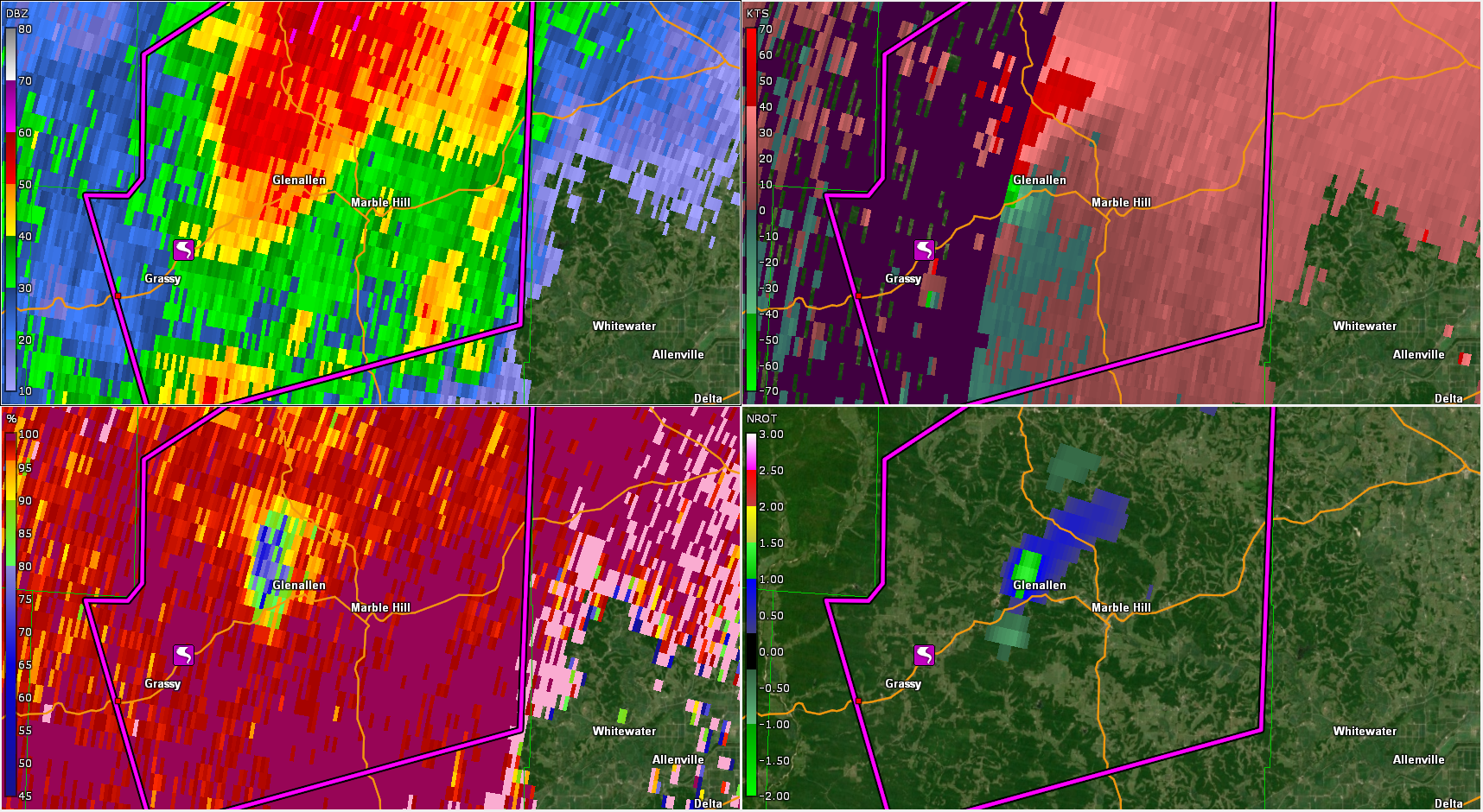
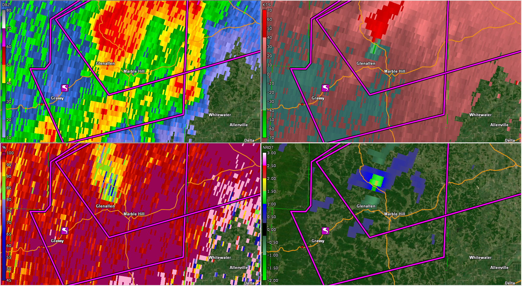
Radar
Four-panel images as the storm moved through Bollinger Co., MO. Each panel of the images below shows a different radar product. Upper left: Base reflectivity. Upper right: Storm-relative velocity. Lower left: Correlation coefficient. Lower right: Normalized rotation. The purple lines are the outlines of the tornado warning polygons issued by the NWS. Click on images for larger size.
 |
 |
 |
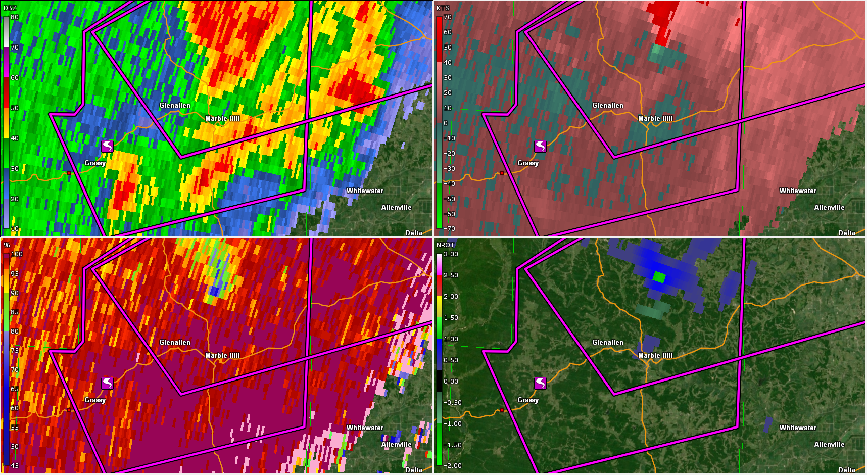 |
| 3:32 AM CDT | 3:41 AM CDT | 3:44 AM CDT | 3:48 AM CDT |
Storm Reports
PRELIMINARY LOCAL STORM REPORT...SUMMARY
NATIONAL WEATHER SERVICE PADUCAH KY
559 PM CDT THU APR 6 2023

..TIME...   ...EVENT...      ...CITY LOCATION...     ...LAT.LON...
..DATE...   ....MAG....      ..COUNTY LOCATION..ST.. ...SOURCE....
            ..REMARKS..

0249 AM     TORNADO          4 ENE ELLSINORE         36.96N 90.69W
04/05/2023                   WAYNE              MO   NWS STORM SURVEY

            AN EF-1 TORNADO STRUCK PORTIONS OF FAR
            SOUTHWEST WAYNE COUNTY IN THE EARLY MORNING
            HOURS OF APRIL 5. SEVERAL HUNDRED TREES WERE
            SNAPPED OR UPROOTED ALONG HIGHWAY A AND
            HIGHWAY 49. ONE GARAGE SUFFERED MINOR ROOF
            DAMAGED BY A FALLING TREE. THE TORNADO
            CAUSED SHINGLE DAMAGE TO A HOUSE LOCATED
            ALONG HIGHWAY A.
0330 AM     TORNADO          2 SW GRASSY             37.25N 90.14W
04/05/2023                   BOLLINGER          MO   NWS STORM SURVEY

            *** 5 FATAL, 4 INJ ***
            A NWS STORM SURVEY FOUND AN EF-2 TORNADO
            WITH ESTIMATED PEAK WINDS OF 130 MPH STRUCK
            BOLLINGER COUNTY, MISSOURI, EARLY WEDNESDAY
            MORNING APRIL 5TH. SEVERAL MANUFACTURED
            HOMES WERE TOTALLY DESTROYED. ADDITIONALLY,
            NUMEROUS HOMES SUFFERED MAJOR STRUCTURAL
            DAMAGE, INCLUDING ROOF DAMAGE, BROKEN
            WINDOWS AND COLLAPSE OF WALLS. THE MOST
            SEVERE DAMAGE OCCURRED IN GLENALLEN,
            MISSOURI, WHERE MULTIPLE FATALITIES AND
            INJURIES OCCURRED. SEVERE TREE DAMAGE
            OCCURRED IN THE VICINITY OF GLENALLEN, WHERE
            HUNDREDS OF TREES WERE SNAPPED AT THE BASE.
            DOZENS OF FARM OUTBUILDINGS SUSTAINED MAJOR
            DAMAGE ALONG THE PATH OF THE TORNADO.

0341 AM     TORNADO          5 WSW GLENALLEN         37.28N 90.11W
04/05/2023                   BOLLINGER          MO   LAW ENFORCEMENT

            MULTIPLE HOMES DAMAGED. UNKNOWN IF THERE ARE
            ANY INJURIES OR FATALITIES AT THIS TIME.

0412 AM     TSTM WND GST     GRAND TOWER             37.63N 89.50W
04/05/2023  E60 MPH          JACKSON            IL   TRAINED SPOTTER

            PEA SIZED HAIL WAS ALSO REPORTED.

0443 AM     TSTM WND GST     5 NNW OXLY              36.67N 90.71W
04/05/2023  M57 MPH          RIPLEY             MO   PUBLIC


0445 AM     TSTM WND GST     3 SSW DE SOTO           37.78N 89.25W
04/05/2023  M67 MPH          JACKSON            IL   ASOS

            ASOS STATION KMDH CARBONDALE IL.

1249 PM     TSTM WND DMG     3 S MARION              37.69N 88.94W
04/05/2023                   WILLIAMSON         IL   BROADCAST MEDIA

            SEVERAL TREES DAMAGED AND A LARGE POLE BARN.
            SECTION OF ROOF TORN OFF THE POLE BARN.

0100 PM     TSTM WND DMG     HARRISBURG              37.74N 88.55W
04/05/2023                   SALINE             IL   BROADCAST MEDIA

            5 TO 6 LARGE PINE TREES TOPPED.

0113 PM     TSTM WND DMG     1 NNE COLUMBUS          36.78N 89.09W
04/05/2023                   HICKMAN            KY   EMERGENCY MNGR

            MULTIPLE HOMES HAVE ROOF DAMAGE. SEVERAL
            TREES DOWN.

0115 PM     TSTM WND DMG     1 ENE ARLINGTON         36.79N 89.00W
04/05/2023                   CARLISLE           KY   EMERGENCY MNGR

            TREE ON TRAILER. CHURCH HAS MODERATE ROOF
            DAMAGE. TREE ON CARPORT AND TRUCK. CARPORT
            LIFTED IN THE AIR STRUCK 2 HOUSES AND A
            POWER POLE.

0115 PM     TSTM WND DMG     ELDORADO                37.81N 88.44W
04/05/2023                   SALINE             IL   TRAINED SPOTTER

            TREES DAMAGED AND CARPORT BLOWN OVER.

0115 PM     TSTM WND DMG     5 NNW BROUGHTON         38.00N 88.49W
04/05/2023                   HAMILTON           IL   EMERGENCY MNGR

            SMALL SHEDS BLOWN OVER. ALUMINUM BUILDING
            BLOWN OVER.

0115 PM     TSTM WND DMG     2 SSE DALE              37.97N 88.48W
04/05/2023                   HAMILTON           IL   TRAINED SPOTTER

            POLE BARN COLLAPSED.

0118 PM     TSTM WND DMG     1 W WICKLIFFE           36.97N 89.09W
04/05/2023                   BALLARD            KY   BROADCAST MEDIA

            DAMAGE TO MULTIPLE HOMES.
0126 PM     TORNADO          2 W GAGE                36.99N 88.93W
04/05/2023                   BALLARD            KY   NWS STORM SURVEY

            A SHORT LIVED EF1 TORNADO OCCURRED ALONG
            HIGHWAY 286 IN BALLARD COUNTY DURING THE
            AFTERNOON OF APRIL 5. THE MOST SEVERE DAMAGE
            WAS TO A RESIDENCE LOCATED ALONG HIGHWAY
            286, WHICH SUFFERED SIGNIFICANT SHINGLE,
            GUTTER, AND FASCIA DAMAGE AS WELL AS DAMAGE
            TO AN AIR CONDITIONING UNIT AND AN ATTACHED
            PORCH. SEVERAL LARGE TREE LIMBS WERE ALSO
            DOWNED BY THE TORNADO IN THE VICINITY OF THE
            RESIDENCE.

0138 PM     TSTM WND DMG     3 S REIDLAND            36.96N 88.51W
04/05/2023                   MCCRACKEN          KY   EMERGENCY MNGR

            TREE DOWN WITH POWER LINES AND BROKEN POLE.
0152 PM     TSTM WND DMG     2 W CALVERT CITY        37.03N 88.38W
04/05/2023                   MARSHALL           KY   NWS STORM SURVEY

            A NWS STORM SURVEY FOUND STRAIGHT-LINE WIND
            DAMAGE OCCURRED IN CALVERT CITY ON THE
            AFTERNOON OF APRIL 5. ESTIMATED PEAK WINDS
            WERE AROUND 95 MPH. ONE BARN COLLAPSED.
            NUMEROUS HOMES HAD SHINGLE DAMAGE. MANY
            TREES WERE SNAPPED OR UPROOTED.

0157 PM     TSTM WND DMG     CALVERT CITY            37.03N 88.36W
04/05/2023                   MARSHALL           KY   TRAINED SPOTTER

            NUMEROUS TREES SNAPPED AND UPROOTED.

0159 PM     TSTM WND GST     2 ESE GILBERTSVILLE     37.02N 88.27W
04/05/2023  M59 MPH          LIVINGSTON         KY   TRAINED SPOTTER

            MEASURED ON TOP OF KENTUCKY DAM.

0202 PM     TORNADO          3 NNW MURRAY            36.65N 88.34W
04/05/2023                   CALLOWAY           KY   NWS STORM SURVEY

            EF-0 TORNADO TOUCHED DOWN 5 MILES WNW OF
            MURRAY NEAR STELLA AND LIFTED 3.3 MILES
            NORTH OF MURRAY. PATH LENGTH OF 5.3 MILES
            AND PEAK WIDTH OF 50 YARDS. MAX WINDS OF 85
            MPH. SEVERAL HOMES WITH SHINGLE DAMAGE. ONE
            GARAGE SLID OFF ITS FOUNDATION. SEVERAL
            TREES WERE SNAPPED OR UPROOTED. ROOF DAMAGE
            AND WINDOWS BLOWN IN AT A COMMERCIAL SITE.
            THE MOST SIGNIFICANT DAMAGE OCCURRED ALONG
            POOR FARM ROAD.

0207 PM     TSTM WND DMG     1 ENE MURRAY            36.62N 88.30W
04/05/2023                   CALLOWAY           KY   EMERGENCY MNGR

            POLES AND POWER LINES DOWN. DEBRIS ON FIELDS
            AND ROADSIDES.

0213 PM     TSTM WND DMG     2 N EVANSVILLE          38.01N 87.55W
04/05/2023                   VANDERBURGH        IN   BROADCAST MEDIA

            WIRES DOWN ON KANSAS ROAD & SEVERAL TREES
            DOWN ON KREMER ROAD.

0216 PM     TSTM WND DMG     2 E DARMSTADT           38.09N 87.53W
04/05/2023                   VANDERBURGH        IN   BROADCAST MEDIA

            LARGE TREE DOWN.

0217 PM     TSTM WND GST     EVANSVILLE              37.98N 87.54W
04/05/2023  M62 MPH          VANDERBURGH        IN   ASOS

            MEASURED AT THE EVANSVILLE AIRPORT ASOS.

0221 PM     TSTM WND GST     HENDERSON               37.84N 87.58W
04/05/2023  M59 MPH          HENDERSON          KY   AWOS

            MEASURED AT THE HENDERSON AIRPORT AWOS.

0240 PM     TSTM WND GST     4 NW CALHOUN            37.59N 87.32W
04/05/2023  M54 MPH          MCLEAN             KY   MESONET

            MESONET STATION PVRT CALHOUN KY 5 NW.
0242 PM     TORNADO          4 SW CHRISNEY           37.97N 87.09W
04/05/2023                   SPENCER            IN   NWS STORM SURVEY

            AN EF0 TORNADO IMPACTED PORTIONS OF RURAL
            SPENCER COUNTY DURING THE AFTERNOON HOURS OF
            APRIL 5. THE DAMAGE OCCURRED SOUTHEAST OF
            CHRISNEY. THE PRIMARY DAMAGE CAUSED BY THE
            TORNADO WAS DOWNING SEVERAL LARGE TREE LIMBS
            AS WELL AS SNAPPING OR UPROOTING A FEW
            TREES. THE TORNADO KNOCKED DOWN THE WALLS OF
            A BARN NEAR THE INTERSECTION OF COUNTY ROAD
            700 NORTH AND OLD US HIGHWAY 231.

0243 PM     TSTM WND GST     OWENSBORO               37.76N 87.12W
04/05/2023  M66 MPH          DAVIESS            KY   AWOS

            MEASURED 66 MPH GUST AT THE OWENSBORO
            AIRPORT.

0245 PM     TSTM WND DMG     4 N MOSELEYVILLE        37.72N 87.18W
04/05/2023                   DAVIESS            KY   PUBLIC

            HWY 81 POLES IN THE ROAD.

0250 PM     TSTM WND DMG     CHRISNEY                38.01N 87.03W
04/05/2023                   SPENCER            IN   EMERGENCY MNGR

            BARN DESTROYED IN SOUTHERN CHRISNEY AREA.
            TIME ESTIMATED VIA RADAR.

0253 PM     FUNNEL CLOUD     CHRISNEY                38.01N 87.03W
04/05/2023                   SPENCER            IN   TRAINED SPOTTER

            FUNNEL CLOUD SPOTTED JUST NORTH OF CHRISNEY,
            MORE THAN HALFWAY TO THE GROUND.

0254 PM     TSTM WND DMG     1 N MOSELEYVILLE        37.68N 87.19W
04/05/2023                   DAVIESS            KY   EMERGENCY MNGR

            HIGHWAY 81 CLOSED IN DAVIESS COUNTY DUE TO
            POWER LINES AND POLES ON THE HIGHWAY. TIME
            ESTIMATED VIA RADAR. LOCATION IS ESTIMATED
            FOR LSR.

0255 PM     TSTM WND GST     2 NNW LIVERMORE         37.52N 87.14W
04/05/2023  M55 MPH          MCLEAN             KY   PUBLIC


0256 PM     TSTM WND GST     4 SW OWENSBORO          37.72N 87.17W
04/05/2023  M66 MPH          DAVIESS            KY   AWOS

            AWOS STATION KOWB OWENSBORO KY.

0300 PM     TSTM WND GST     2 WSW CENTRAL CITY      37.29N 87.16W
04/05/2023  M58 MPH          MUHLENBERG         KY   MESONET

            MESONET STATION CCTY GREENVILLE KY 6 N.


&&
.
Environment
Here is the SPC outlook text for 12z Apr 4-12z Apr 5: A large upper-level trough is deepening over the Rockies today, with an 80-90 knot mid level speed max rotating across the Plains. The associated surface low will track from central KS into IA this afternoon while a warm front lifts northward across eastern IA and northern IL. This will result in a large unstable warm sector across parts of IA/IL/MO where forecast soundings show strong low-level shear profiles and ample CAPE for severe/supercell storms. This scenario is quite different than last Friday, with more concerns for capping in the warm sector and pockets of dry low-level air that reduces confidence in the number of storms and intense tornado potential. Wind fields will strengthen throughout the night and capping will weaken, leading to a serious concern for nocturnal tornadoes over the southern moderate risk area in MO/AR.
On April 5, a cold front trailing south from the surface low moved east across the lower Ohio and mid-Mississippi Valleys, preceded by a squall line of thunderstorms and a few rotating storms.
Click on images for larger size.
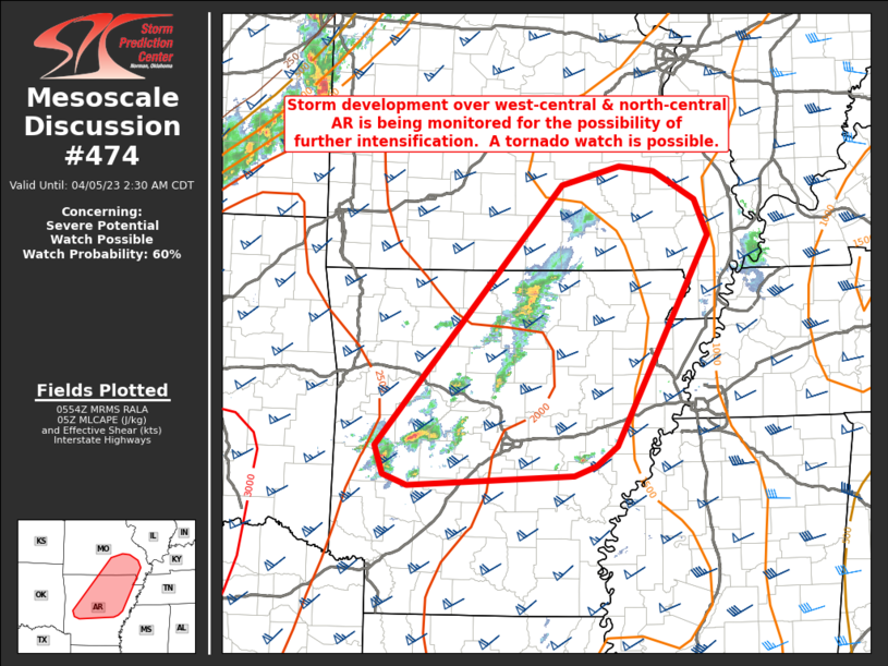 |
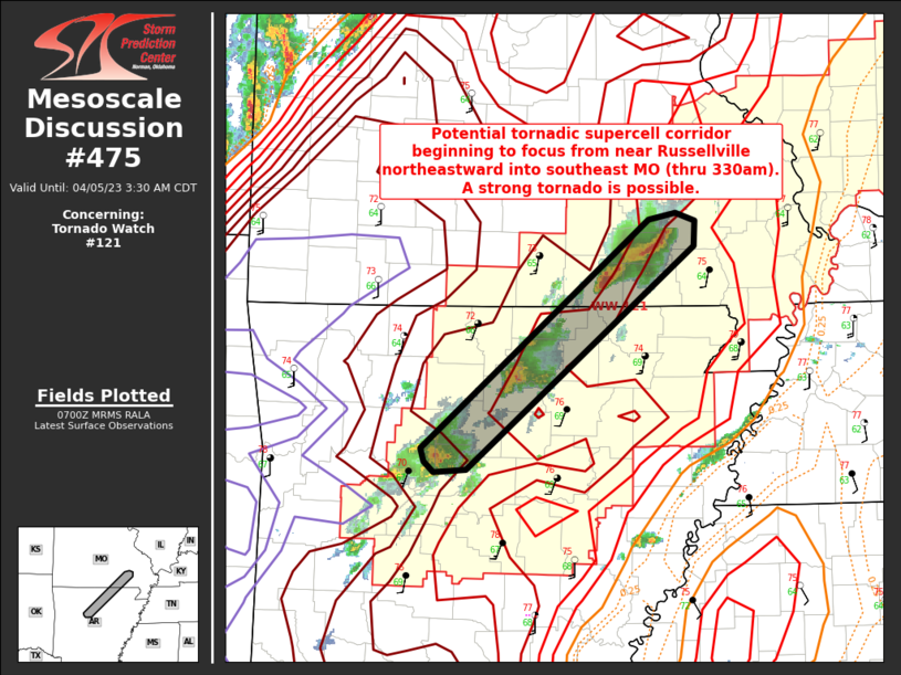 |
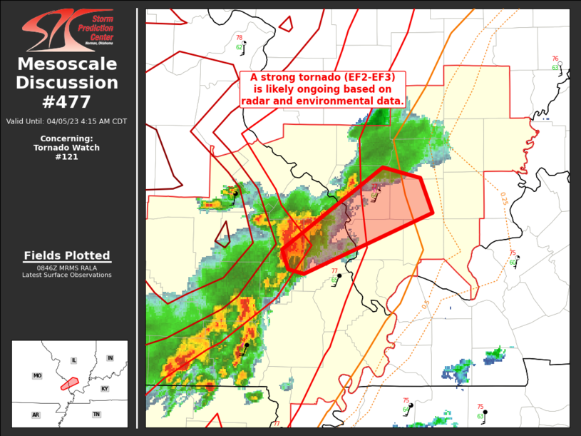 |
| SPC mesoscale graphic 474 | SPC mesoscale graphic 475 | SPC meso graphic 477 |
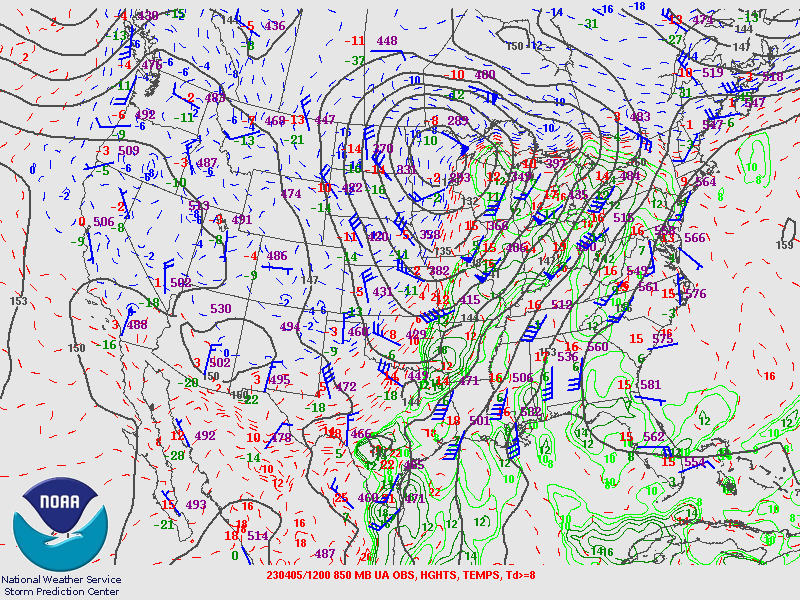
National surface and upper-air maps.
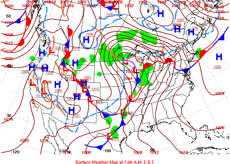 |
 |
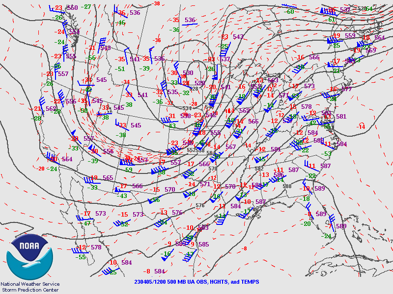 |
| Surface map 12z Apr 5 | 850 mb map 12z Apr 5 | 500 mb map: 12z Apr 5 |
 |
Media use of NWS Web News Stories is encouraged! Please acknowledge the NWS as the source of any news information accessed from this site. |
|