
A Moderate Risk of severe thunderstorms (level 4 of 5) is in the outlook across portions of the Midwest today. Damaging winds, a few tornadoes and frequent lightning with heavy rainfall are in the forecast. Meanwhile, dangerous heat across the southern Plains into the Great Lakes, mid-Atlantic and Northeast will expand into Friday. Risk for wildfires for the central Rockies and Sacramento Valley. Read More >
Near-blizzard conditions affected a large part of southern Illinois, as well as parts of southwest Indiana and southeast Missouri. The worst conditions occurred on Christmas night. A surface low pressure center moved northeast across Middle Tennessee. Strong winds and colder air on the northwest side of the low created a dangerous winter storm.
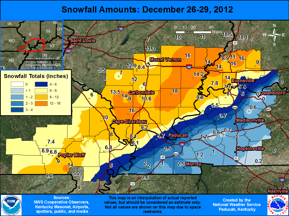
ILLINOIS...
The swath of the heaviest snow and near-blizzard conditions excluded only the far southeast counties of Massac and Hardin, as well as the far northwest counties of Jefferson and Perry. Elsewhere, visibility dropped to one-quarter to one-half mile for several hours in heavy snow. Winds frequently gusted from 25 to 35 mph.
Amounts were around a foot from northern Pope and Johnson Counties, northward across Marion and Harrisburg, to the Wabash Valley region, including Mount Carmel and Albion. Isolated amounts to 20 inches were observed near Albion. Just 4 or 5 inches fell in the southernmost county of Massac. Despite the wet, heavy consistency of the snow, some drifts from two to three feet were reported. The snow fell at a very heavy rate in localized bands, in some cases accompanied by thunder and lightning. Snowfall rates in the heaviest bands were from two to three inches per hour. Road conditions were snow-covered and hazardous. Snow plows were able to keep one lane passable on most major highways. Smaller rural roads were passable only in 4-wheel drive vehicles in the area of heaviest snow. Isolated power outages occurred due to the combination of strong winds and heavy wet snow on power lines.
INDIANA...
Near-blizzard conditions affected parts of southwest Indiana. The swath of the heaviest snow and near-blizzard conditions occurred north and west of the city of Evansville, where visibility dropped to one-quarter to one-half mile for several hours in heavy snow, and total snowfall amounts were around a foot. Snowfall amounts across the rest of southwest Indiana were from 6 to 10 inches, except for just 1 to 3 inches in the easternmost county of Spencer. Rain changed to snow from northwest to southeast, resulting in the highest accumulations north and west of Evansville. A quarter to half inch of sleet fell during the changeover in some places.
Winds frequently gusted from 25 to 35 mph across all of southwest Indiana. The snow fell at a very heavy rate in localized bands, in some cases accompanied by thunder and lightning. Snowfall rates in the heaviest bands were from two to three inches per hour. Road conditions were snow-covered and hazardous. Snow plows were able to keep one lane passable on most major highways. However, State Route 165 was reported to be impassable southwest of Owensville. Isolated power outages and downed tree limbs occurred due to the combination of strong winds and heavy wet snow. A state of emergency was declared in Posey County.
MISSOURI...
Near-blizzard conditions affected a large part of southeast Missouri. Total snowfall amounts were generally from 4 to 9 inches, except only 2 or 3 inches from Marble Hill to Perryville and points northwest. For an hour or two, visibility dropped to one-quarter mile in heavy snow, and winds gusted from 35 to 45 mph. Some drifts of two to three feet were reported. The snow fell at a very heavy rate in localized bands, in some cases accompanied by thunder and lightning. Snowfall rates in the heaviest bands were from two to three inches per hour. Road conditions were snow-covered and hazardous. Snow plows were able to keep one lane passable on most major highways. Isolated power outages occurred due to the combination of strong winds and heavy wet snow on power lines.
KENTUCKY...
Anywhere from 1 to 5 inches of snow fell across western Kentucky. The heaviest amounts were along the Ohio River, from west of Paducah to Henderson. Snowfall amounts were only an inch from the Hopkinsville area, westward across Cadiz, to Eddyville and Benton.The Owensboro area also received an inch or so. The remainder of western Kentucky generally received two to four inches. Rain changed to snow from northwest to southeast, resulting in the highest accumulations near the Ohio River. Winds frequently gusted from 25 to 35 mph. The wet, heavy consistency of the snow minimized drifting and blowing of the snow. Road conditions were snow-covered and hazardous. Numerous minor accidents and slide-offs were reported.

