Overview
A low pressure system strengthened as it moved northeast into the Great Lakes region. A large area of showers and thunderstorms associated with a warm front moved across our region during the afternoon of the 23rd. This resulted in heavy rain and some flooding in western Kentucky. Behind a trailing cold front, west winds gusted from 40 to 50 mph on the night of the 23rd.Flooding
A large mass of thunderstorms moved east across western Kentucky during the afternoon hours, dumping heavy rainfall on areas that were nearly saturated from a wet winter. The flash flooding resulted in some closed and flooded roads, a few flooded homes, and at least one water rescue from a vehicle. The hardest-hit areas were in the Kentucky counties bordering Tennessee, including the city of Murray.
PRELIMINARY LOCAL STORM REPORT...SUMMARY
NATIONAL WEATHER SERVICE PADUCAH KY
713 AM CST SUN FEB 24 2019
..TIME... ...EVENT... ...CITY LOCATION... ...LAT.LON...
..DATE... ....MAG.... ..COUNTY LOCATION..ST.. ...SOURCE....
..REMARKS..
0140 PM FLASH FLOOD CLINTON 36.67N 88.99W
02/23/2019 HICKMAN KY DEPT OF HIGHWAYS
WATER OVER HIGHWAY 58 NEAR THE FIRST BAPTIST
CHURCH.
0142 PM FLASH FLOOD 1 WNW CLINTON 36.67N 89.01W
02/23/2019 HICKMAN KY DEPT OF HIGHWAYS
WATER OF HIGHWAY 58 NEAR MILLS POOL.
0219 PM FLASH FLOOD LYNN GROVE 36.59N 88.44W
02/23/2019 CALLOWAY KY TRAINED SPOTTER
WATER OVER BROWNS GROVE ROAD, IN A LOCATION
THAT DOES NOT TYPICALLY FLOOD. REPORT
RELAYED VIA TWITTER.
0253 PM FLASH FLOOD MURRAY 36.61N 88.32W
02/23/2019 CALLOWAY KY BROADCAST MEDIA
FLOODING ON HALE ROAD AND ON SOUTH FOURTH
ST. IN MURRAY.
0318 PM FLASH FLOOD 4 ENE KIRKSEY 36.69N 88.36W
02/23/2019 CALLOWAY KY TRAINED SPOTTER
WATER IS UP TO AND ABOUT TO CROSS OVER THE
BRIDGE THAT CROSSES WEST FORK ROCK HOUSE
CREEK ON AIRPORT RD JUST SOUTH OF HWY 464.
0341 PM FLASH FLOOD 3 SSW CADIZ 36.83N 87.85W
02/23/2019 TRIGG KY BROADCAST MEDIA
WATER OVER PORTIONS OF OLD DOVER ROAD IN
TRIGG COUNTY.
0400 PM HEAVY RAIN 2 NW ROCKCASTLE 36.92N 88.01W
02/23/2019 M1.80 INCH LYON KY TRAINED SPOTTER
0407 PM FLASH FLOOD 5 NNW HAMLIN 36.66N 88.11W
02/23/2019 CALLOWAY KY EMERGENCY MNGR
ONE HOME WAS EVACUATED DUE TO FLOOD WATER ON
ROWLETT TRAIL.
0410 PM FLASH FLOOD 2 NNW MURRAY 36.63N 88.32W
02/23/2019 CALLOWAY KY PUBLIC
WATER RESCUE DUE TO VEHICLE STALLED IN FLOOD
WATER NORTH OF MURRAY STATE UNIVERSITY ON N.
16TH STREET.
0420 PM HEAVY RAIN 1 W MURRAY KY
2.56 INCHES OF RAIN BETWEEN 1230 PM AND 420 PM
0530 PM FLOOD NORTONVILLE 37.19N 87.45W
02/23/2019 HOPKINS KY EMERGENCY MNGR
WATER COVERED A FEW ROADS FROM NORTONVILLE
TO WHITE PLAINS.
0610 PM FLASH FLOOD ELKTON 36.81N 87.16W
02/23/2019 TODD KY EMERGENCY MNGR
HIGH WATER IS THREATENING A CHURCH AND A
COUPLE OF HOMES IN ELKTON. WATER COVERS
PORTIONS OF STATE ROADS 181, 848, AND 475,
AS WELL AS SEVERAL COUNTY ROADS ACROSS THE
COUNTY.
Strong winds
In the wake of a cold front, winds increased overnight Saturday night into early Sunday morning. Gusts to around 50 mph were observed. Isolated power outages were reported.
The following is a listing of wind gusts to at least 40 mph...
Issued 450 AM CST Sun Feb 24 2019

...Highest Winds reported so far in the Quad State Region...

The following observations show the highest wind gusts reported so far
from midnight through 5 am CST Sunday in the Quad State Region.

Location                     Speed     Time/Date       Lat/Lon
Carbondale IL                53 MPH    0211 AM 02/24   37.78N/89.25W
Paducah KY                   51 MPH    0314 AM 02/24   37.07N/88.77W
1 W Royalton                 50 MPH    0215 AM 02/24   37.88N/89.14W
10 N Perryville MO           49 MPH    0135 AM 02/24   37.87N/89.86W
Harrisburg IL                47 MPH    0415 AM 02/24   37.81N/88.55W
Evansville IN                47 MPH    0349 AM 02/24   38.04N/87.53W
Poplar Bluff MO              46 MPH    0134 AM 02/24   36.77N/90.32W
Carmi IL                     45 MPH    0357 AM 02/24   38.09N/88.12W
1 SW Heath                   45 MPH    0325 AM 02/24   37.07N/88.80W
Cape Girardeau MO            45 MPH    0201 AM 02/24   37.23N/89.57W
Hopkinsville KY 6 N          44 MPH    0400 AM 02/24   36.95N/87.52W
Henderson KY 5 E             44 MPH    0400 AM 02/24   37.82N/87.51W
Oakland City                 44 MPH    0356 AM 02/24   38.34N/87.35W
Henderson KY                 44 MPH    0355 AM 02/24   37.81N/87.68W
Cairo IL                     43 MPH    0315 AM 02/24   37.06N/89.22W
Marion KY                    43 MPH    0315 AM 02/24   37.34N/88.11W
Cadiz KY 4 SW                41 MPH    0415 AM 02/24   36.83N/87.86W
Morganfield KY 4 E           41 MPH    0415 AM 02/24   37.69N/87.84W
Mayfield KY 6 SW             41 MPH    0300 AM 02/24   36.70N/88.72W
Mt Vernon IL                 41 MPH    0237 AM 02/24   38.32N/88.86W
Hickman KY 2 E               41 MPH    0215 AM 02/24   36.57N/89.16W
3 SE Grand Tower             41 MPH    0140 AM 02/24   37.60N/89.46W
Princeton KY 2 SE            40 MPH    0415 AM 02/24   37.10N/87.86W
Madisonville KY              40 MPH    0415 AM 02/24   37.35N/87.40W
5 SE Hanson                  40 MPH    0415 AM 02/24   37.36N/87.40W
Mayfield KY                  40 MPH    0335 AM 02/24   36.78N/88.60W
Murray KY                    40 MPH    0335 AM 02/24   36.66N/88.37W
Benton KY 4 N                40 MPH    0325 AM 02/24   36.92N/88.34W
Sikeston Muni                40 MPH    0315 AM 02/24   36.90N/89.56W
1 W Miner                    40 MPH    0315 AM 02/24   36.90N/89.56W

Observations are collected from a variety of sources with varying
equipment and exposures. We thank all volunteer weather observers
for their dedication. Not all data listed are considered official.

$$
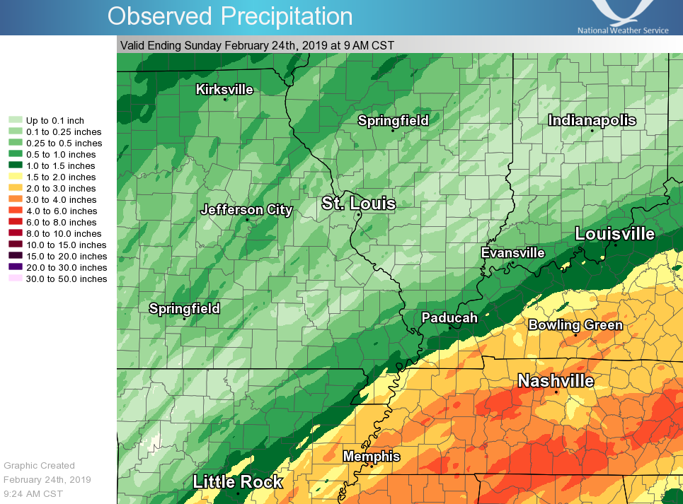
Rain Reports
Rainfall map for the 48-hour period from 9 AM Feb. 22 to 9 AM Feb. 24. An average of 2 to 4 inches fell in the Tennessee border counties of western Kentucky.
Environment
Click on images for full-size versions.
 |
 |
 |
| Figure 1: Surface pressure | Figure 2: 850 mb hghts / winds | Figure 3: 500 mb hghts / winds |
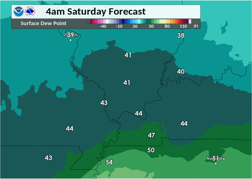
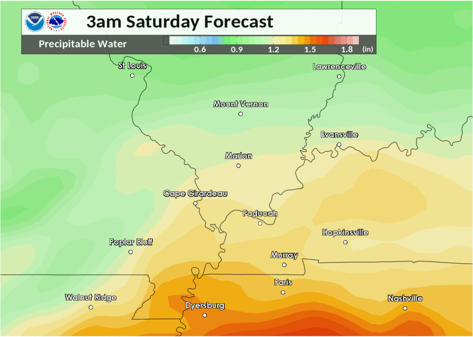
Near-storm environment summary.
 |
 |
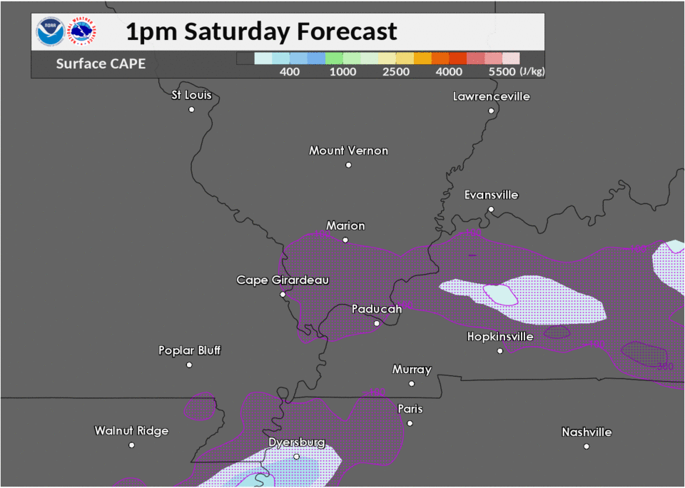 |
| Figure 4: Surface dew pts | Figure 5: Precip water values | Figure 6: Sfc cape / cin |
 |
Media use of NWS Web News Stories is encouraged! Please acknowledge the NWS as the source of any news information accessed from this site. |
|

