Overview
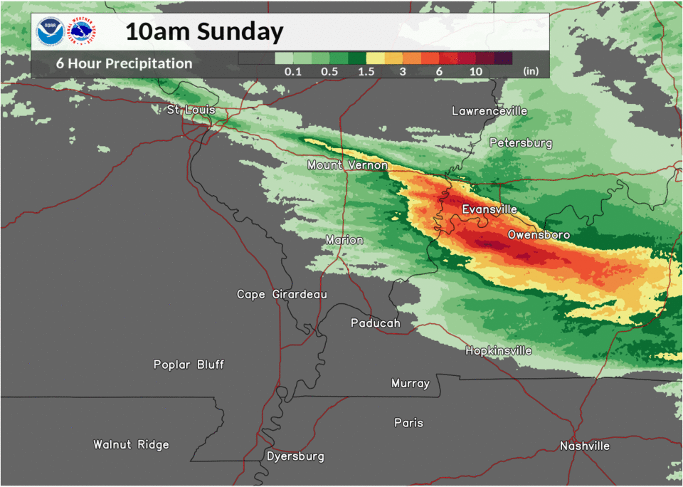
A series of thunderstorm complexes during the night of June 27th into the 28th produced significant flash flooding. A small swath of rainfall amounts of 4 to 8 inches occurred over portions of northwest Kentucky, just south of the cities of Owensboro and Henderson. Surrounding this area, parts of southwest Indiana, southeast Illinois, and the Pennyrile region of western Kentucky measured 2 to 4 inches in some areas.Flooding Impacts
Numerous water rescues were conducted on the morning of June 28 in Henderson, Daviess, and Mclean Counties in western Kentucky. Local government in Mclean County declared a state of emergency. Most of the water rescues involved vehicles stranded in floodwater. At least a few water rescues involved residents in their homes in Mclean County. Rainfall amounts were highest in southern Daviess, southern Henderson, and northern Mclean Counties. This area saw as much as 7.5 inches of rain. At the height of the rainfall event, many roads were impassable, including major routes such as Highway 431.
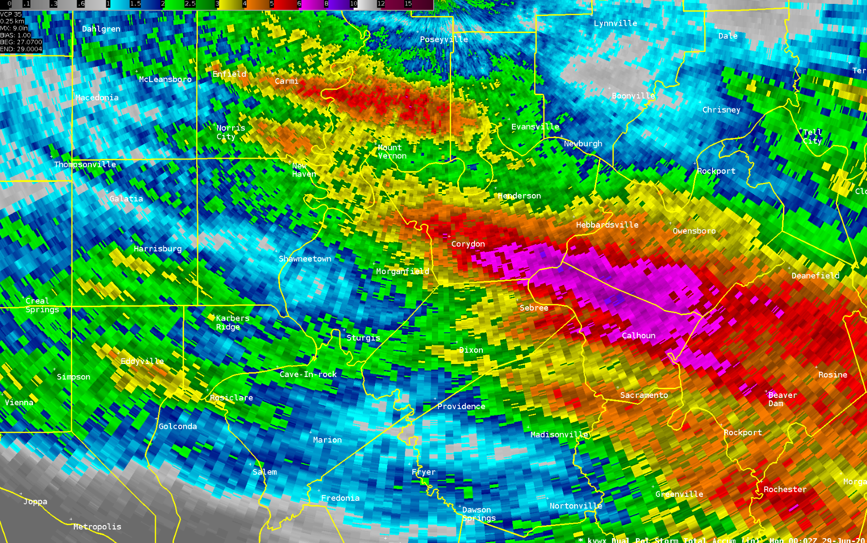
Below is a radar-estimated rainfall map from the Evansville radar, using the dual-polarization estimates. The estimates were somewhat lower than observed values by as much as 20 percent, but they still provide a useful depiction of the hardest-hit areas. The storm-total rainfall period includes June 27th through the daytime hours of the 28th. Purple shading denotes 6-inch plus amounts, red is 5-plus inches, and yellow is 3-plus inches.
Photos
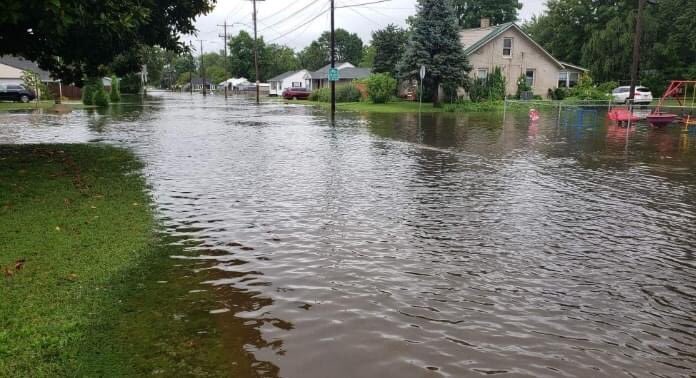
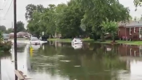
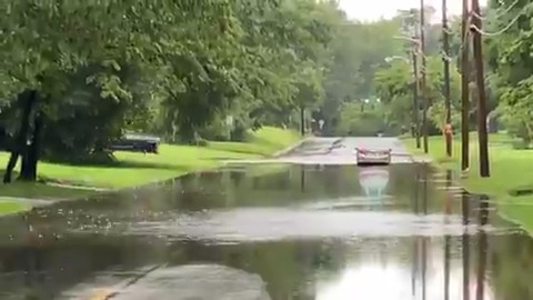
Flooding images (click for larger size)
 |
 |
 |
 |
| Owensboro street flooding (JR Miller and W. Byers) |
Stranded car in Owensboro (Chris Conley) |
Owensboro car stalled (Chris Conley) |
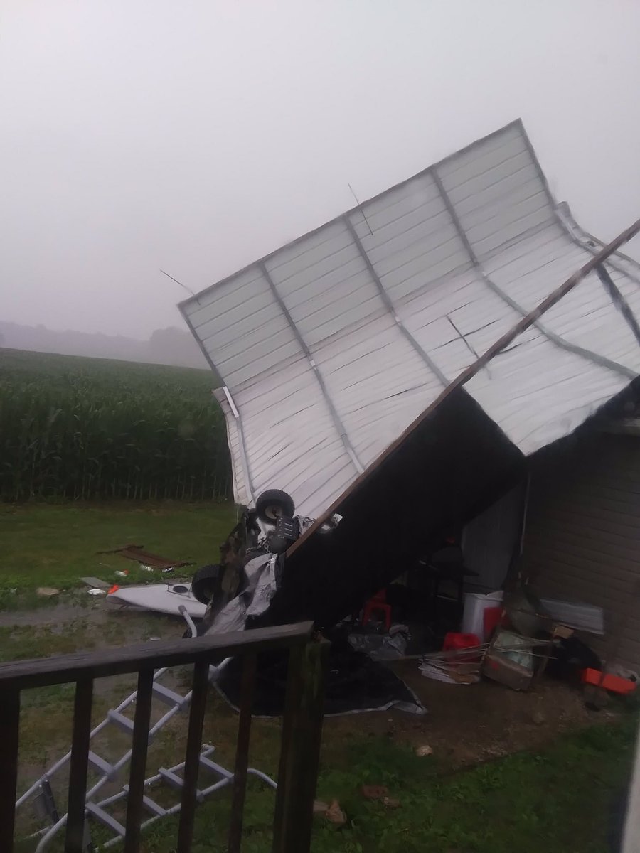
Carport flipped near Guthrie, KY (Justin Hogan/WHOP) |
Radar
Regional mosaics (click on images for larger size)
 |
 |
 |
 |
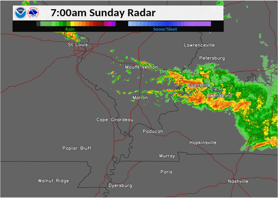
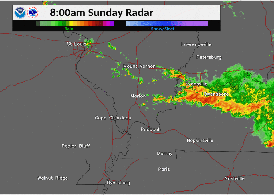
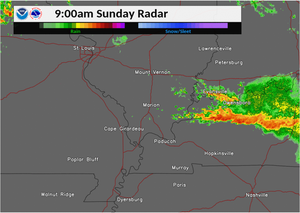
| 7 AM radar | 8 AM radar | 9 AM radar | 6-hour rainfall (radar estimate) |
Storm Reports
PRELIMINARY LOCAL STORM REPORT...SUMMARY
NATIONAL WEATHER SERVICE PADUCAH KY
850 PM CDT SUN JUN 28 2020

..TIME...   ...EVENT...      ...CITY LOCATION...     ...LAT.LON...
..DATE...   ....MAG....      ..COUNTY LOCATION..ST.. ...SOURCE....
            ..REMARKS..

0736 AM     HEAVY RAIN       UTICA                   37.60N 87.11W
06/28/2020  M3.34 INCH       DAVIESS            KY   TRAINED SPOTTER

            FLOODING OF FLOOD-PRONE AREAS. CARS STALLED
            OUT IN WATER.

0800 AM     FLASH FLOOD      HENDERSON               37.84N 87.58W
06/28/2020                   HENDERSON          KY   TRAINED SPOTTER

            TRAINED SPOTTER REPORTED AT 0800HRS THE
            INTERSECTION OF AIRLINE RD AND GARDEN MILE
            RD IN HENDERSON COUNTY IS FLOODED AND
            IMPASSABLE.

0815 AM     FLASH FLOOD      HENDERSON               37.84N 87.58W
06/28/2020                   HENDERSON          KY   BROADCAST MEDIA

            WATER RESCUES CONDUCTED DUE TO VEHICLES
            STRANDED IN FLOODWATERS.

0830 AM     HEAVY RAIN       DARMSTADT               38.10N 87.58W
06/28/2020  E5.00 INCH       VANDERBURGH        IN   PUBLIC

            APPROXIMATELY 5 INCHES IN THE PAST 24 HOURS.

0830 AM     HEAVY RAIN       NEWBURGH                37.95N 87.40W
06/28/2020  M2.30 INCH       WARRICK            IN   MESONET

            STORM TOTAL NEAR DEACONESS GATEWAY. 1.63
            SINCE MIDNIGHT.

0830 AM     HEAVY RAIN       GRANDVIEW               37.94N 86.98W
06/28/2020  M1.51 INCH       SPENCER            IN   MESONET

            STORM TOTAL. SINCE MIDNIGHT -- 0.74.

0830 AM     HEAVY RAIN       EVANSVILLE              37.98N 87.54W
06/28/2020  M3.51 INCH       VANDERBURGH        IN   MESONET

            DOWNTOWN EVANSVILLE IN STORM TOTAL. 2.88
            SINCE MIDNIGHT.

0836 AM     HEAVY RAIN       3 NE UTICA              37.60N 87.11W
06/28/2020  M5.34 INCH       DAVIESS            KY   TRAINED SPOTTER

            AMENDS PREVIOUS HEAVY RAIN REPORT (STORM
            TOTAL) FROM 3 MILES NORTHEAST OF UTICA.
            FLOODING OF FLOOD-PRONE AREAS. CARS STALLED
            OUT IN WATER.

0836 AM     FLOOD            5 E MAUNIE              38.01N 87.97W
06/28/2020                   POSEY              IN   PUBLIC

            REPORT FROM MPING: CROPLAND/YARD/BASEMENT
            FLOODING.

0841 AM     FLASH FLOOD      CALHOUN                 37.54N 87.26W
06/28/2020                   MCLEAN             KY   PUBLIC

            UP TO 4.38 INCHES OF RAIN HAS FALLEN IN
            CALHOUN. DITCHES ARE OVERFLOWING, AND ROADS
            ARE FLOODING. MAIN STREET IN CALHOUN IS
            FLOODED.

0845 AM     FLASH FLOOD      OWENSBORO               37.76N 87.12W
06/28/2020                   DAVIESS            KY   BROADCAST MEDIA

            NUMEROUS WATER RESCUES CONDUCTED DUE TO
            VEHICLES IN FLOODWATERS ACROSS THE COUNTY,
            INCLUDING THE CITY OF OWENSBORO.

0845 AM     FLASH FLOOD      CALHOUN                 37.54N 87.26W
06/28/2020                   MCLEAN             KY   911 CALL CENTER

            SEVERAL WATER RESCUES WERE CONDUCTED,
            INCLUDING A FEW FROM HOMES AND A FEW FROM
            VEHICLES. MAJOR ROADS WERE CLOSED, INCLUDING
            HIGHWAYS 431, 136, AND 80. MAJORITY OF
            EMERGENCIES WERE FROM 845 TO 10 AM. WATER
            WAS GENERALLY RECEDING AS OF MID AFTERNOON.

0900 AM     HEAVY RAIN       CALHOUN                 37.55N 87.26W
06/28/2020  M5.59 INCH       MCLEAN             KY   MESONET

            STORM TOTAL THROUGH 9AM.

0908 AM     HEAVY RAIN       1 W CARMI               38.09N 88.19W
06/28/2020  M4.18 INCH       WHITE              IL   PUBLIC


0926 AM     HEAVY RAIN       3 ESE EVANSVILLE        37.97N 87.49W
06/28/2020  M3.00 INCH       VANDERBURGH        IN   TRAINED SPOTTER

            STORM TOTAL AT CORNER OF WASHINGTON AND
            VANN. SOME WATER COVERING PARTS OF ROADS.

1224 PM     HEAVY RAIN       CENTRAL CITY            37.30N 87.13W
06/28/2020  E4.50 INCH       MUHLENBERG         KY   PUBLIC

            MOST OF THIS RAIN FELL SINCE 930AM. STREET FLOODING.

1229 PM     HEAVY RAIN       4 ENE OWENSBORO         37.78N 87.06W
06/28/2020  M2.12 INCH       DAVIESS            KY   CO-OP OBSERVER

            2.12 INCHES SINCE 630AM TODAY. TOTAL SINCE
            YESTERDAY MORNING IS 4.65 INCHES (30 HOUR
            TOTAL).

1243 PM     HEAVY RAIN       2 SW EVANSVILLE         37.97N 87.57W
06/28/2020  M3.80 INCH       VANDERBURGH        IN   CO-OP OBSERVER

            REPORTED AT EVANSVILLE MUSEUM. 20 HOUR TOTAL
            (SINCE 4PM YESTERDAY).

0124 PM     FLOOD            3 NW NEWBURGH           37.98N 87.43W
06/28/2020                   WARRICK            IN   PUBLIC

            REPORT FROM MPING. CROPLAND/YARD/BASEMENT
            FLOODING.

0234 PM     HEAVY RAIN       6 ESE EVANSVILLE        37.95N 87.44W
06/28/2020  M3.00 INCH       WARRICK            IN   TRAINED SPOTTER

            18 HOUR STORM TOTAL.

0350 PM     HEAVY RAIN       4 ESE CORYDON           37.71N 87.65W
06/28/2020  M7.85 INCH       HENDERSON          KY   TRAINED SPOTTER

            RAIN TOTAL SINCE 530AM.

0354 PM     FLASH FLOOD      CALHOUN                 37.54N 87.26W
06/28/2020                   MCLEAN             KY   PUBLIC

            SOME STREETS AND HIGHWAYS ARE STILL CLOSED
            DUE TO FLOODING. SOME DITCHES ARE
            OVERFLOWING. THE GREEN RIVER DOCK IS
            SEVERELY FLOODED.

0410 PM     FLOOD            2 N ELKTON              36.84N 87.16W
06/28/2020                   TODD               KY   PUBLIC

            REPORT FROM MPING. CROPLAND/YARD/BASEMENT
            FLOODING.

0430 PM     TSTM WND GST     5 SW ELKTON             36.76N 87.22W
06/28/2020  M65 MPH          TODD               KY   MESONET

            KENTUCKY MESONET SITE.
Rain Reports
Public Information Statement
National Weather Service Paducah KY
910 PM CDT Sun Jun 28 2020

...SELECT 48 hour PRECIPITATION REPORTS...

Location                     Amount    Time/Date       Provider

...Illinois...

...Edwards County...
Albion                       1.40 in   0846 PM 06/28   CWOP

...Jackson County...
Carbondale IL                1.24 in   0852 PM 06/28   ASOS
Grand Tower                  1.16 in   0800 PM 06/28   HADS
1 NW Campbell Hill IL        0.51 in   0900 PM 06/28   AWS

...Jefferson County...
Scheller                     0.88 in   0855 PM 06/28   CWOP

...Perry County...
Pinckneyville IL             0.34 in   0859 PM 06/28   AWS

...Wabash County...
Mount Carmel IL              1.52 in   0859 PM 06/28   AWS

...Wayne County...
Fairfield IL                 0.77 in   0855 PM 06/28   CWOP

...Williamson County...
Marion IL                    1.27 in   0859 PM 06/28   AWS

...Indiana...

...Gibson County...
1.6 SE Mount Carmel          3.10 in   0845 PM 06/28   COOP
Oakland City IN              0.93 in   0857 PM 06/28   CWOP

...Posey County...
Mt. Vernon                   4.47 in   0845 PM 06/28   CWOP
Mount Vernon IN              3.60 in   0859 PM 06/28   CWOP
Wadesville                   2.22 in   0855 PM 06/28   CWOP
7 E Mount Vernon IN          2.20 in   0859 PM 06/28   AWS
Mount Vernon IN              2.16 in   0859 PM 06/28   AWS

...Vanderburgh County...
2.0 W Evansville             3.84 in   0800 PM 06/28   COOP
Evansville                   3.60 in   0856 PM 06/28   CWOP
Evansville IN                3.13 in   0854 PM 06/28   ASOS
2 W Evansville IN            2.96 in   0859 PM 06/28   AWS

...Warrick County...
Newburgh IN                  2.46 in   0855 PM 06/28   CWOP
Newburgh IN                  2.40 in   0846 PM 06/28   CWOP

...Kentucky...

...Caldwell County...
4.3 W Cerulean               0.87 in   0300 PM 06/28   HADS
Princeton 2 SE               0.61 in   0855 PM 06/28   KYMN2

...Christian County...
3.4 E Hopkinsville           2.43 in   0800 PM 06/28   HADS
1.8 NE Hopkinsville          1.59 in   0815 PM 06/28   HADS
Hopkinsville 6 N             1.26 in   0855 PM 06/28   KYMN2
1 N Hopkinsville KY          1.10 in   0859 PM 06/28   AWS

...Crittenden County...
Marion 4 NE                  1.32 in   0855 PM 06/28   KYMN2

...Henderson County...
Henderson 5 E                3.48 in   0855 PM 06/28   KYMN2
Henderson KY                 3.42 in   0856 PM 06/28   AWOS


...McLean County...
Calhoun 5 NW                 6.74 in   0855 PM 06/28   KYMN2
Livermore                    4.14 in   0800 PM 06/28   HADS

...Muhlenberg County...
Greenville 6 N               5.52 in   0855 PM 06/28   KYMN2

...Todd County...
Elkton KY                    2.68 in   0845 PM 06/28   CWOP
Elkton 5 SW                  2.59 in   0855 PM 06/28   KYMN2
1.9 S Elkton                 2.25 in   0500 PM 06/28   HADS

...Union County...
Morganfield 4 E              2.59 in   0850 PM 06/28   KYMN2

Observations are collected from a variety of sources with varying
equipment and exposures. We thank all volunteer weather observers
for their dedication. Not all data listed are considered official.
 |
Media use of NWS Web News Stories is encouraged! Please acknowledge the NWS as the source of any news information accessed from this site. |
|

