Overview
A fairly well-organized complex of thunderstorms moved east-southeast across the Mid-Mississippi Valley into the Tennessee Valley during the evening of the 9th. A few supercells were embedded in the complex. The longest-track supercell produced tornadoes along a track from south of Poplar Bluff, MO to Fulton County, Kentucky. In all, a total of 10 tornadoes have been confirmed. The strongest tornadoes were rated EF-2 in Fulton County, KY, New Madrid Co, MO, and Ripley Co., MO.Tornadoes:
|
|
||||||||||
|
||||||||||
|
Tornado 1 - Hickman, KY
Track Map 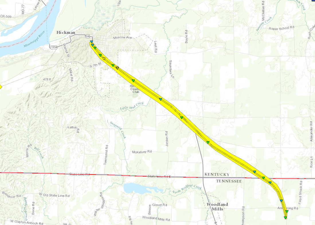 
|
||||||||||||||||||||||
|
Tornado 2 - West of Hickman, KY
Track Map 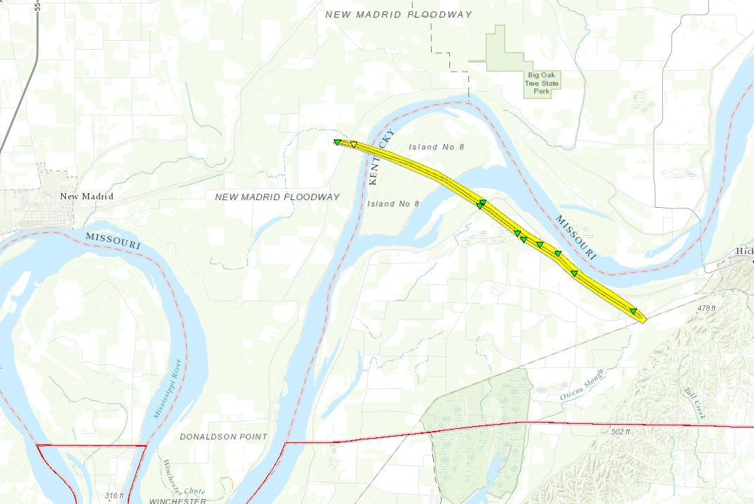
|
||||||||||||||||||
|
Tornado 3 - Near Murray, KY
Track Map 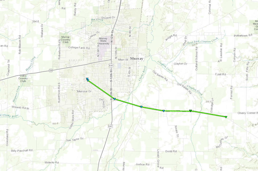
|
||||||||||||||||
|
Tornado 4 - Broseley, MO
Track Map 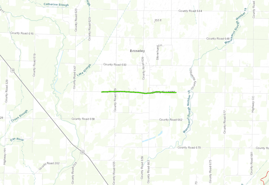
|
||||||||||||||||
|
Tornado 5 - Bernie, MO
Track Map 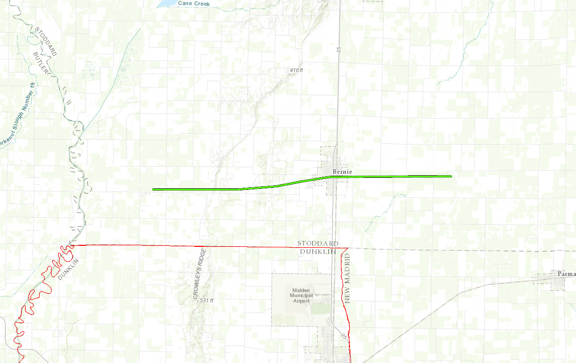
|
||||||||||||||||
|
Tornado 6 - Kewanee, MO
Track Map 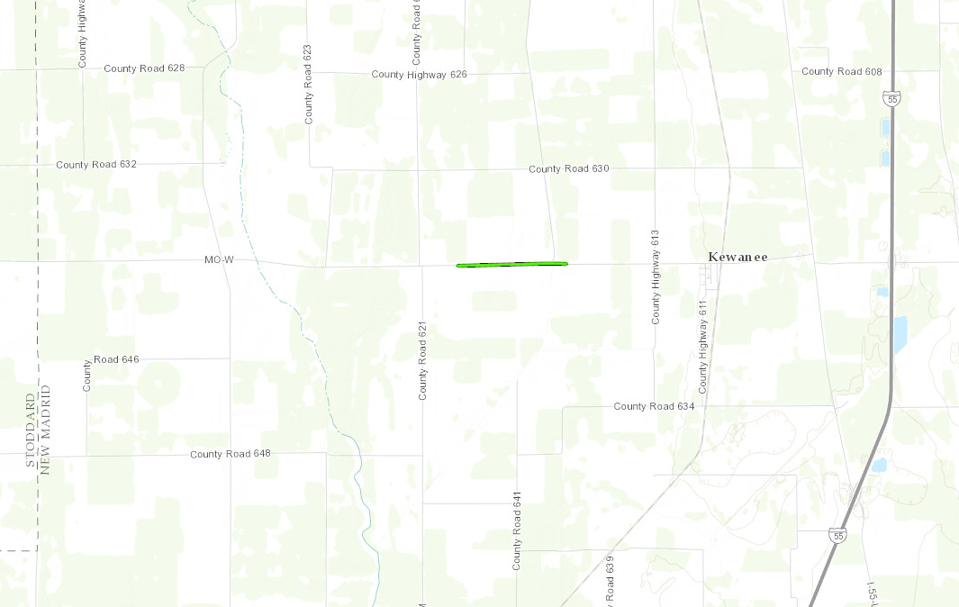
|
||||||||||||||||
|
Tornado 7 - Near Parma, MO
Track Map 
|
||||||||||||||||
|
Tornado 8 - Near Poplar Bluff
Track Map 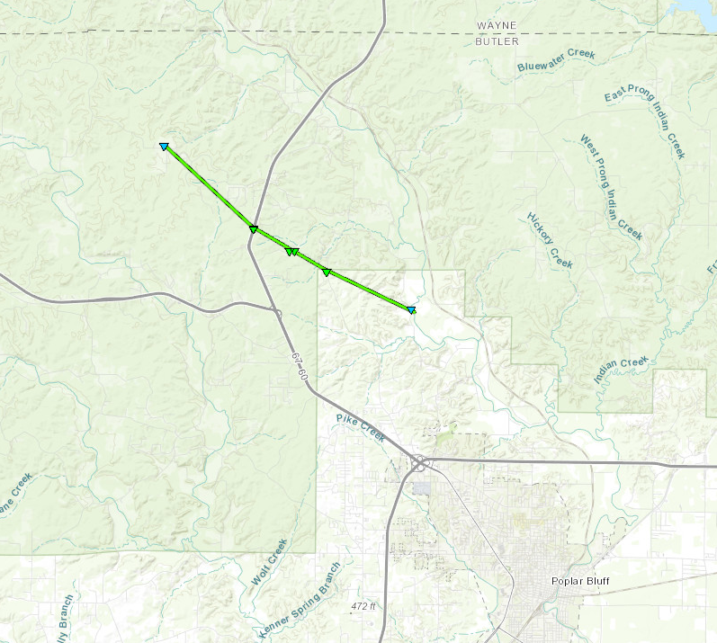
|
||||||||||||||||
|
Tornado 9 - NW of Dudley, MO
Track Map 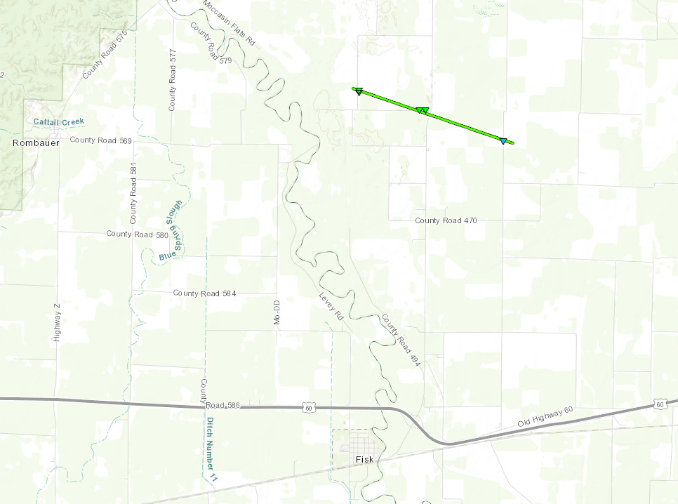
|
||||||||||||||||
|
Tornado 10 - North of Doniphan, MO
Track Map 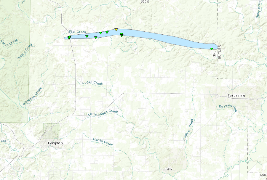
|
||||||||||||||||
The Enhanced Fujita (EF) Scale classifies tornadoes into the following categories:
| EF0 Weak 65-85 mph |
EF1 Moderate 86-110 mph |
EF2 Significant 111-135 mph |
EF3 Severe 136-165 mph |
EF4 Extreme 166-200 mph |
EF5 Catastrophic 200+ mph |
 |
|||||
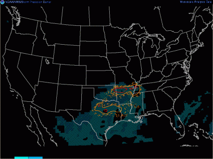
Radar:
Click here for a radar loop of this event
 |
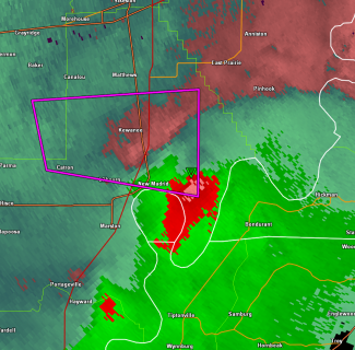 |
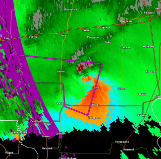
 |
| Paducah radar base wind velocity, showing the circulation center just east of Bernie, MO at 7:50 PM CST. Tornado warning polygon is in purple. | Paducah radar storm-relative wind, showing the circulation approaching the Mississippi River at 8:19 PM CST. Tornado warning polygon in purple. | Paducah dual-pol correlation coefficient (cc). This indicates a TDS (Tornado Debris Signature) on the Mississippi River west of Hickman at 8:27 PM.. |
Storm Reports
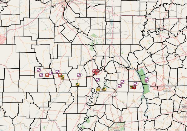
PRELIMINARY LOCAL STORM REPORT...SUMMARY
NATIONAL WEATHER SERVICE PADUCAH KY
726 AM CST SAT MAR 11 2017

..TIME...   ...EVENT...      ...CITY LOCATION...     ...LAT.LON...
..DATE...   ....MAG....      ..COUNTY LOCATION..ST.. ...SOURCE....
            ..REMARKS..

0525 PM     HAIL             EASTWOOD                36.89N 91.03W
03/09/2017  E0.75 INCH       CARTER             MO   FIRE DEPT/RESCUE

0530 PM     HAIL             5 W VAN BUREN           37.01N 91.10W
03/09/2017  E0.75 INCH       CARTER             MO   TRAINED SPOTTER

0557 PM     FUNNEL CLOUD     HUNTER                  36.89N 90.85W
03/09/2017                   CARTER             MO   PUBLIC

0610 PM     HAIL             ELLSINORE               36.93N 90.75W
03/09/2017  E1.75 INCH       CARTER             MO   LAW ENFORCEMENT

0615 PM     HAIL             WILLIAMSVILLE           36.97N 90.55W
03/09/2017  E0.75 INCH       WAYNE              MO   TRAINED SPOTTER

0640 PM     FUNNEL CLOUD     1 SW HENDRICKSON        36.89N 90.48W
03/09/2017                   BUTLER             MO   TRAINED SPOTTER

            2 MILES SOUTH OF WAYNE/BUTLER COUNTY LINE.

0650 PM     TSTM WND DMG     4 N POPLAR BLUFF        36.82N 90.41W
03/09/2017                   BUTLER             MO   TRAINED SPOTTER

            TREE AND POWER LINE DAMAGE

0652 PM     TSTM WND DMG     6 N POPLAR BLUFF        36.85N 90.41W
03/09/2017                   BUTLER             MO   EMERGENCY MNGR

            SEVERAL TREES AND ROAD SIGNS DOWN ON HIGHWAY 67.

0722 PM     HAIL             1 SW MAYFIELD           36.73N 88.66W
03/09/2017  E1.00 INCH       GRAVES             KY   TRAINED SPOTTER

0725 PM     HAIL             NNE WINGO               36.64N 88.74W
03/09/2017  E0.88 INCH       GRAVES             KY   TRAINED SPOTTER

0735 PM     HAIL             BLOOMFIELD              36.89N 89.93W
03/09/2017  E1.00 INCH       STODDARD           MO   TRAINED SPOTTER

            NORTHWEST SIDE OF TOWN

0740 PM     HAIL             MURRAY                  36.61N 88.32W
03/09/2017  E1.00 INCH       CALLOWAY           KY   EMERGENCY MNGR

0746 PM     HAIL             MURRAY                  36.61N 88.32W
03/09/2017  E1.00 INCH       CALLOWAY           KY   EMERGENCY MNGR

            KY HIGHWAY 94 AND 280

0747 PM     HAIL             MURRAY                  36.61N 88.32W
03/09/2017  E1.00 INCH       CALLOWAY           KY   EMERGENCY MNGR

0750 PM     TSTM WND DMG     BERNIE                  36.67N 89.97W
03/09/2017                   STODDARD           MO   TRAINED SPOTTER

            POSSIBLE TORNADO? ON THE WEST SIDE OF BERNIE THERE WERE
            SEVERAL GRAIN BINS DAMAGED. HE SAW PICTURES OF A HOUSE
            WITH SEVERE DAMAGE. BETWEEN BERNIE AND MALDEN THERE WERE
            POWERPOLES ACROSS THE ROADWAY ALONG WITH POWERLINES.

0755 PM     HAIL             ALMO                    36.69N 88.28W
03/09/2017  E1.00 INCH       CALLOWAY           KY   TRAINED SPOTTER

0810 PM     HAIL             3 S CANTON              36.76N 87.96W
03/09/2017  E1.00 INCH       TRIGG              KY   EMERGENCY MNGR

0822 PM     TSTM WND GST     10 W HICKMAN            36.56N 89.37W
03/09/2017  M85.00 MPH       FULTON             KY   TRAINED SPOTTER

            TREES UPROOTED OR SNAPPED

0825 PM     HAIL             CANTON                  36.80N 87.96W
03/09/2017  E0.88 INCH       TRIGG              KY   TRAINED SPOTTER

0830 PM     HAIL             EAST PRAIRIE            36.78N 89.38W
03/09/2017  E0.75 INCH       MISSISSIPPI        MO   TRAINED SPOTTER

0837 PM     HAIL             1 W MURRAY              36.61N 88.33W
03/09/2017  E0.75 INCH       CALLOWAY           KY   TRAINED SPOTTER

0840 PM     HEAVY RAIN       DIEHLSTADT              36.96N 89.43W
03/09/2017  E2.62 INCH       SCOTT              MO   TRAINED SPOTTER

            FELL MOSTLY WITHIN ONE HOUR.

0841 PM     TORNADO          HICKMAN                 36.56N 89.19W
03/09/2017                   FULTON             KY   EMERGENCY MNGR

            POSSIBLE TORNADO DAMAGE IN TOWN INCLUDING AT THE DISPATCH
            CENTER. DONT KNOW THE EXTENT OF THE DAMAGE AT THIS TIME.
            SPOTTER ALSO REPORTED FUNNEL CLOUD EAST OF HICKMAN SOUTH
            OF HWY 94

0845 PM     TSTM WND DMG     HICKMAN                 36.56N 89.19W
03/09/2017                   FULTON             KY   TRAINED SPOTTER

            TELEPHONE AND ELECTRIC POLES DOWN IN DOWNTOWN HICKMAN

0920 PM     TSTM WND DMG     4 W MURRAY              36.61N 88.39W
03/09/2017                   CALLOWAY           KY   EMERGENCY MNGR

            POWER LINE DOWN BETWEEN MURRAY AND LYNN GROVE

0925 PM     TSTM WND DMG     MURRAY                  36.61N 88.32W
03/09/2017                   CALLOWAY           KY   EMERGENCY MNGR

            SEVERAL TREES DOWN NEAR HIGH SCHOOL. BASEBALL DUGOUT ROOF
            BLOWN OFF. CHAIN FENCE DOWN. TIME ESTIMATED


&&

$$
Environment
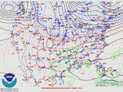
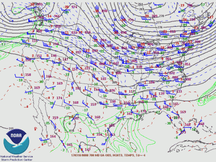
A 500 mb shortwave trough approached the Mississippi Valley. In advance of the trough, a moderately strong 850 mb southwest flow brought plenty of moisture and instability northeast.
 |
 |
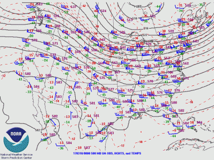 |
| Figure 1: 850 mb map (00z Mar 10) | Figure 2: 700 mb map (00z Mar 10) | Figure 3: 500 mb map (00z Mar 10) |
Near-storm environment summary.
 |
 |
 |
| Figure 4: Sfc-based cape | Figure 5: Supercell composite parameter | Figure 6: Significant tor parameter |
Additional environmental data.
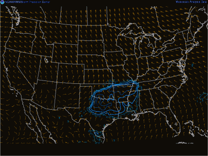
.gif/wpc_20170310_0000(1)__427x320.gif) |
 |
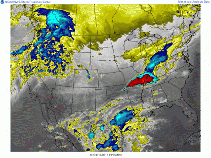 |
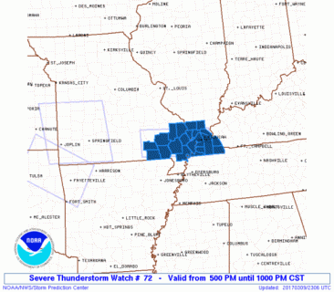
| Figure 7: Sfc map (00z Mar 10) | Figure 8: Svr Tstm Watch 72 | Figure 9: IR satellite |
 |
Media use of NWS Web News Stories is encouraged! Please acknowledge the NWS as the source of any news information accessed from this site. |
|