On this page you learn what types of flooding are typical in Louisiana and how do you protect yourself, your family and your home. You will also find out more about significant Louisiana floods. Finally, you'll find links to NWS offices that provide forecast and safety information for Louisiana, as well as links to our partners who play a significant role in keeping you safe.
Deaths: 246 flood-related deaths in several states
Impacts: Over 700,000 homeless in several states
Costs: Property damage was estimated at over $400 million dollars (1927 dollars), equivalent to over $5 billion dollars today.
The Great Mississippi Flood of 1927 was the most destructive flood in U.S. history. This flood extended across Illinois, Indiana, Missouri, Kentucky, Texas, Oklahoma, Kansas, Tennessee, Arkansas, Mississippi, and Louisiana. At one point the Mississippi River was approximately 80 miles wide near Vicksburg, MS.
According to the Louisiana Flood Insurance brochure, flood waters and damage in Louisiana was spread over 20 parishes consisting of a total of 10,000 square miles. New Orleans had 11.16 inches of February rainfall and that rainfall increased through March and the first half of April. On April 15--Good Friday--in excess of 14 inches deluged the city and overwhelmed the city's drainage pumps.
The political ramifications of this flood exacerbated the Great Migration of African-Americans from the impacted southern states to northern states. Conditions were harsher on the residents of Mississippi, where men were forced at gunpoint to rebuild the levees. In southeastern Louisiana, St. Bernard and Plaquemines Parishes were purposely flooded, when dynamite destroyed the Mississippi River levee at Caernarvon, LA to protect the city of New Orleans from the flooding.
National politics were impacted by the failure of the Republican politicians, particularly former Secretary of Commerce and President-elect, Herbert Hoover, to deliver on promises to African- Americans made during the elections of 1928. In upstate Louisiana, anger at the New Orleans elite aided Huey Long’s election to the governorship in 1928.[As a result, the political affiliations of many African-Americans switched from the Republican Party to Democratic Party.
Property damage was estimated at $350 million dollars, equivalent to approximately $5 billion dollars today. Economic losses were estimated at $1 billion (1927 dollars), which was equivalent to almost one-third of the federal budget at that time.
Learn More:
Deaths: Around 40 people in Louisiana, total of about 75 people
Injuries: Unknown
Costs: $1.4 Billion (1965 dollars) or $8.5 Billion
Hurricane Betsy tracked across the Windward Islands, the Bahamas, and southern Florida before moving into the Gulf of America. Hurricane Betsy made landfall near Grand Isle, LA, on the night of September 9, 1965, as a Category 3 hurricane with winds over 140 miles an hour.
While in the Gulf of America, Hurricane Betsy destroyed several offshore oil platforms, including one owned by the Shell Oil Corporation. Several other oil platforms had damages. The oil rig owned by Zapata Corporation was lost during the storm. That rig was insured for 5.7 million (1965 dollars) and was owned by the future President of the United States, George H. W. Bush.
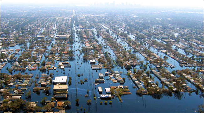
According to the Time Picayune newspaper, Hurricane Betsy’s damages were widespread and heavily felt. Several southeastern Louisiana communities were devastated, particularly in St. Bernard and Plaquemines Parishes. New Orleans was flooded for about 10 days. There were breaches on both sides of the Industrial Canal during Betsy. In the storm's aftermath, the federal government sent trailers to house displaced families. The Times Picayune reported the remarkable similarity to Hurricane Katrina. The story stated, “The storm became the first billion-dollar hurricane, causing $1.2 billion in damage. In response to Betsy, Congress ordered the Army Corps of Engineers to build a massive flood-protection system for New Orleans. That system fell apart 40 years later during Hurricane Katrina.”
Strong winds and heavy rainfall caused significant crop damage in Harrison, Hancock County, and Jackson counties, MS. Throughout the state, 25,000 people lost electricity and more than 22,641 disruptions to telephone service occurred. Overall, damage in the state of Mississippi totaled to $80 million (1965 USD), according to Wikipedia
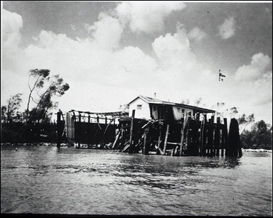 |
| Damaged U.S. Quarantine Station in New Orleans. Source: U.S. National Library of Medicine website. |
Learn More:
Deaths: Approximately 20 in several states; Army Corps of Engineers reported no deaths.
Injuries: No reports on injured found.
Costs: About $2 to $4 Billion (2011 dollars)
Impacts: Approximately 3,500 people were evacuated in the Atchafalaya River Basin; estimated that one-third of Wilkerson County, MS, flooded.
The massive flooding that developed during the early spring of 2011 rivaled the Mississippi River Floods of 1927 and 1937, according to the Encyclopedia Britannica. According to the article, “Concerns that the levees could be breached in the Louisiana cities of Baton Rouge and New Orleans--displacing thousands of people and shutting down a network of petroleum refineries that accounted for a substantial portion of domestic gasoline production--led to the opening of two spillways in May. With waters approaching the 1.25 million cubic feet (35,000 cubic meters) per second rate that indicated a possible risk to the cities, on May 9 the Bonnet Carre Spillway, approximately 30 miles (50 km) north of New Orleans, was partially opened, allowing overflow into Lake Pontchartrain, which drains into the Gulf of America. Further channels were opened the following days. On May 14 the Morganza Spillway, about 35 miles (56 km) north of Baton Rouge, was partially opened before more channels opened in the ensuing days. Nearly 3,500 people were evacuated. Those waters drained into the Atchafalaya River basin, covering some 3,000 square miles (7,770 square km), much of it cropland.”
In all, the diversion of flow into Lake Pontchartrain and eventually the Gulf of America waylaid the worst of the flooding, particularly after the opening of the Morganza Spillway by the Army Corps of Engineers. Approximately 3,000 square miles of cropland was flooded within the lower portion of the Atchafalaya River basin. The flooding impacts of St. Mary, St. Landry, Avoyelles, Iberia, and St. Martin Parishes were far less than what would have occurred without the diversion of the flood waters.
Major costs associated with this flood were suffered by farming and fishing sectors, the petrochemical industry, and by the river boat/barge and shipping industries which operate along the Ohio, Missouri, and Mississippi Rivers. From the Corps of Engineers report, “Total flood damage estimates from the 2011 Flood, totaled over $2.8 billion in urban and agricultural damages.” Environmental impacts included damage to coastal estuaries, displacement of native fauna, and ongoing impacts of reduced salinity in Lakes Maurepas and Pontchartrain. According the Corps’ report, the flood adversely impacted the oyster industry in the Mississippi Sound, Lake Borgne, and Breton Sound in Louisiana. Economic losses to the oyster industry in Mississippi alone in 2011 were approximately $60 million, according to the report.
New flood records were recorded upstream along the Mississippi River at Natchez and Vicksburg, MS. Roughly one-third of Wilkinson County was flooded in May 2011. A new record stage was set at Knox Landing, LA, where the Mississippi River rose to 66.26 feet on May 18th. On that same date, the flood waters rose to a new record stage of 63.39 feet at Red River Landing. A recently-established gauge on the Mississippi River at St. Francisville, LA set a new flood record of 53.48 feet on May 18th, as well.
Learn More:
Deaths: 6
Injuries: Unknown
Impacts: $3.1 billion
Starting on May 8, 1995, severe floods caused extensive damage in southeastern Louisiana and southern Mississippi. The floods shut down the New Orleans metropolitan area, after storm totals of 10 to 20 inches fell over the region.
The May 1995 floods were more extensive and damaging than the Easter Floods of 1979 and the Floods of 1989. The May 1995 flooding was more costly than these two events combined. There has been no comparable recorded flood in New Orleans caused by rain alone.
New Orleans suffered $360 million in damages, and the damage of the surrounding areas put that total above $3 billion, according to National Weather Service. Some 56,000 homes were damaged in 12 Parishes. Thousands of cars were flooded. 14,600 homes and apartments were flooded in Jefferson Parish alone. Rain totals from this event include:
Learn More:
|
||||||


