Overview
|
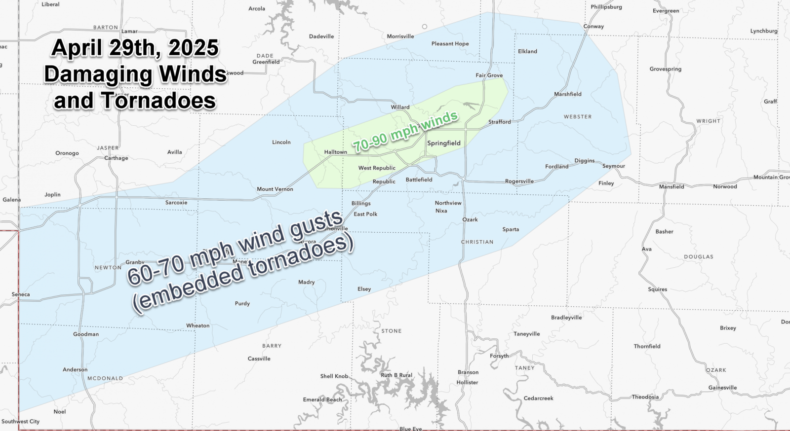
A cluster of severe thunderstorms moved through southwest Missouri on the morning of April 29th, 2025. Widespread wind damage and several tornadoes occurred. Significant wind damage with over 50,000 power outages occurred in Springfield alone. Numerous trees, powerlines and structures sustained damage from this system. A 90 mph wind gust was measured at the Springfield Branson National Airport. |
 Thunderstorm Winds |
Tornadoes
Select a tornado from the table to zoom into the track and view more information. The default table view is limited to 8 tracks, but can be scrolled by a mouse wheel or dynamically expanded. Additionally, the table can fill the entire window by clicking the small circular expanding arrow icon at the very top right of the table and returned to its original size by clicking the button again. The side information panel that opens over the map can be closed using the "X" on the upper right corner of the pop-up. Zoom into the map and click damage points to see detailed information and pictures from the surveys.
|
NOTE: times shown below are local to your device's time zone. |

The Enhanced Fujita (EF) Scale classifies tornadoes into the following categories:
| EF0 Weak 65-85 mph |
EF1 Moderate 86-110 mph |
EF2 Significant 111-135 mph |
EF3 Severe 136-165 mph |
EF4 Extreme 166-200 mph |
EF5 Catastrophic 200+ mph |
 |
|||||
| Tornadoes that fail to impact any ratable structures on the EF-Scale are rated EF-Unknown (EF-U) | |||||
Wind
A cluster of thunderstorms produced widespread damaging winds across southwest Missouri. Significant tree and structural damage occurred along its path, especially across Greene County including the city of Springfield where numerous damage to the electrical grid occurred. Springfield City Utilities reported 50,000 power outages at its peak. Numerous trees, powerlines, powerpoles and structures were damaged. A 90 mph wind gust was measured at the Springfield Branson National Airport.
Here were some of the measured wind gusts on April 29th:
...HIGHEST WIND REPORTS...
Location Speed Time/Date Provider
Springfield ASOS 90 MPH 0934 AM 04/29 ASOS
Nixa 87 MPH 0927 AM 04/29 PUBLIC
Springfield-Greene County OEM 58 MPH 0948 AM 04/29 CWOP
MT VERNON 58 MPH 0906 AM 04/29 CWOP
KS Baxter Springs K-166 58 MPH 0810 AM 04/29 KSDOT
Mt Vernon RAWS 58 MPH 1000 AM 04/29 RAWS
Springfield 56 MPH 0945 AM 04/29 CWOP
West Plains 50 MPH 1129 AM 04/29 CWOP
Wilson'S Creek 48 MPH 0954 AM 04/29 RAWS
Branson 47 MPH 0950 AM 04/29 CWOP
Conway 47 MPH 1015 AM 04/29 CWOP
Lebanon AWOS 47 MPH 1035 AM 04/29 AWOS
Seymour 46 MPH 1030 AM 04/29 CWOP
Monett AWOS 46 MPH 0850 AM 04/29 AWOS
3 SW Strafford 45 MPH 0943 AM 04/29 CWOP
Branson West AWOS 45 MPH 0935 AM 04/29 AWOS
|
| Damaging Wind Corridor |
Photos
Header
 |
 |
 |
 |
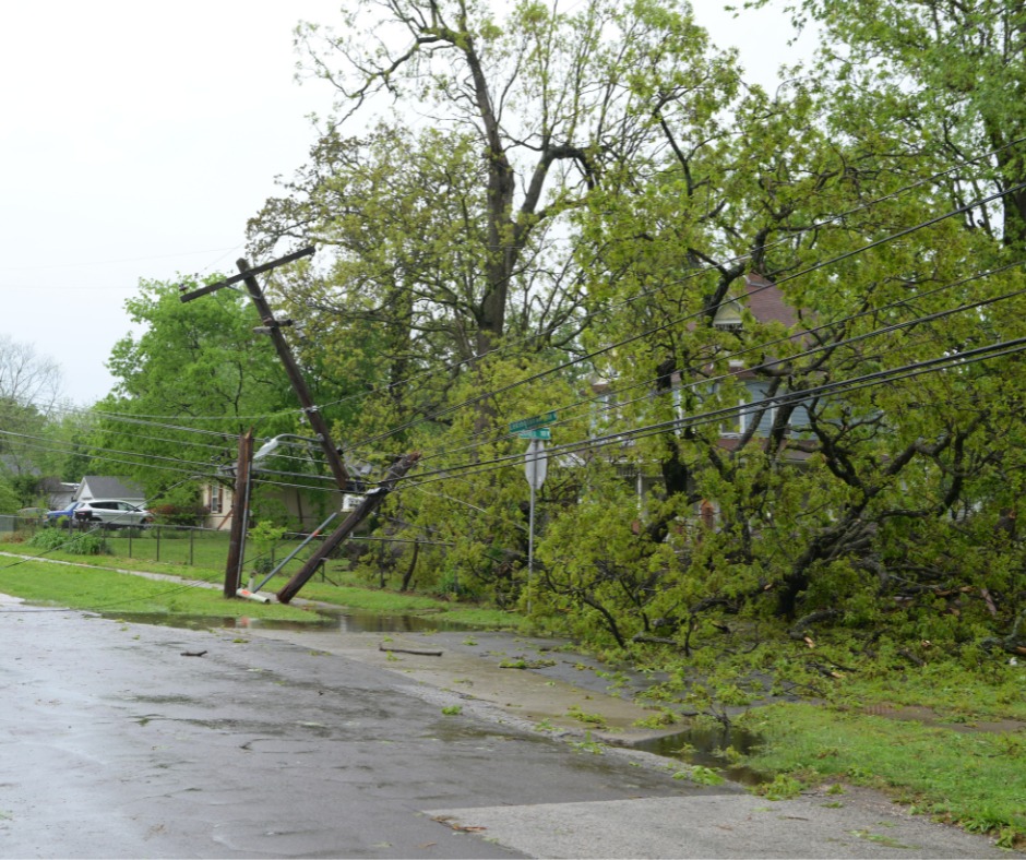
| One of many instances of trees into powerlines across the area Credit: Springfield City Utilities |
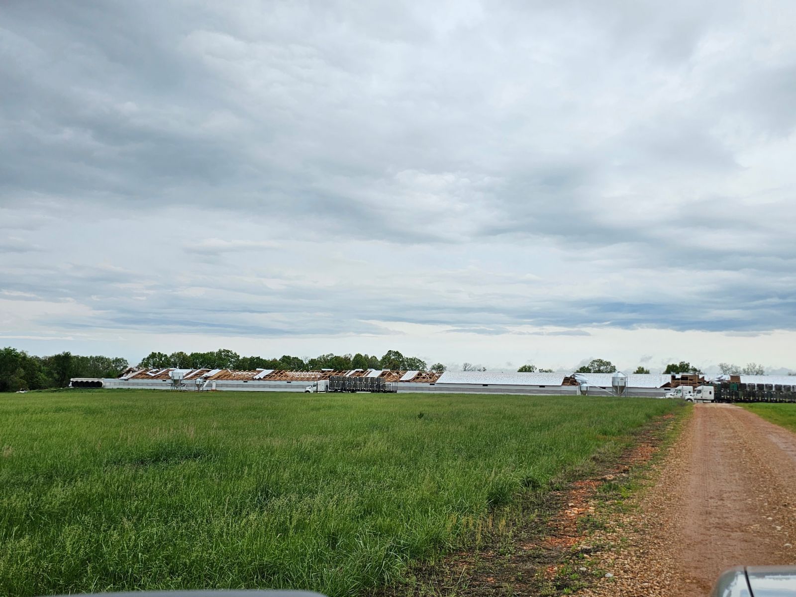
Large sign down at Hoods Truck Stop near Halltown | Extensive damage to gas station in western Greene County | Poultry barn damage in southern Lawrence County |
Radar
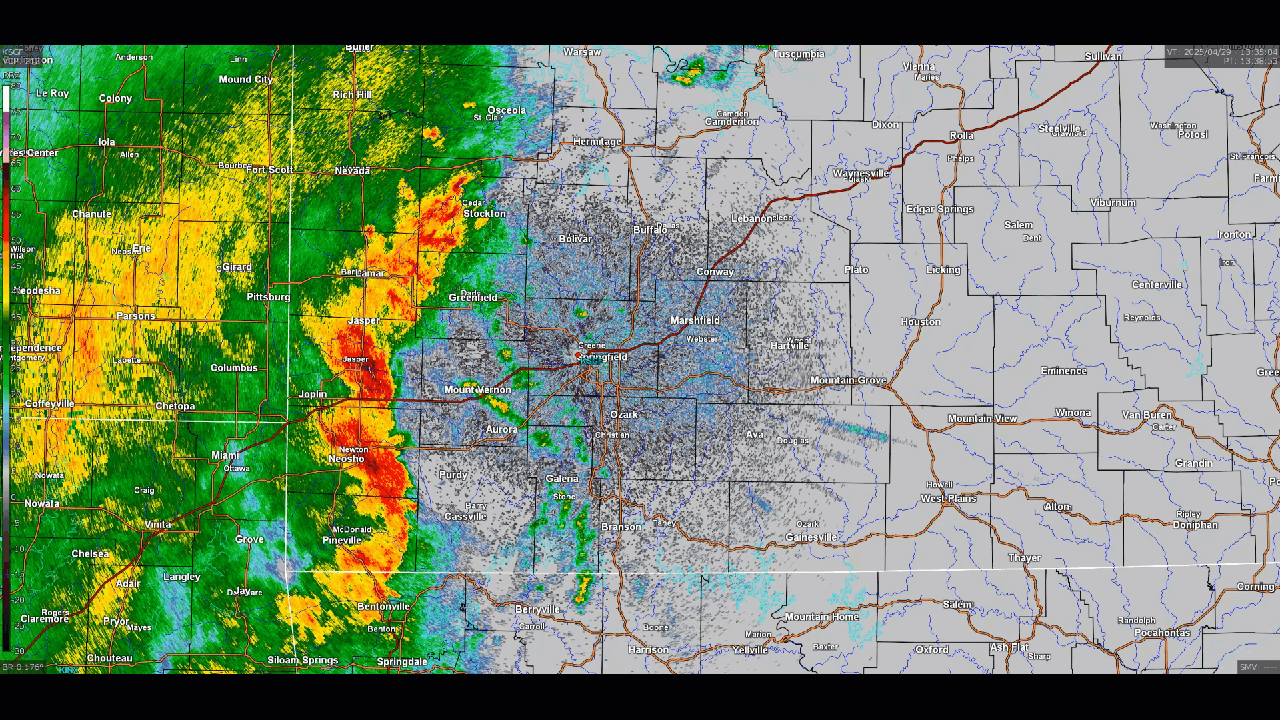
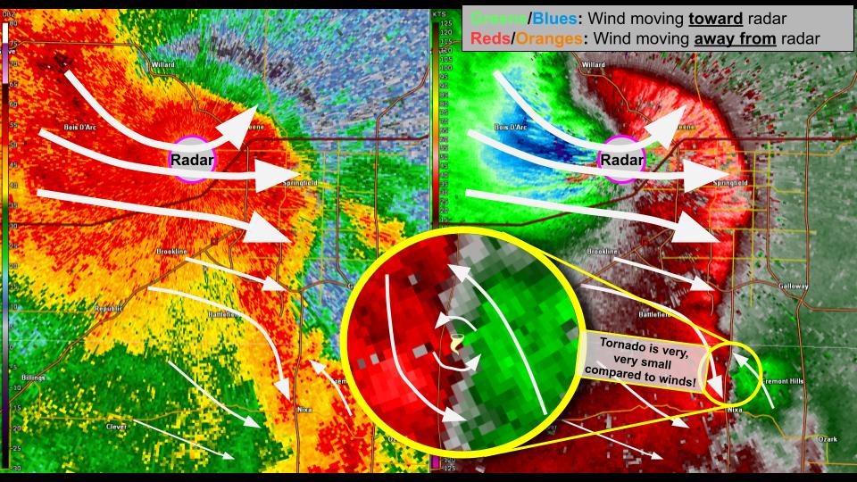
Here is a radar loop during the morning of April 29th, 2025.
.png) |
.png) |
.png) |
.png) |
| 9:21 am Base Reflectivity | 9:21 am Base Velocity | 9:34 am Base Reflectivity | 9:34 am Base Velocity |
 |
 |
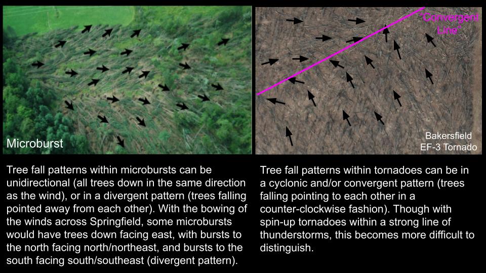 |
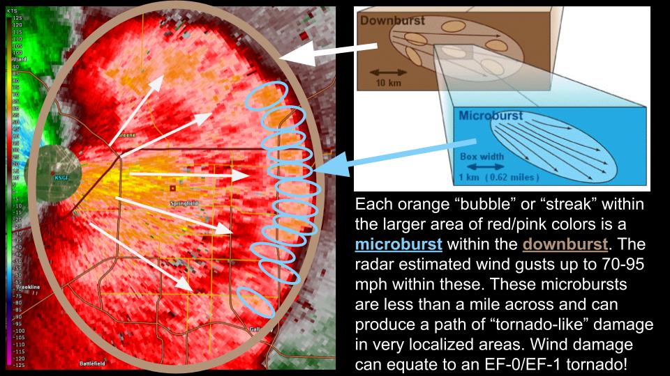
| Radar Reflectivity and Base Velocity as the storm moved through the Springfield Metro. Areas highlighting the damaging winds and rotation area. | Base Velocity description of areas of microbursts within the downburst areas. | Example of Microburst damage versus convergent tornado damage. |
Storm Reports
Here is an interactive storm report page: https://www.spc.noaa.gov/exper/reports/?&source=prelim&all&date=20250429
Below is a map of storm reports from April 29th:
.png)
 |
Media use of NWS Web News Stories is encouraged! Please acknowledge the NWS as the source of any news information accessed from this site. |
|


 Weather Story
 Weather Map
 Local Radar