Overview
| The Great "Blue Norther" of November 11th, 1911 On November 11, 1911, the central U.S. experienced one of the most dramatic cold waves to affect the United States. | 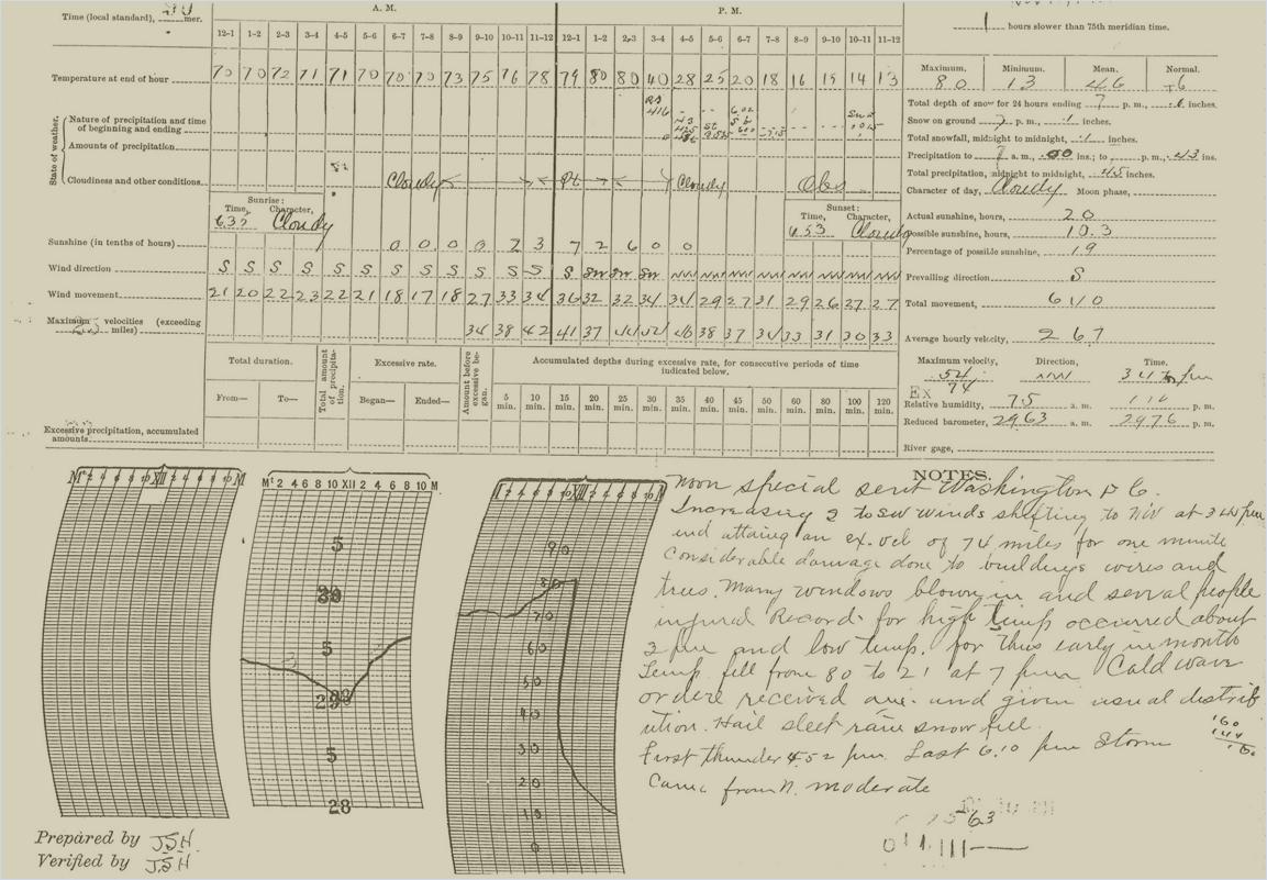 SGF Observation Chart - November 11, 1911 |
Historical Overview
The Great "Blue Norther" of November 11, 1911
This article was originally published in the Ozarks Weather Observer for the October 2003 newsletter. It was written and researched by NWS SGF Meteorologist Drew Albert.
The term "blue norther" is most commonly associated with Texas. Various other names for the same phenomenon exist over the central and southern Plains. There are also various theories as to the exact origin of the term. In general it is associated with a rapidly moving cold front (usually in the Autumn) that causes temperatures to drop quickly and that often brings with it precipitation and unsettled weather, followed by a period of blue skies and cold temperatures.
On November 11, 1911, the central U.S. experienced one of the most dramatic cold waves to affect the United States. During the early morning hours a deep Midwestern storm system, along with an associated arctic cold front, separated unseasonably warm and humid air from arctic cold. Temperatures ranged from the upper 60s and lower 70s over Missouri to the single digits in central Nebraska.
As the day wore on, record warmth was felt across much of Missouri and Oklahoma. In Kansas City, the temperature rose to a record high of 76 degrees by late morning before the arctic front moved in from the northwest. Skies became overcast, winds shifted to the northwest, and the mercury began to plummet. By early afternoon, it was cold enough to snow, and by midnight the temperature had dipped to a record cold reading of 11 degrees above zero.
In Springfield, the effects of the front were even more dramatic. Afternoon temperatures had reached record high levels by 2:00 to 3:00 pm when the mercury reached 80 degrees. South winds increased to a sustained 30 mph with gusts over 40 mph. The wind shifted to the northwest at 3:45 pm dropping the temperature to 40 degrees by 4:00 pm. The temperature continued to plummet to 20 degrees by 7 pm. Finally by midnight, a record low of 13 degrees was established. The temperature fell to 9 degrees above zero during the early morning hours on November 12th. November 11, 1911 marks the only day in the Springfield, Missouri climate record where a record high and low temperature exist on the same day.
The extreme cold was only part of the story. The huge storm also brought damaging wind. The following were notes taken by John S. Hazen, the weatherman-in-charge at Springfield in 1911:
"Increasing S to SW winds shifting to the NW at 3:45 pm and attaining an ex.(extreme)velocity of 74 miles for one minute. Considerable damage done to buildings, wires, and trees. Many windows blown in and several people injured. Record high temp. occurred about 2 pm and low temp for this early in the month. Temp fell from 80 to 21 at 7 pm. Cold wave order received and given usual distribution. Hail, sleet, rain, and snow fell. First thunder 4:52 pm. Last 6:10 pm. Storms came from north."
The rest of the Midwest was affected by the storm. Oklahoma City also established a record high of 83 degrees and record low of 17 degrees. Many areas saw the temperature plummet 50 degrees in one hour. The front produced severe thunderstorms and tornadoes across the upper Mississippi Valley, a blizzard in the Ohio Valley and the upper Midwest, and a dust storm in Oklahoma. Nine tornadoes occurred in Michigan, Illinois, Indiana, and Wisconsin. An F4 tornado occurred in Janesville, Wisconsin where 9 people were killed and 50 were injured. Within an hour after that tornado struck, survivors were working in blizzard conditions with near zero degree temperatures to rescue people trapped in tornado damage debris.
Excerpt from Monthly Weather Review - November 1911
 |
Media use of NWS Web News Stories is encouraged! Please acknowledge the NWS as the source of any news information accessed from this site. |
|


 Weather Story
 Weather Map
 Local Radar