Springfield, MO
Weather Forecast Office
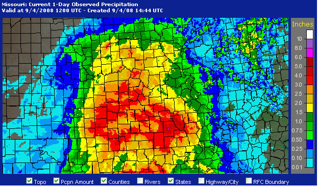
The remnants of hurricane Gustav tracked from the gulf coast north across the Ozarks bringing widespread heavy rainfall. Total rainfall amounts of 3 to 6 inches were common with some locally higher amounts. Despite the amounts flooding was relatively minor and confined primarily to small streams and low water crossings.
THE FOLLOWING ARE RAINFALL AMOUNTS AT ASOS SITES AND OTHER
RECORDING SITES ACROSS SOUTHEAST KANSAS AND THE MISSOURI OZARKS
THROUGH APPROXIMATELY NOON THURSDAY.
OSAGE BEACH AWOS (KAIZ)...2.48 INCHES
ROLLA-VICHY ASOS (KVIH)...2.82 INCHES
WEST PLAINS ASOS (KUNO)...4.61 INCHES
SPRINGFIELD ASOS (KSGF)...3.49 INCHES
JOPLIN ASOS (KJLN)........4.05 INCHES
FORT LEONARD WOOD (KTBN)..4.13 INCHES
SALEM.....................3.51 INCHES
MONETT....................3.99 INCHES
MACKS CREEK RAWS..........3.55 INCHES
MT VERNON RAWS............3.42 INCHES
SINKIN RAWS...............6.14 INCHES
AVA RAWS..................3.91 INCHES

Current Hazards
Experimental Graphical Hazardous Weather Outlook
Submit a storm report
Local Storm Reports
Current Conditions
Observations
Lake Levels
Snowfall Analysis
Road Conditions
Satellite
CoCoRaHS
Graphical Conditions
Precip. Analysis
Forecasts
Forecast Discussion
Fire Weather
Aviation
GIS Forecast Maps
Activity Planner
Severe Weather
Winter Weather
Hurricanes
FAA Center Weather
Space Weather
Climatology
Records and Normals
Monthly Climate Summary
Local
National
Drought
Climate Science
Astronomical Data
US Dept of Commerce
National Oceanic and Atmospheric Administration
National Weather Service
Springfield, MO
Springfield-Branson National Airport
5805 West Highway EE
Springfield, MO 65802-8430
Business: 417-863-8028 Recording: 417-869-4491
Comments? Questions? Please Contact Us.


 Weather Story
 Weather Map
 Local Radar