Overview
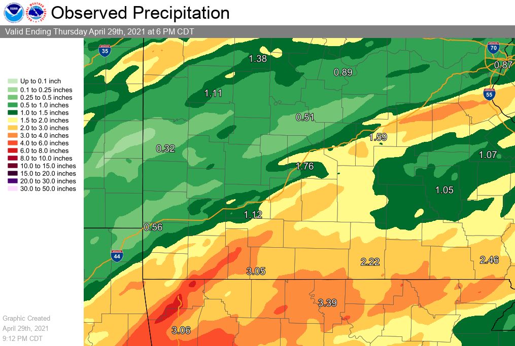
Heavy rain began to develop over southern Missouri on the night of the 27th, continuing throughout the morning of the 28th, with additional heavy rain during the late night of the 28th into the early morning of the 29th. Several inches of rainfall in a short period of time early on the 28th led to flash flooding and significant quick rises on a few area rivers and streams. A severe line segment developed during the morning of the 28th over southwest Missouri which pushed east across southern Missouri during the morning. Mesovorticies within the line segment led to several brief tornado touchdowns and some wind damage.Tornadoes:
* Download a .KMZ file for the event
|
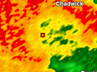
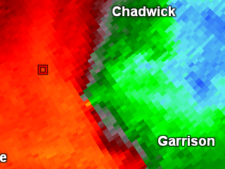
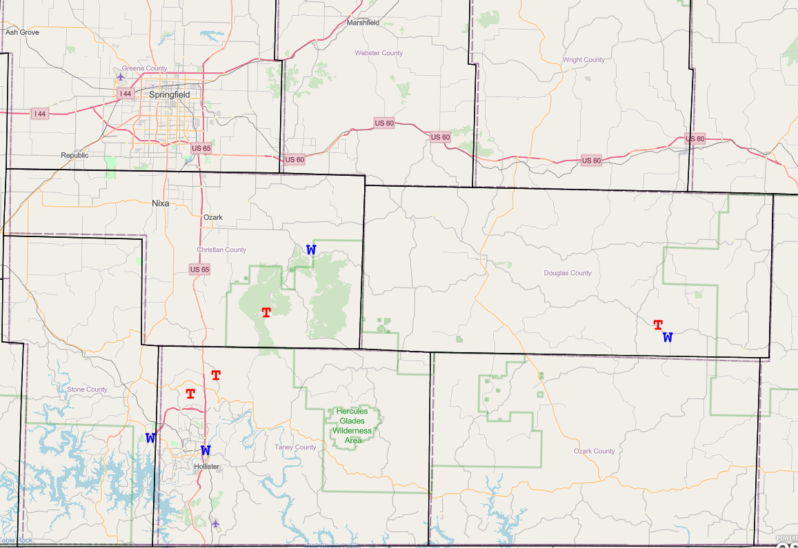
Tornado - 0.5 SW of Chadwick
Track Map 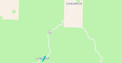 
|
||||||||||||||||
|
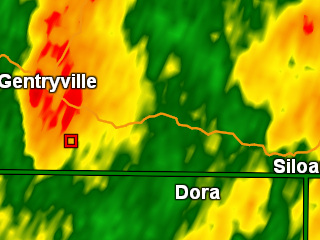
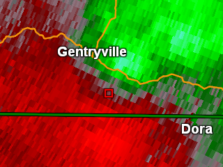
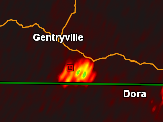
Tornado - 0.2 SE of Gentryville
Track Map 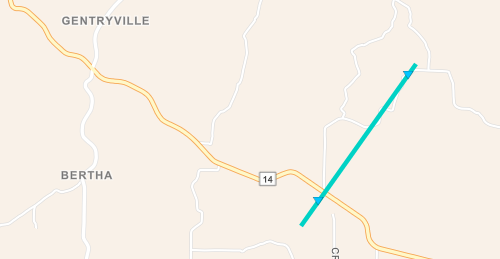
|
||||||||||||||||
|
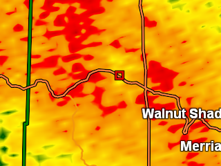
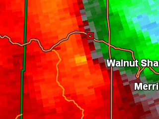
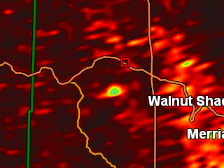
Tornado - 3 West of Walnut Shade
Track Map 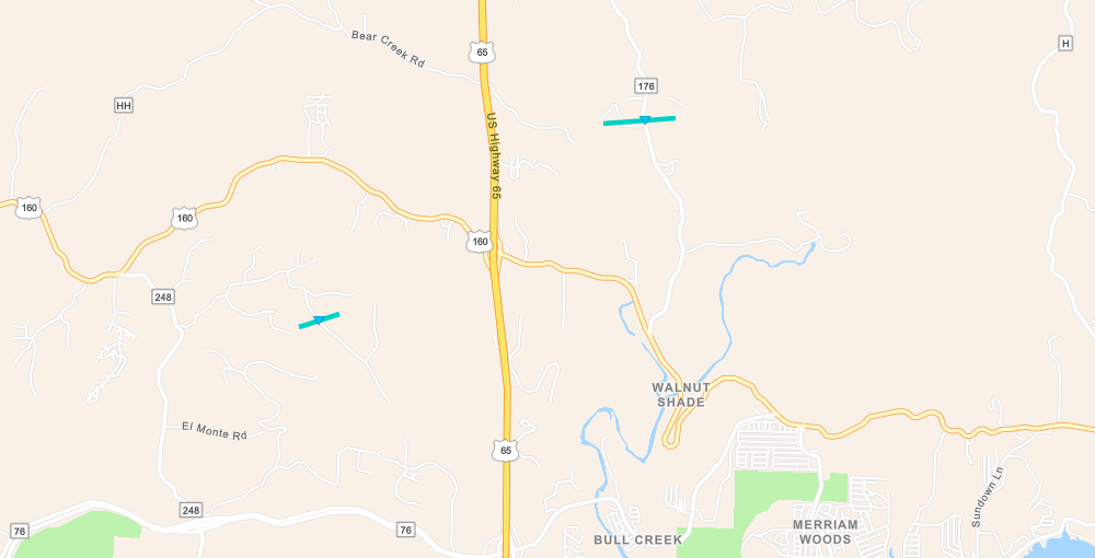
|
||||||||||||||||
|
Tornado - 0.2 miles N Walnut Shade
Track Map
|
||||||||||||||||
The Enhanced Fujita (EF) Scale classifies tornadoes into the following categories:
| EF0 Weak 65-85 mph |
EF1 Moderate 86-110 mph |
EF2 Significant 111-135 mph |
EF3 Severe 136-165 mph |
EF4 Extreme 166-200 mph |
EF5 Catastrophic 200+ mph |
 |
|||||
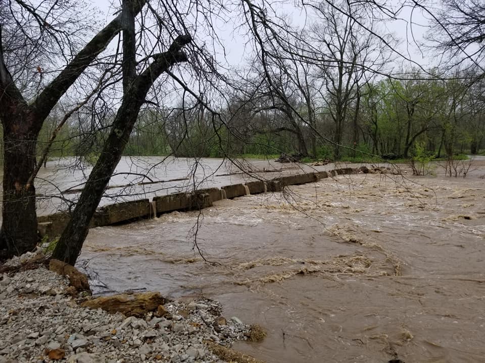
Flooding
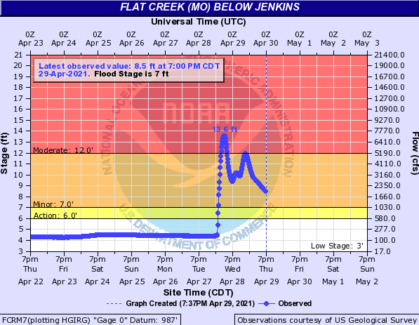
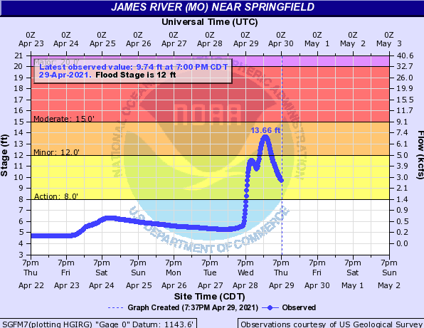
Several rounds of heavy rainfall from the overnight of the 27th through the 28th brought some flash flooding and very quick rises on some area rivers and streams.
Hydrographs
 |
 |
 |
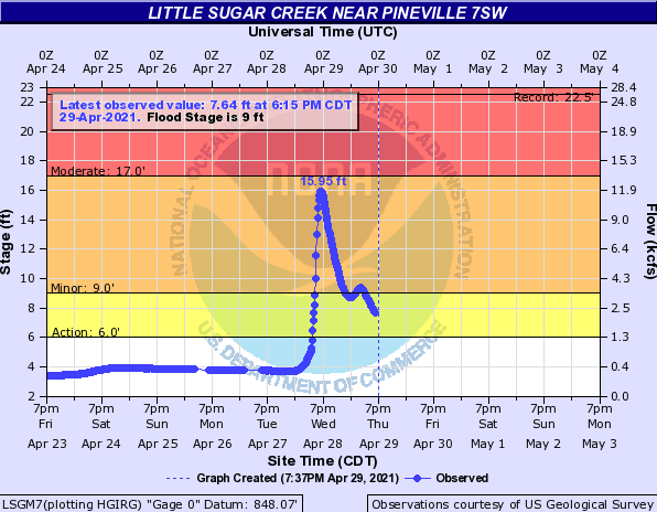 |
| Big Sugar Creek | Flat Creek | James River - Springfield | Little Sugar Creek |
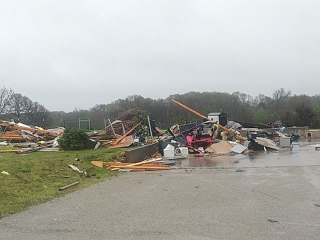
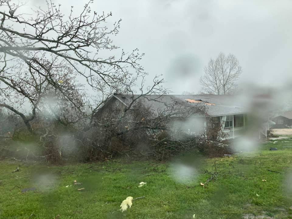
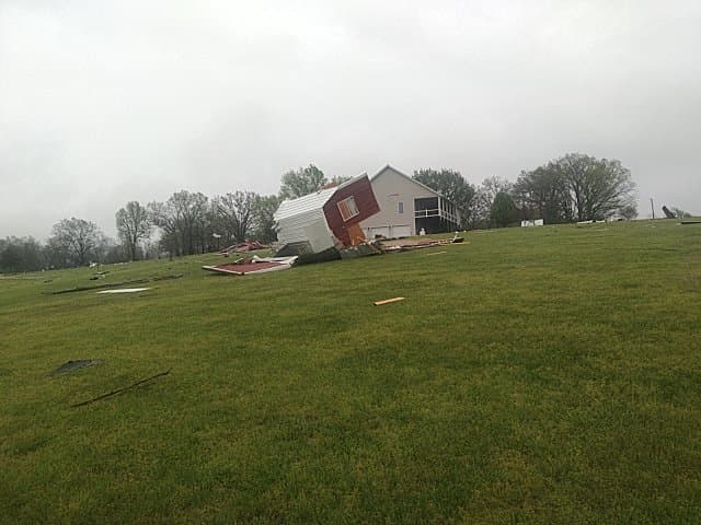
Photos
Storm damage and flooding
 |
 |
 |
 |
Radar
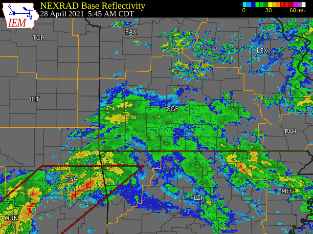
Walnut Shade, Chadwick and Gentryville Tornadoes
 |
 |
 |
 |
| Chadwick Tornado - Z | Chadwick Tornado - SRM | Gentryville Tornado - Z | Gentryville Tornado - SRM |
 |
 |
 |
 |
| Gentryville Tornado - CC | Walnut Shade Tornado - Z | Walnut Shade Tornado - SRM | Walnut Shade Tornado - CC |
Storm Reports
PRELIMINARY LOCAL STORM REPORT...SUMMARY
NATIONAL WEATHER SERVICE SPRINGFIELD MO
905 PM CDT THU APR 29 2021
..TIME... ...EVENT... ...CITY LOCATION... ...LAT.LON...
..DATE... ....MAG.... ..COUNTY LOCATION..ST.. ...SOURCE....
..REMARKS..
0410 AM NON-TSTM WND GST 1 NE AIRPORT DRIVE 37.15N 94.50W
04/28/2021 M47 MPH JASPER MO ASOS
ASOS STATION KJLN JOPLIN ASOS.
0920 AM TSTM WND DMG 1 E SILVER DOLLAR CITY 36.67N 93.33W
04/28/2021 STONE MO PUBLIC
MULTIPLE TREES DOWN AND LIGHT TOWERS BLOWN
OVER INDIAN POINT ROAD.
0925 AM TSTM WND DMG BRANSON 36.65N 93.22W
04/28/2021 TANEY MO LAW ENFORCEMENT
LARGE TREES DOWN ON HIGHWAY 76 NEAR THE
HIGHROAD AND SHEPHERD OF THE HILLS OUTDOOR
THEATER.
0930 AM TORNADO 3 W WALNUT SHADE 36.74N 93.25W
04/28/2021 TANEY MO NWS STORM SURVEY
NWS STORM SURVEY DETERMINED AN EF0 TORNADO
WITH WINDS ESTIMATED AT 70 MPH BRIEFLY
TOUCHED DOWN AT THIS LOCATION. MINOR
RESIDENTIAL DAMAGE AND SNAPPED TREES WERE
OBSERVED. PATH WIDTH WAS 50 YARDS.
0937 AM TORNADO 2 N WALNUT SHADE 36.77N 93.20W
04/28/2021 TANEY MO NWS STORM SURVEY
CORRECTS PREVIOUS TORNADO REPORT FROM 2 N
WALNUT SHADE. NWS STORM SURVEY DETERMINED AN
EF0 TORNADO WITH WINDS ESTIMATED AT 76 MPH
BRIEFLY TOUCHED DOWN AT THIS LOCATION. MINOR
RESIDENTIAL DAMAGE ALONG WITH SNAPPED AND
UPROOTED TREES WERE OBSERVED. ONE LARGE TREE
FELL INTO A HOUSE CAUSING SIGNIFICANT
DAMAGE. PATH WIDTH WAS 50 YARDS AND LENGTH
WAS AROUND A HALF MILE.
0946 AM FLASH FLOOD BRANSON 36.65N 93.22W
04/28/2021 TANEY MO EMERGENCY MNGR
NUMEROUS REPORTS OF FLOODING IN AND AROUND
BRANSON INCLUDING ROARK VALLEY AND VETERANS
BOULEVARD. ALSO A REPORT OF 2.5 INCHES OF
RAIN IN 30 MINUTES NEAR TABLE ROCK LAKE DAM.
0950 AM HEAVY RAIN SHELL KNOB 36.64N 93.63W
04/28/2021 M1.75 INCH BARRY MO AMATEUR RADIO
1.75 INCHES OF RAIN BETWEEN 7 AM AND 945 AM.
0955 AM FLASH FLOOD CAPE FAIR 36.74N 93.51W
04/28/2021 STONE MO FIRE DEPT/RESCUE
SEVERAL VEHICLES IN THE WATER AT HIGHWAY 173
NORTH OF HIGHWAY 76. ALL OCCUPANTS ARE
RESCUED.
0956 AM TORNADO 5 WNW GARRISON 36.87N 93.10W
04/28/2021 CHRISTIAN MO NWS STORM SURVEY
NWS STORM SURVEY DETERMINED AN EF0 TORNADO
WITH WINDS ESTIMATED AT 76 MPH BRIEFLY
TOUCHED DOWN AT THIS LOCATION. TREES WERE
UPROOTED AND A SHED WAS DESTROYED. PATH
WIDTH WAS 50 YARDS AND LENGTH WAS AROUND A
HALF MILE.
1002 AM FLASH FLOOD 3 E CAPE FAIR 36.73N 93.46W
04/28/2021 STONE MO FIRE DEPT/RESCUE
WATER OVER HIGHWAY 76 AT MULE BARN RD.
1003 AM FLASH FLOOD 2 SE CASSVILLE 36.66N 93.85W
04/28/2021 BARRY MO DEPT OF HIGHWAYS
76 CLOSED BOTH E AND W BOUND DUE TO
FLOODING.
1005 AM FLASH FLOOD 5 WNW EAGLE ROCK 36.59N 93.84W
04/28/2021 BARRY MO DEPT OF HIGHWAYS
MO 112 CLOSED BOTH WAYS DUE TO FLOODING.
1029 AM FLASH FLOOD 3 SSE PONCE DE LEON 36.83N 93.34W
04/28/2021 CHRISTIAN MO LAW ENFORCEMENT
SEVERAL RESIDENCES FLOODED NEAR HIGHWAYS 176
AND 160.
1030 AM FLASH FLOOD REEDS SPRING 36.75N 93.38W
04/28/2021 STONE MO PUBLIC
PICTURE ON SOCIAL MEDIA OF FLOODING THROUGH
REEDS SPRING, MO.
1030 AM TSTM WND DMG 2 ESE OLDFIELD 36.97N 93.01W
04/28/2021 CHRISTIAN MO EMERGENCY MNGR
THE ROOF WAS TORN OFF A HOME EAST OF
OLDFIELD.
1112 AM TSTM WND DMG 4 ESE GENTRYVILLE 36.83N 92.30W
04/28/2021 DOUGLAS MO AMATEUR RADIO
BARN AND RESIDENCE DAMAGED VICINITY OF
HIGHWAY 14 AND COUNTY ROAD 352 EAST OF
GENTRYVILLE.
1114 AM TORNADO 2 ESE GENTRYVILLE 36.85N 92.32W
04/28/2021 DOUGLAS MO NWS STORM SURVEY
NWS STORM SURVEY DETERMINED AN EF0 TORNADO
WITH MAXIMUM WINDS ESTIMATED AT 85 MPH
TOUCHED DOWN AT THIS LOCATION. THE MOST
SIGNIFICANT DAMAGE WAS THE DESTRUCTION OF A
THREE CAR GARAGE AND SEVERAL OUTBUILDINGS
NEAR THE START OF THE PATH. PATH WIDTH WAS
100 YARDS. THE TORNADO TRACKED TO THE
NORTHEAST FOR AROUND 2 MILES BEFORE LIFTING.
1120 AM FLASH FLOOD 3 NNE CASSVILLE 36.72N 93.85W
04/28/2021 BARRY MO DEPT OF HIGHWAYS
ROUTE Y CLOSED BOTH WAYS DUE TO FLOODING.
1124 AM FLASH FLOOD 1 ENE PONCE DE LEON 36.89N 93.33W
04/28/2021 CHRISTIAN MO DEPT OF HIGHWAYS
ROUTE V CLOSED BOTH WAYS DUE TO FLOODING.
1151 AM FLASH FLOOD 5 NNW AVA 37.01N 92.71W
04/28/2021 DOUGLAS MO AMATEUR RADIO
HIGHWAY Y AT COWSKIN CREEK NORTHWEST OF AVA
IS FLOODED.
1230 PM FLASH FLOOD 4 SSE KIRBYVILLE 36.57N 93.12W
04/28/2021 TANEY MO DEPT OF HIGHWAYS
ROUTE J CLOSED BOTH WAYS DUE TO FLOODING.
1247 PM HEAVY RAIN 6 W SHELL KNOB 36.65N 93.74W
04/28/2021 M3.93 INCH BARRY MO MESONET
CORRECTS PREVIOUS HEAVY RAIN REPORT FROM 6 W
SHELL KNOB. MESONET STATION CRWM7 CASSVILLE
RAWS.
1250 PM FLASH FLOOD 4 SSE FORDLAND 37.10N 92.92W
04/28/2021 WEBSTER MO DEPT OF HIGHWAYS
ROUTE Z CLOSED BOTH DIRECTIONS DUE TO
FLOODING.
0103 PM HEAVY RAIN 3 W LAMPE 36.57N 93.50W
04/28/2021 M2.44 INCH STONE MO MESONET
MESONET STATION DW6431 LAMPE.
0115 PM HEAVY RAIN GALENA 36.81N 93.46W
04/28/2021 M2.44 INCH STONE MO MESONET
MESONET STATION GLNM7 JAMES RIVER AT GALENA.
0116 PM HEAVY RAIN 2 NNW WEST BRANSON 36.72N 93.38W
04/28/2021 M2.75 INCH STONE MO MESONET
MESONET STATION FW9409 REEDS SPRING.
0116 PM HEAVY RAIN 1 NW SHELL KNOB 36.64N 93.64W
04/28/2021 M2.52 INCH BARRY MO MESONET
MESONET STATION FW3232 SHELL KNOB.
0117 PM HEAVY RAIN 1 ENE SEYMOUR 37.15N 92.76W
04/28/2021 M2.33 INCH WEBSTER MO MESONET
MESONET STATION FW9032 SEYMOUR.
0126 PM HEAVY RAIN 2 NE SPARTA 37.02N 93.06W
04/28/2021 M2.64 INCH CHRISTIAN MO MESONET
MESONET STATION FW8207 SPARTA.
0127 PM HEAVY RAIN 2 S CHESTNUTRIDGE 36.81N 93.25W
04/28/2021 M3.06 INCH TANEY MO MESONET
CORRECTS PREVIOUS HEAVY RAIN REPORT FROM 2 S
CHESTNUTRIDGE. MESONET STATION FW3182 WALNUT
SHADE.
0127 PM HEAVY RAIN 2 NNE SPARTA 37.03N 93.06W
04/28/2021 M2.70 INCH CHRISTIAN MO MESONET
MESONET STATION FW8222 SPARTA.
0215 PM FLASH FLOOD 4 SSW MCDOWELL 36.76N 93.81W
04/28/2021 BARRY MO DEPT OF HIGHWAYS
ROUTE U CLOSED BOTH WAYS DUE TO FLOODING.
0225 PM FLASH FLOOD MCDOWELL 36.82N 93.79W
04/28/2021 BARRY MO DEPT OF HIGHWAYS
ROUTE C CLOSED BOTH WAYS DUE TO FLOODING.
0230 PM FLASH FLOOD 5 NE MANSFIELD 37.17N 92.53W
04/28/2021 WRIGHT MO DEPT OF HIGHWAYS
ROUTE AB CLOSED BOTH WAYS DUE TO FLOODING.
0230 PM FLASH FLOOD 4 SSW HARDENVILLE 36.54N 92.40W
04/28/2021 OZARK MO DEPT OF HIGHWAYS
ROUTE T CLOSED BOTH WAYS DUE TO FLOODING.
0233 PM FLASH FLOOD 9 SSE POWELL 36.51N 94.11W
04/28/2021 MCDONALD MO DEPT OF HIGHWAYS
ROUTE KK CLOSED BOTH WAYS DUE TO FLOODING.
0238 PM FLASH FLOOD 3 S ROGERSVILLE 37.07N 93.05W
04/28/2021 CHRISTIAN MO DEPT OF HIGHWAYS
ROUTE U CLOSED BOTH WAYS DUE TO FLOODING.
0242 PM FLASH FLOOD 1 WSW MOODY 36.52N 92.01W
04/28/2021 HOWELL MO DEPT OF HIGHWAYS
MO-142 CLOSED BOTH WAYS DUE TO FLOODING.
0326 PM FLASH FLOOD 2 SSW COMPETITION 37.46N 92.45W
04/28/2021 WRIGHT MO DEPT OF HIGHWAYS
STATE HIGHWAY Z AT ELK CREEK IS CLOSED DUE
TO FLOODING.
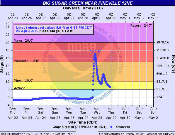
0345 PM FLASH FLOOD POWELL 36.62N 94.18W
04/28/2021 MCDONALD MO MESONET
BIG SUGAR CREEK ROSE OVER 5.5 FEET IN 1 HOUR
AND EVENTUALLY CRESTED AT 17.1 FEET WHICH IS
MODERATE FLOOD STAGE.
0530 PM FLASH FLOOD 1 SE PINEVILLE 36.58N 94.37W
04/28/2021 MCDONALD MO MESONET
LITTLE SUGAR CREEK ROSE SHARPLY TO A STAGE
OF NEARLY 16 FEET.
0211 AM FLASH FLOOD 2 WSW SAINT JAMES 37.99N 91.65W
04/29/2021 PHELPS MO LAW ENFORCEMENT
WATER OVER THE ROADWAY ON COUNTY ROAD 3270.
0347 AM HEAVY RAIN 6 W SHELL KNOB 36.65N 93.74W
04/29/2021 M4.98 INCH BARRY MO MESONET
A 24 HOUR TOTAL AT THE CASSVILLE RAWS.
0600 AM HEAVY RAIN 1 SE PINEVILLE 36.58N 94.37W
04/29/2021 M2.52 INCH MCDONALD MO MESONET
MESONET STATION LSGM7 LITTLE SUGAR CREEK AT
PINEVILLE.
0647 AM HEAVY RAIN 6 W SHELL KNOB 36.65N 93.74W
04/29/2021 M4.71 INCH BARRY MO MESONET
MESONET STATION CRWM7 CASSVILLE RAWS.
0653 AM HEAVY RAIN 3 N RUETER 36.65N 92.87W
04/29/2021 M2.83 INCH TANEY MO MESONET
MESONET STATION BEVM7 AVA/REUTER RAWS.
0659 AM HEAVY RAIN 3 ESE BATTLEFIELD 37.11N 93.32W
04/29/2021 M2.57 INCH GREENE MO MESONET
MESONET STATION JRRM7 JAMES RIVER - S.
SPRINGFIELD.
0700 AM HEAVY RAIN 3 SE TABLE ROCK 36.58N 93.26W
04/29/2021 M2.66 INCH TANEY MO COCORAHS
COCORAHS STATION MO-TY-12 HOLLISTER 3.8 SW.
0700 AM HEAVY RAIN 6 NE GOLDEN 36.57N 93.57W
04/29/2021 M3.58 INCH STONE MO COCORAHS
COCORAHS STATION MO-SE-15 EMERALD BEACH 5.5
E.
0700 AM HEAVY RAIN 4 NE FORT LEONARD WOOD 37.75N 92.11W
04/29/2021 M2.50 INCH PULASKI MO CO-OP OBSERVER
CO-OP OBSERVER STATION FLWM7 FORT LEONARD
WOOD COOP.
0700 AM HEAVY RAIN 1 SE SAINT JAMES 37.99N 91.60W
04/29/2021 M3.20 INCH PHELPS MO COCORAHS
COCORAHS STATION MO-PH-20 ST. JAMES 1.2 SE.
0700 AM HEAVY RAIN 3 S ROLLA 37.91N 91.77W
04/29/2021 M2.71 INCH PHELPS MO COCORAHS
COCORAHS STATION MO-PH-56 ROLLA 2.8 S.
0700 AM HEAVY RAIN 5 SSE CASSVILLE 36.61N 93.84W
04/29/2021 M4.24 INCH BARRY MO COCORAHS
COCORAHS STATION MO-BY-25 CASSVILLE 4.8 SSE.
0700 AM HEAVY RAIN 5 W WASHBURN 36.58N 94.05W
04/29/2021 M2.75 INCH BARRY MO CO-OP OBSERVER
CO-OP OBSERVER STATION WABM7 WASHBURN 5 W
COOP.
0703 AM HEAVY RAIN 3 W LAMPE 36.57N 93.50W
04/29/2021 M3.55 INCH STONE MO MESONET
MESONET STATION DW6431 LAMPE.
0715 AM HEAVY RAIN GALENA 36.81N 93.46W
04/29/2021 M2.61 INCH STONE MO MESONET
MESONET STATION GLNM7 JAMES RIVER AT GALENA.
0730 AM HEAVY RAIN 1 W BRANSON 36.64N 93.24W
04/29/2021 M2.87 INCH TANEY MO MESONET
MESONET STATION FW2148 BRANSON.
0730 AM HEAVY RAIN 3 SW WALNUT SHADE 36.70N 93.23W
04/29/2021 M2.65 INCH TANEY MO MESONET
MESONET STATION FW9611 BRANSON.
0730 AM HEAVY RAIN 2 NW BRANSON 36.66N 93.25W
04/29/2021 M2.54 INCH TANEY MO MESONET
MESONET STATION FW2149 BRANSON.
0730 AM HEAVY RAIN 2 NNW WEST BRANSON 36.72N 93.38W
04/29/2021 M3.67 INCH STONE MO MESONET
MESONET STATION FW9409 REEDS SPRING.
0730 AM HEAVY RAIN 6 SW THEODOSIA 36.52N 92.75W
04/29/2021 M3.10 INCH OZARK MO COCORAHS
COCORAHS STATION MO-OZ-2 THEODOSIA 6.2 SW.
0730 AM HEAVY RAIN THORNFIELD 36.71N 92.66W
04/29/2021 M2.55 INCH OZARK MO MESONET
MESONET STATION TFDM7 NORTH LITTLE FORK AT
THORNFIELD.
0730 AM HEAVY RAIN 3 WNW MYRTLE 36.52N 91.31W
04/29/2021 M4.80 INCH OREGON MO COCORAHS
COCORAHS STATION MO-OR-26 MYRTLE 2.5 WNW.
0731 AM HEAVY RAIN 1 ENE SEYMOUR 37.15N 92.76W
04/29/2021 M3.09 INCH WEBSTER MO MESONET
MESONET STATION FW9032 SEYMOUR.
0731 AM HEAVY RAIN 1 SW MARSHFIELD 37.32N 92.92W
04/29/2021 M2.72 INCH WEBSTER MO MESONET
MESONET STATION FW8938 MARSHFIELD.
0736 AM HEAVY RAIN 3 NNE TABLE ROCK 36.64N 93.29W
04/29/2021 M3.28 INCH TANEY MO PUBLIC
0740 AM HEAVY RAIN 1 SW WALNUT SHADE 36.72N 93.21W
04/29/2021 M2.64 INCH TANEY MO MESONET
MESONET STATION BBCM7 BULL CREEK.
0740 AM HEAVY RAIN 2 NE SPARTA 37.02N 93.06W
04/29/2021 M3.09 INCH CHRISTIAN MO MESONET
MESONET STATION FW8207 SPARTA.
0741 AM HEAVY RAIN 2 NNE SPARTA 37.03N 93.06W
04/29/2021 M3.01 INCH CHRISTIAN MO MESONET
MESONET STATION FW8222 SPARTA.
0742 AM HEAVY RAIN BRANSON 36.64N 93.22W
04/29/2021 M2.94 INCH TANEY MO MESONET
MESONET STATION FW6784 BRANSON.
0742 AM HEAVY RAIN 2 S CHESTNUTRIDGE 36.81N 93.25W
04/29/2021 M3.24 INCH TANEY MO MESONET
MESONET STATION FW3182 WALNUT SHADE.
0743 AM HEAVY RAIN BRANSON 36.65N 93.22W
04/29/2021 M3.08 INCH TANEY MO MESONET
MESONET STATION FW6785 BRANSON.
0744 AM HEAVY RAIN 1 NNE CASSVILLE 36.68N 93.86W
04/29/2021 M2.78 INCH BARRY MO MESONET
MESONET STATION FW9035 CASSVILLE.
0745 AM HEAVY RAIN 3 NNE NORTHVIEW 37.32N 92.98W
04/29/2021 M2.61 INCH WEBSTER MO MESONET
MESONET STATION CW2303 4 WSW MARSHFIELD.
0745 AM HEAVY RAIN 1 NW SHELL KNOB 36.64N 93.64W
04/29/2021 M3.62 INCH BARRY MO MESONET
MESONET STATION FW3232 SHELL KNOB.
0800 AM HEAVY RAIN ALTON 36.69N 91.40W
04/29/2021 M2.58 INCH OREGON MO CO-OP OBSERVER
24HR TOTAL. ONE INCH FELL AROUND 2PM
YESTERDAY. REST THROUGH THE NIGHT.
0800 AM HEAVY RAIN 2 SE WASHBURN 36.57N 93.94W
04/29/2021 M4.06 INCH BARRY MO COCORAHS
COCORAHS STATION MO-BY-3 SELIGMAN 3.0 N.
Rain Reports
 |
Media use of NWS Web News Stories is encouraged! Please acknowledge the NWS as the source of any news information accessed from this site. |
|


 Weather Story
 Weather Map
 Local Radar